|
2. OFFICIAL PLAN AND ZONING - 3211 GREENBANK PLAN OFFICIEL ET ZONAGE- 3211, CHEMIN GREENBANK |
Committee recommendationS
(This matter is subject to Bill 51)
That
the Planning and Environment Committee recommend Council:
1. Approve and adopt an amendment to the
Official Plan, Volume 2A, South Nepean Area 7, to redesignate part of 3211
Greenbank Road, as shown on Document 1 and as detailed in Document 2.
2. Approve an amendment to the Zoning By-law
2008-250, to change the zoning of part of 3211 Greenbank Road, as shown on
Document 1 and as detailed in Documents 3 and 4.
RecommandationS DU Comité
(Cette question est assujettie au Règlement
51)
Que le Comité de l’urbanisme et de l’environment recommande au Conseil :
1. Approuver et adopter une modification au
Plan officiel, volume 2A, Centre d’activité de Nepean-Sud, secteur 7, visant à
modifier la désignation d’une partie de la propriété située au 3211, chemin
Greenbank, comme l’illustre le document 1 et le précise le document 2.
2. Approuver une modification au Règlement de
zonage 2008-250 visant à modifier la désignation d’une partie de la propriété
située au 3211, chemin Greenbank, comme l’illustre le document 1 et le
précisent les documents 3 et 4.
Documentation
1.
Deputy
City Manager's report, Infrastructure Services and Community Sustainability,
dated 22 December 2009 (ACS2010-ICS-PGM-0016).
Report to/Rapport au :
Planning
and Environment Committee
Comité de l'urbanisme et de l'environnement
22 December 2009 / le 22 décembre
2009
Submitted by/Soumis par : Nancy Schepers, Deputy
City Manager/Directrice municipale adjointe,
Infrastructure Services and Community Sustainability/Services d'infrastructure et Viabilité des collectivités
Contact Person/Personne-ressource :
Michael Wildman, Manager/Gestionnaire, Development Review-Suburban
Services/Examen des projets d'aménagement-Services suburbains, Planning and
Growth Management/Urbanisme et Gestion de la croissance
(613) 580-2424, 27811 Mike.Wildman@ottawa.ca
|
SUBJECT: |
OFFICIAL PLAN and ZONING - 3211
Greenbank road (FILE NO. D01-01-09-0003 / D02-02-09-0040) |
|
|
|
|
OBJET : |
REPORT RECOMMENDATIONS
That the Planning and Environment Committee recommend Council:
1. Approve and adopt an
amendment to the Official Plan, Volume 2A, South Nepean Area 7, to redesignate
part of 3211 Greenbank Road, as shown on Document 1 and as detailed in Document
2.
2. Approve an amendment
to the Zoning By-law 2008-250, to change the zoning of part of 3211 Greenbank
Road, as shown on Document 1 and as detailed in Documents 3 and 4.
RECOMMANDATIONS DU
RAPPORT
Que le Comité de l’urbanisme et de
l’environment recommande au Conseil :
1. Approuver
et adopter une modification au Plan officiel, volume 2A, Centre d’activité de
Nepean-Sud, secteur 7, visant à modifier la désignation d’une partie de la
propriété située au 3211, chemin Greenbank, comme l’illustre le document 1 et
le précise le document 2.
2. Approuver
une modification au Règlement de zonage 2008-250 visant à modifier la
désignation d’une partie de la propriété située au 3211, chemin Greenbank,
comme l’illustre le document 1 et le précisent les documents 3 et 4.
BACKGROUND
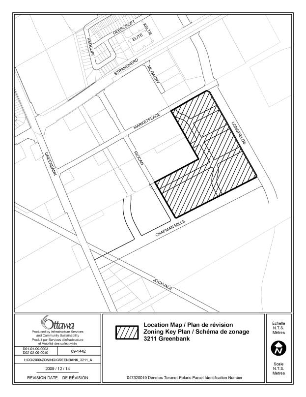
These applications affect part of 3211 Greenbank Road, generally located south of Strandherd Drive and east of Greenbank Road in the Barrhaven community. The property is bounded by the Strandherd retail district and Marketplace Avenue to the north, Longfields Drive to the east, Chapman Mills Drive to the south and Riocan Avenue to the west, as shown on Document 1. The site is 13 hectares in size, is vacant, and does not contain any significant vegetation. These lands are designated Mixed Use Centre/Town Centre in the Official Plan, and Mid Rise Mixed-Use and Neighbourhood Park in the South Nepean Town Centre Secondary Plan. They are currently zoned as Development Reserve (DR) in Zoning By-Law 2008-250. Lands to the east, west and south are planned for future residential and mixed-use development but are currently vacant.
The applicant intends to build a mixed-use, moderately high-density development comprising residential, commercial and open space uses on the subject lands. The proposed built form consists of four-storey buildings primarily, and four, 12-storey buildings. Amendments to the Official Plan and to the Zoning By-law are required to accommodate the proposed development.
The applicant has requested amendments to the Official Plan and to the Zoning By-law for lands which are also subject to a concurrent Plan of Subdivision application. The lands are 18.3 hectares in size, but the proposed amendments affect only 13 hectares. This is because three blocks on the Draft Plan of Subdivision have been set aside for future development.
Official Plan and Zoning By-law
The subject lands are designated as Mixed Use Centre – Town Centre in the Official Plan, and are divided in two policy areas in the Secondary Plan, South Nepean Area 7. These are: Mid Rise Mixed-Use and Neighbourhood Park.
The Mixed-Use Centre designation applies to areas that have been identified as strategic locations on the rapid-transit network and have immediate access to major roads. The designation permits mixed-use development with an emphasis on commercial uses and residential uses in the same building with retail uses located at grade, but also single use retail and office commercial uses and residential apartments. Mixed-Use Centres are an essential component of the City’s growth management strategy and are designed to achieve compact mixed-use developments, which optimize the use of land and take advantage of the opportunities offered by transit for commuting and ease of access on foot and bicycle. The proposal is consistent with the Mixed-Use Centre/Town Centre designation.
The Secondary Plan policies provide density performance standards in terms of minimum and maximum building heights and net density targets for residential uses. In the High Rise Mixed-Use policy area, the minimum building height is six storeys, the maximum building height is 12 storeys, and the net density target for residential uses is 250 units per hectare (uph).
In the Mid Rise Mixed-Use policy area, the permitted building height ranges from four storeys to six storeys, and the net density target for residential uses is 200 units per hectare.
The subject lands are zoned Development Reserve (DR) in Zoning By-law 2008-250. This zoning, which is typically placed on lands that are reserved for future development, does not permit mixed-use developments.
Requested Official Plan Amendment
The applicant proposes the following amendments to the Secondary Plan:
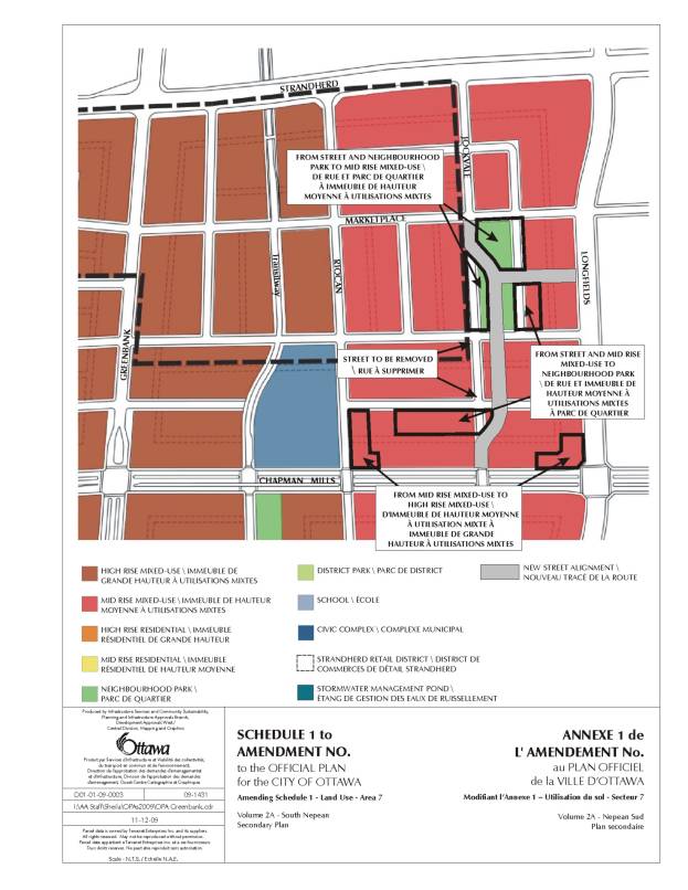
- To amend Schedule 1 – Land Use to change the designation of portions of the lands (northeast corner of Chapman Mills Drive and Riocan Avenue, and northwest corner of Chapman Mills Drive and Longfields Drive) from Mid Rise Mixed-Use to High Rise-Mixed Use;
- To reduce the net density target for residential uses in the Mid Rise Mixed-Use policy area from 200 uph to 150 uph;
- To remove the maximum lot coverage of 50 per cent of the total of any block for stand-alone residential buildings;
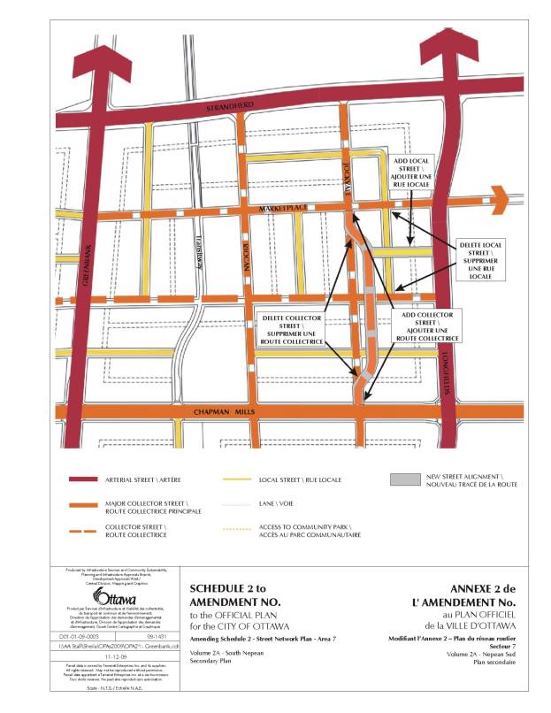
- To amend Schedule 2 – Street Network Plan to realign a portion of the extension of Jockvale Road north of Chapman Mills Drive and south of Marketplace Avenue;
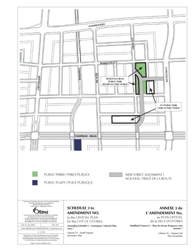
- To reduce the minimum size of a neighbourhood park from 0.4 hectares to 0.35 hectares;
- To amend Schedule 5 – Greenspace Network Plan to introduce a new park location.
The details of the recommended Official Plan Amendment are contained in Document 2 hereto attached.
DISCUSSION
High Rise Mixed-Use at Riocan/Chapman Mills/Longfields
The introduction of the six- to 12-storey buildings at the Riocan/Chapman Mills/Longfields intersections north of Chapman Mills Drive is desirable, as major intersections are good locations for taller buildings and provide an opportunity to locate mixed-use development by concentrating height and mass at gateways. Chapman Mills Drive is designed to be a highly urban street with Bus Rapid Transit occupying the central portion of the right-of-way. Higher profile in these locations will be beneficial to rapid transit and contribute to the overall objective of intensification in the Town Centre.
Development Density
In support of the proposed amendments, the applicant has submitted a development Concept Plan illustrating the proposed street and block patterns for the subject lands, and how these relate to existing and planned street and block patterns. In addition, the Concept Plan illustrates land use and density distribution, the built form on the proposed blocks, lands for public parks, and the phasing of the proposed development.
In essence, the Concept Plan consists of four-storey buildings primarily, and four, 12-storey buildings located adjacent to two intersections of planned transit routes (Riocan Avenue/Chapman Mills/Longfields), and in proximity to a portion of the planned north south transit way.
All buildings along transit routes will be mixed-use with ground floor commercial and residential uses on upper storeys. Parking for the greater majority of buildings will be underground, so that the development would be compact, with very limited site area used for surface parking. Initial estimates indicate that the conceptual development would create a total of 1144 dwelling units, with the 12-storey buildings exceeding the density target of 250 uph and the four-storey buildings falling short on the 200 uph target. However the proposed development would achieve an overall residential density of 167 uph net.
Although the Secondary Plan for the area generally permits a maximum of six storeys in the Mid Rise Mixed-Use policy area, the applicant has explained that the economics of land use and current market conditions would not support building six-storey buildings. This leaves the four‑storey height in the form of walk-up apartments or stacked townhomes as the contemplated built form, which reduces the maximum development density that can currently be attained at this site. As the Secondary Plan requires that the number of dwellings be tracked on a neighbourhood basis at the time of development approval to ensure that density targets are being met, the applicant is requesting a reduction of the residential net density target to 150 uph to reflect what is realistic under the circumstances.
In evaluating the merits of the proposed density adjustment request, staff have examined whether the Official Plan’s goal promoting “development that reflects a dense, compact and transit-supportive built form” can still be achieved through this proposal.
Canadian communities tend to consider net densities above 95 uph as high density, with 96 uph being generally viewed as the lower end of the range of high densities. Typically, four-storey walk-up buildings yield a net density approximating 96 uph. The proposed four-storey buildings average a net residential density of 114 uph. Therefore, the proposed development fits within the high density development category.
It is a requirement of the Provincial Policy Statement (PPS) that new development taking place in designated growth areas have a compact form, a mix of uses and densities that allow for the efficient use of land, infrastructure and public service facilities. Compact development usually concerns clustering of land development - which is a factor of density, and generally means that the space needs of a population can be satisfied with less land area. Indeed compact development is considered to be the most suitable urban form because it can significantly reduce the consumption of energy and land resources. With building heights of four and 12 storeys clustered reasonably close to each other, and with the greater majority of parking spaces being underground, the proposed development reflects a compact pattern, in contrast to the traditional single-use low density developments with vast expanses of surface parking.
An important consideration is whether the proposal is transit supportive. The PPS states that minimum density targets must be established along transit corridors. The Ministry of Municipal Affairs and Housing referred the City of Ottawa to a study by IBI Group (2007), which deals with transit in the Greater Toronto Area and Hamilton. The report establishes minimum densities for various levels of transit service, expressed as People and Jobs per Gross Hectare. Based on the findings of that study, the City of Ottawa’s Research and Forecasting Section, in its report titled “Residential Land Strategy for Ottawa, 2006-2031, February 2009” determined that a density range of 170 to 286 People and Jobs per Hectare Net (pjh) has a transit potential for higher order Bus Rapid Transit/Light Rail Transit (BRT/LRT), while densities above 286 pjh offer higher order transit potential for Subway transit. The density target expressed in “People and Jobs per Hectare” means that the target represents the combined minimum number of residents or employees that must be accommodated by any development subject to the target.
The Canada 2006 Census indicates Dwelling Occupancy Rates (DOR) of 2.06 and 1.62 Persons per household for a stacked townhouse and an apartment, respectively. The proposed development includes 532 stacked townhouses (991 people) and 612 apartments (1,095 people) within a net area of 6.89 hectares, which represents a density of 302 Persons and Jobs Per Hectare Net. This density surpasses the range of densities considered to have a potential for higher order BRT/LRT or Subway transit.
Stand-alone
residential – 50 per cent Maximum Lot Coverage
The lifting of this restriction on the subject lands is desirable, as it will permit a compact pattern of development while providing a greater flexibility in the distribution of mixed-use and stand-alone residential buildings on the basis of locational attributes. The emphasis will be to locate mixed-use buildings with ground floor commercial adjacent to transit routes.
Realignment of New Jockvale Road north of Chapman Mills Drive
The shift easterly of this road results in a streetscape objective. The current alignment would result in direct view of the rear of the “big box” retail component of the Strandherd Retail District, which is not a desirable backdrop for the future residential community. The shift eastward allows for a tier of housing between the collector and the retail, thus more appropriately addressing site design concerns. The shifting does result in a minor curve at both ends of the realignment in order to match the existing alignment at Marketplace Avenue and Chapman Mills Drive. This deviation of the planned grid pattern is considered minor as it will not negatively affect connectivity for motorists, cyclists and pedestrians, will not create any circuitous road pattern and will maintain visual coherence, functional efficiency and all other objectives of the grid pattern.
Parkland size and distribution
The Secondary Plan states that a park must have a minimum area of 0.4 hectares. The conceptual design of the community proposes a new park location within the southern portion of the amendment area, the effect of which will be to split the parkland area in two smaller parks of 0.56 hectares and 0.36 hectares. This would better achieve the urban park/open space objectives of the South Nepean Community Design Plan by more evenly distributing parkland within the entire amendment area. The two parks would be connected by a greenway located east of the realigned north south collector. The location of a park within the south portion of the amendment area will respond better to the need created by the introduction of the four, 12 storey buildings. Both park locations would still adhere to the CDP’s key requirements for parks to have at least three sides that are entirely open to the street, and to not have rear or side yards adjacent on their fourth side.
The proposed reduction of the minimum area for a park from 0.4 hectares to 0.35 hectares is minor and results from a combination of the above redistribution of parkland and the need to suitably fit a park and two townhouse blocks with underground parking within an area bounded by four streets.
Zoning By-law Amendment
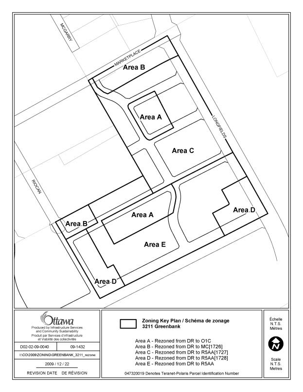
The details of the recommended zoning are included in Documents 3 and 4.
The applicant
proposes to change the zoning of the lands from DR - Development Reserve to O1
– Parks and Open Space Zone; MC
[exception] – Mixed-Use Centre Zone, Exception; and R5AA [exceptions] –
Residential Fifth Density Zone, AA Subzone, Exceptions.
The O1 zone is proposed in order to recognize the parklands that are being created through the plan of subdivision and are included on the Concept Plan. However, the generic O1 zone that the applicant is proposing permits uses including a community garden and an environmental preserve and education area, which are not practical considering the size of each proposed park and their locations. Therefore staff recommends that the parklands be rezoned O1C – Parks and Open Space Zone, Subzone C, where the only permitted use is a park.
The MC [exception] – Mixed-Use Centre, Exception zoning and the R5AA - Residential Fifth Density Zone, AA Subzone, Exceptions are designed to generally permit the uses permitted under the generic MC and R5A zones, but with specific provisions for building height, minimum yard setbacks and minimum parking requirements. Building heights of four storeys minimum and six storeys maximum are required in all zones except the sites for 12-storey buildings, where six to 12 storeys are required. The minimum building heights and reduced minimum yard setbacks are required to ensure a compact development pattern and transit-supportive densities.
Due to their convenient access to transit and as an incentive for mixed-use, it is proposed that commercial uses within the amendment area be exempt from minimum parking requirements. For residential uses staff recommends minimum parking of one space per unit for the first four storeys and 0.75 spaces per unit for any additional storeys over four storeys. The reduction of minimum parking requirements for units above the fourth storey is intended to recognize the proximity of the development to rapid transit.
In amendment areas with frontage on Chapman Mills Drive, Longfields Drive, and Riocan Avenue, exceptions are proposed to permit additional commercial uses at grade in residential buildings, i.e. office, medical facility, retail store, service and repair shop, personal service and convenience store uses, in order to enhance live-work home opportunities.
The proposed zoning amendments are consistent with the Official Plan objective to promote compact and transit-friendly mixed-use developments in Town Centres.
The applicant has submitted a Servicing Brief, which is undergoing a detailed review as part of the Plan of Subdivision application. The report does not indicate any issue with the capacity of planned infrastructure to service the proposed development.
The applicant
submitted a Transportation Impact Assessment report for the first two phases of
the proposed development, and the report concludes that the site would have a
minor impact to the surrounding transportation network and would not require
additional infrastructure modifications to the surrounding transportation
system beyond the implementation of the southerly extension of Longfields
Drive.
RURAL
IMPLICATIONS
N/A
CONSULTATION
Notice of this application was carried out in accordance with the City's Public Notification and Consultation Policy.
Detailed responses to the notification/circulation are provided in Document 5.
COMMENTS BY
THE WARD COUNCILLOR
Councillor Desroches has expressed concerns about the proposed reduction of minimum parking requirements for residential units above the fourth storey.
LEGAL/RISK
MANAGEMENT IMPLICATIONS:
There are no legal/risk management implications associated with this report.
CITY STRATEGIC PLAN
Require walking, transit and cycling oriented communities and employment centres.
TECHNICAL IMPLICATIONS
N/A
FINANCIAL IMPLICATIONS
N/A
APPLICATION PROCESS TIMELINE STATUS
This application was not processed by the "On Time Decision Date" established for the processing of Official Plan amendments due to the complexity of the issues associated with community design.
SUPPORTING DOCUMENTATION
Document 2 Proposed Official Plan Amendment
Document 3 Details of the Recommended Zoning
Document 4 Zoning Key Plan
Document 5 Consultation
Details
DISPOSITION
City Clerk and Solicitor Department, Legislative Services to notify the owner, applicant, OttawaScene.com, 174 Colonnade Road, Unit #33, Ottawa, ON K2E 7J5, Ghislain Lamarche, Program Manager, Assessment, Financial Services Branch (Mail Code: 26-76) of City Council’s decision.
Planning
and Growth Management to prepare the by-law adopting the Official Plan
Amendment, forward to Legal Services, and undertake the statutory notification.
Legal Services to forward the implementing by-law to City Council
LOCATION MAP DOCUMENT 1
PROPOSED OFFICIAL PLAN AMENDMENT DOCUMENT 2
Official Plan Amendment X
To the Official Plan for the City of Ottawa