1. Downtown
Ottawa Transit Tunnel (Dott) Planning And Environmental Assessment Study -
Recommended Plan
Planification Et Évaluation
Environnementale Du Tunnel De Transport En Commun Dans Le Centre-Ville
D’ottawa (Ttccvo) - Plan Recommandé |
Committee Recommendations As
Amended
That Council:
1. Approve the functional design for the
Light Rail Transit (LRT) corridor from Tunney's Pasture to Blair Station and
the Maintenance and Storage Facility as described in this report and detailed
in Document 1.
2. Direct staff to initiate a formal,
expedited Environmental Assessment (EA) process based on the approved
functional design, and file the Environmental Project Report with the Ministry
of the Environment in accordance with Ontario EA Regulation 231/08 for transit
projects.
3. Direct staff to begin the property
acquisition process as described in this report for subsequent consideration by
Committee and Council, subject to funding approval in the 2010 Budget.
4. Direct staff to initiate the preliminary
engineering and the procurement management process as described in Document 3,
subject to funding approval in the 2010 Budget.
5. Direct staff to undertake an urban design study and a transportation study for the downtown that takes into account pedestrian, cycling facilities and residual transit service for post-DOTT implementation.
6. Approve
that staff ensure that the proposed Downtown Ottawa Urban Design Strategy
Mobility Overlay include the integration of the Escarpment Plan and the Bronson
Avenue Reconstruction with any streetscape requirements resulting from the
DOTT.
7. Direct staff to use Kent and Lyon streets as detour
streets only as a last resort and that alternative detour corridors be explored
for use during and after DOTT construction.
8. Approve
that bus service to the east of Tunney's Pasture utilize the Ottawa River
Parkway as much as possible during the construction of the DOTT;
That bus
service along Albert Street (particularly between Bayview and Booth) be
minimized to the greatest degree possible, while still providing off-peak
service to nearby residents; and,
That during the
development of the detailed plan for transit service for the DOTT construction
period, measures are implemented to minimize the impact to the residential
neighbourhoods abutting Scott and Albert Streets.
9. Direct
staff to find, identify and include alternate ways of providing priority to
transit vehicles moving from eastbound Albert to northbound Booth; and,
That the
development of subsequent design phases of the DOTT further prioritize
movement, safety and comfort of pedestrians and cyclists through the
intersection of Booth/Albert Streets.
10. Approve that the subsequent
design phases of the DOTT project include examining the possibility of
including space for a segregated off-road bi-directional cycling path along the
south side of the LRT alignment from Empress to Bayview;
Direct staff to evaluate
options for including a bike route overpass over the O-Train cut at Bayview as
part of the Bayview Station planning; and,
Direct
staff to explore options to ensure that there is room for the BikeWest project
to safely pass the Tunney’s Pasture Station on the south side between the
station and Scott Street.
Recommandations
Modifiées Du Comité
Que le Conseil :
1. Approuve
la conception fonctionnelle du corridor pour le train léger sur rail (TLR) entre
le pré Tunney et la station Blair, de même que l’installation d’entretien et de
remisage, comme le propose le document no 1.
2. Enjoindre le personnel
d’amorcer le processus officiel d’évaluation environnementale (EE) d’après la
conception fonctionnelle afin de définir le projet et de déposer le rapport de
projet environnemental auprès du ministère de l’Environnement conformément au
règlement sur l’EE 231/08 de l’Ontario pour les projets de transport en commun.
3. Enjoindre le personnel
d’amorcer le processus d’acquisition des propriétés conformément au document no 1
et sous réserve de la demande d’un fonds de capital et d’emprunt pour 2010.
4. Enjoindre le personnel
d’amorcer le processus d’ingénierie préliminaire et de gestion des acquisitions
conformément au document no 3 et à la demande d’un fonds de capital
et d’emprunt pour 2010.
5. Enjoindre
le personnel d’entreprendre une étude de conception urbaine et une étude du
transport pour le centre-ville qui tiennent compte des piétons, des pistes cyclables
et du service de transport en commun résiduel pour la période suivant la mise
en œuvre du TTCCVO.
6. de
demander au personnel de s’assurer que le volet de rechargement des routes de
la Stratégie de conception urbaine du centre-ville d’Ottawa tienne compte du
plan de l’escarpement et de la reconstruction de l’avenue Bronson dans les cas
où des changements au paysage des rues sont nécessaires en raison du TTCCVO;
7. de
demander au personnel de faire appel le moins possible aux rues Kent et Lyons
pour les déviations et de trouver
d’autres trajets pour les déviations pendant et après la construction du
TTCCVO;
8. d’approuver,
dans la mesure du possible, l’utilisation de la promenade de l’Outatouais par le service d’autobus à l’Est de la
Station du pré Tunney pendant la construction du TTCCVO;
de réduire autant que possible le
service d’autobus le long de la rue Albert (notamment entre Bayview et Booth)
tout en maintenant le service pour les résidents du quartier pendant les heures
creuses;
d’introduire, pendant
l’élaboration du plan détaillé des modifications au service de transport en
commun suscitées par la construction du TTCCO, des mesures visant à minimiser
les répercussions sur les quartiers attenants aux rues Scott et Albert;
9. de
demander au personnel de déterminer des façons de donner priorité de passage
aux autobus voyageant vers l’est sur la rue Albert et vers le nord sur la rue
Booth;
de veiller à ce que les
prochaines étapes de conception du TTCCVO mettent davantage l’accent sur les
déplacements, la sécurité et le confort des piétons et des cyclistes à
l’intersection des rues Albert et Booth;
10. d’approuver,
au cours des prochaines étapes de conception du TTCCVO, l’examen de la création
possible d’une piste cyclable indépendante de la route le long du côté sud des
rails du train léger, entre les rues Empress et Bayview;
de demander au personnel d’évaluer, dans le
cadre de la planification de la Station Bayview, les options visant la
construction d’un viaduc pour vélos au‑dessus du couloir d’O-Train sur
Bayview;
de demander au personnel d’évaluer
les options permettant de s’assurer que le projet BikeWest puisse traverser la
Station du pré Tunney au sud, entre la station et la rue Scott.
Documentation
1. Deputy City Manager, Infrastructure
Services and Community Sustainability report dated 9 December 2009 (ACS2009-ICS-PGM-0214).
2. Extract of Draft Minutes, 16 December
2009
Report to / Rapport au :
Transit Committee
Comité du transport en commun
and Council / et au Conseil
09 December 2009 / 09 décembre 2010
Submitted by/Soumis par : Nancy Schepers, Deputy City Manager/Directrice
municipale adjointe,
Infrastructure Services and Community Sustainability/Services
d’infrastructure et Viabilité des collectivités
Contact Person / Personne-ressource : Vivi Chi, Manager / Gestionnaire,
City-wide Transportation Planning / Transports urbain, Planning and Growth
Management/Urbanisme et Gestion de
la croissance
(613) 580-2424 x21877,
vivi.chi@ottawa.ca
|
Ref N°: ACS2009-ICS-PGM-0214 |
|
SUBJECT: |
DOWNTOWN OTTAWA TRANSIT
TUNNEL (DOTT) PLANNING AND ENVIRONMENTAL ASSESSMENT STUDY - RECOMMENDED PLAN |
|
|
|
|
OBJET : |
PLANIFICATION ET ÉVALUATION ENVIRONNEMENTALE DU
TUNNEL DE TRANSPORT EN COMMUN DANS LE CENTRE-VILLE D’OTTAWA (TTCCVO) - PLAN RECOMMANDÉ |
That
the Transit Committee recommend that Council:
2. Direct staff to initiate a formal, expedited Environmental
Assessment (EA) process based on the approved functional design, and file the
Environmental Project Report with the Ministry of the Environment in accordance
with Ontario EA Regulation 231/08 for transit projects.
3. Direct staff to begin the property acquisition process as
described in this report for subsequent consideration by Committee and Council,
subject to funding approval in the 2010 Budget.
4. Direct staff to initiate the preliminary engineering and the
procurement management process as described in Document 3, subject to funding
approval in the 2010 Budget.
5. Direct staff to undertake an urban design study and a transportation study for the downtown that takes into account pedestrian, cycling facilities and residual transit service for post-DOTT implementation.
RECOMMANDATIONS DU RAPPORT
Que le Comité du transport en commun recommande
au Conseil :
1. D’approuver
la conception fonctionnelle du corridor pour le train léger sur rail (TLR)
entre le pré Tunney et la station Blair, de même que l’installation d’entretien
et de remisage, comme le propose le document no 1.
2. D’enjoindre le personnel
d’amorcer le processus officiel d’évaluation environnementale (EE) d’après la
conception fonctionnelle afin de définir le projet et de déposer le rapport de
projet environnemental auprès du ministère de l’Environnement conformément au
règlement sur l’EE 231/08 de l’Ontario pour les projets de transport en commun.
3. D’enjoindre le personnel
d’amorcer le processus d’acquisition des propriétés conformément au document no 1
et sous réserve de la demande d’un fonds de capital et d’emprunt pour 2010.
4. D’enjoindre le personnel
d’amorcer le processus d’ingénierie préliminaire et de gestion des acquisitions
conformément au document no 3 et à la demande d’un fonds de capital
et d’emprunt pour 2010.
5. D’enjoindre
le personnel d’entreprendre une étude de conception urbaine et une étude du
transport pour le centre-ville qui tiennent compte des piétons, des pistes
cyclables et du service de transport en commun résiduel pour la période suivant
la mise en œuvre du TTCCVO.
EXECUTIVE SUMMARY
Background
The purpose of the Downtown Ottawa Transit Tunnel (DOTT) Planning and
Environmental Assessment Study is to develop a plan for a new electrified
grade-separated rapid Light Rail Transit (LRT) facility that follows Council’s
November 2008 decision to move forward with Phase 1, Increment 1, of the
Transportation Master Plan (TMP). In May
2009 City Council approved the preferred corridor alignment and station
locations (Report Number ACS2009-ICS-PLA-0069).
The preferred alignment was based on an evaluation using a set of
criteria developed for a grade-separated LRT system and forms an important part
of the planning phase of the study.
The substantive recommendation outlined in this report is to approve the recommended plan for the DOTT. The project is approximately 12.5 kilometres of new electrified light rail transit, between Tunney's Pasture and Blair Stations, primarily on the existing Transitway corridor. Thirteen LRT stations have been identified along this route, which includes four underground stations serving downtown and the University of Ottawa Campus Station in a 3.2-kilometre long tunnel. The DOTT’s western portal will be located east of LeBreton Station near Brickhill Street and runs through the downtown core area until it veers south easterly and reaches grade at a portal south of Campus Station. In addition, the recommended plan includes a maintenance and storage facility to support LRT operations in the vicinity of St. Laurent Boulevard, south of the Queensway.
A discussion of the rationale for the recommended plan and summary of additional work undertaken since Council approval of the alignment and station options in May 2009 is provided in the report and supporting documentation as well as information pertaining to issues arising during consultation with key stakeholders and the public. Approval of the recommended plan will lead to activities related to commencement and completion of the Environmental Assessment (EA). Provided that funding is available, initial steps towards implementation of this project in accordance with an approved EA are also being recommended.
The DOTT study is the
City’s first project to follow the expedited maximum six-month EA process for
transit projects. Ontario Regulation
231/08 allows proponents to build on past planning decisions to advance a
transit project through an EA. Major
planning issues that were addressed in the Council-approved rapid transit
network as described in the 2008 TMP, and its supporting documents, do not have
to be revisited in the EA – such as project need, corridor development (surface
versus tunnel), technology assessment (buses versus trains). However, there are other detailed,
project-specific planning matters to address subsequent to the approval of the
TMP, and the Province assumes that these details are resolved, resulting in a
recommended solution, before the EA process is initiated. The results of the detailed planning study
for the DOTT project (i.e. the functional design) are described in this report
and the approval of Transit Committee and Council is being sought.
The functional design
constitutes the technical content of the Environmental Planning Report
(EPR). With Council’s approval of the
functional design, staff will initiate the formal EA process to include final
public consultation and the submission of the EPR to the Ministry of the
Environment. Subject to unforeseen
issues, no other report will be forwarded to Council on the planning/EA
component of the DOTT project.
Legal/Risk
Management Implications:
There are no
legal/risk management impediments to implementing this report's
recommendations.
Financial
Implications:
The capital cost estimate is $2.1B, in 2009 dollars. This includes allowances for property acquisition, design, project management, construction, vehicles, and contingency. The estimate does not include escalation and is subject to refinement as the project progresses through subsequent design phases.
In a memo dated 23 October 2009 to the Mayor and members of Council from the Deputy City Manager and City Treasurer, the affordability of the DOTT project (as well as other rapid transit projects identified in Phase 1 of the TMP) was outlined. It was concluded, in accordance with the City’s Fiscal Framework, that the City has the financial capacity to afford its share of all Phase 1 projects. The affordability model assumes two-thirds funding from senior levels of government.
Public
Consultation/Input:
To date, the study has involved over 150 stakeholder groups, including community organizations, property owners and businesses within the study area, institutions, approval agencies and groups with a special interest in the study. In addition several Agency, Business and Public Consultation Group meetings (up to six meetings each), three formal Public Open Houses and presentations were conducted in February, June and October 2009. Individual meetings were also arranged with groups such as the Downtown Coalition, Viking Rideau Corporation, the University of Ottawa, Canadian Environmental Assessment Agency (CEAA), Public Works and Government Service Canada (PWGSC) and the National Capital Commission (NCC). A project website (www.ottawa.ca/tunnel) was established along with a dedicated e‑mail address (dott@ottawa.ca) to allow the public to contact the study team directly.
Overall, there is strong public support for this project. Other comments pertain to specific details of the functional design.
RÉSUMÉ
Contexte
L’étude de planification et d’évaluation environnementale
du tunnel de transport en commun dans le centre-ville d’Ottawa (TTCCVO) a pour
but de tracer le plan d’une nouvelle installation de transport en commun par
train léger sur rail (TLR) rapide à passages superposés électrifiés,
conformément à la décision de novembre 2008 du Conseil de mettre en œuvre
l’augmentation 1 de la phase 1 du Plan directeur des transports (PDT). En
mai 2009, le Conseil municipal a approuvé le tracé et l’emplacement préférés
des stations et du corridor (rapport numéro ACS2009-ICS-PLA-0069). Le tracé
préféré reposait sur une évaluation faite à l’aide de critères élaborés pour un
réseau de TLR à passages superposés et représente une partie importante de
l’étape de planification de l’étude.
La principale recommandation de ce rapport
consiste à approuver le plan recommandé du TTCCVO. Le projet comprend
l’aménagement d’un nouveau tronçon de 12,5 kilomètres par train léger sur
rail électrifié entre le pré Tunney et la station Blair, en grande partie à
même le corridor du Transitway. On a identifié 13 stations de TLR sur
l’itinéraire proposé, qui comprend quatre stations souterraines pour le
centre-ville et la station Campus de l’Université d’Ottawa le long d’un tunnel
de 3,2 kilomètres. Le portail ouest du TTCCVO sera aménagé à l’est de la
station LeBreton près la rue Brickhill et se prolongera au centre-ville pour
ensuite revenir vers le sud-est jusqu’à un portail situé au sud de la station
Campus. De plus, le plan recommandé comprend une installation d’entretien et de
remisage qui appuie les opérations du TLR près du boulevard Saint-Laurent, au
sud du Queensway.
Une discussion de la justification du plan
recommandé et du résumé des travaux supplémentaires entrepris depuis
l’approbation du tracé et du choix des stations par le Conseil en mai 2009 est
présentée dans le rapport et dans la documentation à l’appui, de même que des
renseignements sur les enjeux mentionnés pendant la consultation auprès des
principaux intervenants et du public. L’approbation du plan recommandé mènera à
la mise en place et à l’achèvement de l’évaluation environnementale (EE). Si
les fonds sont disponibles, on recommandera aussi les premières étapes qui
déboucheront sur la mise en œuvre de ce projet conformément à l’EE approuvée.
L’étude du
TTCCVO est le premier projet de la Ville qui suit le processus accéléré d’EE
d’une durée maximale de six mois pour les projets de transport en commun. Le
Règlement de l’Ontario 231/08 permet aux promoteurs de s’appuyer sur les
décisions de planification antérieures pour faire avancer un projet de
transport en commun jusqu’à l’étape de l’EE. Les principaux enjeux de la
planification abordés à l’égard du réseau de transport en commun rapide
approuvé par le Conseil et décrits dans le PDT de 2008 et dans les documents à
l’appui n’ont pas à être réexaminés dans l’EE – comme le besoin du projet,
le tracé du corridor (en surface ou sous terre), l’évaluation de la technologie
(autobus ou trains). Cependant, après l’approbation du PDT, d’autres questions
détaillées liées à la planification du projet doivent être résolues, et la
province tient pour acquis que ces détails ont été réglés et ont donné lieu à
la recommandation d’une solution avant la mise en œuvre du processus d’EE. Les
résultats de l’étude de planification détaillée du projet TTCCVO (c.-à-d. sa
conception fonctionnelle) sont décrits dans ce rapport, et on demande
l’approbation du Comité des services de transport en commun et du Conseil.
La
conception fonctionnelle représente le contenu technique du rapport de
planification environnementale (RPE). Dès que le Conseil aura approuvé la
conception fonctionnelle, le personnel amorcera le processus officiel d’EE qui
comprend la dernière consultation publique et la présentation du RPE au
ministère de l’Environnement. À moins de problèmes imprévus, aucun autre
rapport ne sera acheminé au Conseil sur la planification/composante EE du
projet TTCCVO.
Répercussions juridiques/sur la
gestion du risque :
Aucun empêchement juridique ni autre problème de
gestion du risque n’interdisent de mettre en œuvre les recommandations de ce
rapport.
Répercussions financières :
Le coût d’investissement est estimé à
2,1 milliards de dollars, en dollars de 2009. Ce montant comprend les
allocations pour l’acquisition des propriétés, la conception, la gestion du
projet, la construction, les véhicules et un fonds de prévoyance. L’estimation
ne comprend pas l’indexation et elle est susceptible d’être corrigée à mesure
que le projet franchira dans les autres étapes de conception.
Dans une
note en date du 23 octobre 2009 au maire et aux membres du Conseil, la
directrice municipale adjointe et la trésorière de la Ville ont souligné
l’abordabilité du projet TTCCVO (de même que d’autres projets de transport en
commun rapide mentionnés à l’étape 1 du PDT). Conformément au Cadre
financier de la Ville, on a conclu que la Ville avait la capacité financière
d’assumer sa part de tous les projets à l’étape 1. Le modèle
d’abordabilité repose sur une hypothèse de financement aux deux tiers de
la part des paliers supérieurs de gouvernement.
Consultation publique / commentaires :
Jusqu’à maintenant, plus de 150 groupes
d’intervenants ont participé à l’étude, notamment des organismes
communautaires, des propriétaires de propriété et des entreprises dans la
région à l’étude, des institutions, des organismes d’approbation et des groupes
manifestant un intérêt particulier dans l’étude. En plus de plusieurs réunions
d’organismes, d’entreprises et de groupes de consultation publique (jusqu’à six
réunions dans chaque cas), trois réunions et présentations officielles
publiques ont eu lieu en février, en juin et en octobre 2009. Des rencontres
individuelles ont aussi eu lieu avec des groupes comme la Coalition du
centre-ville, la Société Viking Rideau, l’Université d’Ottawa, l’Agence
canadienne d’évaluation environnementale (ACEE), Travaux publics et Services gouvernementaux
Canada (TPSGC) et la Commission de la capitale nationale (CCN). Un site Web du
projet (www.ottawa.ca/tunnel) a été créé de même qu’une adresse électronique (dott@ottawa.ca) pour que le public puisse
communiquer directement avec l’équipe du projet.
Dans l’ensemble, le public appuie fortement ce
projet. Les autres commentaires ont trait aux détails particuliers de la
conception fonctionnelle.
BACKGROUND
Previous
Approvals and City Initiatives
On 12
September 2007, Council directed staff to initiate a Planning and Environmental
Assessment (EA) study for The Downtown Ottawa Transit Tunnel (DOTT). At that time, a number of initiatives were
discussed to show how the City can move forward with a number of transit
related activities to implement a new vision for providing transit service in
the downtown area and reinforcing the goal of a city-wide 30 per cent transit
modal spilt.
The timing
of a downtown tunnel option was discussed in the context of the Transportation
Master Plan and strategic rapid transit network development. It was acknowledged that an electrified light
rail transit tunnel was an important component in addressing transit service
improvements required now and in the future.
Subsequently, the Statement of Work for the transit tunnel study was
approved at a joint Transportation and Transit Committee meeting on
21 November 2007, which identifies the scope of the study and the level of
effort to undertake the work. The Downtown Ottawa
Transit Tunnel Planning and Environmental Study was initiated in June 2008.
Originally,
the DOTT study area spanned from Bayview Station through the downtown core,
between Wellington Street and Laurier Avenue West, to King Edward Avenue (and
encompassed Lowertown West and the By-ward Market areas), and extended
southerly to include Hurdman Station and the VIA Rail Station. On 26 and 28 November 2008 Council, during
its deliberation of the draft 2008 Transportation Master Plan, approved a staff
recommendation to extend the study limits to include Tunney’s Pasture Station
in the west and Blair Station in the east.
This would align the scope of the Study with the light rail transit
portion of Phase 1, Increment 1, of the City’s rapid transit network.
The DOTT study
considers environmental impacts, system operational issues and relevant
on-going studies and projects while identifying tie-ins to future network
connections. In this regard, the DOTT
study ensures cohesion in implementing Council policy as it pertains to land
use regulation, transportation and infrastructure planning, urban design and
smart growth efforts and mitigation of the environmental impacts of the
project. Completed and on-going studies
that have and are being taken into account include the Interprovincial
Core Area Rapid Transit Integration Strategic Planning Study, Ottawa
Cycling Plan, Escarpment Community Design Plan (CDP), Bayview-Carling CDP,
Wellington Street West CDP, Rideau Street Urban Design Study, Nicholas-Mann Gateway
Precinct Design Plan, Downtown Ottawa Urban Design Strategy and, Federal Land
Use Strategy, NCC Plan for Canada’s Capital, Canada’s Capital Core Area Sector
Plan, LeBreton Flats Plan, Booth Street Bridge and LeBreton Station Design
Guidelines Sussex/Rideau/Colonel By
Landmark Node Study.
Council approved the Downtown Ottawa Transit Tunnel Planning and Environmental Study (Interim report) – Corridor Alignment and Station Alternatives report on 27 May 2009. A series of recommendations were approved including the recommended alignment and station options for DOTT. Other recommendations directed staff to undertake a number of activities related to the project including release of a Request for Information; a bus operation plan for Albert Street in the vicinity of LeBreton Flats; a conceptual transit plan for surface operations; incorporating principles related to transit service and operations of the Rideau commercial district; and, reporting on issues related to the Transit System during construction of the project. These matters have been addressed, separately reported upon by Transit Services, and incorporated in the planning study as appropriate. Further on, this report addresses options for bus operation during construction of DOTT.
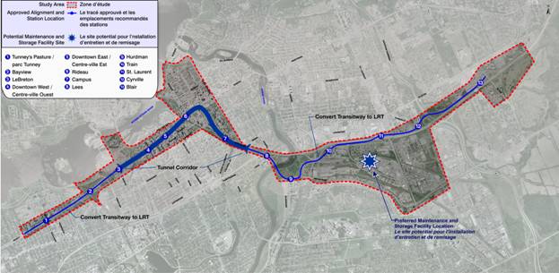
The new transit facility will see the construction of approximately 12.5 kilometres of new electrified light rail transit, between Tunney's Pasture and Blair Stations. Thirteen LRT stations have been identified along the proposed route. Each station will be designed to accommodate 180 metres long platforms (for future train lengths needed beyond the 2031 planning horizon). The tunnel will span approximately 3.2 kilometres with four stations below grade serving downtown and the University of Ottawa campus station.
East and west of the downtown tunnel the existing Transitway will be converted from bus rapid transit to light rail transit technology. Approximately nine kilometres of the alignment, outside of the tunnel portion of the corridor, account for conversion of the existing Transitway. The introduction of rail transit also requires the construction of a maintenance and vehicle storage facility in the vicinity of the LRT corridor at the eastern end of the system.
The general alignment and design of the stations are described
below. Figure 1 provides a general
overview of the stations within the corridor.
Figure 1- DOTT
Study Area and Alignment
Technology Report
The Rail System Selection Report was approved by Council on 25 November 2009, with the following recommendation:
·
That Transit Committee recommend that Council approve
that the Rail technology for the City’s Rapid Transit Plan be Light Rail
Transit (LRT).
Essentially the decision by Council for light rail will ensure that this and future light rail projects:
- Have less impact on the urban fabric and allows the ability to integrate both non-segregated and segregated systems;
- Provides the necessary capacity for the ridership predictions in the main core;
- Can accommodate low passenger capacity in the extensions outside of the main core;
- Has lower total system capital costs than Light Metro; and,
- Can accommodate Ottawa weather conditions.
The Planning and EA Process
The DOTT study is the City’s first project to follow the expedited maximum six-month EA process for transit projects. Ontario Regulation 231/08 came into effect in June 2008 and allows proponents to build upon past planning decisions to advance a transit project through an EA. In other words, with the Council-approved rapid transit network as described in the 2008 TMP and its supporting documents, major issues such as project need, corridor development (including surface versus tunnel), and technology assessment (such as buses versus trains) were thoroughly assessed through that planning exercise and do not have to be revisited in the development of the EA for the DOTT project. The Regulation also dispenses of the need for the study Terms of Reference, once a requirement for transit Individual EAs. This and the ability to refer to past planning decisions save considerable time and effort and allow environment-friendly transit projects to progress more quickly towards implementation than before.
The maximum six-month EA transit process is primarily for public consultation, documentation, and provincial approval of the Environmental Project Report (EPR). Once the EPR is submitted to the Ministry of the Environment, the approval period is 35 days (this is within the six-month timeline). If the Minister does not render a decision by the end of the 35th day, the project is considered approved. Should there be bump-up requests, the scope of those requests is now limited to matters of provincial interest only: natural environment; cultural heritage values or interests; and constitutionally protected aboriginal or treaty rights.
In developing Regulation 231/08, the Province assumes that the detailed
planning effort is completed resulting in a recommended solution before the EA
process is initiated. The results of the
detailed planning study for the DOTT project (i.e. the functional design) are
described in this report and the approval of Transit Committee and Council is
being sought.
It should be noted that the functional design constitutes the technical content to be included in the EPR. With Council’s approval of the functional design, staff will initiate the formal EA process to include final public consultation and the submission of the EPR to the Ministry of the Environment. Subject to unforeseen issues, no other report will be coming back to Council on the planning component of the DOTT project.
DISCUSSION
The need for the DOTT Study is
based on the acknowledgment that delays and congestion in the downtown area are
significant and of great concern when planning for the redevelopment of the
core area and meeting existing and future transportation needs of the City and
adjacent municipalities.
Transit
through downtown accommodates over 10000 riders per direction during peak
hours. Currently, transit service is
limited to approximately 180 buses an hour along Albert and Slater Streets
during peak times to meet travel demand.
Effectively, the transit system has reached its capacity in providing
Bus Rapid Transit service through the downtown to serve surrounding
communities. The system will no longer
be able to expand service beyond 2018.
The TMP aims to implement a series of initiatives whereby electrified light rail will:
·
Increase transit ridership and improve transportation
services throughout the region, and in particular, the downtown core area;
· Provide the transportation infrastructure
needed to support the City's projected population and employment levels for the
year 2031.
The most
significant initiative, and the subject of the DOTT study, is to:
· Construct a tunnel across downtown Ottawa;
· Convert the existing Transitway between
Tunney's Pasture and Blair Station from bus to rail technology.
As directed
by Council, light rail transit will follow the established Transitway route
between Tunney’s Pasture Station and Blair Station via a tunnel through the
downtown to replace the existing on-street downtown transit. The need for LRT has been established through
the TMP exercise and Council approved the choice of LRT technology on 25
November 2009 after consideration of this matter in an earlier report.
The Recommended Plan
The Recommended Plan for the DOTT project considers construction,
operational and maintenance issues in preparation of the design. Since the approval of the LRT alignment and
station options by Council, staff has worked to further define the alignment
and station designs, as well as develop project staging and costing
information. A detailed description of
the Recommended Plan is contained in Document 1. The following summary provides an overview of
the Recommended Plan, and focuses on specific areas where changes are
recommended to the alignment and station options approved by Council in May
2009.
Design Segments
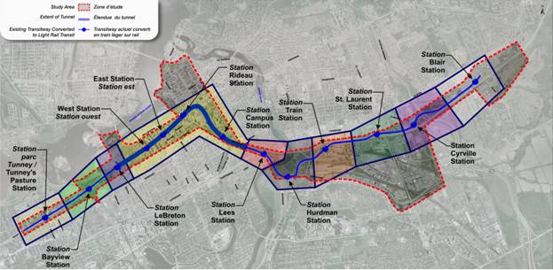
To comprehensively undertake this study, the project was divided into 10 design segments, described as follows and illustrated in Figure 2.
Figure 2- DOTT Design
Segments
Tunney’s Pasture
Station
Tunney’s Pasture Station will serve as the western terminus for the DOTT
and accommodate transfers from BRT service from the west and southwest until
such time that the LRT system is expanded further to Baseline Station in
accordance with the TMP (subject to a future Planning and Environmental
Assessment Study). The Station will
accommodate bus and rail transfers for approximately 9000 passengers per hour
during peak operating times. There will
be a need to have some transit continuing on Scott Street to facilitate
connections to the O-Train and Gatineau services at Bayview and LeBreton stations. Bus operation on Scott Street will be
minimized to mitigate the impact on adjacent lands and allow the federal campus
to proceed with its development initiatives.
Integration of the station with future PWGSC development plans for the
Tunney’s Pasture employment node can be accommodated. Once LRT is extended to Baseline Station and
the BRT transfer facilities are no longer required, these lands can be
re-purposed for development. The planned
underground pedestrian connection between the BRT and LRT platforms would
provide for direct access into any building located on this site.
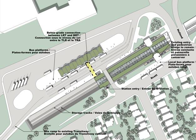
The recommended design for Tunney’s Pasture
follows the “Parallel” Design Option approved by Council in May 2009. This option converts the existing BRT
platforms in the Transitway trench to 120 m long LRT platforms in a
side-platform configuration. Protection
for future platform extension (to the east) to allow 180-metre long LRT
platforms is accommodated. A temporary
BRT terminal located on the north side of the existing Transitway corridor
would provide turn-around facilities for BRT buses and a waiting area for
passengers. This facility would be
reached via an existing (modified) bus ramp located to the west of the
station. Existing bus stop facilities
along Scott Street would remain to serve local service. Passenger flows between the BRT and LRT
platforms would be accommodated by an underground passageway extending from the
north LRT platform. To enable access to
the south LRT platform, an at-grade crossing of the tracks would be
permitted. This crossing would be beyond
the normal operating area of the LRT. Two storage tracks (120 metres long)
would be provided west of the LRT platforms to accommodate out of service
trains. Cross-over tracks would be
located to the east of the station to allow trains to be reverse direction at
this terminus station. An enclosed
platform canopy would cover the full length of the LRT platforms to protect
passengers from inclement weather and reduce on-going winter maintenance costs
(see Document 1 for more details). The
design of Tunney’s Pasture Station considers and seeks to accommodate the
Tunney’s Pasture master plan for redevelopment and future EAs such as the
Western LRT Corridor EA as described in the TMP.
Figure 3 – Tunney’s Pasture Station
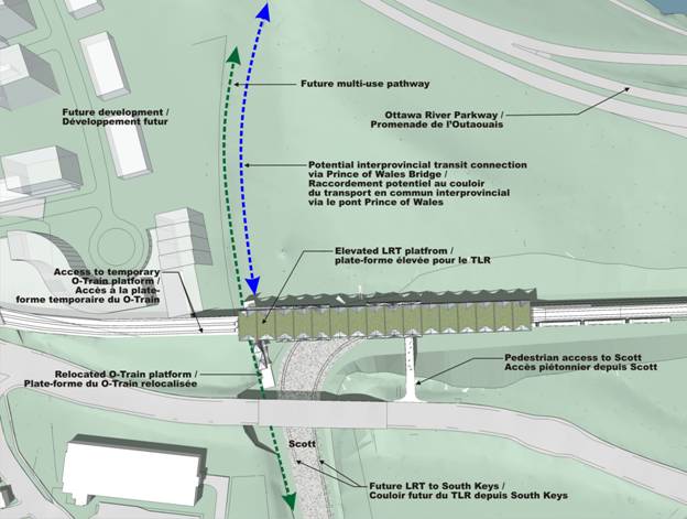
Bayview Station will be a transfer point between the DOTT and the
existing O-Train and a future expanded and electrified North-South LRT. Additionally, the design must consider the
potential for interprovincial transit service via the Prince of Wales
Bridge. As the station site is located
adjacent to the Bayview and Somerset Area redevelopment lands, potential
integration of the station design into future development is important. The alignment and new LRT station design
therefore seeks to maximize the development potential for lands adjacent to the
station that are in both public and private ownership. A concept plan for the City’s Bayview site
and the Bayview-Carling Community Development Plan have been considered in the
preparation of the recommended design to assure consistency with these
plans. Provision for a planned off-road
multi-use pathway to be located along the west side of the existing O-Train
corridor has also been considered in the design of Bayview Station.
LeBreton Station
will serve as a transfer point for OC Transpo bus service to/from
Gatineau. The station is located within
the NCC LeBreton Flats development lands and the LRT alignment through this
area follows the previous rapid transit alignment agreed to between the City
and NCC as part of the previous North-South LRT project. The station can be directly integrated into
future development on NCC lands and will also support development on the City’s
adjacent Escarpment Area development lands.
The LRT alignment east of LeBreton Station has been designed to maximize
the development potential of these lands by curving north under the former Wellington
Street right-of-way before entering the tunnel west of Bronson Avenue.
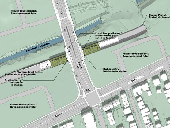
The recommended design for LeBreton Station follows the approved “Buses on Booth/Albert” design option. The configuration provides for a reconstructed Booth Street bridge spanning the existing aqueduct and the new LRT alignment above the station, which will have 120 metres LRT platforms in a centre-platform configuration, expandable to 180 metres long to accommodate six-car trains in the future. One station entrance located on each side of the new Booth Street bridge structure will be provided, with escalators, elevators and stairs giving access to the LRT platforms. Local bus platforms on Booth Street for northbound and southbound buses would be located on the upper level of the station. To accommodate bus operations at the Albert/Booth intersection, a widening to accommodate double left-turn lanes in the eastbound direction and a dedicated right-turn lane in the westbound direction is provided. All other lanes, and permitted turning movements, remain unchanged.
Figure 5: LeBreton
Downtown Transit Tunnel
Between LeBreton
and Mann Avenue, a tunnel will be constructed to replace the current on-street
bus lanes. This will separate rapid
transit from surface disruptions and provides capacity for future demand,
providing fast, efficient and reliable rapid transit through the downtown.
The tunnel through downtown Ottawa follows the approved “cross-country” alignment and includes the following major elements:
- West tunnel portal located east of LeBreton Station
o Tunnel Boring Machine (TBM) launch area will be an open cut between LeBreton Station and Bronson Avenue (for the duration of construction only)
o A standard poured-in-place concrete structure will be built in this area once TBM work is complete, to reinstate existing local roads and accommodate future development
- Four underground stations:
o Downtown West
o Downtown East
o Rideau
o Campus
- East tunnel portal located south of Mann Avenue.
Figure 6 – Downtown Overview
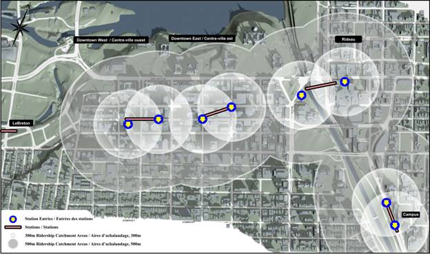
The rail corridor and configuration of the platforms in the downtown tunnel is based on the most efficient design to traverse the core. A centre platform, with an east and west bound LRT track on either side can be effectively and economically constructed as the tunnel boring machine (TBM) works its way through the limestone bedrock under the downtown area. The centre platform avoids duplication of stairways, escalators and elevators, thereby saving costs. This configuration also minimizes entrance and wayfinding requirements associated with other platform types. Supporting infrastructure and equipment needs are minimized and the platform creates a safer environment since there is a higher likelihood of multiple passengers at any given time and it is easier to secure the area in case of an emergency.
The tunnel’s
“cross-country” alignment is as follows:
·
Under Albert
Street, with the Downtown West station in the Lyon/Bay block;
·
Turning
slightly to the north at Bank Street to cross under Queen Street at O’Connor,
with the Downtown East Station centered between Bank Street and O’Connor; then
·
Continuing
cross-country toward Rideau Street, with a Rideau Station spanning under the
Canal and Rideau Street; then
·
Sweeping
to the south under Rideau, Waller and Nicholas to connect to Campus Station;
·
The tunnel
continues toward the portal located south of Mann Avenue and north of Lees
Station.
This
alignment is the most direct and cost efficient route for the tunnel. The alignment can be constructed easily, and
will have low on-going maintenance costs as the curvature of the track is
optimized. It services a large percentage
of the existing and potential development in the downtown, and is technically
the most feasible given geotechnical conditions and construction
considerations.
Four underground stations have been designed:
·
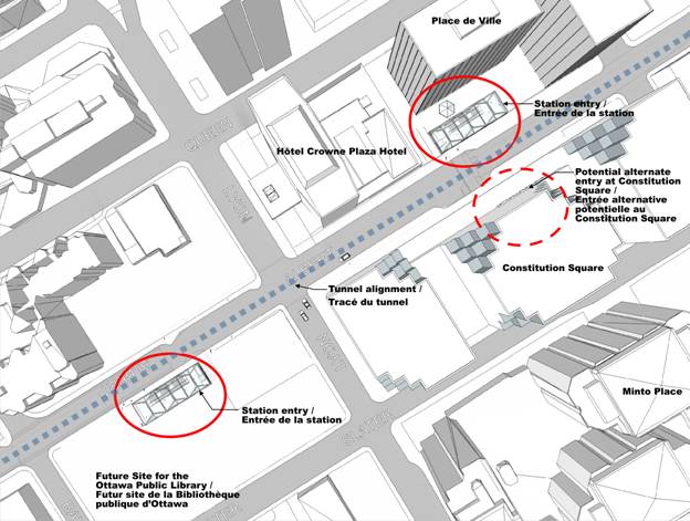
Downtown West Station is proposed to be located under Albert Street,
east of Bay Street, allowing integration with future Central Public Library
building and serves existing development in west end of downtown. An entrance into Place de Ville or
Constitution Square is also proposed.
·
The
recommended design follows the approved “Centre Platform” design alternative,
and incorporates:
o
180-metre
long centre platform, to accommodate four-car trains initially and six-car
trains in the future;
o
Two access
points from ground level:
§ South side of Albert between Bay and Lyon
(integrated into future Central Public Library site);
§ North side of Albert between Lyon and Kent
(integrated into Place de Ville office complex, or within public right-of-way
at existing Kent Transitway station);
o
Elevators,
escalators and stairs will be provided at each access point;
o
An
underground connection to the Constitution Square office complex or the
proposed development at the northwest corner of Albert and Lyon (existing
surface parking lot) could be constructed in the future, by others;
o
Underground
connections to other adjacent residential, office and retail development sites
could also be provided by others.
Figure 7 – Downtown West Station
·
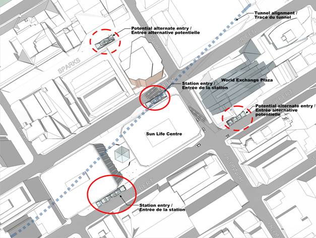
Downtown East Station is proposed to be located north of Albert
Street, between Bank Street and O'Connor Street, to provide connections to
local bus services on Bank Street and serves existing development in central
and east parts of downtown.
·
The recommended
design follows the approved “Centre Platform” design alternative, and
incorporates:
o
180-metre
long centre platform, to accommodate four-car trains initially and six-car
trains in the future;
o
Two access
points from ground level:
§ North side of Albert Street, east of Bank
Street (integrated into adjacent development or within the public right-of-way
at the existing Bank Transitway station);
§ South side of Queen Street at O'Connor Street
(integrated into adjacent development or within the public right-of-way);
o
Elevators,
escalators and stairs will be provided at each access point;
o
An
underground connection to the World Exchange office complex, Sparks Street and
other adjacent developments could be constructed by others in the future.
Figure 8 – Downtown East Station
·
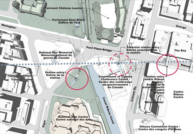
Rideau Station is proposed to be located south of Wellington
Street, between Confederation Square and Sussex Drive and has been designed to
provide connections to both the west and east sides of Rideau Canal. The design allows for potential integration
with the Government Conference Centre and the National Capital Commission
commemorative design initiative for the Rideau/Sussex intersection. Connections for local (OC Transpo) and
regional (STO) buses are also provided.
·
The
recommended design follows the approved “Centre Platform” design alternative,
and incorporates:
o
180-metre
long centre platform, to accommodate four-car trains initially and six-car
trains in the future;
o
Two access
points from ground level:
§ East side of the Plaza Bridge (west of the
canal and north of the National Arts Centre);
§ East of Sussex Drive (integrated into the
Rideau Centre and The Bay buildings);
o
Elevators,
escalators and stairs will be provided at each access point;
o
A
potential access point along the east side of the Government Conference Centre
(former Union Station) building could be constructed by others in the future.
Figure 9 – Rideau Station.
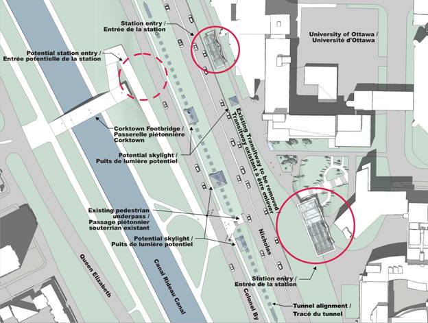
·
Campus Station is proposed to be located approximately where
the existing Campus Station sits today, and will provide connections to the
University of Ottawa, Sandy Hill and Golden Triangle (via the Corktown
Footbridge). The station alignment has
changed since the May 2009 report. The
station has been moved to the west side of Nicholas to improve constructability
and reduce the impact that construction will have on local traffic and Transitway
bus service (refer to Document 1). The
NCC is currently reviewing this new alignment and further consultation with the
Commission is required during the implementation/approval process.
·
The
recommended design generally follows the approved “South Portal, Underground
Station” design alternative, and incorporates:
o
180-metre
long centre platform, to accommodate four-car trains initially and six-car
trains in the future;
o
Two access
points from ground level:
§ North end of the station, adjacent to Vanier
Hall;
§ At the existing pedestrian underpass of
Nicholas Street;
o
Elevators,
escalators and stairs will be provided at each access point;
o
A
potential underground connection into the new Vanier Hall building could be
constructed in the future, by others.
Figure 10 – Campus Station
This report
recommends that staff be directed to undertake an urban design study and a
transportation study for the downtown for post DOTT implementation. Due to the re-purposing of Albert and Slater
Streets and the impact of reduced bus traffic through the core area, it is
appropriate that these studies be undertaken to determine the aesthetics and
operational aspects of downtown streets, the ability to accommodate cycling
lanes and improve pedestrian circulation and safety. Similarly, the streetscape component of the
core area should be examined in the context of new opportunities due to the
changes that will occur in traffic patterns and the geometric alignment of
streets, particularly Albert and Slater Streets.
Lees Station
Lees Station serves
adjacent residential development to the south and east of the station area, as
well as the southern part of the Sandy Hill community. The station has the potential to be
integrated into redevelopment of adjacent lands as envisaged in the
Nicholas-Mann Gateway Precinct Design Plan, and also future redevelopment of
University of Ottawa lands to the south.
An important existing pedestrian link between Lees Avenue and the main
University of Ottawa campus will also be maintained.
Following the
approved design option for this segment of the alignment, Lees Station will
remain in its current location and generation configuration, with upgrades to
existing station facilities incorporated as part of conversion to LRT. This includes provision of 120-metre long
LRT platforms, with protection allowed for future extension to provide
180-metre long platforms. The existing
platform canopies will be removed and replaced with a new fully enclosed
platform canopy spanning over the LRT tracks.
Due to the lower use nature of this station, the platform canopy may not
extend for the full length of the LRT platforms. Existing station access points from Lees
Avenue will be maintained.
Figure 11 –
Lees Station
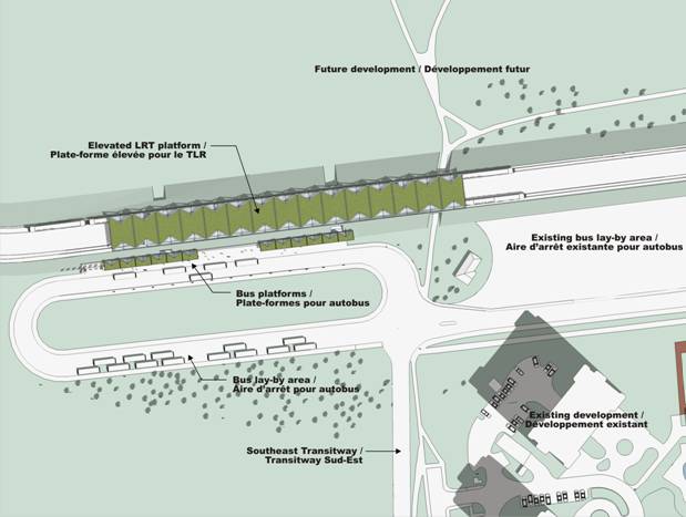
Hurdman Station
Hurdman Station will be a major transfer point between the DOTT and the
existing Southeast Transitway as well as local bus services. There is a significant opportunity to
integrate the station with future development lands to the north owned by the
NCC, with access provided to these lands via an extension of Industrial Drive,
passing under the DOTT corridor to the east of the station. Important pedestrian and cycling linkages
around the station area will be maintained to provide connections to/from and
through the station area.
The recommended design for Hurdman Station follows the
approved “Horizontal Transfer – Further North” design option. This will allow continued bus operation to
continue to serve the existing station platforms through most of the
construction period. This option places the LRT platforms on a
raised embankment north of the existing station, and reconfigures the bus loop
as a one-sided platform parallel to the LRT, in an arrangement similar to
Billings Bridge Station. Underpass
structures will provide access from the BRT platforms to the raised LRT
platforms, and also provide through connections to the development lands and
pathways north of the station. 120-metre
LRT platforms in a centre-platform configuration, expandable to 180-metre long
LRT platforms to accommodate six-car trains in the future will be
provided. A pocket track will be
provided to the east of the station to provide operational flexibility for LRT
service. After construction, the
existing centre-island bus platform will be demolished, with the space
converted to provide bus lay-up and turn-around facilities. The existing bus lay-up space to the east of
the station could be re-purposed for other uses, such as an enhanced drop-off
facility.
The NCC intends to
develop lands to the north of Hurdman Station and therefore an appropriate
access to the site is required. This
will be achieved by extending the elevated LRT alignment further east, to pass
over an extended Industrial Avenue, which will serve the development parcel in
the future. This elevated alignment will
meet the existing Transitway alignment and grade east of Hurdman Station and
pass over Riverside Drive via the existing Transitway overpass.
Figure 12 – Hurdman Station
Train Station
Train Station provides important connections to intercity (VIA)
passenger rail service and to potential commuter rail service. Access to adjacent employment lands to the
east is also provided, and potential integration with a planned Queensway
pedestrian overpass can be provided, allowing for access to development on the
north side of the Queensway (Baseball Stadium, Overbrook community). Existing pedestrian and cycling connections
to the east and west would be maintained.
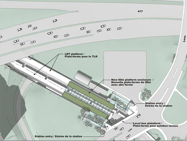
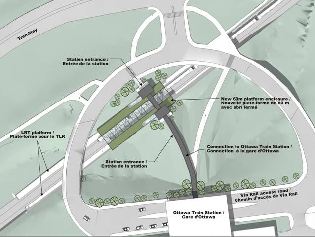
The recommended design for Train Station follows the approved “Diagonal” design option. This option eliminates the existing sharp curves east of the station, which are not suitable for LRT operation and straightens the alignment in front of the station. The existing BRT platforms, Tremblay Road and east station driveway overpass structures would be demolished, with new LRT platforms and overpass structures built along the new alignment. The existing west station driveway can be maintained, which will allow access into the VIA rail station to be maintained during construction. 120-metre LRT platforms in a side-platform configuration, expandable to 180-metre long LRT platforms to accommodate six-car trains in the future would be provided. One access point located approximately at the mid-point of the LRT platforms would be provided, linking the LRT station with the VIA rail station and Tremblay Road via a covered walkway. It is proposed that the existing pedestrian bridge spanning the Transitway be relocated and re-used to span the LRT tracks at the access point. Others could construct a future connection from the east end of the LRT platforms. Elevators, escalators and stairs would provide access between ground level and the LRT platforms, located within the existing “bowl” in front of the VIA rail station.
Figure 13 - Train
St. Laurent Station
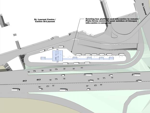
St. Laurent Station serves an established major retail development (St. Laurent Shopping Centre) and provides for transfers to local bus services via an upper level bus terminal. The adjacent shopping centre has submitted plans for a major expansion, which will further support transit ridership. Additionally, PWGSC is preparing development plans for a major employment node located on lands adjacent to the station site, south of The Queensway. There is the potential for a direct pedestrian connection from these lands into St. Laurent Station.
Following the approved design option for this segment of the alignment, St. Laurent Station will remain in its current location and general configuration, with upgrades to existing station facilities incorporated as part of conversion to LRT. This includes provision of 120-metre long LRT platforms on the existing lower level of the station, with protection allowed for future extension to provide 180-metre long platforms. The upper level bus platforms would remain largely unchanged and continue to serve local bus services providing connections to the LRT line. Existing station access points will be maintained, with the potential for a connection to future development lands south of the Queensway (to be built by others).
Figure 14 – St.
Laurent Station
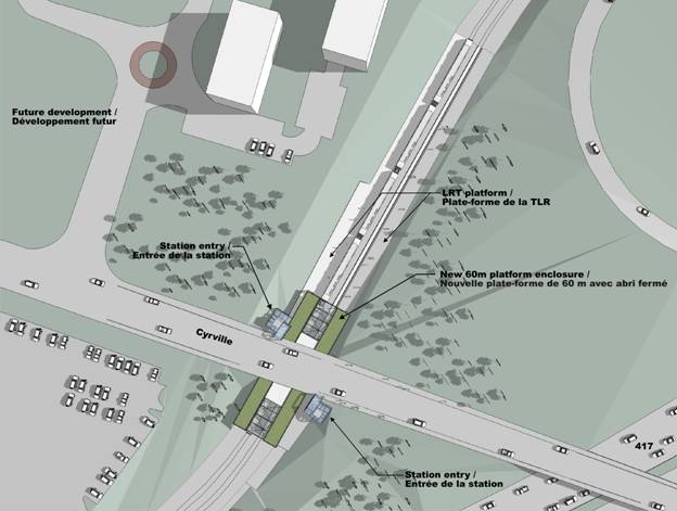
Cyrville Station
Following the
approved design option for this segment of the alignment, Cyrville Station will
remain in its current location and generation configuration, with upgrades to
existing station facilities incorporated as part of conversion to LRT. This includes provision of 120-metre long
LRT platforms, with protection allowed for future extension to provide
180-metre long platforms. The existing
platform canopies will be removed and replaced with a new fully enclosed
platform canopy spanning over the LRT tracks.
Due to the lower use nature of this station, the platform canopy may not
extend for the full length of the LRT platforms. Existing station access points from Cyrville
Road and an office development to the west will be maintained.
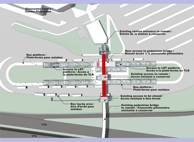
Blair Station
Blair Station will serve as the eastern terminus of the DOTT and accommodate transfers from BRT service from the east (existing East Transitway and future Cumberland Transitway) and local bus services. The station also serves a major retail development (Gloucester Centre) located immediately adjacent to the station site, as well as office developments to the east and south (linked via a pedestrian bridge over OR 174).
The recommended
design for Blair Station follows the approved “LRT on Lower Level” design
option. This option converts the
existing local bus platforms on the lower level of the station to 180-metre
long LRT platforms, in a centre platform configuration, to accommodate four-car
trains initially and six-car trains in the future. An expanded upper level bus platform in a
centre-island configuration would accommodate BRT and local bus service, with
vertical transfers achieved directly from the upper (bus) to lower (LRT)
levels. The existing pedestrian
overpass, which spans over the station and connects the Gloucester Centre to
development lands on the south side of OR 174, would be rehabilitated and
re-used. Existing station access points
into the station would be maintained. A
cross-over track would be provided to the west of the LRT platforms to allow
trains to reverse direction. A pocket
track, also to the west of the station would be provided to store out of
service trains and provide operational flexibility.
Figure 16 – Blair Station
Maintenance and Storage Facility
The LRT Maintenance and
Storage Facility is included within the scope of DOTT Planning and
Environmental Assessment Study and is an integral part of the project, as it
will:
- House
and service all of the trains needed to operate the line;
- Service
vehicles to be used on future LRT lines;
- House
the operations control centre (signalling, communications) for the line;
and,
- Be
the primary heavy maintenance facility for the LRT network.
Ten potential
sites were examined based on the four evaluation factors developed for the
facility, namely:
- Site
Characteristics (topography, grade, land use compatibility, expansion
capability and environmental considerations);
- Facility
Operations (turnaround loops, track redundancy, layout efficiency and
municipal services);
- System
Operations (connectivity to the line, efficiency and access to freight
rail); and,
- Relative
Costs (capital, operating, maintenance and property ownership and
acquisition).
Evaluation of the 10 candidate
sites was presented at DOTT Public Open House #2 on 24 June 2009. Based on the evaluation, three sites were
short-listed for additional evaluation:
- Bayview;
- Hurdman North;
- St. Laurent.
Based on feedback from the
Consultation Groups and the public, additional evaluation was undertaken,
focussing on the land use and development impacts of the three sites. While these factors had been considered in
the initial evaluation, the number of technical considerations overshadowed
these impacts. As the three short-listed
sites were all capable of supporting the facility from a technical perspective,
the focus on land use and development was deemed the primary
differentiator. As a result of this
additional analysis the St. Laurent site is recommended as the preferred site
based primarily on:
- Land use;
- Ownership;
- Expansion capability;
- Access and connectivity to Transitway.
Document 1 describes the
location and the recommended plan for the Maintenance and Storage
Facility. This facility needs to be
constructed and ready to accept vehicles, in advance of the revenue service,
for the commissioning of the line.
Geotechnical Analysis
A geotechnical study was carried out in support of the planning and functional design phase of this project. Published information and maps from the Geological Service of Canada and the Ontario Geological Service, as well as subsurface information from the geotechnical consultant’s (Golder Associates) files, were used as the basis for that geotechnical study.
The results of the study indicate that most of the route downtown is underlain by shallow bedrock, likely at depths ranging from about two metres to five metres below existing ground surface between the west portal and Rideau Centre area. In the vicinity of the Rideau Centre, a valley in the rock is known to exist, where the surface of the bedrock is indicated to be locally much deeper. South of Laurier Avenue, the bedrock becomes progressively deeper, extending to depths ranging from about five metres to possibly 25 metres below existing ground surface, and changes from limestone to shale of the Carlsbad formation. The subsurface conditions from about Waller Street to Mann Avenue likely consist of sensitive silty clay overlying deposits of glacial till and sand, and south of Mann Avenue the subsurface conditions are indicated to consist of significant deposits of sands underlain by glacial till. Both of these areas will have substantial groundwater issues. In addition, the published information indicates that at least three faults cross the tunnel alignment in the downtown core. Additional faults and associated tributary faults likely also lie within the study area. These faults are now considered inactive but create important features likely to impact the overall bedrock quality and hydrogeological regime.
A sample of rock from a local quarry was sent to a laboratory for testing to confirm some of the parameters used for design. While generally useful, this sample only provided guidance in setting parameters.
The results of the
geotechnical study have been used to inform the functional design of the tunnel
and downtown stations. Based on the
results of preliminary rock modelling using the data available, the vertical
alignment of the tunnel has been lowered to provide additional clearance from
structures above. The position of Rideau
Station has also been shifted further to the west in order to be located
outside of the rock valley area.
In order to advance
the design of the tunnel and underground stations, additional analysis of rock
conditions is required to support the next phase of project design. This work would include drilling boreholes
and undertaking more detailed testing and analysis of geotechnical and
hydro-geological conditions.
Construction Staging
While the final construction
staging plan for the DOTT project will be the responsibility of the
implementation team and the contractor selected to construct the system, the DOTT
functional design process did look at the general objectives of the staging and
opportunities to provide logical break points between sections and phases of
work. Estimated durations were also
compiled to allow for schematic planning of the implementation process. At the most general level, the project will
be staged to:
- Minimize construction
cost;
- Minimize traffic and bus service disruption;
- Optimize cash flow; and,
- Maximize contractor efficiency.
The staging will also follow
these general principles:
- The tunnel and underground
stations will likely start first, as these elements will take the longest
to construct;
- The Maintenance and
Storage Facility must be completed midway through the construction of the
project to allow for delivery of vehicles and vehicle testing;
- Major work at Bayview,
Hurdman and Blair is off the existing Transitway and can be done with
minimal disruption to bus service;
- Conversion of the
Transitway will be done in logical segments to maintain bus service on the
Transitway for as long as possible;
- Once construction starts
in an area, bus service will be rerouted, and will not return; and,
- After construction is
complete there will be a period for station fit-out, testing and
commissioning before revenue service starts.
In
addition to the general principles, the following assumptions were made to
determine construction staging opportunities, estimate duration and estimate
capital cost for the tunnelled portion of the project:
- The twin tunnels will be
constructed using a Tunnel Boring Machine (TBM), likely an Earth Pressure
Balance machine, which will allow the tunnel work to proceed from end to
end through the varying ground conditions that are known to exist;
- The tunnels will be staged
from LeBreton Flats to take advantage of vacant land;
- The depth of the tunnel
(approximately 30 to 35 metres below grade) has been planned to avoid
impacts to building foundations, utilities and the Rideau Canal;
- Cut and cover construction
will generally be limited to the areas around the west and east tunnel
portals;
- There will be some visible
cut and cover construction work at each station to construct the entrances
and vent shafts (some locations which are not under the travel lanes, or
which can be closed off may be constructed using open excavations, where
local conditions permit);
- Downtown stations will be
mined out from within the tunnels, and all of the excavated material will
be hauled out to the LeBreton work site; and,
- Campus Station will be
constructed using the traditional open excavation method.
The bulk of the visible
activity will be at the TBM launch site, which will be at the east end of the
LeBreton Flats, although there will be substantial activity at Campus Station
and the East Portal (south of Mann Avenue).
Appropriate mitigation measures to reduce noise level impacts during
construction will be considered during the EA phase of the study, with detailed
plans developed by the contractor responsible for actually constructing the
tunnel. The City will have input into
specific measures adopted (e.g. working hours, truck routes, dust control).
The
following assumptions were made to determine construction staging
opportunities, estimate duration and estimate capital cost for the conversion of Transitway Stations:
- Platforms will be widened
with the tracks being placed in centre by-pass lanes;
- Existing canopies and
shelters will be removed;
- Elevators will be
upgraded; and,
- New canopies will be
installed over the platforms and track for the full length of the station
(except at a few low-use stations).
The stations at Bayview,
LeBreton, Hurdman, Train and Blair require extensive modifications to
accommodate conversion and must be largely rebuilt to accommodate the new LRT
system and the transfer of passengers to bus and Transitway services.
The following assumptions were
made to determine construction staging opportunities, estimate duration and
estimate capital cost for the conversion of the Transitway running segments
(between the stations):
- In open areas, ballast and
track will be installed on top of the existing roadway;
- Track through the stations
will be directly fixed to a concrete slab for ease of maintenance;
- Minor changes to drainage
will be required; and,
- Some structures will
require modifications to increase vertical clearances.
An operating plan for
the line was required to develop the functional plan. The following assumptions were used to
develop the physical requirements for rail operations:
- Track, power and systems
installation at the Maintenance and Storage Facility will be completed
before the vehicles arrive;
- Testing in the yard and
sections of the line close to the Maintenance and Storage;
- Facility construction will
begin as soon as possible;
- Each section of track that
is completed will require a testing and commissioning period;
- Crossovers will be
provided at the terminus stations and at key points along the line to
allow trains to reverse direction;
- Pocket tracks will be
provided at Hurdman and Blair Stations;
- Two storage tracks will be
provided at Tunney's Pasture to accommodate out of service or disabled
trains; and
- The connection to the
Maintenance and Storage facility will allow trains to enter/leave the line
from both directions.
High-level project
scheduling indicates that it could take up to seven years for construction and
commissioning of the LRT line. This
duration estimate is subject to refinement through design and the procurement
process. A report will be forwarded to
Council to outline the implementation/construction of the project when a
procurement method is established.
Bus Operations During and After Construction were
also a major consideration in the development of the functional plan, although
the actual bus operating plans will need further review during the detailed
planning of the station and the bus network that is put in place after
construction will need to reflect the ridership patterns in place at that
time. However, there are several
assumptions that were made to determine the impact of construction on bus
services and to size the bus transfer facilities included in the functional
plan. The DOTT project assumed that various segments of the Transitway will be out of service
as construction proceeds, during which alternative arrangements will be needed,
including:
- Use of the shoulder or
outside lane of the Queensway;
- Dedication of traffic
lanes to transit usage along some streets;
- Implementation of traffic
signal priority along key routes;
- Minor reconfiguration of
intersections and interchanges, to give buses priority;
- Potential major
reconfiguration of the Nicholas interchange and access to Lees Avenue to
reduce impacts on vehicular circulation and to prioritize bus movements to
and from the core area via Nicholas;
- Several alternate routes
will be required, likely including:
- Innes, Industrial,
Ogilvie, Coventry, Tremblay, Riverside and the Queensway in the east;
- The Queensway, Carling,
Scott/Albert and the Ottawa River Parkway in the west;
- Bus routes may be
segregated into local and express services and assigned to different
routes to minimize local impacts.
Transit Services also undertook a strategic plan
(conceptual plan) for bus connections with the rail line for the areas around
the Rideau Centre, at downtown rail stations, Tunney’s Pasture, Hurdman, St.
Laurent, and Blair. This is detailed in
a separate report (IPD – Strategic Plan for Bus Route Connections with Rail
Line. Ref: ACS2009-ICS-TRA-0013).
During the detailed design
phase, the final detour plans will be closely co-ordinated with construction
staging. These plans may include
temporary station facilities to provide good connectivity to local routes and major
trip origins and destinations, for instance if buses serving St. Laurent
Station are by-passing the existing station, expanded bus bays may be required
on St. Laurent to facilitate transfers.
At the end of the construction
period, there will be substantial changes to the existing BRT and local bus
routes to provide connections with the new LRT line, reflect the new operating
philosophy, respond to ridership growth and changes in ridership patterns and
meet the operating budget requirements in place at the time.
Figure 18(a) – Bus Diversion Routes

Figure 18(b) – Bus Diversion Routes
Property Requirements
The functional design exercise has determined the land requirements based on the alignment for the Recommended Plan. Lands in both the private and public domain are required. Real Estate Services has established that 130 properties are needed for this project, as follows.
- 50
owned by the City of Ottawa;
- 50
owned by the federal government and agencies, and the National Capital
Commission (NCC.), including approximately;
o 30 owned by the
NCC
o 15 owned by
Public Works
o 5 owned by
federal agencies
- 10
owned by the provincial government and agencies;
- 20
owned by private owners, including approximately;
o 15 with
subterranean rights
o 5 with surface
rights
Property requirements are a key component of the implementation plan and direction to staff is needed to begin the real estate transaction process to ensure that land can be secured, and the proper sequence of construction staging is possible to minimize disruption of traffic and property. This is particularly important for the alignment west and east of the tunnel. The tunnel requirements for lands will focus on the downtown core requirements for property, easements, subterranean rights and staging areas.
Business Case
The Business Case document is not part of the functional planning or environmental assessment requirements, but is intended to fulfill the information requirements of senior levels of government associated with funding major transit projects. The content consists of a detailed project description, a statement of the project's benefits including an analysis of the project's measurable results, and a series of specific information items relative to government priorities.
With a Recommended Plan defined, the business case for the Ottawa DOTT is now actively underway. The analysis of the project's results is being conducted using a Multiple Account Evaluation framework, which has allowed other project benefits to be calculated. The ridership is being refined and transportation impact information is being developed at time of writing and will be added to the business case. This analysis is expected to be completed by end of January 2010 and will be forwarded to Council for information.
Public Art
Public art is an important component of the project and will be accommodated within station and runningway elements of the system. The City of Ottawa has a policy requiring that an amount equal to one per cent of an infrastructure project’s hard costs be dedicated to the provision of public art. An allowance of $10 million has therefore been included in project costing for public art. In addition to the provision of stand-alone pieces of artwork throughout the system, public art could also be integrated into the architectural elements of stations and runningways. Existing public art along the Transitway will be maintained wherever possible.
A public art program geared
specifically for this project will be developed by the City and include input
from a number of groups including the NCC, Algonquins of Ontario, local arts
interest groups and the community at large.
Next Steps –
Overview
The approval of the Recommended Plan outlined in Document 1 and the recommendations presented for approval in this report will lead to a number of activities over the next several months. A critical path has been provided to Council and will be updated from time-to-time, as milestones are set. While the DOTT EA (Provincial process) is expected to be approved by the Minister in May 2010, the Federal EA process, which requires more design details, will continue and is expected to be complete in early 2011.
An overview of the next steps in the roll-out of this project, leading to contract award is as follows:
Planning and EA:
13 January 2010 - Recommended Plan (functional design) to Council for approval
January/February 2010 - Notice of EA Commencement, including final consultation
Early March 2010 - Notice of EA Completion, EPR available for public review
Early April 2010 - Deadline for public comments on the EPR
Early May 2010 - Ministry of Environment Decision on the DOTT EA
It is importation to note that the City has undertaken an update of the risk assessment of the TMP as it relates to the DOTT project and also worked with Infrastructure Ontario to assess the merits of an alternate financing procurement (AFP) method. Analysis of the assessment is underway and will be the subject of a report on procurement of DOTT to Transit Committee and Council in the new year.
RURAL IMPLICATIONS
N/A
CONSULTATION
This study involved over 150
stakeholder groups, including community organizations, property owners and
businesses within the study area, institutions, approval agencies and groups
with a special interest in the study. In
addition to the Agency, Business and Public Consultation Group meetings, three
Public Open Houses and presentations were conducted in February, June and
October 2009. More than 300 people
attended in total. The City has received
over 150 comments from the open houses which supplements approximately 100
comments on the project that have been received to-date in the form of written
submissions or email from the project web-site.
Individual meetings were also arranged with groups
such as the Downtown Coalition, Viking Rideau Corporation, the University of
Ottawa, and the NCC. A project website
(www.ottawa.ca/tunnel) was established along with a dedicated e-mail address (dott@ottawa.ca) to allow the public to contact
the study team directly. Consultation
efforts will continue as the study progresses through the EA stage.
A summary of consultation efforts undertaken to date
is provided in Document 2.
Issues Arising From
Consultations
National Capital Commission
The National Capital Commission (NCC) has a mandate
and mission to build the Capital region into a source of pride and unity for
Canadians. They play a key role in the
project as they have land holdings at a number of stations, along the alignment
and a special interest in the planning of the core area of the City. The NCC also grants applications for federal
land use approvals.
A number of meetings have been held with the NCC to
deal with real estate issues, land use and design, and other matters that fall
within their mandate and require permits and approvals. These matters have been assessed in the
context of this planning exercise and have been incorporated in the Recommended
Plan. Further collaboration with the NCC
is required to initiate the formal approval process and this will be achieved
as the project moves forward with design.
Some key issues being dealt with include:
· Interim and ultimate bus operations and proposed BRT to LRT transfers areas;
· Proposed future modifications to interprovincial STO bus service routes on Ottawa side;
· Design principles and guidelines which have considered the capital perspective and National Symbols (Parliament, confederation boulevard, UNESCO site, etc);
· Transit-oriented land use design principles for stations located on future development lands;
· Ridership projections and future interprovincial transit considerations;
· Details on the federal land requirements (for both the NCC and other federal agencies and departments);
· Assessment of the effects of construction and implementation of LRT service on the environment, heritage/UNESCO Rideau Canal and proposed mitigation at federal sites in proximity to the national symbols, large commemorative sites and Parliament;
· Detailed information on the station design (dimensions, geometry, land requirements, etc) for stations where there is a capital interest; and,
· Business case (justification) for federal land use.
In addition, presentations to NCC’s Advisory Committee of Planning Design and Property (ACPDR) requires regular presentations and updates related to:
· Design Principles;
· Integration of Transportation and Land Use;
· Details of Station layout and Storage and maintenance Facility;
· Urban Design and Landscape; and,
· A transit System for the people; and,
· Federal EA process.
The Downtown Coalition sought a cross-country
alternative that would move the alignment southerly under Albert Street before
veering at Metcalfe Street towards Rideau Station. This matter has been
discussed with the Coalition in detail and the recommended plan is now
supported by the Coalition. It is now
agreed that the recommended plan achieves the following:
· Less tunnelling due to a more
direct route to the next station;
· Less costly due to a shorter
route and less technically challenging boring strategy;
· Optimal walking distance to
the station;
· Does not require an “S” curve
to reach Rideau Station;
· Provides the potential for
more access points to the surface;
· Avoids technically
difficulties under and around buildings;
· Provides a smoother more
comfortable ride through the core; and,
· Will require less maintenance
on vehicles (wheels).
Rideau Station and Rideau Viking Corporation
The Viking Rideau Corporation indicated that the
recommended plan would not be suitable for the operation and future growth of
the shopping complex and its remaining development parcels since primary
transit movements would be focused at the Rideau Street end only, rather than
distributed between Rideau Street and Mackenzie King Bridge as currently
exists. Transit Services has undertaken a
review of bus and passenger routings in the area and summarized findings in a
separate report (IPD – Strategic Plan for Bus Route Connections with Rail Line.
Ref: ACS2009-ICS-TRA-0013). The report concludes that:
·
Routings in the vicinity of the Rideau Centre can be modified to balance
the interests of transit customers, operations staff and the Rideau Centre;
·
Changes to the routings will help reallocate buses to the streets in
downtown in a manner consistent with balancing service on available streets;
and,
·
Performance of the routes, both in terms of costs and passengers
carries, will remain very similar to the current operations.
The recommended tunnel alignment at Rideau Station
serves multiple purposes, including facilitating local transit connections with
direct and indirect access to the By-Ward Market, Rideau Centre and retail on
Rideau Street, the Ottawa Conference Centre and the National Arts Centre and
Confederation Square.
This station location best suits the LRT alignment
from a functional and operational perspective. Local and regional transit
will be well served by the station as it will act as a hub for riders destined
to this area of the downtown. The number
of above-grade transfers and reduced travel time because of a more direct
transition between local and regional traffic as well as the opportunity to
transfer to local routes at other stations along the LRT network will make this
a very active station.
Public Consultations
Extensive consultation has been undertaken throughout
the study. The consultation effort is
summarized in Document 2 – Summary of Public Consultations.
There is strong public support for this project. Major issues received from the public and
special interest groups arising from the recent Public Open House #3 (26
October 2009) include:
Transit
Link to Gatineau
The issue of a transit link to Gatineau from Ottawa, and specifically from Bayview, was raised. This DOTT project does not preclude the development of an interprovincial transit link or transfer at Bayview, nor any other option. The infrastructure required to integrate interprovincial transit services is the subject of the Interprovincial Core Area Rapid Transit Integration Strategic Planning Study (a joint study with the STO/Gatineau, the NCC (project lead) and the City of Ottawa). The interprovincial transit study addresses both short-term and long-term solutions (operational improvements/coordination, and possibly new infrastructure). Options from that study will be presented for public review in early 2010, with an anticipated report to Transit Committee by mid 2010.
Tunnel Depth and Access To
Grade
There were
concerns that the tunnel is too deep and comments concerning the accesses
to/from the underground stations. This
issue has been discussed at consultation meetings and again at the most recent
open house. As stated earlier in this
report the Recommended Plan includes two entrance points at each station (there
are options for additional connections that can be provided by others). Stairs and escalators will be provided at
each entrance. There will be back-up
emergency power. The tunnels have to be
at a depth that clears underground utilities and parking garages but more
importantly it should be in solid bedrock to ease the construction effort,
duration, and risks. The depth of the
tunnel will be re-examined at the next phase of design, which will be supported
by additional geotechnical investigations such as borehole testing. With the current plan, the estimated time to
access the platform from street level varies depending on the station and the
access point chosen. However, the few
minutes that it takes to access the underground platform can be quickly offset
by the reliability and frequency of a grade-separated LRT service with headways
of approximately two minutes or less. A
discussion of utility relocation to accommodate construction of the tunnel and
above grade trackwork and stations is provided in Document 1.
Number of Downtown Stations
This issue was raised
previously in May 2009 when Council deliberated and approved the DOTT alignment
and station locations. There are four
underground stations planned to serve downtown Ottawa: Downtown West,
Downtown East, Rideau and Campus. LeBreton Station, to the west of the
core area will also serve development on the west side of downtown, including
the proposed Escarpment Area development. Comments received during the
consultation process have indicated a desire for either more, or fewer stations
in the downtown Ottawa. Those advocating more stations have typically
expressed concern over the spacing between downtown stations compared to other
cities, the catchment area of each station, and the distance required to access
each station given the potentially deep level of the tunnel. Others
advocating fewer stations for the downtown identify vehicle travel time and
cost savings as concerns.
Using a benchmark of 300-metre
and 500-metre walking distances, it was demonstrated that the majority of the
downtown area was within the catchment area of a station, as measured from the
mid-point of the platform area. Separate access points from the platform
level helps lessen the walking distance and travel time to the station.
Walking distances are consistent with the City’s guidelines for walking
distances to transit stations.
Overall, the proposed number
of stations serving the downtown area has struck a balance between optimal
station spacing for transit vehicle performance and in-vehicle travel time and
the need to provide access and coverage to the downtown area. This
practice is consistent with other successful transit systems in other
cities. Given the significant cost of
constructing underground stations, provision of additional stations in the
downtown is not recommended.
COMMENTS BY THE
WARD COUNCILLOR(S)
N/A
LEGAL/RISK MANAGEMENT IMPLICATIONS
There are no
legal/risk management impediments to implementing this report's recommendations.
CITY STRATEGIC PLAN
The recommendations contained herein directly and indirectly support the following objectives of the Strategic Plan.
A1. Improve the City’s transportation network to afford ease of mobility, keep pace with growth, reduce congestion and work towards modal split targets.
B1. Attain transit goals (30% modal split) by 2021.
E6. Require walking, transit and cycling oriented communities and employment centres.
F2. Respect the existing urban fabric, neighbourhood form and the limits of existing hard services, so that new growth is integrated seamlessly with established communities.
F4. Ensure that City infrastructure required for new growth is built or improved as needed to serve the growth.
TECHNICAL
IMPLICATIONS
N/A
FINANCIAL
IMPLICATIONS
Detailed costing of
the recommended plan includes an estimate for property acquisition, design,
project management, construction, vehicles, and contingency. The capital cost estimate for this project is
$2.1B, in 2009 dollars. The following is
a summary of the major cost elements of the project:
·
Transit
Tunnel and Underground Stations $735 million
·
Transitway
to LRT Conversion $540
million
·
Maintenance
and Storage Facility and Vehicles $515
million
·
Property,
Public Art, Insurance $160
million
·
Project
Director's Contingency $100
million
·
Project
Office $ 50 million
This project estimate does not include
escalation, and is subject to refinement as the project progresses through
subsequent design phases, such as preliminary engineering and approval of
a procurement model.
In a memo dated 23 October 2009 to the Mayor and members of Council from the Deputy City Manager and City Treasurer, the affordability of the DOTT project (as well as other rapid transit projects identified in Phase 1 of the TMP) was outlined. It was concluded that the City has the financial capacity to afford its share of all Phase 1 projects in accordance with the City's Fiscal Framework. The affordability model assumes that the two upper-tier levels of government will each contribute one-third of the total project costs. Once a preliminary agreement has been reached with our funding partners a subsequent report will be provided to Committee and Council for approval.
The draft 2010 budget includes a funding request of $74.3M in account 905176 LRT (Tunney's to Blair) to initiate property acquisition, preliminary engineering and procurement management. This allows the DOTT project to move forward from the planning/EA phase to implementation as quickly as possible.
Funding for the urban design study and downtown
transportation study (post DOTT implementation) are available in existing
transportation study accounts - 902973 Smart Growth Transit EAs, and 905184 Rapid Transit EAs.
SUPPORTING DOCUMENTATION
Document 1 Functional Design of Recommended Plan (Previously distributed and held on file with the City Clerk)
Document 2 Summary of Consultations
Document 3 Transit Plan Critical Path
DISPOSITION
Following
Committee and Council approval of the recommendations contained herein,
Infrastructure Services and Community Sustainability will undertake the
following:
·
The formal
Environmental Assessment (EA) process using the functional design to define the
undertaking and file the Environmental Project Report with the Ministry of the
Environment in accordance with Ontario EA Regulation 231/08 for transit
projects.
·
Initiate the property
acquisition process, subject to the 2010 capital funding request.
· Initiate the preliminary engineering process, procurement management process, and property acquisition process.
· Undertake an urban design study and a transportation study for the downtown core area for post DOTT implementation.
SUMMARY
OF PUBLIC CONSULTATIONS DOCUMENT 2
Downtown Ottawa Transit Tunnel: Tunney’s Pasture to Blair via a Downtown
LRT Tunnel
|
||
Chronology of Consultation Meetings
|
||
|
Date |
Consultation Type |
Purpose |
|
13-Aug-08 |
CEAA, MOE Co-ordination Meeting |
Project introduction and EA
co-ordination |
|
21-Aug-08 |
ACPDR #1 |
Project introduction and
overview |
|
09-Sep-08 |
ACG #1 |
Project introduction and
overview |
|
09-Sep-08 |
BCG #1 |
Project introduction and
overview |
|
09-Sep-08 |
PCG #1 |
Project introduction and
overview |
|
29-Oct-08 |
ACG #2 |
Planning objectives,
alternative alignments and evaluation methodology |
|
29-Oct-08 |
BCG #2 |
Planning objectives,
alternative alignments and evaluation methodology |
|
29-Oct-08 |
PCG #2 |
Planning objectives,
alternative alignments and evaluation methodology |
|
02-Dec-08 |
ACG #3 |
Introduce expanded study area,
draft evaluation results |
|
02-Dec-08 |
BCG #3 |
Introduce expanded study area,
draft evaluation results |
|
02-Dec-08 |
PCG #3 |
Introduce expanded study area,
draft evaluation results |
|
16-Dec-08 |
PWGSC |
Tunney’s Pasture Design
Alternatives |
|
18-Dec-08 |
Joint ACG/BCG/PCG Meeting #1 |
Project introduction and
overview for CG members in expanded study area |
|
19-Dec-08 |
NCC |
NCC input on alternative
designs |
|
06-Jan-09 |
NAC |
NAC input on downtown
alignments |
|
21-Jan-09 |
ACG #4 |
Downtown stations, alternative
designs for expanded study area, maintenance and storage facility overview |
|
21-Jan-09 |
BCG #4 |
Downtown stations, alternative
designs for expanded study area, maintenance and storage facility overview |
|
21-Jan-09 |
PCG #4 |
Downtown stations, alternative
designs for expanded study area, maintenance and storage facility overview |
|
04-Feb-09 |
NCC |
NCC Input on alternative
designs |
|
18-Feb-09 |
Downtown Stakeholders (BCG #5) |
Alternative downtown
alignments, surface transit operations and additional station opportunities |
|
26-Feb-09 |
ACPDR #2 |
Alternative alignments and
design options |
|
26-Feb-09 |
Public Open House and
Presentation #1 |
Project introduction and
overview, alternative alignments and design options, draft evaluation results |
|
10-Mar-09 |
Centretown Community Groups |
Overview of Alternative
Alignment and Station Layout |
|
26-Mar-09 |
Rideau Viking Corporation,
Rideau BIA |
Alternative downtown alignments
and surface transit operations |
|
27-Mar-09 |
Downtown Coalition |
Alternative downtown alignments
and surface transit operations |
|
27-Mar-09 |
University of Ottawa |
Campus Station design options |
|
16-Apr-09 |
Pedestrian and Transit Advisory
Committee |
DOTT project update |
|
04-May-09 |
ACPDR #3 |
Preferred DOTT alignment and
station locations |
|
06-May-09 |
City of Ottawa Transit
Committee |
Committee approval of
recommended DOTT Alignment and Station Locations |
|
27-May-09 |
City of Ottawa Council |
Council approval of recommended
DOTT Alignment and Station Locations |
|
11-Jun-09 |
MTO Co-ordination |
Co-ordination of MTO projects
with DOTT construction and DOTT impacts on Highway 417 corridor |
|
22-Jun-09 |
Rideau Viking Corporation |
Rideau Station impacts and
connection opportunities |
|
22-Jun-09 |
Joint ACG/BCG/PCG Meeting #2 |
Maintenance and Storage
Facility site selection overview |
|
24-Jun-09 |
Public Open House #2 (M&S
Facility) |
Maintenance and Storage
Facility Introduction, Site Selection Evaluation and draft evaluation results |
|
11-Aug-09 |
NCC |
NCC Input on project |
|
11-Aug-09 |
Rideau Viking Corporation |
Rideau Station connection
opportunities |
|
17-Sept-09 |
CITE - Presentation |
Overview of Recommended Plan |
|
17-Sept-09 |
PTAC |
Information related to
Recommended Plan and Project Status |
|
14-Oct-09 |
NCHCA – Trade Show |
Overview of Recommended Plan |
|
21-Oct-09 |
ACG #5 |
Overview of Recommended Plan |
|
21-Oct-09 |
BCG #6 |
Overview of Recommended Plan |
|
21-Oct-09 |
PCG #5 |
Overview of Recommended Plan |
|
26-Oct-09 |
Public Open House and
Presentation #3 |
Overview of Recommended Plan |
|
04-11-09 |
DOTT presentation to Bay Ward
Community Council |
Overview of Recommended Plan |
|
08-Oct-09 |
City/NCC Scheduling/Information
Sharing Working Group |
Scheduling/Information Sharing
with NCC |
|
22-Oct-09 |
City/NCC |
DOTT Scheduling and Timing
Meeting |
|
05-Nov-09 |
City/NCC Scheduling/Information
Sharing Working Group |
DOTT EA coordination meeting |
|
05-Nov-09 |
DOTT presentation to West
Wellington Community Association |
Overview of Recommended Plan |
|
06-Nov-09 |
MTO Co-ordination |
Use of Queensway during DOTT
construction and alternative bus routings/requirements |