|
2. ZONING - 855 CARLING AVENUE
ZONAGE
- 855, AVENUE CARLING
|
Committee
recommendation AS amended
That Council approve an
amendment to the Zoning By-law 2008-250 to change the zoning of 855 Carling
Avenue from MC[24] F(2.5) Schedule 129 and MC F(1.5) to MC[24] F(4.1) Schedule 129,
as shown on Document 1 and as detailed in Document 2, as amended by the
following
a. that
for Area D on Schedule 129, the only permitted use in the three dimensional
area measured from below grade to a height of 15.0 metres above grade is a
rapid transit network;
And that
no further notice be given, pursuant to the Planning Act, subsection
34(17)
Recommandation
modifÉe DU Comité
Que le
Conseil adopte une modification au règlement de zonage 2008-250 en vue de
modifier le zonage du 855, avenue Carling de MC[24] F(2.5), Annexe 129 et MC[24] F(4.1), Annexe 129,
tel qu’indiqué dans le Document 1 et détaillé dans le Document 2, tel que
modifié par ce qui suit :
a.
que pour la zone D mentionnée à l’annexe 12,
la seule utilisation permise dans la zone tridimensionnelle mesurée du niveau
du sol jusqu’à une hauteur de 15,0 mètres soit un réseau de transport en commun
rapide;
Et qu’aucun autre avis ultérieur ne soit transmis, conformément au
Paragraphe 34(17) de la Loi sur l’aménagement du territoire.
Documentation
1.
deputy City Manager’s report Infrastructure Services and Community Sustainability
dated 13 May 2010 (ACS2010-ICS-PGM-0077)
2.
Extract of Draft Minutes, May 25, 2010
Report
to/Rapport au :
Planning and
Environment Committee
Comité de l'urbanisme et de l'environnement
and
Council / et au Conseil
13 May 2010 / le 13 mai 2010
Submitted
by/Soumis par : Nancy Schepers, Deputy City Manager/
Directrice
municipale adjointe, Infrastructure Services and Community
Sustainability/Services d’infrastructure et Viabilité des collectivités
Contact
Person/Personne-ressource : Richard Kilstrom, Acting Manager/
Gestionnaire
intérimaire, Development Review-Urban Services/
Examen
des projets d'aménagement-Services urbains, Planning and Growth
Management/Urbanisme et Gestion de la croissance
(613)
580-2424 x22653, Richard.Kilstrom@ottawa.ca
|
|
Ref
N°: ACS2010-ICS-PGM-0077
|
|
SUBJECT:
|
ZONING - 855
Carling AVenue (FILE NO. D02-02-08-0049)
|
|
|
|
|
OBJET :
|
ZONAGE - 855,
avenue carling
|
REPORT RECOMMENDATION
That the Planning and Environment Committee recommend
Council approve an amendment to the Zoning By-law 2008-250 to change the zoning
of 855 Carling Avenue from MC[24] F(2.5) Schedule 129 and MC F(1.5) to MC[24]
F(4.1) Schedule 249, as shown on Document 1 and as detailed in Document 2.
RECOMMANDATION
DU RAPPORT
Que le Comité
de recommande au Conseil d’approuver une modification au Règlement de zonage 2008-250 afin
de faire passer le zonage du 855, avenue Carling de MC[24] F(2.5), annexe
129, et MC F(1.5) à MC[24] F(4.1), annexe 249, tel qu’illustré dans le Document
1 et exposé en détail dans le Document 2.
BACKGROUND
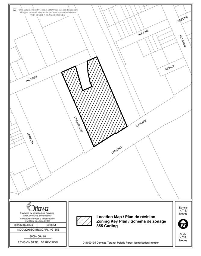
The subject site is located at
the northeast corner of Carling Avenue and Champagne Avenue. The property is
bounded on the south by Carling Avenue which is a designated Arterial
Mainstreet, Champagne Avenue to the west, Hickory Street to the north and the
O-Train corridor to the east. West of the site is an existing office
development consisting of two office towers, nine and seven storeys
respectively.
North of the site is a vacant residential
property that is the subject to an application for change in zoning. East of
the site is the north-south O‑Train line and south of the site on the
opposite side of Carling Avenue are federally owned lands which are currently
vacant. The property is approximately 0.9 hectares in area. The property has
a frontage of approximately 71 metres along Carling Avenue and is approximately
122 metres in depth. This property occupies almost an entire city block
except for a small irregular parcel known as 140 Hickory Avenue. The site is
currently being utilized as a surface parking lot comprised of 300 spaces
servicing Civic Hospital employees.
The property is located within
the Preston-Champagne Secondary Plan and is subject to two land use
designations under the Secondary Plan. The southern portion of the property is
designated as High-Profile, Offices and the northern portion is designated as
Medium-Profile, Offices.
Under the
Primary Official Plan, the property is located at the southern edge of an area
designated as a Mixed-Use Centre on Schedule B, Urban Land Use. The Mixed-Use
Centre designation extends from the subject site to Carling Avenue along the
O-Train Corridor, and is currently subject to the Carling-Bayview Community
Design Plan (CDP) process. As a Mixed-Use Centre, the site is identified as
offering potential for advancing and achieving the City's intensification
objectives through compact mixed-use development focused on the City's transit
system. An analysis of the nature and intensity of development for all lands
within the CDP area is intended to be completed through the CDP process.
The section of Carling Avenue
abutting the subject property is designated as a Supplementary LRT Transit
Intensive Corridor in the City's Transportation Master Plan, to provide a
future at-grade LRT connection to the main Rapid Transit Network at Lincoln
Fields and Carling Stations within the 2031 planning horizon. Carling Avenue is
also subject to the Western LRT Corridor (Bayview to Baseline) Planning and
Environmental Assessment Study (ACS2009-ICS-PLA-0050) which is currently
underway and may accelerate LRT implementation along Carling Avenue as a Rapid
Transit Corridor rather than as a Supplementary LRT Corridor, subject to the
requirements of the Transit Project Assessment Process (Ontario Regulation
231/08) under the Ontario Environmental Assessment Act (OEAA) and the Canadian
Environmental Assessment Act (CEAA). The intersection of Carling Avenue
and the existing north-south O-train line is a significant intersection with
respect to the future development of light rail transit and as a result,
additional land requirements beyond the protected right-of-way outlined within
the Official Plan will require protection.
Purpose of Zoning
Amendment
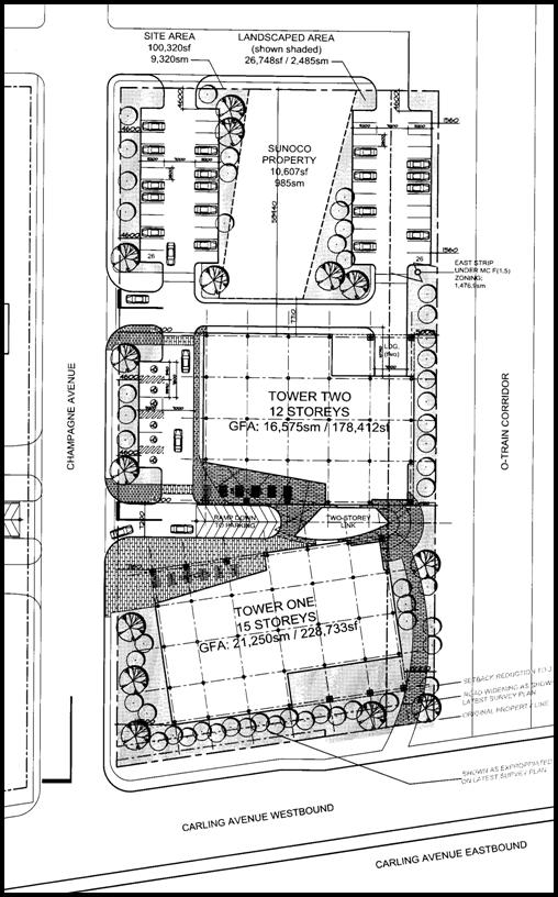
The applicant is proposing to
construct two new office towers, which will be connected via a second-storey
link as shown on Document 3. Tower "One" will be approximately 56
metres (15 storeys) in height and front along Carling Avenue. Tower “One”
would be setback approximately three metres from Carling Avenue and six metres
from the O-Train corridor abutting the eastern portion of the site. Tower
"Two", which will be located approximately in the middle of the
subject property, will have a height of 45 metres (12 storeys) and be setback
19 metres from Carling Avenue and five metres from the O-Train corridor.
Four levels of underground
parking are proposed that will create 742 spaces, to be accessed from
Champagne Avenue. Also, 58 surface parking stalls are proposed to be provided on
the northern and western edge of the property. Vehicular access to the site
would be from Champagne Avenue and Hickory Street. There is no proposed access
to the site from Carling Avenue.
Existing
Zoning
The property currently has two
zoning designations. The western portion, and the majority of the property, is
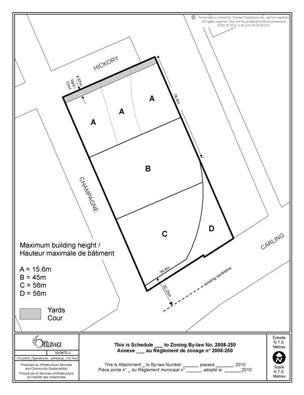
zoned "Mixed-Use Centre" MC[24] F(2.5) S129. Exception 24 refers to
a maximum building height as per Schedule 129, which varies from a permitted
height of 15.6 metres for the northern portion of the site along Hickory
Street (Area "A" of Schedule 129), 27.3 metres mid-block (Area
"B") and 39 metres for the southern portion of the site along Carling
Avenue (Area "C"). Exception 24 also refers to specific yard requirements,
which includes a minimum 9.14-metre set back along Carling Avenue, and a 4.7-metre
setback along Champagne Avenue and Hickory Street. Exception 24 also requires
that 50 per cent of the required parking be located below grade or within a
parking structure. The permitted floor space index (FSI) for this portion of
the property allows for the gross floor area of a building to be 2.5 times
the total lot area.
The eastern strip of the property
is zoned "Mixed-Use Centre" MC F(1.5). The permitted FSI for this
portion of the property allows for the gross floor area of a building to be 1.5
times the total lot area.
Proposed
Zoning
The applicant is requesting an
amendment to Schedule 129 to allow for an increase in the permitted height
within Area "A" from 39 metres to 56 metres, and an increase in the permitted
height within Area "B" from 27.3 metres to 45.0 metres. The current
permitted height of 15.6 metres for Area "C" of Schedule 129
would remain. The applicant is requesting a further amendment to Schedule 129
to allow for a reduced front yard setback along Carling Avenue of 9.14 metres
to 3.0 metres. The remaining provisions of Exception 24 would continue to
apply with respect to parking. The applicant is also requesting an increase in
the floor space index (FSI) on the west side of the site from 2.5 to 4.1, and
an increase in the FSI on the east side of the property from 1.5 to 4.1 to
facilitate the proposed development.
DISCUSSION
Strategic Directions
To meet the challenge of managing
growth the City will direct growth to the Urban Area, and specifically to areas
designated as Central Area, Mixed-Use Centres, Employment Areas, Enterprise
Areas, Developing Communities and Mainstreets. These areas include locations
that are centred on the rapid-transit network, major roads, commercial streets,
and large tracts of vacant land. The City will encourage a pattern and density
of development that supports transit, cycling and walking as viable
alternatives to the automobile.
Development in these areas can
strengthen the urban structure, balance housing and employment uses, and make
transit provision more efficient.
These areas offer substantial
opportunities for new development or redevelopment and represent a key element
in the Official Plan’s strategy to accommodate and direct growth in the city.
Mixed-Use Centres will grow substantially, but in a way that complements the
development pattern within and adjacent to them.
A key direction for areas where
more intense mixed-use development is to be provided, and specifically for
Mixed-Use Centres, is that they be developed as centers of activity in a way
that is compact and will contribute to place-building through an organization
of uses and urban form that provides for a strong pedestrian environment and
orientation to transit along with strong interconnections to and through
adjacent areas.
Mixed-Use Centre and Arterial
Mainstreets
The subject property and adjacent
areas are designated Mixed-Use Centre and this section of Carling Avenue is
designated Arterial Mainstreet on Schedule B of the Official Plan (OP). Mixed-Use
Centres are strategic locations along transit corridors that act as focal
points of activity for both the local and regional community. These areas have
a high potential for mixed-use, compact development and are to develop as
vibrant places in their own right as components of a complete neighbourhood.
Development within a Mixed-Use Centre should take advantage of the
opportunities offered by transit, and for ease of cycling and pedestrian
movements. With a focus placed on urban design and a mix of uses, these areas
will contribute to diversity in the area and facilitate the creation of centres
of activity. The proposed development concept as shown on Document 3 introduces
a density and form of development that is appropriate taking into consideration
the policies of Mixed-Use Centres and Arterial Mainstreets.
Along Arterial Mainstreets
redevelopment and infill is encouraged to optimize the use of land through
increased height (up to eight storeys) and density. Additional increases in
height and density along Arterial Mainstreets are to be considered in
circumstances where the development is at a gateway location or at a location
where there are opportunities to support transit, at a transit stop or
station. The site is located just west of the Preston Street (Little Italy)
gateway at the intersection of Carling Avenue and Preston Street. As well, the
site is at a strategic existing transit location, just west of the existing
north-south O-Train line, and along existing bus routes on Carling Avenue.
Based on the above criteria to be considered in such requests, the proposed
increase in height and increased floor space index (FSI) is consistent with the
direction of the OP for Arterial Mainstreets that allows for such
considerations. The existing maximum permitted height on the southern portion
of the site along Carling Avenue would permit a building approximately 11
storeys in height with a 3.5-metre floor to floor plate, which currently
exceeds the OP policy. The proposed building height of 15 storeys for Tower
One is considered a minor increase from the current permitted height, and any
potential impacts may be further reduced through the Site Plan Control process.
With the placement of the
proposed 15-storey office tower a maximum of three metres from Carling Avenue,
a strong street edge is created with ample room for improved sidewalks to allow
for easy pedestrian movement both within the site and through to access the
O-Train station to the east and bus stops along Carling Avenue. The existing
sidewalk along Champagne Avenue allows for movements to the north into the
existing neighbourhood and is further enhanced with additional landscaping and
courtyard elements at grade within the design of Towers One and Two.
As a result, the reduced front
yard setback along Carling Avenue from 9.14 metres to 3.0 metres is
considered appropriate for the site towards advancing the urban design of this
Arterial Mainstreet.
Regarding the mix of uses which
typically accompany increased density within Mixed-Use Centre developments, the
proposed concept plan does not provide any ground floor retail or commercial
space which can inhibit the implementation of the Mixed-Use Centre policies that
speak to creating lively places with a range of uses that appeal to the local
and wider community. As a result, staff recommends that the implementing By-law
as shown on Document 2 require that retail, commercial or personal service type
uses be located at-grade along the frontage of Carling Avenue. The proposed
performance standard would implement the intent of the Mixed-Use Centre
policies to develop such areas as vibrant spaces which are part of complete
neighbourhoods.
Last, as Mixed-Use Centres are
strategically located with respect to the transportation system and are
accessible by transit, both the existing and planned function of the area must
be protected where possible, while not interfering with as-of-right development
situations. As the subject property is designated as a Supplementary LRT
Transit Intensive Corridor to provide a future at-grade LRT connection to the
main Rapid Transit Network within the 2031 planning horizon, and also subject
to the Western LRT Corridor Planning and Environmental Assessment Study
currently underway, staff have completed an assessment of the site and
determined an appropriate area to be protected from the developable area of the
property as shown on Document 4. Staff recommends that a triangular piece of
land at the southeast corner of the site preclude any form of development or
use other than a public transit use. As well, the recommended by-law would
also restrict development within a vertical area extension of this triangular
area for a height of approximately 15 metres, effectively creating a
three-dimensional box to be used only for transit infrastructure, the details
of which are not known at this time. As a result, the development concept
would need to be revised accordingly to accommodate the excluded area, which
will impact the proposed pedestrian walkway along the eastern portion of the
site. However, staff feel that through the detailed design and Site Plan
Control process an appropriate design can be brought forward that respects the
intent of the Mixed-Use Centre and applicable design guidelines. Due to the
strategic location of the site relative to the various land use designations,
and the unknown aspects regarding the specific transit technology to be
implemented at this site, it is appropriate to secure this portion of the site
for future transportation infrastructure needs.
Compatibility and Community
Design
Direction is provided in Section
2.5.1 as to the meaning of compatible development. In general terms, it
provides for compatible development meaning, development that although not
necessarily the same as or similar to existing buildings, nonetheless enhances
an established community and coexists with it. The development fits well
within its physical context and works well among the functions that surround
it. Broad design objectives are set out as to how the City wants to influence
the built environment. These objectives are generally stated and are
applicable to all land use designations either at the city-wide level or on a
site-specific basis. Design principles are further set out to describe how the
City hopes to achieve the design objectives, with acknowledgment that all the
design objectives may not be achievable in all cases.
The proposed development is
consistent with and implements the various aspects of the design objectives and
principles discussed below. The objectives of greatest significance to the
application speak to enhancing the sense of community, defining quality public
and private spaces through development and providing for the creation of
adaptable and diverse places.
The first design objective
to enhance a sense of community is achieved by infilling a large, underutilized
vacant site that does not continue a built form within a designated Mixed-Use
Centre which is also along a transit priority route. The development will
establish a focus at a key location along Carling Avenue, within the southern
limit of the Preston-Champagne Secondary Plan that can
contribute to the redevelopment of the immediate area as a significant place
under the applicable land use policies.
Encouraging a
continuous street frontage and being cognisant of pedestrian needs that
contribute to public spaces, is the second key design objective. As a result
of the decreased setback along Carling Avenue, a tighter built form is created that
is currently absent due to the use of the site as a surface parking lot. The
integration of walkways, landscaping and open spaces at grade provides some
variation that serves to create an amenity area and space for pedestrian
movement through the site and through the immediate area. With respect to
meeting the needs of pedestrians, the introduction of new commercial or retail
uses at grade, as recommended, will create opportunities for social and
commercial interactions that previously did not exist. The proposed design will
take advantage of the natural focal point along this segment of Carling Avenue
and the significant location along the existing and proposed transit network.
The objective of creating adaptability and diversity
will be implemented through a more diverse building envelope that efficiently
uses land while contributing to the regeneration of Carling Avenue. The
development as proposed will create new employment space with additional retail
and service uses as recommended. The development will also help reduce
resource consumption by intensifying inside the Urban Area along a Transit
Priority Corridor and by providing services to local residents.
Preston-Champagne
Secondary Plan
Schedule L of
the Preston-Champagne Secondary Plan identifies the site as being
located in the southwest quadrant of the Plan area. The property has two
employment designations as per Schedule L with the southern portion of the
property designated as High-Profile, Offices and the northern portion
identified as Medium-Profile, Offices. The Preston-Champagne
Secondary Plan does not contain specific height limitations but rather outlines
various profiles for the land use schedule. The planned function for
this area speaks to a mix of medium-profile and high-profile employment uses
focusing on both sides of Carling Avenue including existing buildings. The
northwest edge of the area will be redeveloped with low-profile residential
uses to provide a transition to the existing lower-profile residential areas to
the north and west. As well, the policies of the Preston-Champagne
Secondary Plan speak specifically to the area around Carling and Champagne
Avenue to become a Secondary Employment Centre, and should consider development
proposals which provide for a mix of uses, with residential uses integrated
within to allow for a decreasing transition in development moving north from
Carling, with landscaped spaces and pedestrian links between spaces and to transit.
For predominately office-oriented developments, surface parking shall be
permitted within the first phase only and limited, with subsequent phases to
provided structured or underground parking. As the concept plan proposes
building heights decreasing from 15 storeys on the southern edge to 12 storeys
mid-block, serviced with four levels of underground parking and limited surface
parking, the proposal is consistent with the intent of the Preston-Champagne
Secondary Plan. Where the project is not consistent with the Secondary Plan relative
to providing a mix of ancillary retail and services uses, and as a result the
recommendation requires appropriate non-residential uses to be located on the
ground floor along the Carling Avenue frontage in order to create a more active
street environment.
RURAL IMPLICATIONS
N/A
CONSULTATION
Notice of
this application was carried out in accordance with the City's Public Notification
and Consultation Policy.
COMMENTS BY THE WARD COUNCILLOR(S)
The Ward
Councillor is aware of this application and the staff recommendation.
LEGAL/RISK MANAGEMENT IMPLICATIONS
The zoning for this site has been
appealed to the Ontario Municipal Board as a decision has not been made within
120 days of the application having been deemed complete. A seven-day hearing
is scheduled commencing 7 September 2010. Should the staff recommendation be
adopted, then the hearing can be conducted within staff resources.
Should the recommendation be
refused, it will be necessary for the City Clerk and Solicitor Department to
seek to retain an outside plan. It is anticipated that the expenditure
required to retain an outside planner for the hearing will be in the order of
$35,000 to $45,000.
In order to achieve Council
objectives, Committee and Council may wish to consider amending the applicable
zoning in any event to provide for the retail, commercial or personal service
type uses at grade and the setback from the rail line.
CITY STRATEGIC PLAN
The application is consistent
with the Planning and Growth Management priority which encourages the
development of employment lands to promote job creation and minimize
infrastructure costs.
TECHNICAL IMPLICATIONS
N/A
FINANCIAL IMPLICATIONS
There are no direct financial
implications associated with this report.
APPLICATION PROCESS TIMELINE STATUS
The
application was not processed by the "On Time Decision Date"
established for the processing of Zoning By-law amendments due to additional
time required for the assessment and analysis of the potential conflicts with
the development of the site and the advancement of future transit services.
SUPPORTING DOCUMENTATION
Document 1 Location
Map
Document 2 Details of
Recommended Zoning
Document 3 Concept
Plan
Document 4 Protected
Transit Corridor
Document 5 Consultation
Details
DISPOSITION
City Clerk and Solicitor
Department, Legislative Services to notify the owner, applicant, OttawaScene.com, 174 Colonnade Road, Unit #33,
Ottawa, ON K2E 7J5, Ghislain Lamarche, Program Manager, Assessment, Financial
Services Branch (Mail Code: 26-76) of City Council’s decision.
Planning and Growth Management to
prepare the implementing by-law, forward to Legal Services and undertake the
statutory notification.
Legal Services to forward the
implementing by-law to City Council.
LOCATION MAP DOCUMENT
1
DETAILS OF RECOMMENDED
ZONING DOCUMENT 2
Proposed Changes to By-law 2008-250
1. Replace Schedule 129 with a new schedule as shown
on Document 3.
2. In Exception 24 of Section 239, Urban Exceptions:
(a) delete the zone code
in column II and replace it with MC[24] F(4.1) Sxxx
(b) delete the provisions
in column V and replace them with the following:
- maximum building height, and required Hickory Street yard
setback in accordance with Schedule 129
- at least 50% of required parking spaces to be located
below grade or in a structure
- only the following uses are permitted on the ground floor
of that portion of a building along Carling Avenue for a depth of 21
metres from Carling Avenue:
artist studio
bank
bank machine
bar
cinema
community centre
community health and resource centre
convenience store
day care
instructional facility
library
medical facility
museum
nightclub
personal service business
Post office
recreational or athletic facility
restaurant
retail food store
service and repair shop
theatre
- lobby area can only occupy a
maximum of 25% of the ground floor of that portion of a building along
Carling Avenue for a depth of 21 metres from Carling Avenue
- minimum yard setback from the
south lot line abutting Carling Avenue: 3.0 m
- minimum yard setback from east
lot line abutting the transit corridor of the O-Train: 4.57 m
- minimum yard setback from west
lot line abutting Champagne Street: 4.57 m
- In Area D on
Schedule 129 the only permitted use in the three dimensional area measured
from grade to a height of 15.0 metres is a rapid transit network
3. Rezone the land from MC[24] F(2.5) and MC
F(1.5) to MC[24] F(4.1) Sxxx as shown on Document 1.
Revised Schedule 129
CONCEPT PLAN
DOCUMENT 3
PROTECTED TRANSIT CORRIDOR
DOCUMENT 4
CONSULTATION DETAILS DOCUMENT
5
NOTIFICATION AND CONSULTATION
PROCESS
Notification and public
consultation was undertaken in accordance with the Public Notification and
Public Consultation Policy approved by City Council for Zoning By-law amendments.
SUMMARY OF PUBLIC INPUT
Five letters were received from
the public and the local community association as a result of the circulation.
A summary of the comments and concerns raised and a response are summarized
below.
1. Concerns were raised with respect to a potential increase
in traffic in the area.
Response:
The applicant
has prepared a traffic impact assessment in support of their application which
has been reviewed and approved by staff. Through the Site Plan Control process
a detailed analysis of the traffic impacts and site design will be undertaken.
2. A request was made that the subject application be
postponed to allow for the completion of the Carling-Bayview Community Design
Plan.
Response:
The policies
within the Official Plan allow for development outside of a completed Community
Design Plan, and such an application will be reviewed against the applicable policies
of the Official Plan. Staff are satisfied that the proposal implements the
intent of the Mixed-Use Centre policies with a pedestrian friendly, transit
supportive and compact development, while having due regard for the policies
with respect to compatibility and urban design.
3. Concerns were raised with respect to the potential increase
in shade and loss of sunlight on abutting residential areas to the north
Response:
Through the
Site Plan Control process the applicant will be required to submit a sun-shadow
analysis of the proposed development to better evaluate and consider such
potential impacts.
COMMUNITY
ORGANIZATION COMMENTS
Dalhousie
Community Association
The Dalhousie Community
Association requests that the City postpone considering the current application
until such time as the Carling-Bayview Community Development Plan is
completed. The Dalhousie Community Association is also concerned with how the
proposed building may restrict a future LRT access Carling Avenue and request
the application not be considered until the appropriate studies are complete.
Simon Deiaco,
Planner, provided an overview of the application and staff’s rationale for
recommending approval. He was accompanied by Alain Miguelez, Program Manager,
Development Review Process (Urban) and Richard Kilstrom, Manager of Policy
Development and Urban Design. A copy of staff’s PowerPoint presentation is
held on file with the City Clerk.
In response
to questions from the Chair, Tim Marc, Senior Legal Counsel, explained that the
matter would be subject to an Ontario Municipal Board (OMB) hearing on 7
September 2010. He explained that it was necessary to bring forward the report
to the Committee at the present time because in order to provide Legal Services
with instructions from Council as to what position to take before the OMB. He
further confirmed that, should Council take a position other than that
recommended by staff, the City would need to retain an outside planner to
defend Committee and Council’s decision before the board.
Councillor
Holmes observed that it seemed to be an emerging pattern for applications to be
appealed to the OMB when the City does not complete its process in 120 days,
thus forcing the matter to Council to obtain direction. Mr. Marc agreed there
had been a few such cases recently, citing 187 Metcalfe Street and 801 Albert
Street as examples. He suggested there was a need to wait and if it was a
trend. He confirmed that the need to retain an outside planner to defend
Council’s decision was a further reason for the matter to be brought forward
sooner, as the earlier the planner is retained, the better it looks to the
board. Councillor Holmes expressed concern that in such cases they were
running out of time for public consultation and impacting the ability for all
affected to become knowledgeable about the application and provide comments if
they so wished.
In response
to questions from Councillor Holmes with respect to how the potential rapid
transit corridor would be protected on the site, staff provided the following
information:
·
In “Area D,” on Schedule 129, the only permitted use in the three
dimensional area measured from grade to a height of 15 metres is a rapid
transit network. While this creates an area where no other use would be
permitted, it would not preclude building over top of that envelope, allowing
the applicant to optimize their land and allowing the City to protect what is
needed to allow the potential LRT connection to be made.
·
The specific technology, track alignment and design for the
western rapid transit corridor is not yet complete, and there would be many
factors considered in the design and location of the station, and whether it
could be on this site.
·
LRT staff is comfortable that Area D is appropriate and
represents a radius of a turn that can be made by a future train.
·
There is the possibility that a building could be constructed
prior to Council obtaining information on the potential design of the rapid
transit connection or station, which will likely be 1-2 years in the future.
Although currently no application had been submitted for site plan control, the
applicants could move forward with a site plan control application and
construction. Through the site plan control process staff would look at
refinements to the original concept.
·
As to whether the City could prevent the loss of the capacity to
build the station into the building, Mr. Marc confirmed the report would not
preclude construction before the City understands the station parameters. He
suggested the only way Council could ensure nothing took place on the site
would be to impose an interim control by-law that would take away immediate
building rights.
·
While the moratorium on development in the Carling-Bayview Community
Design Plan Area would not permit rezoning, it would still allow the applicants
to build within the existing zoning.
Councillor
Leadman suggested that, as the ward Councillor, she was not consulted on the
report. She expressed concern that the report recommendations should have been
brought forward to her prior to them coming to Committee, notwithstanding the
fact that the purpose of the report was to give direction before the OMB. She
suggested that part of the delay in consideration of the report was
attributable to the fact that planning staff had not acknowledged that the
transit corridor would be impacted, and this had to be determined through a
separate study. She questioned the fact that staff were recommending the
approval of 800 parking spaces on the site, even as they were recommending
additional height because it is a transit corridor, but. She suggested this
was contradictory to the intent of the planning and intensification model.
In response
to questions from Councillor Leadman, Mr. Deiaco explained that the staff recommendation
before Committee was to amend Schedule 129 to allow an increase in height, and
to require a performance standard that makes retail uses mandatory at grade
along Carling Avenue to further advance the policies of the Secondary Plan and
mixed-use centre designation. As to whether this would be a commercial or
residential property going forward on the lot, Mr. Marc indicated that he had
not been able to clearly identify whether or not it would be commercial or
residential. He expressed his understanding that the report was prepared on
the basis that the site would be an office development; however, the applicant
had not confirmed that was their intention.
Councillor
Leadman introduced the following motion, to be moved on her behalf by
Councillor Holmes:
WHEREAS
the zoning of 855 Carling is before Committee and Council;
AND
WHEREAS this provides an opportunity to promote transit in the vicinity of the
Carling O-Train station, to protect for a future transit station and to
provide for the enhancement of the variety of uses within a Mixed Use
designation fronting on an Arterial Mainstreet;
AND
WHEREAS this rezoning has been considered by the Public, Committee, Council and
Staff on the basis that the rezoning was sought for non-residential purposes
and that if a residential rezoning is sought, the matter should be brought back
for further consultation and consideration, and therefore Item c) below has
been included to express this determination on the part of Council;
THEREFORE
BE IT RESOLVED THAT with respect to 855 Carling:
Planning
and Environment Committee recommend to Council that:
A zoning
by-law amendment be enacted to provide:
a)
that for Area D on Schedule 129 the only permitted use in the
three dimensional area measured from grade to a height of 15.0 metres is a
rapid transit network;
b)
The uses along the ground floor are limited in accordance with
the third bullet point under item 2) in the Details of the Recommended Zoning;
and
c)
With respect to the land located within each applicable zone as
of this date, a building containing residential uses shall not be permitted to
exceed either the height or the f.s.i. in place on 25 May 2010; and
d)
The number of automobile parking places be limited to an amount equivalent
to the minimum parking requirement for Area A plus an additional 25 places to
provide for flexibility.
And that
no further changes be made to the applicable zoning at this time
And that
no further notice be given, pursuant to the Planning Act, subsection 34(17)
She suggested
the motion would provide legal staff with the tools they needed before the
OMB. She suggested that the delay beyond 120 days was unfortunate, but
unavoidable due to the lack of attention to the transit corridor. She suggested
that, given the investment the City was making in transit, this site was
critical. She encouraged Committee to support the motion.
Committee
then heard from the following Public Delegations:
Michael
Polowin, Gowlings, Lafleur, Henderson and Murray Chown, Novatech
Consulting, spoke on behalf of Dow’s Lake Court Inc, owners of 865 and 875
Carling Avenue and 140 Hickory Street. Mr. Polowin indicated that his comments
applied to the proposal for a commercial office development, and might be
different should the application prove to be something else. He noted that the
massing of the proposed development impacted his client’s land, and expressed
concern that the staff report had insufficient regard to Official Plan (OP)
policies, particularly with respect to transit and arterial mainstreets. He
noted the arterial mainstreet policies concerning suggest a height of eight
stories, and the as of right zoning is 11 stories. He also noted that the
arterial mainstreet zoning suggests the lower height should be adjacent to the
arterial mainstreet, rising to the back, while the subject proposal does the
opposite. He expressed further concern with access to the Transitway for
properties located to the west, suggesting the development would restrict
access for his client’s property. Written submissions from Mr. Polowin were
circulated to Committee members and are held on file with the City Clerk
Mr. Chown
referenced a Planning Review report Novatech had prepared for Dow’s Lake Court
inc., which was provided to Committee members and is held on file with the City
Clerk. While he indicated that he had no challenge to the general objective of
the applicants to increase the amount of buildable space on the property, he
asked Committee to consider the following:
·
Through negotiations on this application, there should be the
opportunity for the City and the proponents to discuss the ability to integrate
the development with the Transitway, in particular a Carling Avenue transit
station. He suggested the opportunity to do so would be lost if not done now.
·
While there was the ability, as of right, to locate a structure
on Carling Avenue at 10-11 stories in height, he suggested that did not make it
the right thing to do. He noted the policies and design guidelines for arterial
mainstreets emphasize the objective of a human scale of development along those
streets. He suggested there may be the ability to negotiate a compromise to
achieve those objectives by reducing the scale of development along Carling
Avenue, while compensating for that by increasing heights on the north part of
the site in order to accommodate same amount of built space.
·
The requirement for some pedestrian and public uses on ground
level could provide integration to Carling Avenue, and could provide an active
and viable link for pedestrians to the transit station.
In
conclusion, Mr. Chown suggested there was tremendous possibilities on the site
and hoped Council make the right decision and address the issues raised in his
presentation.
Janet Bradley
spoke on behalf of Soho Champagne Condominiums Inc., owners of the property at
125 Hickory Street. She indicated her client supported the proposal, as
outlined in the report, for two commercial office towers and. She suggested
the proposal was a good fit, in line with the Preston-Champagne secondary plan
and the parent OP. However, she expressed concern with the possibility that
the development would be changed to a residential development. She indicated
that her client has concern that the applicants planned a “bait and switch,”
telling everyone the development would be an office building in compliance with
the secondary plan, securing the zoning to increase the amount of built form,
then switching it to residential, noting that the mixed-use designation allowed
either.
Ms. Bradley
proposed that office buildings were more in compliance with the secondary plan,
as such Council should consider a zoning bylaw that tailors the uses permitted
on the site to that which comply with the secondary plan. In summary, she
reiterated that her client supported for a by-law that is tailored to permit
the development outlined in the report; however, if the by-law continued to
permit residential or development further to the north on the site, her client
had concerns with the appropriateness of the development.
Councillor
Hunter suggested that the time to have raised concern with the possible
residential use would have been at the time of the Comprehensive Zoning Bylaw
when the MC mixed use zone was being considered for the site. Ms. Bradley
noted that her client had purchased the land in January 2010, knowing there was
an MC zoning on the adjacent property, but knowing that zoning was for a
certain height and amount of space. The concern is that the applicant was
seeking a significant increase in height and amount of space. While she
generally had no objection to more residential development in the area, she
expressed concern that, while the two proposed commercial towers would front
off Carling Avenue, the rumoured residential proposal would have two
residential buildings to the rear of the site, immediately adjacent to the
low-scale development on her client’s site. She suggested the issue was one of
compatibility of the adjacent use and how the whole area was originally planned
In response
to questions from Councillor Leadman as to whether the proposed motion from
Councillor Holmes would address her client’s issues, Ms. Bradley maintained
that the only way to address the issue was to change the Zoning By-law. She
emphasized that if Council was going to grant more rights, more density, and
more height for the site, it should grant those rights in the direction of your
official plan, which is office development.
In response
to questions from Councillor Feltmate with regards to the Preston-Champagne
secondary plan and its relationship to the Carling-Bayview CDP currently
underway, staff explained that the two plan areas overlap, but the CDP area is
significantly larger than the secondary plan area. While the secondary plan is
an adopted document, the CDP is in process and there could be some further
overlap with their respective policies.
Councillor
Doucet suggested the subject site at the junction four wards: River Ward,
Somerset Ward, Capital Ward and Kitchissippi Ward. He questioned why staff had
not taken time to consult with the councillors of the abutting wards before the
matter came to Committee. In response to the Councillor’s concerns that the
process was being driven by the developers and the OMB rather than the citizens
and elected representatives, noted that, while there were certainly concerns
with that process, the City had to comply with the rules laid out by the
Province. He reiterated that legal staff required Council to make a decision
to provide direction before the OMB, and if that recommendation was not in line
with staff’s, additional time was required to retain an outside planner. He
maintained that the application could be delayed no further if they were to
present an appropriate case before the board.
Councillor
Doucet expressed concern that allowing development on the site would eliminate
possibilities for connecting a carling avenue rapid transit corridor with the
north-south line, which has enormous consequences for the city.
Mr. Miguelez
explained the challenge posed by the fact that, while the results of the
Environmental Assessment (EA) for the western transit corridor was one to two
years away, the City was faced with an application under the Planning Act
and an appeal to the OMB due to non response. He indicated that staff had
initiated an accelerated process in order to determine what the City needed to
do to ensure the possible transit corridor was removed a result of a
development on the. He explained that, in the absence of a competed EA, Dillon
Consultants had been retained to do an analysis to establish the requirements
of this particular location and how to safeguard the transit corridor. He
outlined the details of how the potential transit corridor would be preserved
in Area D of Schedule 129, which provides the required arc for the vehicles to
turn.
Councillor
Doucet indicated that, while he was glad to see an effort to protect the
corridor, he lacked confident that it would be adequate, indicated he had
remaining reservations about the ability for a train or bus to make the turn in
the space identified under Area D. At the suggestion of the Chair, staff
agreed to share the results of the Dillon report with Councillor Doucet, so
that he could be confident in its recommendations.
Shirley
Rayes, Civic Hospital Neighbourhood Association, spoke in opposition to the
proposal. She expressed several concerns, as summarized below:
·
The residents and community association received very short
notice of the application, with little time to read and prepare for the
meeting
·
The community association’s comments are not contained in the
report, and they certainly have comments.
·
The community association vehemently opposes the zoning, as it is
incompatible with the current neighbourhood.
·
The report shows a flawed traffic analysis. The traffic analysis
indicates that there would be serious intrusions into the neighbourhood, as
traffic would be directed via a residential street to the failed Queensway ramp
at Parkdale. She suggested that the better access to the Queensway would be
via Carling Avenue, noting City traffic experts she had spoken to confirmed
this.
·
She suggested the community was already being assaulted by a
number of development projects, and maintained any request in excess of the
current zoning was counterproductive, given the future transit plans, and an
affront on the area’s residents.
Ms. Rayes
also submitted detailed written comments, which were circulated to Committee
members and are held on file with the City Clerk.
Alayne
McGregor spoke in opposition to the proposed development. She also
submitted detailed written comments, which were circulated to Committee members
and are held on file with the City Clerk. The points raised in her presentation
are summarized below
·
The proposed development would put significantly more vehicle
traffic in a neighbourhood that is already having problems with congestions on
many of the streets that are used for neighbourhood traffic.
·
The addition of more traffic to the area would make it
increasingly difficult for cyclists.
·
While the increased height and density of the project is
predicated on its immediate proximity to the O-Train, it is still allowing for
800 parking spaces, which she suggested did not make sense.
·
She proposed that, if Council supported the project, should
substantially reduce the parking.
·
She noted that the Telus building downtown has 80 per cent of its
employees coming in by transit, cycling or walking. She suggested that, given
the excellent transit accessibility of the subject site, the amount of car
parking could be reasonably reduced to 160 spaces.
·
She suggested the neighbourhood could not support the additional
car traffic, particularly in the context of all the new developments which are
happening in the same general area.
Councillor
Hunter challenged the delegation’s recommendation for reduced parking in
development, suggesting this would result in workers seeking street parking in
the surrounding neighbourhood. He suggested this would be to the detriment of
surrounding residents and businesses. Ms. McGregor countered that if there is
less parking, many people will look to alternatives such as transit, cycling
and walking, and emphasized that there needed to be promotion of those alternatives.
In response
to questions from Councillor Leadman, staff confirmed that the modal split
being used for the subject property was 30 per cent for the year 2011, rising
to 35 per cent in 2016. Councillor Leadman suggested that, given the transit
usage being used to justify the height increase, the amount of parking provided
was questionable.
In response
to questions from Councillor Qadri with respect to the ancillary parking for
the Civic Hospital that was currently located on the site, Mr. Deiaco expressed
his understanding that the proposed parking structure would not house those 300
parking spaces, so the hospital would need to make alternative arrangements.
In response
to questions from Councillor Holmes with respect to her motion as it pertained
to parking, Mr. Miguelez expressed his understanding that the motion limited to
an amount equivalent to the minimum parking for area A. As the Zoning By-law
designates lower parking requirements for the more central area A, the motion
would have the effect of applying that lower parking limit to the whole
property. Mr. Marc clarified that the motion would limit the parking on the
site to 532 parking places.
Mr. Marc
further explained that the clause of the motion pertaining to residential
development, while somewhat redundant, would to provide the clear intent that
if the applicant wished to go ahead with the residential proposal, the matter
would have to come back before committee and council for further consultation
and decision by council.
Alan Cohen,
Soloway Wright, spoke on behalf of the applicant. He was accompanied by Ron
Jack, Delcan, Ted Fobert, FoTenn Consultants, and Mike Casey,
Campbell Steel and Iron Works Ltd, owner.
Mr Cohen
began by thinking staff for taking the time to meet with the applicants through
the process, and indicating that they were partly in support, and partly
opposed to the staff recommendations. The points raised in his presentation
are summarized below:
·
With respect to the comments made by the previous delegations,
Ms. Bradley and Mr. Polowin, he noted they had not mentioned the adverse impact
on their clients, and suggested that the legitimacy of their positions would be
tested before the OMB.
·
He challenged the suggestion that staff was not aware of the
potential for potential land requirement for transit or the potential
requirement, indicating that it had been known to the applicants for some time
and staff had advised the application would not be processed any further until
such time as a discovery was made about the requirement. It was for this
reason the applicants appealed the matter to the OMB, as it could have been a
considerable before the matter arose.
·
With respect to the limitations on Area D, the potential transit
corridor, he proposed that if the City wanted the property for transit
purposes, they should buy it.
·
With respect to the potential for residential use, he clarified
that the 2008 zoning, and the preceding zoning, permits both commercial and
residential, and suggested this was in conformity with the OP. He indicated
that he had advised both the OMB and staff the lands could be zoned for office,
residential or both and that the residential development might see different
performance standards. He emphasized that the applicants would advise staff, the
OMB, and every person within 400 feet know if this were to be the case.
·
He explained that the Zoning sought applies to residential and
office uses, and the applicants showed an office concept because the office use
creates the greatest demand for parking. He suggested that a residential use
would be a lesser impact on parking and traffic.
·
In summary, Mr Cohen explained that the applicants support the
density and height being proposed by staff; oppose the restrictions on Area D.
·
With respect to the proposed commercial uses at grade, he
questioned the fact that the City was taking Area D for transit use and
imposing the commercial. He also doubted the ability to find tenants for the
commercial space.
Mr. Jack
echoed the comments made by Mr. Cohen, and outlined the results of the Delcan
report submitted with the application in May 2009. The points raised in his presentation
are summarized as follows:
·
The report analyzed this particular concept plan because it was a
potential use of the land and because it generated the most impact in terms of
servicing, traffic and parking.
·
The report stated that the concept plan illustrating an office
development represented only one option for the use of the property, and that a
residential or a mixed-use concept may be pursued by the owner. Each of these
options at the intensification proposed are supported by the applicable policy
and regulatory framework, and all options are actable with respect to existing
roadway and hard service capacity.
·
The traffic analysis based on the office concept represents the
worst case scenario as it relates to traffic generation and municipal services
are available and appropriate for all other options.
·
The site is currently zoned mixed-use center, which permits a
broad range of uses and that reflects the designation of the land, with an
arterial main street designation along the frontage of Carling Avenue.
·
Mixed-use centers are defined in the official plan as strategic
locations with high potential to achieve compact and mixed-use development, are
limited in number and represent opportunities for substantial growth.
·
The policies encourage transit supportive uses including offices
and residential
·
The arterial main street designation on Carling Avenue speaks to
encouraging redevelopment and infill on those locations.
·
While the OP supports eight storeys on arterial main streets, it
provides for consideration of greater building heights where the development
fosters the creation of a community focus, where it is at a corner lot or a gateway
location or at a location where there are opportunities to support transit at a
transit stop or station greater heights will be considered. He suggested the
subject site fit those criteria
·
The Preston Champaign secondary speaks to this area of Carling as
an important entryway into the Preston community.
·
With respect to the requirement for retail at grade along
Carling, he expressed the opinion that there was no basis in the policy and
regulatory framework for either the mixed-use centre or arterial main streets
designation or zoning to specifically require ground floor retail in those
buildings.
·
He suggested the proposal fit with the mix of uses intended for a
mixed use centre, in the context of other uses in the area. He emphasized that
the zoning bylaw states the purpose of both the mixed use center zone and the
arterial main street zone specifically is a broad range of uses (office,
retail, residential etc) and they can occur as mixed-use buildings separate
buildings.
·
On the issue of parking, he noted the parking in the area was
governed by the Zoning bylaw requirement for uses near a transit station, which
sets minimum and maximum requirements. The 800 spaces is within that range,
and in full compliance with the OP.
Ted Fobert
spoke to the status of the rapid transit study that affects this area, in the
context of the development. The following is a summary of the points raised in
his presentation:
·
While the West LRT corridor EA underway would likely identify the
preferred corridor in year, the overall EA would not be finished for two
years.
·
The corridors to be considered in the current study include the
Ottawa River Parkway, the Byron Corridor, Carling Avenue, or some combination
thereof, and those corridors and alignment have not yet determined.
·
While the City is protecting Area D of the subject site, it is
not yet clear whether that parcel would be needed, even if the future O-train
corridor is on Carling Avenue
·
He proposed that area D was not the only way to connect the
north-south line and the Carling corridor, and suggested one alternative could
be to use the parcel to the south, currently owned by the federal government.
·
With regards to access to the transit stations, he suggested that
the proposed development would not prevent access to the existing or any future
transit station on Carling, given how people currently access the O-Train and
the location of the O-Train trench.
·
With regard to station locations, he suggested that if the
transit route ended up crossing Area D of the subject site, there would not be
a station there because the station could not be on a curve.
Mr. Casey
also spoke in support of the proposal. He began by noting that he had advised
Councillor Leadman in 2008 that they would be coming forward with a rezoning for
the property, and had subsequently attended a public meeting in the community.
He raised the following additional points:
·
After months of working with staff, staff advised that the only
way to advance the process was to make an application. He indicated that he
would have preferred to have come to an agreement at the staff level with
respect to the transit turn.
·
He noted that there are other parcels of land at the same
intersection that could accommodate a potential transit connection, and
emphasized that Area D of the subject property was not the only option. He also
confirmed that comments by Mr. Jack that a transit station would make sense on
the site.
·
He noted that his company owns numerous commercial buildings,
some residential, and noted that his brother was the owner of Charlesfort, and
had been consulted on the project.
·
He suggested that, if they wanted to go with a residential
proposal, they would be satisfied with the heights proposed in the report and,
while they might come back for a minor variance, there would be no request for
additional rezoning.
·
With respect to the parking, he suggested the proposed 880
parking was right in the middle of the range required by the by-law.
·
The intent of the rezoning was to protect both the residential and
commercial rights, and a commercial proposal was put forward as that had the
greatest impact.
·
He indicated that, while they had the right to construct both
commercial and residential, they were not certain which would be developed. He
suggested this decision would be based on what opportunities and tenants were
available.
·
He suggested the purpose of the rezoning was to provide the
appropriate parcel, so that he could respond in a timely manner to
opportunities that may arise. He noted that he could not, for example, wait
until a tender from the federal government for office space before applying for
planning variances, given the length of the application process
·
With respect to the discussion about putting retail on the ground
floor, he suggested there was no justification for retail on this complex. He
noted that there was little retail along that part of Carling Avenue, and noted
previous retail initiatives in his neighbouring buildings had been repeatedly
unsuccessful. He proposed that retail would evolve as ne need arose in the
developing area, but suggested it was more likely to happen on the other side
of Carling.
·
With respect to the height and density, de noted that the City
had approved re-zonings for additional height and density for several nearby
parcels. He suggested it would be unfair to deny him those same permissions.
·
With respect to the neighbours, he noted that they had consulted
with them, and made every effort to work with them, but acknowledged not all
issues had been resolved.
·
He expressed that he did not want to delay the decision on what
could be done with the property for an additional two years while the City
decides what to do with the transit corridor and the CDP. He noted the CDP had
already been abandoned once, along with the previous LRT plan, and feared this
could happen again.
Mr. Cohen
provided additional comments with respect to the motion introduced by
Councillor Holmes on behalf of Councillor Leadman. Firstly, he challenged the
statement made in the preamble of the motion that rezoning was being considered
by the Public, Committee, Council and Staff on the basis that the rezoning was
sought for non-residential purposes. He maintained that the rezoning was
sought to permit residential and/or office. With respect to the resolutions,
he suggested that the first two clauses were already contained in the staff
report, and that he did not support the third clause pertaining to the
restriction to residential. With respect to the parking requirement, he maintained
the position that what the applicant proposed was within the appropriate
range.
In response
to questions from Councillor Leadman, the delegations provided the following
additional comments:
·
Regarding the aforementioned public meeting, Mr. Casey confirmed
that the meeting had taken place in 2009, and acknowledged that the Councillor
had raised the issue of the LRT EA, and had indicated that she was not certain
of whether there would be an impact.
·
Mr. Fobert indicated that the Preston Champaign Secondary Plan identifies
Carling Avenue between Champagne Street and Rochester Street as an important
entry way to the community, encourages enhanced treatment to provide an
attractive entrance to the Champagne/Preston area, specifically through the
provision of generous landscaping, the development of prestigious buildings,
locating parking primarily underground and design that provides good pedestrian
connections to the site. He suggested all these objectives were achieved in
the proposal, and reiterated his view that retail is not the most appropriate
activity.
·
To the issue of pedestrian links, Mr. Fobert suggested the
development would be designed to connect appropriately to future transit. He
emphasized that the proposal was at the concept stage and much design work
would be undertaken before completion.
·
Mr. Casey: noted that at the public meeting, some residents
wanted the proponent to build a link over the O-train trench. He noted they
had investigated this possibility, and the cost of doing it exceeded the benefit.
He noted there had also been a suggestions that, as a condition of approval,
the developer build a new Queensway interchange at Rochester, and a large
retail grocery store, and he had indicated to residents these would not be
pursued.
·
On the issue of the transit corridor, Mr. Jack indicated that
they had reviewed the Dillon consultants’ report and Area protects one of a
number of potential transit links. There would still be additional options for
the corridor if Area D is not protected.
In response
to questions from Councillor Qadri, Mr. Casey reviewed the details of the
current arrangement with the Civic Hospital for parking on the site. He noted
that until the site is developed, the lease would likely be renewed on a
short-term basis, but maintained it was not his responsibility to provide
parking to the hospital. He noted that the owners of adjacent building rent
out 300 spaces, as they have parking in that is surplus to their needs.
Lori
Mellor, Preston Street BIA also registered her intent to speak to the item,
but was unable to attend.
Having
completed public delegations, Committee proceeded to questions and debate on
the report recommendations and the motion put forward by Councillor Holmes on
behalf of Councillor Leadman.
In response to
questions from Councillor Leadman, staff provided the following additional
information:
·
The Carling Bayview CDP currently underway encompasses the
subject property.
·
The purpose of a CDP is to implement OP policies by working out
in further detail the land use, design and other considerations and how they
might play out in specific areas.
·
In this particular CDP, one of the main things staff is looking
at is intensification. It will also examine urban design in light of the
City’s new ability under Bill 51 to strengthen their response to urban design,
and may look at the types of uses that would be along the corridor in order to
support the new urban structure that the City is trying to achieve.
·
Infrastructure is a major consideration of this particular CDP,
including piped infrastructure. It is one of the first to include a Master
Servicing Study.
·
Another rationale for looking at this particular corridor is its
placement beside the rapid transit corridor, which is where the OP strategy
targets much of the intensification.
·
With respect to the types of uses required along the corridor to
support intensification, staff views the uses that would be required as ones
that populate the sidewalks with the type of interaction that one would see in
a bustling type of urban area. This would include retail at grade.
·
The Dillon consultant study was completed in late 2009 and
subsequently peer-reviewed by Delcan in early 2010.
·
With respect to the staff report, it was confirmed that once
staff prepare their reports internally, and the report was subject to the
normal planning circulation process that is standard for this type of report.
Councillor
Leadman reiterated her concerns that she had not seen the report until very
late in the process. She confirmed that, while she was not saying staff’s
professional advice would have been different if they consulted with her, she
did feel it put her in an uncomfortable position as the ward councillor to have
not known the recommendations were coming forward, and led to confusion among
the community. She suggested the recommendations may or may not have been
different had consultation taken place. She suggested the motion being put
forward by Councillor Holmes on her behalf addressed some of the serious issues
with the staff report.
Councillor
Leadman noted that the motion before Committee had been reviewed by legal
staff, and was intended to provide direction to legal before the OMB. She
suggested consultation was always important, particularly in an area in
particular that is going through a CDP. She acknowledged the concerns of the
development community when a CDP comes forward, but suggested the City was
faced with many challenges with respect to intensification, transit and
infrastructure. She suggested it was unfortunate to be doing this through a
one-off process, given the cumulative impact of individual applications.
In response
to question from Councillor Leadman, Mr. Marc confirmed that, should Council
approve something other than the staff recommendation, there would be the
requirement to hire an outside planner; however, there would not necessarily be
the need to retain outside legal counsel. The City Clerk and Solicitor would
make the determination on whether the file would be handled in-house or by
external counsel, based on a number of factors such as workload.
With respect
to Area D, Mr. Marc explained that while the report recommendation and the
motion provide for the preservation of “Area D” as something that could be
potentially used by a rapid transit system, they do not mandate that the City
acquire Area D. He suggested if it were later determined that Area D was
required, the City would need to enter into negotiations to purchase the land,
and if those negotiations were unsuccessful, explore expropriation.
In response
to questions from Councillor Hunter, Mr. Deiaco explained that the application
would have been deemed complete shortly after3 June, 2009 commencing the 120
day timeline under the Planning Act. He indicated that signs went up on
the property on 30 June, 2009, and notice would have gone to the Ward
councillor, community associations in Ward 15, and whoever requested notice.
He indicated that, based on the notes left by the previous planner, he did not
believe the councillors in the abutting wards were notified.
Councillor
Hunter suggested that the ward councillor should have organized a consultation
with the Community, as had occurred with a property owned by the same company
in his ward. Mr. Deiaco confirmed that there was a pre-application community
consultation meeting.
As to why it
did the matter did not come to Committee and Council sooner, Councillor Hume
suggested this was because the City needed to determine what right of way
needed to be protected for LRT. Councillor Hunter suggested there had been
plenty of time for the item to have appeared on the Committee agenda. He
further noted that the OP contains provisions directing what should be done
when an application to amend the zoning by-law is submitted and a community design
plan has not been approved, and suggested these requirements had been met for
the subject application. He suggested committee should be considering the
application on its merits and suggested Committee vote in conformity with the
staff report.
Councillor
Holmes agreed that the subject property was an appropriate site for
intensification, and referenced the previous and ongoing CDP processes for the
area. With respect to the motion, she requested its recommendations be split
for voting purposes. She noted that the motion addressed the importance of
protecting Area D for the potential rail plan, an suggested to preclude the
ability for rail to make the turn would be unconscionable, and to have an
underground parking garage at that curve would impede the ability to do so
underground, which may be necessary. She expressed her support for the
requirement for ground-floor retail capacity, and questioned the applicant’s
assertion that it would be difficult to find tenants. She suggested it would
contribute to the kind of activity that would attract people to Preston Street
and surrounding area. Further, she hoped the development would include
pedestrian access through the site to the transit station, and hoped where
would be many more people coming by transit bicycle, walking, as hoped for in
the OP.
In response
to questions from the chair regarding the likelihood for success before the
OMB, should the motion be approved, Mr. Marc provided the following
assessment. He suggested that the first four clauses (A-D) of the motion stood
a reasonable chance of success before the board. However, the subsequent
resolution that no further changes be made to the applicable zoning at this
time, could be a greater challenge given the site’s location.
In response to
concerns raised by Councillor Hunter that the first clause of the motion did
not serve to protect the transit corridor below grade, Councillor Holmes agreed
to amend the motion to provide that Area D would be protected for transit from
below grade up to 15 metres above grade.
Councillor
Hunter suggested that for Council to allow the developer one height for an
office, but not allow that height for the residential as recommended in the
motion was contrary to the policies that the majority of councillors had
approved in the OP. He suggested staff had done a good job ensuring the
application was tested in all aspects of the OP regarding mixed use centres and
intensification. While he recognized the concerns of the councillor and some
residents, he felt that from a City-wide perspective, the better use of the
site was the one that put forward by in the staff report. He indicated his
opposition to Councillor Holmes’ motion and his support for the staff the
recommendations.
Councillor
Doucet reiterated that the subject site was located at the junction of four
wards, and expressed his dismay that the abutting councillors were not
notified. He suggested the subject site was the only point of connection for a
potential Carling transit line to the north-south line is this point, and as
such was a very important piece of property for the City. He suggested all the
City’s official planning calls for that to be the location, and expressed
concern that the City was not taking all possible precautions to protect it.
He referenced his experiences on a recent visit to Chicago, noting how much
public land had been protected in that city, its transit and pedestrian
connections and effective planning. He suggested that, while Ottawa may not be
a world-class city like Chicago, it should aim to be best in its class, and to
give away such a vital piece of land as the subject site was not the way to
achieve it.
Councillor
Leadman spoke in support of the motion. She reiterated her support for the
recommendations of the motion to protect the transit, require main street
ground floor retail, require the applicants return to Council to approve any
residential use, and reflect in the parking requirement the high transit modal
splits are used to support the requested density. She suggested the motion
would provide an appropriate decision for legal staff to bring forward to the
OMB, and supported intensification in keeping with the OP and the smart growth
principles of intensification.
Moved by
Councillor D. Holmes:
WHEREAS
the zoning of 855 Carling is before Committee and Council;
AND
WHEREAS this provides an opportunity to promote transit in the vicinity of the
Carling O-Train station, to protect for a future transit station and to
provide for the enhancement of the variety of uses within a Mixed Use
designation fronting on an Arterial Mainstreet;
AND
WHEREAS this rezoning has been considered by the Public, Committee, Council and
Staff on the basis that the rezoning was sought for non-residential purposes
and that if a residential rezoning is sought, the matter should be brought back
for further consultation and consideration, and therefore Item c) below has
been included to express this determination on the part of Council;
THEREFORE
BE IT RESOLVED THAT with respect to 855 Carling:
Planning
and Environment Committee recommend to Council that:
A zoning
by-law amendment be enacted to provide:
e)
that for Area D on Schedule 129 the only permitted use in the
three dimensional area measured from below grade to a height of 15.0 metres
above grade is a rapid transit network;
CARRIED
f)
The uses along the ground floor are limited in accordance with
the third bullet point under item 2) in the Details of the Recommended Zoning;
and
CARRIED
g)
With respect to the land located within each applicable zone as
of this date, a building containing residential uses shall not be permitted to
exceed either the height or the f.s.i. in place on 25 May 2010; and
LOST
YEAS (2): Councillors
C. Doucet, D. Holmes
NAYS (5): Councillors
M. Bellemare, P. Feltmate, G. Hunter, S. Qadri, P. Hume
h)
The number of automobile parking places be limited to an amount
equivalent to the minimum parking requirement for Area A plus an additional 25
places to provide for flexibility.
LOST
YEAS (2): Councillors C. Doucet, D. Holmes
NAYS (5): Councillors M. Bellemare, P. Feltmate, G.
Hunter, S. Qadri, P. Hume
And that
no further changes be made to the applicable zoning at this time
LOST
YEAS (1): Councillors C. Doucet
NAYS (6): Councillors M. Bellemare, P. Feltmate, G. Hunter, D.
Holmes; S. Qadri, P. Hume
And that
no further notice be given, pursuant to the Planning Act, subsection
34(17)
CARRIED
Mr. Marc
pointed out one additional correction to be made to the staff recommendation,
to change the reference to “Schedule 249” to “Schedule 129.” Committee then approved the report
recommendation, as amended.
That the Planning and
Environment Committee recommend Council approve an amendment to the Zoning
By-law 2008-250 to change the zoning of 855 Carling Avenue from MC[24] F(2.5)
Schedule 129 and MC F(1.5) to MC[24] F(4.1) Schedule 129, as shown on
Document 1 and as detailed in Document 2, as amended by the following
b. that
for Area D on Schedule 129, the only permitted use in the three dimensional
area measured from below grade to a height of 15.0 metres above grade is a
rapid transit network;
And that
no further notice be given, pursuant to the Planning Act, subsection
34(17)
Carried as amended
Councillor C. Doucet Dissented