|
6. COMPREHENSIVE ZONING BY-LAW
2008-250: ANOMALIES AND MINOR CORRECTIONS - SECOND QUARTER 2010 - URBAN AREA RÈGLEMENT DE ZONAGE GÉNÉRAL 2008-250 : ANOMALIES ET
CORRECTIONS MINEURES – DEUXIÈME TRIMESTRE 2010 – SECTEUR |
COMMITTEE
RECOMMENDATION
That Council approve the amendments recommended in Column 3 of Document
1, to correct anomalies in Zoning By-law 2008-250.
RECOMMENDATION DU COMITÉ
Que le Conseil approuve les modifications recommandées
dans la colonne 3 du document 1 afin de corriger des anomalies dans le
Règlement de zonage no
2008-250.
DOCUMENTATION
1.
Deputy City Manager’s report, Infrastructure Services and Community
Sustainability, dated 3 June 2010 (ACS2010-ICS-PGM-0098).
Report to/Rapport au :
Planning and Environment Committee
Comité de l'urbanisme et de l'environnement
and Council / et au Conseil
Submitted by/Soumis par : Nancy Schepers, Deputy City
Manager, Directrice municipale adjointe, Infrastructure Services and Community
Sustainability, Services d’infrastructure et Viabilité des collectivités
Contact Person/Personne-ressource : Richard Kilstrom, Manager/Gestionnaire, Policy Development and Urban Design/Élaboration de la politique et conception urbaine, Planning and Growth Management/Urbanisme et Gestion de la croissance Élaboration de la politique et conception urbaine
(613)
580-2424 x22653, Richard.Kilstrom@ottawa.ca
REPORT RECOMMENDATION
That Planning and Environment Committee
recommend that Council approve the amendments recommended in Column 3 of
Document 1, to correct anomalies in Zoning By-law 2008-250.
RECOMMANDATION DU RAPPORT
Que le Comité de l’urbanisme et de l’environnement recommande au Conseil
d’approuver les modifications recommandées dans la colonne 3 du document 1 afin
de corriger des anomalies dans le Règlement de zonage no 2008-250.
BACKGROUND
On June 25, 2008 City Council adopted the new Comprehensive Zoning By-law 2008-250 that affects all properties within Ottawa. By-law 2008-250 replaces the 36 Zoning By-laws of the former municipalities that were amalgamated in 2001. Since the adoption of the Zoning By-law, staff has been identifying anomalies that require correction, and reports to correct the anomalies are being forwarded to Committee and Council on a regular basis. This report details recommended amendments to correct a number of the identified anomalies in the urban area of the city.
DISCUSSION
Since the adoption of the Zoning By-law 2008-250, staff has monitored the new by-law and has identified certain anomalies that are being recommended for correction. Document 1 provides staff recommendations to Planning and Environment Committee on the anomalies in the urban area.
The amendments are intended to correct mapping and text reference errors in the implementation of Council-approved changes that were not accurately reflected in the Comprehensive Zoning By-law.
RURAL IMPLICATIONS
N/A
CONSULTATION
Notice of the public meeting to deal with these anomalies and corrections was provided in The Citizen and Le Droit, with a listing of the addresses and provisions subject to correction. As well, interested parties have been notified by individual mail.
COMMENTS BY THE WARD
COUNCILLOR(S)
N/A
LEGAL/RISK MANAGEMENT IMPLICATIONS
These changes are of a routine nature to correct anomalies and do not have any legal/risk management implications.
CITY STRATEGIC PLAN
N/A
TECHNICAL IMPLICATIONS
N/A
FINANCIAL IMPLICATIONS
There are no direct financial implications associated with this report.
SUPPORTING DOCUMENTATION
Document 1 List of Anomalies and Modifications to Zoning By-law 2008-250 for consideration by Planning and Environment Committee
Document 2 Location Maps
DISPOSITION
Planning and Growth Management Department to prepare the implementing by-law and forward it to Legal Services who will then forward the by-law to City Council.
LIST OF ANOMALIES AND MODIFICATIONS TO ZONING
BY-LAW 2008-250 FOR CONSIDERATION BY
PLANNING AND ENVIRONMENT COMMITTEE DOCUMENT 1
|
Item |
Objective of Amendment |
Proposed Amendment |
|
Typographical Corrections |
||
|
1. R5 Zone, Endnotes 23, 24
and 50 Ward 14 |
Endnotes 23, 24 and 50 are related to residential zones in the Lebreton Flats area. In Table 164B, Endnote 23, which reflects former Ottawa Zoning By-law R6K subzone, Table 280k(viii) Exception 745, reference should be made to minimum rather than maximum height. In Table 164B, Endnotes 24 and 50, there is reference to the L2B subzone, which is a subzone of former Ottawa Zoning By-law 93-98. The corresponding zone is now O1 for the same lands. |
Amend Table 164B, Endnote
23, Column II to replace the word “maximum” with “minimum” where it appears. Amend Table 164B, Endnotes
24 and 50 to replace the text “L2B” with “O1” where it appears in Column II. |
|
Zoning Map
Corrections |
||
|
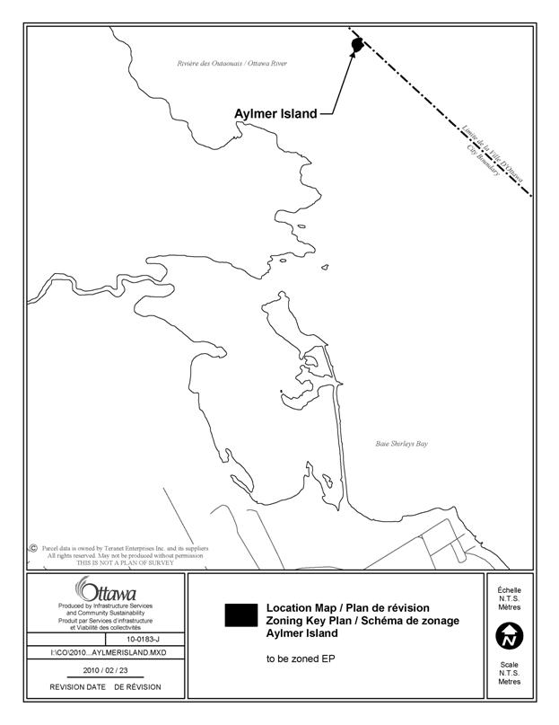
2. Aylmer Island Ward 7 |
Aylmer Island, located in
the Ottawa River, was inadvertently not assigned a zoning code because neither the former
Nepean or West Carleton Zoning By-laws identified this island in their zoning
maps. The Official Plan
designates the island as Natural Environment Area. Threfore the island should
be zoned EP – Environmental Protection to reflect the intent that no
development should occur on this island. |
Amend the Zoning Map, to
zone the subject lands, as shown on Document 2, to EP. |
|
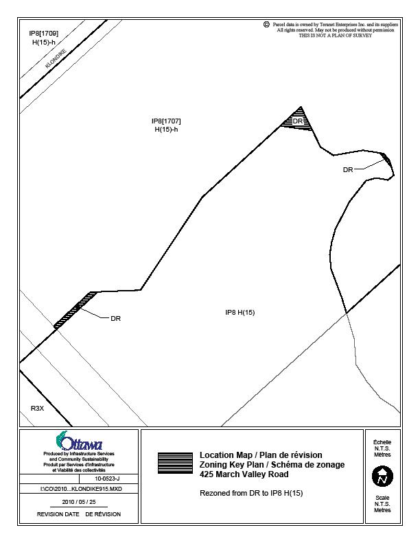
3. Part of 425 March Valley
Road Ward 4 |
The zoning line between the IP8 H(15) zone and the
adjoining DR zone when By-law 2008-250 was adopted followed the zoning line
in the former Kanata Zoning By-law. An
appeal was submitted regarding the DR zoned lands, which was subsequently resolved
through an OMB approved zoning change (OMB order PL080959 dated September 18,
2009) establishing the IP8[1707]-h zone. However, the exact property
boundaries were utilized rather than the former Kanata zoning line to effect
this zoning resolution, which resulted in three small remnant parcels of land zoned DR. |
Amend the Zoning Map, to
rezone the subject lands, as shown on Document 2, from DR to IP8 H(15) |
|
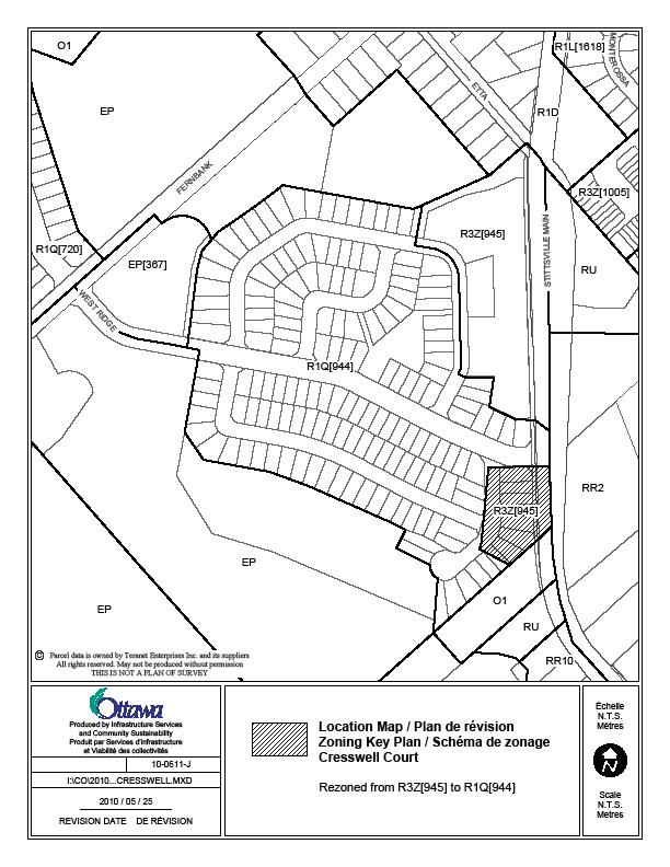
4. Lots from 501 to 515, on
east side and 506 on west side of Cresswell Court Ward 6 |
These lots were part of a
larger single detached dwelling zone under former Goulbourn Zoning By-law,
but were inadvertently mapped with a multiple attached zone similar to the
zone to north. The zoning should be
changed to reflect the adjoining R1Q[944] zone. |
Amend the Zoning Map, to
rezone the subject lands, as shown on Document 2, from R3Z[945] to R1Q[944]. |
|
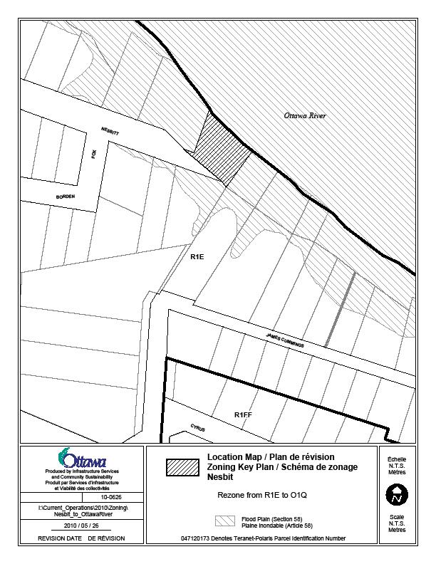
5. Nesbitt Street cul-de-sac
at Ottawa River Ward 7 |
City Council on October 11,
2006 approved a strategy to recognize and protect the public waterfront
recreation access function of selected road allowances on the Ottawa and
Rideau Rivers. Most of the identified
rights-of-ways were rezoned to an O1Q zone through the Comprehensive Zoning
By-law, By-law 2008-250. The right-of-way which forms part of Nesbitt Street,
and is located adjacent to the Ottawa River, was also originally intented to
be rezoned to open space for waterfront access. However, there was
uncertainly as to the ownership of the lands. The ownership issue has now
been resolved and these lands have been determined to be owned by the
City. The lands can now be rezoned as
originally intended. |
Amend the Zoning Map, to
rezone the subject lands, as shown on Document 2, from R1E to O1Q. |
|
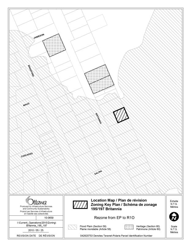
6. 195/197 Britannia Road Ward 7 |
During the former City of Ottawa Planning and Economic
Development Committee public deliberations on the former 1998 draft Zoning
By-law, Committee recommended, and Council approved a motion, “that the ES
zone designation for properties located on the east side of Britannia Road be
changed to an R1G zone in the draft New Zoning By-law.” A mapping error occurred in 1998 when translating the
recommendation into zoning boundaries.
The zoning of the lots located on the east side of Britannia were
identified on two maps, which indicated that all of the lots had been zoned
ES; only one of the two maps identified that the zoning changed to the former
R1G, now R1O. This mapping error was then carried over into the mapping of
the Comprehensive Zoning By-law 2008-250. |
Amend the Zoning Map to rezone the subject lands, as shown
on Document 2, from EP to R1O. |
|
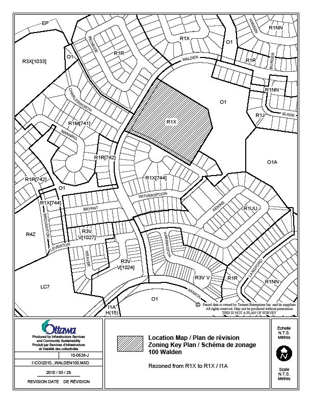
7. 100 Walden Drive Ward 4 |
Kanata
Zoning By-law 167-93 had a dual Institutional/Residential zone (I/R1D-2) on
the lands, as the block of land on the plan of subdivision had been
identified as a potential school site for many years. Zoning By-law 2008-250 carried over the
residential zoning, but the dual institutional zoning was inadvertently not
placed on the zoning map. |
Amend the Zoning Map to rezone the subject lands, as shown
on Document 2, from R1X to R1X/I1A. |
|
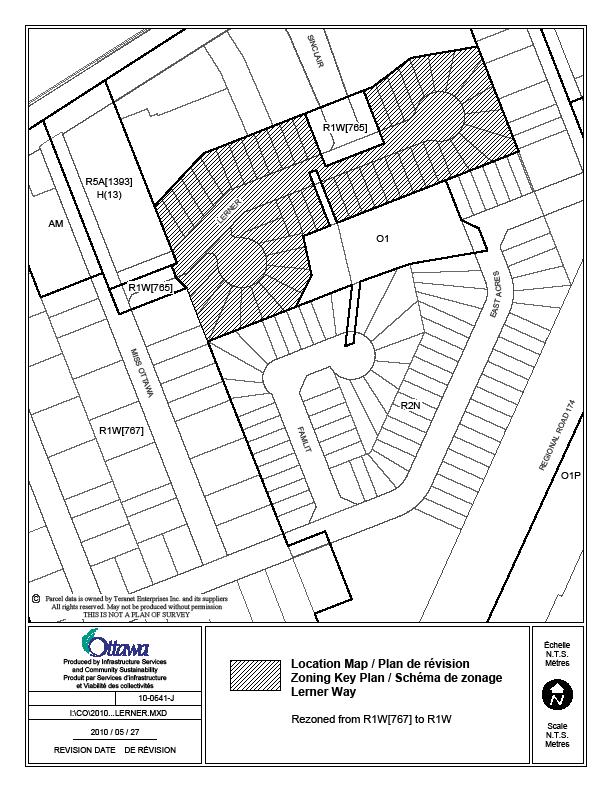
8. Lerner Way Ward 11 |
Lands
along Lerner Way were zoned Rs1 under the former Gloucester Zoning By-law,
and lands to the west were zoned Rs2(E20).
However, the short zoning line between the two zones was missed during
the preparation of zoning mapping for the Comprehensive Zoning By-law, and so
the R1W[767] zone in By-law 2008-250 representing the Rs2(E20) zone, carried
over to the Rs1 zoned lands which should have been zoned R1W. |
Amend the Zoning Map to rezone the subject lands, as shown
on Document 2, from R1W[767] to R1W. |
|
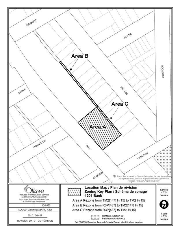
9. Part of 1201 and part of 1159 Bank Street Ward 17 |
During the implementation of zoning provisions for the lands along Bank Street in 2003, the zoning boundary for the property known as 1189-1159 Bank Street inadvertently included part of 1201 Bank Street as well, where the provision contained in exception [147] was not relevant. It is recommended that exception [147] be removed from 1201 Bank Street. As well, the zoning boundary along the rear of all
properties does not co-incide with the rear property line. |
Amend the
Zoning Map to rezone the subject lands, as shown on Document 2 as follows: Area A –
TM2[147] H(15) to TM2 H(15) Area B –
R3P[487] to TM2[147] H(15) Area C –
R3P[487] to TM2 H(15) |
|
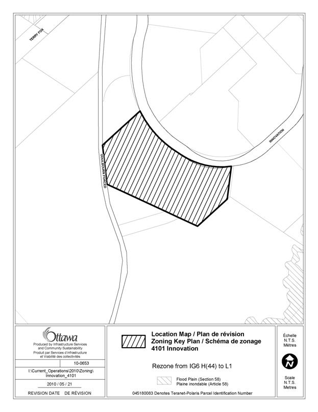
10. 4101 Innovation Drive Ward 4 |
These lands were purchased by the City in November of 2007, through a property acquisition report approved by Council, for the purpose of building a recreation complex for the North Kanata and West Carleton areas. A community centre was a permitted use at the time of the purchase of the land, as the former Kanata Zoning By-law 132-93 permitted a recreational or cultural facility, including an assembly hall or park, intended to serve local needs. These community centre-related uses, other than “place of assembly”, were not carried forward in the current IG6 H(44) zone. Under Comprehensive Zoning By-law 2008-250, the L1 - Community Leisure Facility Zone was applied on a consistent basis to lands where community centres are located. As such, this site should have been zoned L1, consistent with the zoning of other City-owned lands that are the location of a community centre. As these lands are within the General Urban Area, rather than in an Employment Area designation, an L1 zone will be in conformity with Official Plan policies.
|
Rezone the subject lands
from IG6 H(44) to L1, as shown In Document 2.
|
|
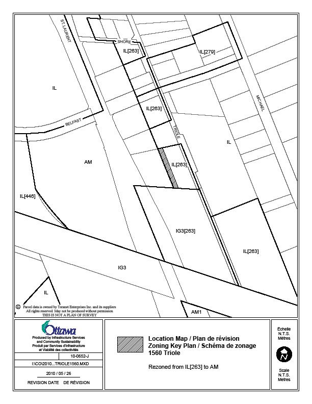
11. 1560 Triole Ward 18 |
The subject property is split between the AM, Arterial Mainstreet zone along St. Laurent Boulevard, and the IL[263], Light Industrial zone along Triole. The zoning line between two zones has existed since Zoning By-law AZ-64 of the former Ottawa Zoning By-law. However, now that the zoning boundaries can be viewed together with air photography and parcel information, the zoning boundary is shown to straddle a small portion of the rear part of the existing building. Since most of the building is located in the AM zone, it is appropriate to move the AM zone boundary slightly to the east, so that the building is entirely within one zoning designation. |
Amend the Zoning Map, to
rezone the subject lands, as shown on Document 2, from IL[263] to AM. |
|
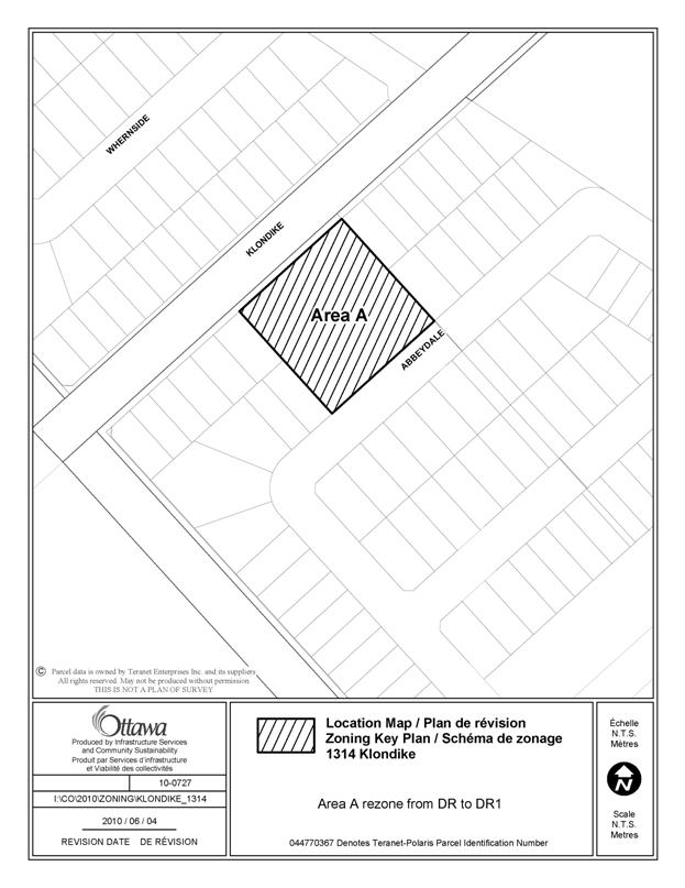
12. 1314 Klondike Road Ward 4 |
This site is zoned DR – Development Reserve which is intended for the future development of lands and does not permit existing dwellings. Under former By-law No. 552 of Kanata, which originates from 1953, the existing dwelling unit was permitted but there was no zoning designation attached to the lands. The lot is surrounded by a new subdivision which has been zoned for detached dwellings. It is appropriate to recognize the existing relatively newly constructed detached dwelling by using the DR1 subzone instead, which would recognize the existing detached dwelling. |
Amend the Zoning Map, to
rezone the subject lands, as shown on Document 2, from DR to DR1. |
Zoning Map and Text
Corrections
|
||
|
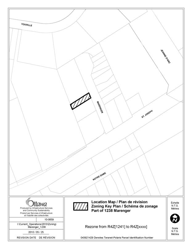
13. Lands between 1238 and
1258 Marenger Ward 1 |
In 2005, 1238
Marenger was rezoned under former Gloucester ZBL 333 of 1999, as Ra1
(E49). The site-specific regulations
affecting duplexes and quadruplexes were carried forward as Exception [1241]. In 2009, a portion of the site was
intended to be rezoned, to delete the existing site-specific regulations and
replace them with regulations affecting planned unit developments. Although only the northern 2/3 of the site
was intended to be rezoned, the entire site was rezoned. As such, the southern 1/3 of the lot was
encompassed within the 2009 amendment when it should not have been, and the
regulations affecting duplexes were deleted in error, with PUD regulations
also not intended to apply to the southern portion. The bottom 1/3 of the lot, as detailed in
Document 2, should be rezoned to reinstate the zoning that was granted under
the by-law 2005-339, and as carried forward in the Zoning By-law 2008-250 on
June 25th, 2008. |
Create and apply a new exception R4Z[XXXX], on the lands
identified in Document 2, with Column II to indicate the zone code R4Z[XXXX],
and include the following provisions in Column V: -minimum lot area for a duplex dwelling is 440 m2 -minimum lot width for a duplex dwelling is 10 m -for a duplex dwelling, the minimum interior side yard
setback is 1.2m and the minimum rear yard setback is 7 m -minimum amenity area rquirement for a duplex dwelling,
stacked dwelling and apartment dwelling, low rise of 4 units is 70 m2 -minimum private amenity area requirement for duplex
dwelling, stacked dwelling and apartment dwelling, low rise of 4 units is 4 m2
per dwelling unit with a 2 m clear diameter -minimum parking requirement for duplex dwelling, stacked
dwelling and apartment dwelling, low rise of 4 units is 1.5 spaces per
dwelling unit -maximum building height for duplex dwelling, stacked
dwelling and apartment dwelling, low rise of 4 units is 11 m Amend the Zoning Map to rezone lands, identified in
Document 2, from R4Z[1241] to R4Z [xxxx]. |
|
14. Lots on west side of
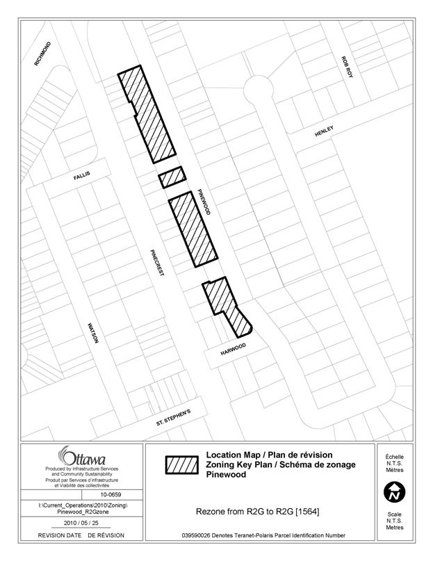
Pinewood Crescent in Queensway Terrace North Ward 7 |
There was an error
in transferring of the area-specific zoning amendment 2006-446 into the
former Ottawa Zoning By-law (ZBL) 93-98 that implemented the Queensway
Terrace North Interim Control study and zoning amendment. The zoning by-law amendment rezoned lands
along the west side of Pinewood Crescent (and the east side) to the
former Exception [961], but that was not carried forward into former Ottawa
ZBL 93-98. When the
consolidated version of ZBL 93-98 was transferred to the new Zoning By-law
2008-250, the exclusion, or anomaly was carried forward. The boundary
for the area-specific zoning should be the rear of the lots fronting on both
sides of Pinewood Crescent. Further, the three
site-specific exceptions along the west side of Pinewood Crescent, formerly
zoned with exceptions [41], [26], and [27] were carried forward as Exceptions
[538], [513], [514], however, the condition restricting rear yard parking, as
per By-law 2006-446 was not, and so needs correction. |
Amend the zoning map for all lots fronting on the most
western side of Pinewood Crescent as shown on Document 2 and currently zoned
R2G, from R2G to R2G [1564] Amend Section 239, Exceptions [513], [514] and [538] to add the following
conditions, in Column V – Provisions; For Exceptions
[513] and [514]: “-no person may
park a passenger vehicle in a rear yard, unless such parking is in a legally
provided garage with direct access from the public street to the garage”; For Exception
[538] add the following provision: “-no person may
park a passenger vehicle in a rear yard on a lot fronting on Pinewood
Crescent, unless such parking is in a legally provided garage with direct
access from the public street to the garage.” |
|
Text
Corrections |
||
|
15. Booth Street, north of
Albert Street, Fleet Street and north side of Albert Street Ward 14 |
The GM7 and GM17 subzones
and exception zones were originally the CN9 and CG16 subzones and exception
zones of former Ottawa Zoning By-law 93-98.
By-law 2000-5 amended By-law 93-98 to bring into force the zoning for
the Central Area, including the Lebreton Flats lands. The recommendations
approved by City Council in August 4, 1999, intended that the maximum floor
space index that normally applied to the CN and CG zones, was not to apply
for these commecial zoned lands in Lebreton Flats. While the implementing
By-law for the Central Area, By-law 2000-5 correctly implemented this
recommendation for the CN9 subzone, it did not for the CG16 subzone. When
these zones were transferred to the applicable GM subzones in By-law
2008-250, a floor space index was imposed where it should not have been to
reflect former City of Ottawa Council’s original intent. Additionally with respect
to the drive-through facility use, the zoning of these lands in the former
Ottawa Zoning By-law 93-98 specifically prohibited drive through facilities,
but this intent was not carried over in the application of the new GM
subzones in By-law 2008-250. |
Amend subsection 188(7) and
188(17) by adding a new clause immediately following 188(7)(b) and 188(17)(a)
which states in effect “a drive-through facility is prohibited” and
relettering clauses 188(7)(c) and 188(17)(b) accordingly.. Amend Tables 188B and 188D
to insert after row (viii) and row (vii) respectively, a new row that
contains in effect the following: In column I the text “(ix)
Maximum floor space index” and in column II the text “no maximum” and
renumber subsequent rows accordingly. |
|
16. Driveway width
provisions for Rockcliffe Park Ward 13 |
An amendment in the March 23, 2010 anomaly report regarding maximum driveway width in Rockcliffe Park did not include vehicular accesses that do not access a legal parking space in the maximum driveway width provisions. Clarification is needed to confirm that vehicular accesses that do not provide access to a legal parking space are subject to driveway width provisions for Rockcliffe Park. These provisions require that the maximum driveway width is 3.05 metres at the street lot line, and in the case of lots with a semi-circular driveway, the maximum driveway width for all accesses combined must not exceed 6.1 metres. The Private Approach By-law
prohibits vehicular accesses that lead to an illegal parking
space. For this reason, circular
driveways that lead to an illegal parking space, in a front yard for example,
are not permitted. However, circular
driveways that lead to a parking space in a location that is permitted by the
Zoning By-law are permitted. It
is possible to obtain a waiver to the Private Approach By-law. As such, an additional provision is needed
in the Zoning By-law to include vehicular accesses that do not lead to the
required parking space for the dwelling in the combined maximum width of
vehicular accesses at the lot line. |
Regarding Section 239 – Urban exceptions, amend Column V of
the following exceptions: R1A[1256], R1A[1257], R1B[1259], R1BB [1258], R1C [1260],
R1I [1261], R3B [907], and R4N[1321] H(12.5), R1I [1262], R4N[1739] by deleting the following provisions: - maximum driveway width is 3.05
m at the street lot line, and in the case of a semi-circular driveway, the
maximum driveway width, for both accesses combined, must not exceed 6.1
metres
And by adding the following provisions: -maximum width of a vehicular access at a lot line is 3.05 metres -the maximum combined width at the lot line of all vehicular accesses is 6.1 metres -despite the preceding provision, vehicular accesses from public lanes are not to be included in the calculation of the maximum allowable combined width of all vehicular accesses at the lot line -minimum landscaped strip of 1.5 metres, developed with
soft landscaping, is required between the interior side lot line and a
vehicular access |
|
17. Laporte Street Ward 11 |
This R1W exception 767 zone is intended to reflect the former Gloucester Rs1(E20), single detached dwelling zone. The exception permitted as additional uses, a semi-detached and duplex dwelling, but not on vacant lots. While new exception 767 reflects the former Gloucester exception, additional clarification is required to deal with existing duplexes and semi-detached dwellings and confirm which performance standards are applicable for semi-detached and duplex dwellings since the R1 zone performance standards are only specified for detached dwellings. |
Amend Section 239,
Exception 767, Column V, Provisions, by adding the following: - only semi-detached
dwellings and duplex dwellings that existed on June 25, 2008 are permitted - these dwellings can be
renovated, repaired or replaced but no new semi-detached or duplex dwellings
can be created or constructed - minimum interior side
yard setback is deemed to be 0 between individual units in a semi-detached
dwelling - a duplex dwelling and
each dwelling unit in a semi-detached dwelling are subject to the provisions
of Table 156A, Subzone W |
|
18. Table 111B – Bicycle
Parking Space Dimensions |
Amend Section 111, Table 111B – Row (b), Column
III, to delete the number 0.6 and replace it with the number 1.5. |
|
|
19. Definitions – Light
Industrial Use, Heavy Industrial Use |
The “light industrial use”
or “heavy industrial use”, and “warehouse” are defined land uses which
together are permitted in many industrial areas. The storage and distribution
of materials and products, when not accessory to the manufacting and
processing of those products, falls under the “warehouse” land use. Storage
or distribution of products accessory to their production or manufacturing
within the same building or on the same site falls under the “light” or
“heavy” industrial use. Therefore
reference to this accessory function is not required in the definitions of
light and heavy industrial use. As well, under the heavy
industrial use definition, the word “or” is needed between (a) and (b) and
the word “; and” should be deleted to clarify that one of the two functions
can take place, both need not take place together for a heavy industrial use.
|
Amend the
definition of “light industrial use” in Section 54 by deleting clause (a) and relettering clauses (b), (c) and (d)
accordingly. Amend the definition of “heavy industrial use” in
Section 54 as follows: (i) by deleting the word “and” at the end of clause (b); (ii) by replacing the text “;” with “.” at the end of clause
(b); (iii) by inserting the word “or” at the end of clause (a); and, (iv) by deleting clause (c). |
LIST OF SITE-SPECIFIC
LOCATION MAPS DOCUMENT
2
|
Location Maps (attached) |
|
Aylmer Island |
|
425 March Valley
Road |
|
Lots from 501 to 515 on east side, and 506 on west side, of Cresswell Court |
|
Nesbitt Street cul-de-sac
at Ottawa River |
|
195 (and 197) Britannia
Road |
|
100 Walden Drive |
|
Lerner Way |
|
Part of 1201 and part of 1159
Bank Street |
|
4101 Innovation Drive |
|
1560 Triole |
|
1314 Klondike Road |
|
Lands between 1238 and 1258
Marenger |
|
Lots on west side of
Pinewood Crescent in Queensway Terrace North |