|
6. ZONING - PART OF 4419 4TH
LINE ROAD |
Committee
Recommendation
(This application is subject to the provisions of Bill 51.)
That Council approve an amendment to the Zoning By-law 2008-250 to
change the zoning for Part of 4419, 4th Line Road from Agricultural
Subzone 2 (AG2) to Agricultural Subzone 6, (AG6) as shown in Document 1.
Recommandation DU Comité
(Cette application est
assujettie aux dispositions du Règlement 51.)
Que le Conseil approuve une modification
au Règlement 2008-250 sur le zonage, de façon à faire passer la désignation de
zonage d’une partie de la propriété située au 4419, chemin 4th Line de
sous-zone agricole 2 (AG2) à sous-zone agricole 6 (AG6), comme l’illustre le
document 1.
Documentation
1. Deputy City Manager’s Report,
Infrastructure Services and Community Sustainability dated 5 August 2010
(ACS2010-ICS-PGM-0140).
Report to/Rapport au :
Agriculture and Rural Affairs Committee
Comité
d'agriculture et des affaires rurales
and Council / et au Conseil
05 August 2010 / le 05
août 2010
Submitted by/Soumis par :
Nancy Schepers, Deputy City Manager/Directrice
municipale adjointe, Infrastructure Services and Community
Sustainability/Services d’infrastructure et Viabilité des collectivités
Contact
Person/Personne-ressource : Derrick Moodie, Manager/Gestionnaire, Development
Review-Rural Services/Examen des projets d'aménagement-Services ruraux, Planning
and Growth Management/Urbanisme et Gestion de la croissance
(613)
580-2424, 15134 Derrick.Moodie@ottawa.ca
|
SUBJECT: |
ZONING
- Part of 4419 4th Line Road (FILE NO. D02-02-10-0057) |
|
|
|
|
OBJET : |
REPORT RECOMMENDATION
That the
Agriculture and Rural Affairs Committee recommend Council approve an amendment
to the Zoning By-law 2008-250 to change the zoning for Part of 4419, 4th
Line Road from Agricultural Subzone 2 (AG2) to Agricultural Subzone 6, (AG6) as
shown in Document 1.
RECOMMANDATION
DU RAPPORT
Que le Comité de l’agriculture et des affaires
rurales recommande au Conseil d’approuver une modification au Règlement 2008-250
sur le zonage, de façon à faire passer la désignation de zonage d’une partie de
la propriété située au 4419, chemin 4th Line de sous-zone agricole 2
(AG2) à sous-zone agricole 6 (AG6), comme l’illustre le document 1.
BACKGROUND
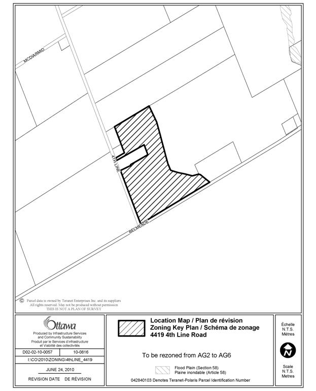
The subject parcel is known as Part of 4419, 4th Line Road. The approximately 21 hectare parcel is on the northeast corner of the 4th Line Road and Belmeade Road intersection. The property is adjacent to agriculturally zoned lands to the north, west and east and across Belmeade Road to the south, in the Municipality of North Dundas, are also agricultural lands. The lands that are intended to be rezoned constitute the “retained” agricultural lands on a recent consent application.
Purpose of Zoning Amendment
The rezoning is to fulfill a condition of the Committee of Adjustment decision to sever a 1.45‑hectare parcel containing a dwelling unit made surplus through farm consolidation.
The existing zoning of the severed and retained properties is Agricultural Subzone 2 (AG2). The existing zone recognizes and permits agricultural uses in areas designated “Agricultural Resource Area” in the Official Plan and restricts the range of permitted uses to agricultural, forestry and related accessory uses, in order to preserve these prime agricultural lands from loss to other uses. The Subzone 2 refers to an agricultural parcel that is a minimum of 18 hectares with a minimum lot width of 60 meters.
The retained lands are intended to be zoned Agricultural Subzone 6 (AG6). This zoning permits agricultural uses in areas designated “Agricultural Resource Area” as above but prohibits a detached dwelling. This particular subzone represents agricultural lands with a minimum area of 18 hectares and a minimum lot width of 60 metres.
DISCUSSION
The parcel is designated Agricultural Resource in the Official Plan. The policies permit severance of a dwelling unit made surplus through farm consolidation, provided the vacant agricultural parcel is rezoned to prohibit any residential use.
The Committee of Adjustment in granting the severance of the dwelling unit has required, in accordance with the Official Plan, the retained lands to be rezoned, prior to finalization of the consent. The proposed zoning therefore implements the intent of the Official Plan.
In accordance with the Provincial Policy Statement and the Official Plan, the Committee of Adjustment required that the retained vacant farmland be rezoned to prohibit future residential dwellings.
The Zoning By-law sets up specific zones that prohibit residential uses for these circumstances, depending on the area and lot width associated with the final parcel configuration. In this case the retained parcel is approximately 20.6 hectares in area with an approximate lot width of approximately 392 metres. The Agricultural Subzone 6 sets a minimum lot area of 18 hectares and minimum lot width of 60 metres.
RURAL IMPLICATIONS
The rezoning supports the agricultural community, permitting a farmer to dispose of a dwelling surplus to his operation, while protecting and preserving the agricultural use of the retained lands, by prohibiting future dwellings to be constructed thereon.
CONSULTATION
Notice of this application was carried out in accordance with the City's Public Notification and Consultation Policy. The City did not receive any negative comments or opposition to this application.
COMMENTS BY THE WARD COUNCILLOR(S)
The Ward Councillor is aware of this application and the staff recommendation.
LEGAL/RISK MANAGEMENT IMPLICATIONS
There are no legal/risk management implications associated with this report.
CITY STRATEGIC PLAN
N/A
TECHNICAL IMPLICATIONS
N/A
FINANCIAL IMPLICATIONS
There are no direct financial implications associated with this report.
APPLICATION PROCESS TIMELINE STATUS
This application was processed by the "On Time Decision Date" established for the processing of Zoning By-law amendment applications.
SUPPORTING DOCUMENTATION
Document 1 Location Map
DISPOSITION
City Clerk and Solicitor Department, Legislative Services to notify the owner, applicant, OttawaScene.com, 174 Colonnade Road, Unit #33, Ottawa, ON K2E 7J5, Ghislain Lamarche, Program Manager, Assessment, Financial Services Branch (Mail Code: 26-76) of City Council’s decision.
Planning and Growth Management to prepare the implementing by-law, forward to Legal Services and undertake the statutory notification.
Legal Services to forward the implementing by-law to City Council.
LOCATION MAP DOCUMENT
1