Committee RecommendationS AS AMENDED
That Council:
1. Approve the recommended corridor functional design alignment and station alternatives for the Hospital Link and the Cumberland Transitway Westerly;
2. Direct staff to initiate the formal Environmental Assessment process based on the functional design, in accordance with the Ontario Environmental Assessment Regulation 231/08 for transit projects;
3. Direct staff to initiate the property acquisition, subject to the completion of the Environmental Assessment process and annual capital budget approval; and
4. Direct that noise attenuation measures be evaluated during the Environmental Assessment process to provide relief to abutting residents and appropriate berms / barriers be considered for implementation.
Recommandations MODIFIÉES DU COMITÉ
Que le Conseil :
1. approuve le tracé de conception fonctionnelle du couloir recommandé et le choix des stations pour le tronçon ouest du Transitway à Cumberland et la correspondance vers l’hôpital;
2. demande au personnel d’entreprendre le processus officiel d’évaluation environnementale de la conception fonctionnelle, conformément au Règlement 231/08 sur l’évaluation environnementale de l’Ontario pour les projets de transport en commun;
3. demande au personnel d’entreprendre l’acquisition des propriétés après le processus d’évaluation environnementale et l’approbation du budget annuel des immobilisations; et
4. demande que des mesures d’atténuation du bruit soient évaluées durant le processus d’évaluation environnementale afin d’apporter un soulagement aux résidents adjacents et que l’installation de levées de terre et de barrières appropriées soit envisagée.
Documentation
1. Deputy City Manager’s report dated 30 July 2010 (ACS2010-ICS-PGM-0155)
2. Extract of Draft Minutes 48, Transit Committee meeting of 30 August 2010
Report to/Rapport au :
and Council / et au Conseil
30 July 2010 / le 30 juillet 2010
Submitted by/Soumis par : Nancy Schepers, Deputy City Manager/Directrice municipale adjointe, Infrastructure Services and Community Sustainability/Services d 'infrastructure et Viabilité des collectivités
Contact/Personne ressource : Vivi Chi, Manager/Gestionnaire, Transportation Planning/Planification des transports, Planning and Growth Management/Urbanisme et Gestion de la croissance
(613) 580-2424 x 21877, Vivi.Chi@ottawa.ca
REPORT RECOMMENDATIONS
That the Transit Committee recommend Council:
1. Approve the recommended corridor functional design alignment and station alternatives for the Hospital Link and the Cumberland Transitway Westerly;
2. Direct staff to initiate the formal Environmental Assessment process based on the functional design, in accordance with the Ontario Environmental Assessment Regulation 231/08 for transit projects; and
3. Direct staff to initiate the property acquisition, subject to the completion of the Environmental Assessment process and annual capital budget approval.
RECOMMANDATIONS DU RAPPORT
Que le Comité du transport en commun recommande au Conseil :
1. D’approuver le tracé de conception fonctionnelle du couloir recommandé et le choix des stations pour le tronçon ouest du Transitway à Cumberland et la correspondance vers l’hôpital;
2. De demander au personnel d’entreprendre le processus officiel d’évaluation environnementale de la conception fonctionnelle, conformément au Règlement 231/08 sur l’évaluation environnementale de l’Ontario pour les projets de transport en commun; et
3. De demander au personnel d’entreprendre l’acquisition des propriétés après le processus d’évaluation environnementale et l’approbation du budget annuel des immobilisations.
Executive Summary
Assumptions and Analysis
On 02 July 2008 Transit Committee approved the Statement of Work for the Hospital Link Transit Corridor Planning and Environmental Assessment (EA) Study. A Planning and EA Study to address the Browning Corridor issue was initiated following Council’s approval of the updated 2008 Transportation Master Plan (TMP) and to address the Ontario Municipal Board decision that ordered the EA be completed by no later than 31 December 2009. An additional motion was carried that included that the boundary of the EA Study be amended, north and south, to include the Belfast Road, Industrial Avenue and Smyth Road corridors, and that the study area be extended to include a corridor connection to the existing Cumberland Transitway Corridor; and that it be coordinated with the TMP Update.
On 28 October 2009 Council received a report indicating that the Browning Corridor would be removed from consideration as a future rapid transit corridor due primarily to the high cost of relocating hydro towers and local impacts to residents. Alternative transit connections to the Hospital lands continued to be investigated as the study progressed, along with the examination of corridors for the Cumberland Transitway Westerly (from Navan Road to Blair Station).
Alignment options and station alternatives were developed for the approximately 13 km, (16‑station) alignment, which is composed primarily of on-street facilities from the Hospital Lands to the Southeast Transitway, from Hurdman Station to Blair Road at Innes Road and a segregated Transitway from Navan Road to Blair Station. Figure 5 shows the recommended corridor. Document 1 contains the Functional Design plans for this corridor.
During the early stages of the study it was determined that ridership projections to 2031 varied greatly over the length of the project area. Along Innes Road (west of Blair Road) the projected ridership volumes were much lower than the section north along Blair Road and to the east along Innes Road. A completely segregated transit facility would not be required west of Blair Road based on these 2031 ridership projections. Bus lanes, queue jumps, and transit signal priority are recommended instead.
This project has a number of potential triggers that may require the completion of a federal EA under the Canadian Environmental Assessment (CEAA). These include the requirement for federal land, and potential federal funding. Early contact was made with the CEAA who identified the National Capital Commission (NCC) as the anticipated federal Responsible Authority.
Legal/Risk Management Implications
There are no legal/risk management impediments to implementing this report's recommendations.
Technical Implications
N/A
Financial Implications
The preliminary project cost estimate to design and construct the Hospital Link and Cumberland Transitway Westerly is approximately $340.0 M in 2010 dollars, unescalated.
The following provides a cost breakdown in 2010 dollars:
·
Construction – Hurdman Station to Blair Station and Cumberland
Transitway Westerly (13km) $210
M
· Design, Project Management, Construction Administration (30%) $ 62 M
· Property Acquisition $ 15 M
· Project Contingency (20%) $ 53 M
$340 M
Funding for these works will be requested at the appropriate time, as part of the annual Capital Budget process cycle to be approved by Council.
Funding for the environmental assessment process is provided for in Capital Account 902135 (Rapid Transit EA Studies).
Public Consultation/Input:
Extensive public and agency stakeholder consultation has taken place to date which included two public open houses (April 2009 and June 2009) in which a total of 170 people attended; a transit corridor alternatives evaluation workshop; Agency, Public and Institutional Consultation Group meetings; and, various invidual stakeholder group meetings (the National Capital Commission, the Ministry of Transportation of Ontario (MTO), the Ottawa Trainyards, Pineview Golf Course and the Hospital Lands). Information from the study has been posted on the city’s web site:
http: /www.ottawa.ca/residents/public_consult/hospital_cumberland/index_en.html.
In summary, the public consultation provided valuable feed-back on: transit ridership patterns, safety concerns, property access and propery impact, noise and vibration levels, pedestrian and cycling movements and concerns with respect to community greenspace.
Agency and Institutional consultation provided valuable feedback on: minimizing effects on the greenbelt and avoiding impacts on; development, Highway 417 interchange, golf course operations and parking with respect to the Hospital Lands.
RÉSUMÉ
Hypothèses et analyse
Le Comité des services de transport en commun a approuvé le 2 juillet 2008 l’énoncé de travail de l’étude d’évaluation environnementale (EE) et de planification du couloir de transport en commun et de la correspondance vers l’hôpital. Une étude de planification et d’EE pour considérer la question du couloir de l’avenue Browning a été entreprise après approbation au Conseil du Plan directeur des transports (PDT) 2008 mis à jour et en réponse à la Commission des affaires municipales de l’Ontario qui a ordonné que l’EE soit achevée le 31 décembre 2009 au plus tard. Une motion supplémentaire adoptée demandait, notamment, que les limites de l’étude d’EE soient modifiées au nord et au sud pour ajouter les couloirs du chemin Belfast, de l’avenue Industrial et du chemin Smyth, élargir les secteurs à l’étude pour comprendre une correspondance vers le couloir actuel du Transitway à Cumberland et que le tout soit coordonné selon le PDT mis à jour.
Le Conseil a reçu un rapport le 28 octobre 2009 indiquant que le couloir de l’avenue Browning serait supprimé des considérations comme couloir de transport en commun rapide à l’avenir, surtout à cause des coûts élevés du déplacement des tours d’hydroélectricité et des répercussions locales sur les résidents. D’autres correspondances de transport en commun vers les terrains de l’hôpital ont continué de faire l’objet d’une enquête pendant l’étude, simultanément à l’examen de couloirs pour le Transitway ouest à Cumberland (du chemin Navan à la station Blair).
Les options du tracé et le choix des stations ont été élaborés pour les 13 km environ, le tracé (16 stations) composé surtout d’installations à la rue à partir des terrains de l’hôpital jusqu’au Transitway sud-est, de la station Hurdman aux chemins Blair et Innes et un tronçon distinct du chemin Navan à la station Blair. Le couloir recommandé est affiché à la figure 5. Les plans de conception fonctionnelle de ce couloir sont versés au Document 1.
Il a été déterminé aux premières étapes de l’étude que les prévisions de l’achalandage jusqu’en 2031 varient énormément d’un bout à l’autre du secteur du projet. Le long du chemin Innes, à l’ouest du chemin Blair, l’achalandage prévu est beaucoup moindre qu’à la section nord le long du chemin Blair et à l’est le long du chemin Innes. Une installation de transport en commun complètement séparée ne serait pas nécessaire à l’ouest du chemin Blair, compte tenu des prévisions de l’achalandage jusqu’en 2031. Des voies réservées aux autobus, des voies d’évitement et des indications priorité au transport en commun sont plutôt recommandées.
Ce projet comprend des déclencheurs éventuels qui peuvent exiger l’achèvement d’une EE fédérale selon l’Agence canadienne d’évaluation environnementale (ACEE). Ils comprennent des terres fédérales nécessaires et le financement fédéral éventuel. Les premières communications avec l’ACEE ont déterminé que la Commission de la capitale nationale (CCN) est le secteur de compétence fédérale prévu.
Incidences juridiques / concernant la gestion des risques
Il n’y a pas d’incidences juridiques – concernant la gestion des risques qui empêchent l’application des recommandations de ce rapport.
Incidences techniques
s.o.
Répercussions financières
L’estimation préliminaire du coût du projet pour la conception et l’aménagement de la correspondance vers l’hôpital et du tronçon ouest du Transitway à Cumberland est d’environ 340 millions de dollars 2010 non actualisés.
Voici la ventilation des coûts, en dollars de 2010 :
· Construction – de la station Hurdman à la station Blair et le tronçon ouest du Transitway à Cumberland (13 km) 210 M$
· Conception, gestion de projet, administration de la construction (30 %) 62 M$
· Achat de la propriété 15 M$
· Dépenses imprévues liées au projet (20 %) 53 M$
340 M$
Le financement de ces travaux sera demandé au moment opportun, pendant le cycle du processus du budget annuel des immobilisations qui doit être approuvé au Conseil.
Le financement du processus d’évaluation environnementale est assuré par le compte d’immobilisations no 902135 (études d’évaluation environnementale du transport en commun rapide).
Consultation publique / commentaires
Il y a eu des consultations approfondies avec le grand public et des intervenants d’organismes jusqu’à maintenant, y compris deux réunions publiques (avril et juin 2009) et 170 personnes au total y ont assisté, un atelier d’évaluation des choix de couloir de transport en commun, des réunions de groupes de consultation avec des organismes, le public et des établissements, et diverses réunions avec des groupes d’intervenants (Commission de la capitale nationale, ministère des Transports de l’Ontario (MTO), Ottawa Trainyards (gare de triage), terrain de golf Pineview et terrains de l’hôpital). L’information de l’étude est téléchargée au site Web de la ville :
http: /www.ottawa.ca/residents/public_consult/hospital_cumberland/index_fr.html.
Bref, la consultation publique a donné une réaction appréciable sur : les caractéristiques de l’achalandage du transport en commun, les préoccupations que suscite la sécurité, l’accès à la propriété et les répercussions sur la propriété, les niveaux de bruit et de vibration, les déplacements des citoyens et des cyclistes, les préoccupations que suscitent les espaces verts de la collectivité.
La consultation avec les organismes et établissements a donné une réaction appréciable sur : les moyens de minimiser les répercussions sur la ceinture de verdure et d’éviter les incidences sur l’aménagement, l’échangeur de l’autoroute 417, les activités au terrain de golf et le stationnement aux terrains de l’hôpital.
BACKGROUND
In 2006, the Ontario Municipal Board heard an appeal of the City’s 2003 Official Plan (OP) related to Schedule D. Specifically the issue was about the City’s inclusion of a section of the rapid transit network in the vicinity of Browning Avenue (near the Hospital Lands). On 30 November 2006, the Ontario Municipal Board issued a decision and ordered that an EA be conducted and completed by no later than 31 December 2009. The decision also stated that if the EA was not completed as of this date the designation of the Browning corridor as a “Future Rapid Transit Corridor - Alignment” would be deleted from the Official Plan.
On 02 July 2008 Transit Committee approved the Statement of Work for the Hospital Link Transit Corridor Planning and EA Study. A Planning and EA Study to address the Browning Corridor issue was initiated following Council’s approval of the updated 2008 TMP. An additional motion was carried that included that the boundary of the EA Study be amended, north and south, to include the Belfast Road, Industrial Avenue and Smyth Road corridors, and that the study area be extended to include a corridor connection to the existing Cumberland Transitway Corridor; and that it be coordinated with the TMP Update.
On 28 October 2009 Council received a report indicating that the Browning Corridor would be removed from consideration as a future transit corridor. This corridor was discarded mainly due to the high cost of the relocation of the existing Hydro One towers and the potential impact to local residents.
Alternative transit connections to the Hospital lands continued to be investigated as the study progressed, along with the examination of corridors for the Cumberland Transitway Westerly (from Navan Road to Blair Station). This report presents to Transit Committee and Council the recommended corridor. The functional design is described as follows.
DISCUSSION
The Study Area (Figure 1) was divided into five sections in recognition of their different characteristics and to facilitate the assessment and evaluation of corridor and design alternatives. The recommended transit project will be described in relation to these five study sections.
Sections 1 and 2 include the Hospital Link corridor in the TMP while Sections 3 to 5 include the Cumberland Transitway Westerly connection.
Figure 1 – Study Area
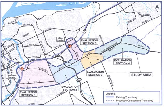
The westerly portion of the Study Area (Sections 1 and 2) provides a significant opportunity for the City to create an intensified and transit-oriented corridor by building on the existing strengths of the employment, retail and residential nodes along it. The easterly portion of the Study Area (Sections 3 to 5), while providing some opportunities for intensification, serves largely as a connecting link to the adjacent communities along Blair Road and Blackburn Hamlet and the sizeable growth area in South Orleans.
Need For Project
The need for the project is founded on the work undertaken for the 2008 TMP. The bus transit corridor elements included as part of this project were envisioned in the TMP to form part of a cross-town east-west bus rapid transit (BRT) corridor. This BRT would start from the Southeast Transitway at Hurdman Station, and head easterly along a new corridor to Innes at Blair. At this point, it would connect with a new corridor through Orleans and link with the Cumberland Transitway (Navan to Frank Kenny). At Innes and Blair, the BRT corridor is also shown heading northerly along Blair to Blair Station, where it would connect to the future LRT to travel towards the downtown (Blair to Tunney’s). This project is the last remaining link to finish EAs for the phase 1, increment 1 projects identified in the TMP. This project will help the City achieve its modal split targets, connect major employment and residential nodes, and support mobility throughout the City.
The City’s long term plan (beyond 2031) is to extend the LRT network from Blair Station both east along Highway 174 and south and east along Blair Road and Innes Road.
The Hospital Link and Cumberland Transitway Westerly will significantly improve transit within the corridor and beyond by removing buses from mixed-traffic and therefore improving travel times and reliability, outcomes which are consistent with the City’s vision for a competitive and sustainable transportation system. These improvements would make transit more attractive, especially to ‘choice’ riders. In addition, it would provide high quality connections to the existing rapid transit network and increase the accessibility of the corridor to the rest of the region.
The projected 2031 transit morning peak hour ridership of between 2600 and 4400 justifies the establishment of higher-order, segregated, transit for some segments of the study area. The peak hour load in the corridor is expected to be approximately 4,400, with the peak point occurring east of Blair Road. This level justifies the separation of transit from mixed traffic. West of Blair Road, the requirement for segregated transit is not satisfied.
The 2008 TMP envisioned that all sections of the current project would be planned as primary elements of the rapid transit network, to be implemented as fully segregated bus rapid transit corridors. The current study has confirmed that a fully segregated transitway standard design for the Cumberland Transitway Westerly portion of the project (from Navan Road to Blair Station) is justified due to projected higher levels of transit ridership. However, due to somewhat lower ridership levels projected for the segment between Blair Road (at Innes Road) and the Hospital Complex, the study recommends a mixture of generally lower exclusivity semi-intensive transit designs.
Corridor Alignment Options
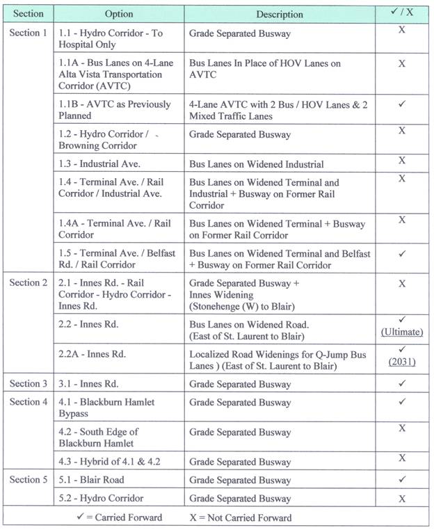
Building on the need for the project and identified level of transit exclusivity for various project sections, potential corridor alignment options were identified and assessed. The process to develop a recommended set of alignments along the corridor was iterative, and included considerable assessment and stakeholder involvement in development and screening of corridor alternatives. The short list of transit corridor options is shown on Figure 2.
Figure 2 – Short list of Corridor Options

Within Section 1 the short list of transit corridor alternatives that would directly serve the hospital lands included: three variations on a ‘Hospital Spur’ including a grade-separated busway and either bus lanes or high occupancy vehicle (HOV) lanes as part of future four-lane Alta Vista Transportation Corridor as well as the Hydro - Browning corridor as proposed in the TMP. In addition, alternative corridors through the industrial lands to the north included: Industrial Avenue, Terminal Avenue - Rail Corridor - Industrial Avenue, Terminal Avenue - Rail Corridor, and, Terminal Avenue - Belfast Road - Rail Corridor.
Section 2 transit corridor alternatives included: the Innes Road - Rail Corridor - Hydro Corridor Innes Road option (which allowed the greatest length of segregated busway and avoided further widening of Innes Road over most of its length), and the Innes Road corridor which included widening of the road for bus lanes (more direct but higher property impact). A variation to the latter option included only localized widenings of Innes Road for bus-only queue jump lanes at a much lower impact and cost.
Within Section 3, only the Innes Road corridor was short listed as other corridors were considered to have relatively greater impacts to the Greenbelt.
For Section 4, the options included: along the Blackburn Hamlet Bypass, along the south edge of the Blackburn Hamlet community, and a hybrid of both.
Section 5 options were considered to follow Blair Road or a Hydro Corridor (to the west of Blair Road). The short listed and recommended options are summarized in Table 1.
Table 1 - Transit Corridor Alternatives Evaluation Summary
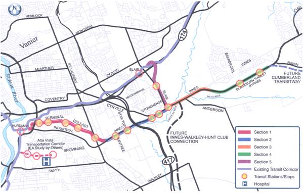
The recommended transit corridors (and station locations) are shown in Figure 3.
Figure 3 - Recommended Corridors and Station Locations
Transit Station Options
In conjunction with the development and selection of recommended transit alignments, concurrent assessments were made of the potential locations, type and form of transit station that should be provided. Factors considered included proximity to residential and employment nodes, transit oriented development (TOD) opportunities, station spacing and transfer requirements.
The recommended form and size of the transit loading / unloading / transfer facilities considered the different levels of segregation of the recommended transit facilities over the various sections of the project corridor. As noted above, these vary from fully segregated (grade-separated) Transitway designs within Sections 3, 4 and 5 to a mix of generally less segregated facilities (mostly bus lanes) in Sections 1 and 2. As a result, the recommended design includes a combination of fully segregated transit stations, at-grade transit stations and bus stops. Further comments regarding transit station options are included below.
Park and ride lots have been identified through the TMP. No new park and ride lots are included within the project limits.
Recommended Plan Overview
The new transit facility will see the construction of approximately 13 km of new busway, bus‑only lanes and a section of transit priority measures extending from Navan Road to Blair Station and from Hurdman Station at the Southeast Transitway to Blair Road. Five major new grade-separated transit stations are proposed along with eight bus stops (not including the three along the Alta Vista Transportation Corridor). Pedestrian and cycling facilities along the individual corridors and connectivity between the transit stations / stops and adjacent residential and employment nodes will be accommodated through a combination of sidewalks, multi-use pathways and/or on-road cycling lanes as described below and depicted on the attached Recommended Functional Design Plans (Document 1).
A summary of the recommended plan is as follows:
· Section 1-1 Hospital Spur (1.1 km) - The study concludes that this transit link would be served well by the design already recommended through the approved Alta Vista Transportation Corridor (AVTC) EA Study (2005), which provides for one mixed traffic lane and a Bus / High Vehicle Occupancy (HOV) lane in each direction. The design also includes bus-pockets at key intersections to ensure good level of service for both transit and HOV uses. Enhanced pedestrian linkages between the hospital lands and the transit service on the AVTC corridor are an important element of the plan (and could ultimately include grade separated connections). The AVTC EA study identified bus stops at the signalized Alta Vista Drive intersection. Bus stop locations at the former National Defense Medical Centre and Ottawa Hospital access roadways is being confirmed through the preliminary and detail design process for that project.
· Section 1 Hurdman Station to Innes Road (3.5 km) - The recommended plan includes a combination of road widenings for bus lanes on Terminal Avenue and Belfast Road as well as a segregated busway on the former rail corridor in the area of St. Laurent Blvd. Widening of the Terminal Avenue Bridge over Riverside Drive is required. Grade separations will be provided at the existing St. Laurent Blvd. rail underpass where a new transfer station would be provided and at the existing Innes Road rail overpass (for eastbound buses). Bus stops are also recommended on Terminal Avenue (west of Caledon Place), Trainyards Drive (at Terminal Avenue), and on Belfast Road (west of St. Laurent Blvd.).
· Section 2 - Innes Road - Bantree Street to Blair Road (2.2 km) - The long term ‘ultimate’ (post-2031) recommended plan includes right-of-way protection for the outside widening of Innes Road by one lane in each direction to accommodate new curb side (outer) bus lanes, cycling lanes and sidewalks where none exists. West of Highway 417, Innes Road is currently 4 lanes and right-of-way width generally exists for widening (although some significant retaining walls structures would be required). East of Highway 417, however, Innes Road is currently six lanes and adding additional width throughout is costly and comes with relatively high property impacts which makes it difficult to justify at this time given the lower projected transit ridership. As such it is recommended not to provide a full widening of Innes Road from Bantree Street to Blair Road within the horizon of the current TMP but rather to protect the right-of-way required for this scenario in the long term - beyond 2031. The recommended 2031 plan includes localized widenings to accommodate bus-only queue jump lanes with transit signal priority at intersections along Innes Road eastbound at the southbound Highway 417 off-ramp and between Cyrville Road and Stonehenge Crescent (East) as well as westbound from east of Cyrville Road to the east-to-north on-ramp to Highway 417. Bus stops are proposed at Bantree Street, Startop Road, Cyrville Road, and at Stonehenge Crescent (East).
· Section 3 - Innes Road (at Blair Road) to Blackburn Hamlet Bypass (1.8 km) - The recommended plan includes a widening to the south and the shifting of the current roadway southward to permit a fully segregated two-lane Transitway to be located along the existing westbound lanes of Innes Road which will connect to a key transfer station at the Innes Road / Blair Road intersection. The proposed future new intersection for the Innes-Walkley Extension has been considered as part of the recommended plan. The ultimate east to south grade-separated ramp connection from Innes Road westbound to the Innes Walkley Extension planned on the north side of this intersection can be deferred beyond the 2031 planning horizon by providing a westbound double left turn lane. At the easterly end of this section, it is proposed that the Transitway pass through the intersection of Innes Road at Blackburn Hamlet in a grade-separated underpass with retaining walls provided to limit encroachment to nearby recreational facilities. In order to ensure direct bus access from Blackburn Hamlet to the Transitway at this location, a bus-only connection from Pepin Court is proposed.
· Section 4 - Blackburn Hamlet Bypass (2.4 km) - The recommended plan includes expanding the roadway right-of-way to the south side, constructing new eastbound lanes for the Blackburn Hamlet Bypass while shifting the existing westbound lanes south onto the existing eastbound lanes. The plan also protects for a future 6-laning into the median of the Bypass. The two-lane Transitway would be located along the north side of the right-of-way within what are now the existing westbound lanes of the Blackburn Hamlet Bypass. At its easterly end, the transit facility will join with the Cumberland Transitway near Navan Road (currently under detail design) in accordance with the recommendations of the approved Cumberland Transitway EA Study (2000). Two on-line transit stations are provided along this section.
· Section 5 - Blair Road - Innes Road to Blair Station (2.0 km) - North of Innes Road, the Transitway is proposed between Blair Road and the Pineview Golf Course. An at-grade transit station is planned for the northeast quadrant of Blair Road and Innes Road. An on‑line transit station is proposed at Meadowbrook Road and Blair Road, as the last stop prior to crossing Highway 174 and joining onto the East Transitway and Blair Station where the future light rail transit (LRT) system is to begin the service to downtown. The two existing access locations to the Golf Course parking and circulation are proposed to be consolidated into one signalized access opposite Meadowbrook Road. The Transitway will cross beneath this intersection and retaining walls would be required along this open-cut portion of the Transitway. North of the Meadowbrook Station, the Transitway profile rises to go over Highway 174 with a horizontal curvature that will allow for future conversion to LRT.
Station Configurations
Station layouts have been developed to a functional level of detail to show a potential configuration of the key elements of each station; to establish an expected footprint of the facility for environmental impact assessment purposes; and, to define a realistic property envelope for protection purposes. Layouts as shown are preliminary and will be the subject of further design review and architectural study during subsequent stages of the project. Opportunities to integrate the station design with adjacent future development should be explored where these exist.
The five major new transit stations are as follows:
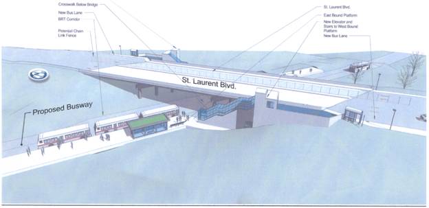
Section 1 - St. Laurent Blvd. and Former Railway Corridor (Figure 4) - This grade-separated transit station is to be retrofitted at the existing bridge and will include elevator and stair connections between levels. An at-grade pedestrian crossing will be allowed at Transitway level due to lower transit volumes and space limitations between the existing bridge piers. This station serves as a transfer point between intersecting north-south and east-west transit services.
Figure 4 - St. Laurent Blvd. / Rail Corridor Station
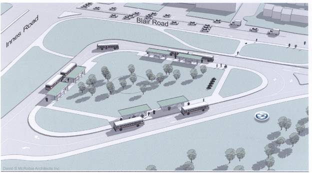
Section 3 - Innes Road at Blair Road (Figure 5) - An at-grade station at this location will accommodate transfer activity between the Cumberland Transitway Westerly and the Hospital Link transit corridor as well the trips to-from the residential community to the west and commercial properties along Innes Road west of Blair Road. All four quadrants of the Innes Road - Blair Road intersection were considered for this station; however, the quadrants other than the northeast are all developed and are not easily accessed from the recommended Cumberland Transitway Westerly alignment.
Figure 5 - Innes Road - Blair Road Station
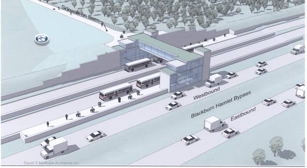
Section 4 - Blackburn Hamlet Bypass - West Station (Figure 6) - This typical Transitway station layout will include both an at-grade pathway connection and a vehicle ‘Kiss-and-Ride’ drop-off with a turn around. A pedestrian overpass structure to access the far side platforms will be aligned with the town centre of Blackburn Hamlet to the north which also avoids the more sensitive natural areas to the west.
Figure 6 - Blackburn Hamlet Bypass - West Station

Section 4 - Blackburn Hamlet Bypass - East Station (Figure 7) - Station access from the community will be via a pedestrian pathway, to be designed to ramp up and over the existing berm along the north edge of the Bypass. A pedestrian overpass structure to access far side platforms will be provided.
Figure 7 - Blackburn Hamlet Bypass - East Station
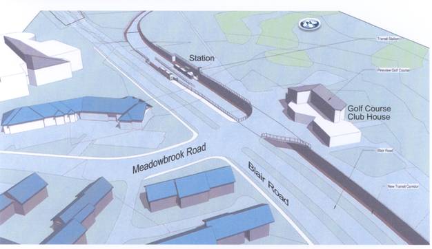
Section 5 - Blair Road - Meadowbrook Station (Figure 8) - This station will serve the significant employment node to the west and the northern portion of the Pineview community. A grade‑separated access to the Pineview Golf Course will also enable pedestrian crossing of the Transitway.
Figure 8 - Blair Road - Meadowbrook Station
· The remainder of the transit stops will be curb side bus stops identified with signage and/or bus shelter design as being part of the City’s rapid transit system. Bus stops will be provided on: the Alta Vista Transportation Corridor - Hospital Spur (2 to 3 between the Southeast Transitway and the General Hospital Ring Road access); Terminal Avenue - Trainyards Drive - Belfast Road (4); and, Innes Road (4 between Bantree Street and Stonehenge Crescent (East)).
Property Requirements
Lands in both the private and public domain are required. Portions of 73 properties are needed for this project with an approximate total land area of 24.4 hectares including.
· 2.2 hectares already owned by the City of Ottawa;
· 20.8 hectares from the NCC;
· 0.4 hectares from other public agencies or crown corporations including small parcels from Public Works and Government Services Canada, the MTO, VIA Rail, Canada Post and Hydro One; and
· 1.0 hectares from private owners.
Acquiring the required property in a timely manner allows for the proper sequencing of construction staging, which minimizes disruption to traffic. This is particularly important for lands associated with Sections 3, 4 and 5 of project which are scheduled for short term implementation.
Natural Environmental and Archaeological Effects
The study area varies greatly from a highly urbanized area in the west to a more rural natural area in the east. As a result, the potential impact to the natural environment, including fisheries and terrestrial, is greatest in the east end of the study area through Sections 3, 4 and 5 which are adjacent to the NCC’s Greenbelt lands. There is also the greatest need for property within these sections and the greatest potential for archaeological resources due to the amount of undeveloped land. Further archaeological assessment (i.e. Stage 2 test pitting) should be undertaken in subsequent design phases.
Heritage and Culture
A property with heritage potential is located in Section 3 near the intersection of Blair and Innes Roads. It is a rented dwelling (1691 Blair Road) located on NCC Greenbelt property which will be directly affected by a proposed Transitway station. The brick farmhouse dates to the early twentieth century and is listed by the City as having potential heritage value. It is not designated under the Ontario Heritage Act. Consultation will be required with the NCC to determine appropriate mitigation. Relocation to another Greenbelt site has been discussed with the NCC and may in fact allow a more appropriate setting for the building than currently exists.
There are no cultural landscapes affected.
Noise and Vibration
The recommended plan is generally anticipated to have an insignificant impact on air quality and noise levels for sensitive receivers. In two residential areas where existing and future noise levels exceed 60 dBA, noise attenuation barriers are recommended in accordance with the City's noise policy as follows:
· 360 m of 2.5 m high noise barrier along the west side of Blair Road from Beaverpond Drive south towards Innes Road, and
· 230 m of 3.0 m high noise barrier (or berm) along the north side of the Transitway for homes along Pepin Court.
Ground vibrations are currently low and impacts from the proposed plan are not significant.
Pedestrian and Cycling
There will be improvements to pedestrian and cycling facilities with the addition of sidewalks and cycling lanes throughout the project. There is also the potential for better access to commercial properties within Section 1, in particular around Terminal Avenue and the Trainyards.
Utilities
Impacts to utilities, such as hydro, street lighting, traffic signals and gas mains, are the most significant in Sections 2, 3 and 4 where relocation will be required.
Stormwater Management
For stormwater management, the recommended plan will see a moderate increase overall in impervious surfaces. Mitigation measures to improve stormwater management for both quantity and quality are recommended for the different sections of the project and reflect the opportunities and constraints within each section (i.e. urban vs. rural roadway cross-sections). A new stormwater management facility is proposed to be integrated with the Pineview Golf Course as a water feature/irrigation source. It is proposed that the recently constructed stormwater management pond for the OC Transpo maintenance facility at 735 Industrial Avenue be expanded to accommodate stormwater runoff from the busway. Linear flat bottom ditch systems are proposed along the Blackburn Hamlet Bypass. Oil and grit separators and on-line retention as part of modified existing storm sewers are also recommended for widened roadway sections.
The City is currently conducting a comprehensive stormwater management strategy and identifying opportunities for stormwater retrofit. In subsequent design phases the results of this strategy will be reviewed and mitigation measures revised as appropriate.
Geotechnical
The area west of Highway 417 is generally underlain by glacial till overlying shallow bedrock. The area east of Highway 417 is generally underlain by thick deposits of silty clay of up to 50 m in depth that are more compressible and therefore more vulnerable to overstressing and settlement from structure foundations and roadway embankments.
Vertical alignments are to be kept as close as possible to existing grades within the eastern portion of this study area. Bridge structures and permanent vertical retaining walls will need to be supported on very deep foundations (i.e. piles) on the underlying bedrock. Lightweight fill may be required for larger embankments over clay such as at the Mud Creek crossing widening and at the berm north of the proposed Blackburn Hamlet Bypass - Eastern Transit Station.
Potential groundwater lowering is a concern at the Transitway underpass where Innes Road enters Blackburn Hamlet and at the Meadowbrook Station / Pineview Golf Course entrance - which may require that structures be watertight and anchored to resist the buoyant forces. The potential impact of groundwater level lowering on any nearby wells (i.e. at the golf course) and possible long term consolidation settlement of the clay deposit located to the east of the Transitway at this location will be addressed during detail design.
Basal instability is of concern at the Transitway underpass where Innes Road enters Blackburn Hamlet both during construction and for the in-service condition which may influence construction methods and the final design.
The preliminary geotechnical assessment and recommendations are currently at a functional planning level at this time based on a preliminary study of available information on subsurface conditions. Additional field investigations will be required during detail design to verify subsurface conditions. Based on this potential risk, a high contingency allocation is captured in the project cost estimate.
Extensive public and agency stakeholder consultation has taken place to date including two public open houses; a transit corridor alternatives evaluation workshop; Agency, Public and Institutional Consultation Group meetings; and, various invidual stakeholder group meetings. Information from the study has been posted on the City’s web site:
http: /www.ottawa.ca/residents/public_consult/hospital_cumberland/index_en.html.
In addition to the Consultation Group meetings (four meetings each including presentation of the recommended plan), formal Public Open Houses (POH) and presentation were conducted on 29 April 2009 and 23 June 2009. Individual meetings were also arranged with the MTO, Hydro Ottawa and the NCC, as well as the Board of Directors of the Pineview Golf Club.
Contact letters have been sent to the Ontario Ministry of Aboriginal Affairs, Indian and Northern Affairs Canada (INAC), and, the Algonquins of Ontario Consultation Office. The Algonquins of Ontario have expressed an interest in the project and have advised that the proposed undertaking is located within the Algonquin Land Claim area which is currently the subject of negotiations between the Government of Canada, the Province of Ontario and the Algonquins of Ontario. Further notifications will take place as part of the formal EA process.
Public Open Houses (POH)
A Public Open House was held on two separate occasions:
Public Open House #1 (29 April 2009)
The POH was arranged to present the study process, objectives, background, and schedule, and to provide the public an opportunity to discuss the study with the project team. Approximately 85 people attended. A total of 36 comment sheets were received.
Public Open House #2 (23 June 2009)
The POH was arranged to present an update on the study progress and to provide the evaluation of Alternative Design Concepts, as well as provide the public an opportunity to discuss the project with the project team. Approximately 85 people attended. A total of 33 comment sheets were received.
The recommended plan was presented to the Consultation groups on 23 April 2010 (ACG) and 28 April 2010 (PCG).
Issues Arising From Consultation
The major issues arising from consultation are as follows:
National Capital Commission - Greenbelt and Federal Lands
The recommended alignment for the Hospital Link and Cumberland Transitway Westerly affects several federal land holdings including lands at Hurdman Station; Greenbelt lands adjacent to Blair Road, Innes Road and south of the Blackburn Hamlet Bypass; as well as lands designated Surplus to the Greenbelt north of the Blackburn Hamlet Bypass.
The following are issues that the NCC had raised, and are reflected in the recommended plan:
· Avoidance of Greens Creek - Busway alignment is located on existing west bound lanes of Innes Road with Innes Road shifted to the south to avoid north side lands at Greens Creek designated as “Core Natural Area” in the 1996 Greenbelt Master Plan. Selected alignment of busway at Greens Creek crossing avoids extension of Greens Creek bridge structure at either end and therefore avoids Creek encroachment.
· Minimization of Project Footprint through Greenbelt– The combined Transitway and realigned Innes Road cross-section between Blair Road and the Blackburn Hamlet Bypass has been reduced to the minimum reasonable width to limit footprint effects and encroachment on NCC lands. Further, the future Innes - Walkley Connection at Innes Road is proposed as a full intersection including a westbound double left-turn lane, rather than with a grade-separated westbound ramp (as envisioned in the long term) to avoid an encroachment on NCC Greenbelt lands to the north.
· Maintain Rural Shoulders - Rural edges (i.e. paved shoulders) are proposed along the east side of the Transitway along Blair Road and along both sides of the Transitway along the Blackburn Hamlet Bypass.
· Limit Stations Within Greenbelt - The number of transit stations initially considered within the Greenbelt area has been reduced from six to four. Two stations along the Blackburn Hamlet Bypass will be adequate to maintain good access to transit - particularly with the addition of a Kiss-and-Ride drop-off at the westerly station. The station at the west limit of the Bypass and Innes Road has been replaced with a transitway access ramp off of Pepin Court for local service through Blackburn Hamlet thus avoiding the need for transfers at this location.
Other issues raised by the NCC are as follows:
· Natural Features / Ecosystems / Property No Net Loss - NCC has stated that the integrity of valued natural features and ecosystem components must be protected in the Greens Creek valley and that, at a minimum, a “no net loss” approach to natural features and property transactions (in terms of both quantity and quality) is required.
· Greens Creek Watershed Fluvial Geomorphologic Risk Assessment - NCC indicated that options can only be considered within the area identified as at risk in the Greens Creek Watershed Fluvial Geomorphologic Risk Assessment in absence of other feasible alternatives. Any options accepted in the area at risk must be accompanied by a comprehensive multidisciplinary analysis of downstream and upstream effects as well as potential measures to mitigate and enhance the entire environment. Options in the area at risk must fully indemnify the NCC against future risk. Improvements to deficiencies of existing infrastructure are required in keeping with the recommendations of the Greens Creek Watershed’s Fluvial Geomorphology Study.
· Transit Stations - The NCC has noted that justification is required for the proposed transit stations in the Greenbelt. A pedestrian pathway and habitat conservation plan is required for all stations proposed along Blackburn Hamlet By-pass.
· Pineview Golf Course - The NCC has stated that an area plan, i.e. a site master plan, is required for the Pineview Golf Course if property is needed along Blair Road. The area plan must include a comprehensive approach to ecology, landscape architecture and aesthetics, stormwater management, and soil stability to minimize fluvial geomorphologic risks.
· NCC Greenbelt Master Plan - A ‘Joint Comprehensive Study of Transportation Projects within the Greenbelt’ to assess sensitivity and cumulative impacts of transportation infrastructure on Greenbelt lands is yet to get underway but is currently being discussed with the City. The NCC advised that if the provincial EA is finalized before this study is complete, amendments to the EA may be required in the future.
· NCC Urban Lands Master Plan - NCC has advised that the proposed alignment would require integration into the NCC’s Urban Lands Master Plan process for the section along the Blackburn Hamlet Bypass.
· Context-Sensitive Design - NCC has stated that a context-sensitive design approach to Transitway infrastructure must be used in the Greenbelt. Design guidelines for the Transitway infrastructure in the Greenbelt must be completed, based on a context sensitive approach.
The Environmental Project Report (EPR) will document the above issues. Several of these issues can only be addressed at the detail design of the project. Further environmental analysis may be required during detailed design once the NCC’s Greens Creek Watershed’s Fluvial Geomorphology Study has been finalized, and the associated Risk Area Mapping made available to the City.
Ministry of Transportation Ontario - Highway 417
The recommended transit corridor crosses Highway 417 at Innes Road. The MTO’s concerns relate to the impact of the bus facility on the operation of the highway:
· The operational and physical effects of road widening on the bridge and ramps.
· Should the bridge ultimately require replacement, the timing and staging of this work.
· The potential for queuing problems on the ramps.
· The impact on weaving to and from ramps on Innes Road.
Although it was initially considered, the recommended plan for 2031 no longer calls for widening - replacement of the bridge at Highway 417. Potential weaving concerns have been assessed and solutions proposed. If implementation occurs beyond 10 years from the date of this study, the City will review all relevant traffic analysis at that time.
Riverview Park Community Association - Browning Corridor
The Riverview Park Community Association (RPCA) is opposed the use of the Browning Avenue Corridor as a transit route. Key issues of concern were the potential impacts to residential communities north of the proposed alignment; the potential impacts to hospital facilities (in particular to the Perley and Rideau Veterans’ Health Centre); the removal of green space (and, as a result, a pedestrian facility); implications of hydro relocations; and, the potential for increase in noise, ground vibrations, and air pollution.
Following the Alternatives Evaluation Workshop, the Browning Avenue corridor option was no longer considered for further analysis as it related poorly in comparison to other options due to high cost of hydro tower relocates, and greater potential social-environmental impact to the local community. This was presented and approved by Transit Committee and Council in October 2009.
Blackburn Hamlet Community Association - Community Impacts
The Blackburn Hamlet Community Association (BHCA) was strongly opposed to a Transitway alignment through Blackburn Hamlet via Innes Road or along the southern edge of Blackburn Hamlet. Concern was also expressed regarding impact to the existing community gardens (located north of the Blackburn Hamlet Bypass).
Following the Alternatives Evaluation Workshop, the Blackburn Hamlet Bypass corridor was chosen as the preferred Transitway alignment as it lessened the direct impact to the community while still providing good accessibility to transit.
The Ottawa Trainyards - Impacts to Land Development
A representative of the Ottawa Trainyards land development project has been actively involved in the study, serving as a member of the Public Consultation Group. The Ottawa Trainyards own portions of the former railway corridor that had been considered as a possible alignment as well as lands along Terminal Avenue. As the recommended plan is now along Belfast Road, the greatest potential impact to the Trainyards lands has been avoided signifying that only strips of land are still required from this landowner along Terminal Avenue.
Pineview Golf Course - Operations and Aesthetics
The section of the Transitway along Blair Road will have impacts on the Pineview Golf Course including: site access, site circulation, parking, increased noise levels, potential vibration and air quality concerns and aesthetics. Three meetings to date have been conducted with the General Manager of the golf course (some of which included full or partial additional representation from the Board of Directors).
Elements of the recommended plan which respond to the concerns at the Golf Course include: new signalized access to the golf course; grade-separation and lowering of Transitway profile (reduces noise levels and shields the Transitway as viewed from the club house); relocation of parking; and new-replacement landscaping.
Hospital Lands Stakeholders
Various stakeholder groups representing hospital institutions and other land owners actively participated in the study through the Institutional Consultation Group (ICG). Interests of these stakeholders were varied but generally included the following:
· Maintenance of vehicular access to the lands and avoidance of impacts to existing parking facilities or future development lands.
· Integration of transit within the hospital lands area and maintaining a good level of service transit for employees and visitors including good pedestrian access to transit.
The recommendations of the approved Alta Vista Transportation Corridor EA study are considered to have addressed these concerns.
Impacts to Local Businesses
Various modifications to the recommended design have been made to limit impacts to local businesses. Consultation with project stakeholders, including business interests - landowners, are ongoing as part of the study.
COMMENTS BY THE WARD COUNCILLOR(S)
Councillor Bloess, Councillor Bellemare and Councillor Hume are aware of this report.
LEGAL/RISK MANAGEMENT IMPLICATIONS
There are no legal/risk management impediments to implementing this report's recommendations.
CITY STRATEGIC PLAN
The recommendation contained herein aims to support the following Strategic Directions adopted by Council on 11 July 2007:
A1 Improve the City's transportation network to afford ease of mobility, keep pace with growth, reduce congestion and work towards model split targets.
B1 Attain transit goals (30 per cent modal split) by 2021.
E6 Require walking, transit and cycling oriented communities and employment centres.
F4 Ensure that City infrastructure required for new growth is built or improved as needed to serve the growth.
TECHNICAL IMPLICATIONS
N/A
FINANCIAL IMPLICATIONS
The preliminary project cost estimate to design and construct the Hospital Link and Cumberland Transitway Westerly is approximately $340.0 M in 2010 dollars, unescalated.
The following provides a cost breakdown in 2010 dollars:
·
Construction – Hurdman Station to Blair Station and Cumberland
Transitway Westerly
(13km)
$210 M
· Design, Project Management, Construction Administration (30%) $ 62 M
· Property Acquisition $ 15 M
· Project Contingency (20%) $ 53 M
$340 M
Cost estimates will form part of the Long-Range Financial Plan, which will be tabled later this year. Funds will be requested, at the appropriate times, through the capital budget process.
Funding for the environmental assessment process is provided for in Capital Account 902135 (Rapid Transit EA Studies).
SUPPORTING DOCUMENTATION
Document 1 Hospital Link and Cumberland Transitway Westerly Functional Design Plans (July 2010)
DISPOSITION
Following Committee and Council approval of the functional design, the Planning and Growth Management Department will undertake the following:
· Initiate and complete the formal EA process using the functional design to define the undertaking and file the EA Report with the Ministry of the Environment in accordance with Ontario EA Regulation 231/08 for transit project.
· Initiate the property acquisition process as appropriate, subject to the completion of the EA process and subsequent year capital funding requests.