|
|
Committee recommendation
(This
matter is not Subject to Bill 51)
That Council
approve an amendment to Zoning By-law 2008-250 to change the zoning of 940 Old
Montréal Road from Development Reserve (DR) to Residential Third Density,
Subzone VV (R3VV), Residential Fifth Density, Subzone A (R5A), Residential
Fifth Density, Subzone A, Maximum Height 16 metres, (R5A H(16)), Environmental
Protection (EP), Environmental Protection 1 (EP1), and Parks and Open Space O1
as shown in Document 1 and as detailed in Document 2.
RECOMMANDATION DU
COMITÉ
(Cette
question n’est pas assujettie au Règlement 51)
Que le Conseil approuve
une modification
au Règlement de zonage 2008-250 afin de changer la désignation de zonage du
940, chemin Old Montréal de Zone d’aménagement futur (DR) à Zone résidentielle
de densité 3, sous-zone VV (R3VV), Zone résidentielle de densité 5, sous-zone A
(R5A), Zone résidentielle de densité 5, sous-zone A, assortie d’une hauteur
maximale de 16 mètres (R5A H(16)), Zone de protection de l’environnement (EP),
Zone de protection de l’environnement 1 (EP1) et à Zone de parc et d’espace
vert (O1), comme il est indiqué dans le Document 1 et décrit en détail dans le
Document 2.
Documentation
1. Deputy City Manager's report Infrastructure Services and Community
Sustainability dated 1 September 2010 (ACS2010-ICS-PGM-0171).
2. Extract of Draft Minutes of 14
September 2010.
Report to/Rapport au :
Planning
and Environment Committee
Comité de l'urbanisme et de l'environnement
01 September 2010 / le 01 septembre
2010
Submitted by/Soumis
par : Nancy Schepers, Deputy City Manager/Directrice
municipale adjointe, Infrastructure
Services and Community Sustainability/Services d’infrastructure et Viabilité
des collectivités
Contact
Person/Personne-ressource : Derrick Moodie, Acting Manager/Gestionnaire,
Development Review-Suburban Services/Examen des projets d'aménagement-Services
suburbains, Planning and Growth Management/Urbanisme et Gestion de la
croissance
(613) 580-2424, 15134 Derrick.Moodie@ottawa.ca
|
SUBJECT: |
|
|
|
|
|
OBJET : |
REPORT RECOMMENDATION
That Planning and Environment
Committee recommend Council approve an amendment to Zoning By-law 2008-250 to
change the zoning of 940 Old Montreal Road from Development Reserve (DR) to
Residential Third Density, Subzone VV (R3VV), Residential Fifth Density,
Subzone A (R5A), Residential Fifth Density, Subzone A, Maximum Height 16
metres, (R5A H(16)), Environmental Protection (EP), Environmental Protection 1
(EP1), and Parks and Open Space O1 as shown in Document 1 and as detailed in
Document 2.
RECOMMANDATION DU RAPPORT
Que le Comité de l’urbanisme
et de l’environnement recommande au Conseil d’approuver une modification au Règlement de
zonage 2008-250 afin de changer la désignation de zonage du 940, chemin Old
Montréal de Zone d’aménagement futur (DR) à Zone résidentielle de densité 3,
sous-zone VV (R3VV), Zone résidentielle de densité 5, sous-zone A (R5A), Zone
résidentielle de densité 5, sous-zone A, assortie d’une hauteur maximale de 16
mètres (R5A H(16)), Zone de protection de l’environnement (EP), Zone de
protection de l’environnement 1 (EP1) et à Zone de parc et d’espace vert (O1),
comme il est indiqué dans le Document 1 et décrit en détail dans le Document 2.
BACKGROUND
The subject property is bounded to the north by
Old Montreal Road, to the east by low density residential development fronting along
Gerald Street, to the south by Watters Road and to the west by Trim Road.
The subject land is characterized as an open meadow, gently rising from Old Montreal Road to Watters Road. Two significant woodlots are located adjacent to Old Montreal Road and Watters Road. The site contains an area of 11.4 hectares with approximately 172 metres of frontage along Old Montreal Road, 455 metres along Trim Road and 95.5 metres along Watters Road. Primary access to the site will be provided from Old Montreal Road with a right-in/right-out access on Trim Road. No access will be provided to Watters Road. A number of local roads are to be created to provide access to individual lots.
Purpose of Zoning Amendment
The applicants are proposing to amend the Zoning By-law to implement residential zones which will permit detached, multiple attached dwellings and mid-high rise apartment dwellings. The new zoning would conform to the lot and road pattern outlined in the Draft Plan of Subdivision approved by the City on December 23, 2008.
The proposal consists of 39 lots for detached dwellings and seven blocks for 73 multiple attached dwellings. The plan also proposes two blocks for residential buildings up to a mid-high rise apartment dwelling. The subdivision also includes lands to be dedicated to the City for the open space, environmental protection lands, a walkway and streets.
The Zoning By-law zones the lands DR (Development Reserve), which recognizes lands intended for future urban development in areas designated as General Urban Area.
The purpose of the Zoning By-law amendment is to permit the construction of detached dwellings, multiple attached dwellings and mid-high rise apartment dwellings in accordance with the Draft Plan of Subdivision.
DISCUSSION
The Official Plan designates the site as General Urban Area with a portion located in the south east corner as Urban Natural Feature. The General Urban Area designation permits a full range of types and densities of housing to meet the needs of all ages, incomes and life circumstances, including low, medium and high density housing and seniors’ apartments, in combination with well located employment, shopping, service, cultural, leisure, park, natural areas and institutional uses to facilitate the development of complete and sustainable communities. The Urban Natural Feature designation is to preserve natural features that are currently managed for conservation or passive leisure uses.
The Development Reserve Zone of the Zoning By-law recognizes that the subject lands are intended for future development. The proposed subdivision is one of the few remaining undeveloped areas within this vicinity, with the Urban Boundary located approximately 550 metres to the east.
The street layout services the proposed development and a proposed walkway block has been reserved to provide a pedestrian connection between the proposed development and the established subdivision to the east.
The proposed zoning for this
subdivision is consistent with the approved draft plan of subdivision. The
zoning makes use of the existing Residential Third Density and Residential
Fifth Density zones within the Zoning By-law, indicating that the general form
of development has been previously contemplated and is considered appropriate.
The lands to be conveyed from the Owner to the
City through the subdivision agreement for parks purposes will be zoned Parks
and Open Space, (O1). The Urban Natural Feature lands to be conveyed to the
City will be zoned Environmental Protection (EP).
ENVIRONMENTAL IMPLICATIONS
The two significant woodlots which are presently on the site will be under the ownership of the City. The northern portion, abutting Old Montreal Road will be dedicated as parkland and the southern portion, part of Urban Natural Feature No. 94, abutting Watters Road, will be acquired by the City.
A condition has been included in the draft conditions requiring that new plant materials are to consist only of species native to Eastern Ontario and reflect the natural landscape.
RURAL IMPLICATIONS
N/A
CONSULTATION
Notice of this application was carried out in accordance with the City's Public Notification and Consultation Policy. The City received public comments related to the concurrent draft plan of subdivision and zone amendment applications. A summary of comments is presented in Document 3.
COMMENTS BY THE WARD COUNCILLOR(S)
Councillor Bob Monette - Orléans indicated during a
meeting with staff that he was concerned with the potential impact that the
increased traffic would have on the existing road network and traffic circulation, and
identified the issue as the community’s primary concern.
Councillor Monette also indicated concern with the
potential impact that the construction activity could have on the foundations
and wells of the nearby Gerald Street residential properties and, as such, requested that
measures to mitigate such impact be implemented. Also, he expressed that only large lots
intended for single detached dwellings should abut the Gerald Street properties
along the eastern boundary of the subdivision as a means to respect the privacy of existing
residents as much as possible.
Councillor Monette supports the preservation
and protection of the existing forested areas at the north and south extremes
of the site through either parkland dedication or acquisition by the City, or
both. He also indicated that sidewalks
should be provided throughout the subdivision and along Trim Road to allow for
the efficient and safe movement of pedestrians, and expressed support in
principle for the future pedestrian pathway connection between the proposed
development and Gerald Street. Finally,
the Councillor indicated that he did not support the proposed retirement
residence within the subdivision, as, in his opinion, there are already more
than enough similar proposed or approved residences in Orléans.
Document 3 contains the staff response to the
Councillor’s comments.
LEGAL/RISK MANAGEMENT IMPLICATIONS
There are no legal/risk management implications associated with this report.
CITY STRATEGIC PLAN
In accordance with the City Strategic Plan, this development respects the existing urban fabric and the infrastructure required for the growth is available or will be available to serve the development.
TECHNICAL IMPLICATIONS
FINANCIAL IMPLICATIONS
There are no direct financial implications associated with this report.
APPLICATION PROCESS TIMELINE STATUS
The application was not processed by the "On Time Decision Date" established for the processing of Zoning By-law amendments due to the concurrent review of the subdivision application.
SUPPORTING DOCUMENTATION
Document 1 Location Map
Document 2 Details of Recommended Zoning
Document 3 Consultation Details
DISPOSITION
City Clerk and Solicitor Department, Legislative Services to notify the owner/applicant, OttawaScene.com, 174 Colonnade Road, Unit #33, Ottawa, ON K2E 7J5, Ghislain Lamarche, Program Manager, Assessment, Financial Services Branch (Mail Code: 26-76) of City Council’s decision.
Planning and Growth Management Department to prepare the implementing by-law, forward to Legal Services Branch and undertake the statutory notification.
Legal Services Branch to forward the implementing by-laws to City Council.
LOCATION MAP DOCUMENT 1
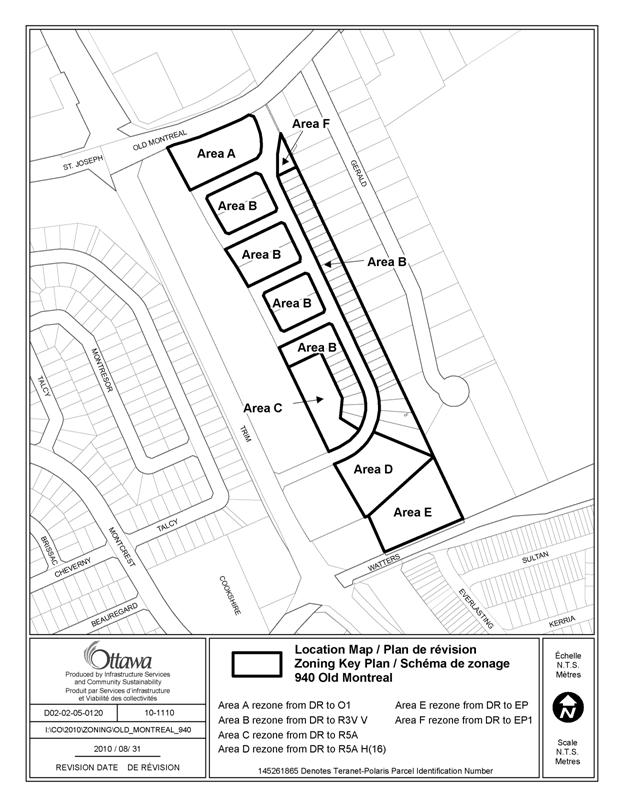
DETAILS OF RECOMMENDED ZONING DOCUMENT 2
A. Zoning By-law 2008-250
The zoning map of the Comprehensive City of Ottawa Zoning By-law will be amended by changing the zoning for the subject properties from Development Reserve (DR) to R3VV, R5A, R5A H(16), EP, EP1 and O1as shown on Document 1.
CONSULTATION DETAILS DOCUMENT 3
NOTIFICATION AND CONSULTATION PROCESS
Notification and public consultation was undertaken in accordance with the Public Notification and Public Consultation Policy approved by City Council for Zoning By-law amendments. Three public meetings were also held in the community in association with both the draft plan of subdivision and the Zoning By-law amendment.
Enhanced notification was carried out and included the holding of three public meetings in the community – the first held on 18 April 2006 to consider the initial application submission, the second held on 6 September 2007 to consider the substantially revised resubmission, and the third held on 30 September 2008 to present the final plan to the public. Public notices of the first two meetings were sent by mail to all property owners within 120 metres of the proposed development site, and also were provided in the local English and French language community newspapers. On-site notices of both meetings were also provided. Councillor Monette presided over both meetings, each of which was attended by approximately 40 members of the public. Public notice of the final meeting was mailed to surrounding residents by the Councillor’s office. Approximately 20 members of the public attended this meeting.
PUBLIC COMMENTS
The most common concern expressed was the
expected further increase in traffic congestion in the vicinity of the
development and particularly along Trim Road.
Also, many concerns were expressed about the blind and potentially
dangerous intersection at Old Montreal Road and the local street of the
proposed subdivision. An equal number of
concerns were expressed over the perceived high density of development, at 180
dwelling units not including the retirement home. Residents were concerned that such a density
would change the character of the area.
Specific to Gerald Street residents, a common
concern was expressed about the potential impact that the proposed development
and ensuing construction activity could have on the integrity of their wells
and foundation walls. The residents
requested that appropriate measures and safeguards be implemented to prevent
damage to such structures. Also, with
such a high-density development proposed next to their properties, the
residents anticipate a significant loss of privacy and enjoyment of their
respective properties. It was urged that
appropriate forms of screening be required to mitigate such losses as much as
possible.
Finally, similar concerns as those outlined by
the Ward Councillor were expressed generally about pedestrian connectivity and
the provision of sidewalks, the preservation of both wooded areas, and the
preference for low-density single detached dwellings abutting the Gerald Street
properties.
Generally, the majority of public that provided
comment understood that development of the subject site was inevitable, but
they clearly expressed that such development should be compatible with the
surrounding residential character and simply be of a high quality.
Response to Comments
The proposed draft plan of subdivision was further revised largely in direct response to the concerns expressed by the public over the previous proposed subdivision layout and composition.
With respect to the concerns expressed over increased traffic and circulation, the main public street through the subdivision is now proposed to intersect Old Montreal Road and Trim Road, which should somewhat reduce the volume of traffic that was projected to enter or exit the subdivision solely through the intersection at Old Montreal Road. However, the construction of the intersection at Trim Road will be restricted to right-in/right-out movements only. The revised traffic study submitted in support of the application and reviewed by City staff confirms that the existing road network in the vicinity of the proposed subdivision is adequate to handle the projected increase in traffic.
The proposed number of dwelling units has decreased from 180 to 166 units, not including the
retirement residence. This represents a
development density of about 44 dwelling units per net hectare. Planning staff are satisfied that such
density is consistent with the relevant policies of the Official Plan, and that it should not
adversely affect the low-density residential character of the surrounding
neighbourhoods.
It should be noted that several of the recommended conditions of draft
plan of subdivision approval address matters of urban design in an effort to ensure that the
proposed development is of the highest quality.
While the site’s topography presents a considerable constraint to
development, it also affords opportunities to create dramatic streetscapes with
a varied mix of
dwelling types.
Response to Councillor Comments
As noted above, following the second public
meeting, the proposed draft plan of subdivision was further revised to respond
to the Councillor’s and public concerns.
The most notable change was to the road pattern. The main north-south local street through the
subdivision now connects to Trim Road as well as to Old Montreal Road. This modification to the street layout will redistribute
traffic circulation in the vicinity of the subject development. However, it is noted that such connection to
Trim Road will be restricted to right-in/right-out turning movements.
The revised draft plan also delimits the urban
natural forest at the south limit of the site as a block on the draft plan. Staff’s
conditions of approval recommend that the City commence the acquisition of the
block for protection and Council has already approved the acquisition and
budgeted for it accordingly. Measures to
acquire the block have already been initiated.
Similarly, the forested area at the north limit of the subject lands is
to be conveyed to the City as parkland dedication largely in an effort to
preserve the existing forest cover. With
respect to the protection of privacy for the existing Gerald Street residents,
the draft plan proposes only large single detached lots (11.4 metres in width)
along the entire east limit of the subdivision.
While the draft plan continues to reserve a
block for a retirement home use, it should be noted that the same block is
sufficiently sized to accommodate apartment dwellings should the retirement
home proposal not be realized. The
proposed zoning of this block will permit either use.
The remaining concerns of the Councillor
respecting the integrity of Gerald Street residential foundations and wells,
and the provision of sidewalks, are adequately addressed in the conditions of
draft plan of subdivision. Sidewalks are to be located on the west/north side
of Antigonish Avenue, the road connecting Old Montreal Road to Trim Road. Further,
the widening of Trim Road is currently in the design stage and will include
sidewalks on both sides of the road. There is a requirement for a
preconstruction survey for the residential properties on Gerald Street and the
single dwelling on Trim Road immediately adjacent to the subdivision. This has
been provided to the City. A well interference report was also required through
the draft conditions and has been completed, indicating no concerns.