|
COMMITTEE RECOMMENDATION
(This
application is subject to the provisions of Bill 51.)
That Council approve amendments to the
Zoning By-law, 2008-250 to change the zoning of 7510, 7527, 7550, 7564, 7574,
7577, 7586, 7601, 7606 Village Centre Place and 1438 Water’s Edge Way (Blocks
61, 62, 63, 64, 65, 66, 69, 70, 73, 74 PLAN 4M-1398) as shown in Document 1 and
as detailed in Document 2.
RECOMMANDATION DU
COMITÉ
(Cette application est
assujettie aux dispositions du Règlement 51.)
Que le Conseil municipal approuve
les modifications au Règlement de zonage no 2008-250 en vue de
changer le zonage des propriétés situées aux 7510, 7527, 7550,
7564, 7574, 7577, 7586, 7601 et 7606, place Village Centre, et au 1438, voie
Water’s Edge (Îlots 61, 62, 63, 64, 65, 66, 69, 70, 73 et 74, PLAN 4M-1398),
comme le montre le document 1 et l’explique le document 2.
Documentation
1. Deputy City Manager’s Report, Infrastructure
Services and Community Sustainability dated 8 November 2010
(ACS2010-ICS-PGM-0210).
Report to/Rapport au :
Agriculture and Rural Affairs Committee
Comité
d'agriculture et des affaires rurales
and Council / et au Conseil
08 November 2010 / le 08 november 2010
Submitted by/Soumis par :
Nancy Schepers, Deputy City Manager/Directrice
municipale adjointe, Infrastructure Services
and Community Sustainability/Services d’infrastructure et Viabilité des
collectivités
Contact
Person/Personne-ressource : Derrick Moodie, Manager/Gestionnaire, Development
Review-Rural Services/Examen des projets d'aménagement-Services ruraux,
Planning and Growth Management/Urbanisme et Gestion de la croissance
(613)
580-2424, 15134 Derrick.Moodie@ottawa.ca
REPORT RECOMMENDATION
That the Agriculture and Rural Affairs Committee recommend City Council
approve amendments to the Zoning By-law, 2008-250 to change the zoning of 7510,
7527, 7550, 7564, 7574, 7577, 7586, 7601, 7606 Village Centre Place and 1438
Water’s Edge Way (Blocks 61, 62, 63, 64, 65, 66, 69, 70, 73, 74 PLAN 4M-1398)
as shown in Document 1 and as detailed in Document 2.
RECOMMANDATION
DU RAPPORT
Que le Comité de l’agriculture et des affaires rurales recommande au Conseil municipal
d’approuver les modifications au Règlement de zonage no 2008-250
en vue de changer le zonage des propriétés situées aux 7510, 7527, 7550, 7564, 7574, 7577, 7586, 7601 et 7606, place Village
Centre, et au 1438, voie Water’s Edge (Îlots 61, 62, 63, 64, 65, 66, 69, 70, 73
et 74, PLAN 4M-1398), comme le montre le document 1 et l’explique le document
2.
BACKGROUND
The subject areas to be rezoned are located within the Greely’s Village Commercial Centre, more specifically along Water’s Edge Way and Village Centre Place.
Purpose of the amendment
This amendment is a City initiated rezoning intended for two reasons:
- To remove the all residential uses from the list of permitted uses of the Village Mixed Use zoning which allows for development on systems providing for full treatment and monitoring (communal sewage systems); and
- To rezone two Blocks from a Village Mixed Use zoning to a Single Family Residential zoning which would allow for development on private on-site individual services.
Proposed Zoning (see Document 2)
Area A:
Rezone from:
VM3[324r]-h - Village Mixed Use Subzone 3 with Exception and
holding.
To:
V1E[617r] - Village
Residential First Density Subzone E with Exception.
Area B and C:
Add the use “Dwelling Unit” to the “Land Uses Prohibited” list of
Exception [317r] and delete the provision stating “maximum of 2 dwelling units
per commercial use located in the upper storeys above any commercial use” from
the “Provisions” list of Exception [317r].
Area D and E:
Rezone from:
VM3 H(10.7) - Village Mixed Use Subzone 3 with Maximum Building
Height of 10.7 metres.
To:
VM3[XXXr] H(10.7) - Village Mixed Use Subzone 3with Exception and
with Maximum Building Height of 10.7 metres.
DISCUSSION
The current zoning for the development within Greely Village Centre subdivision permits development on lots provided:
(a)
with traditional septic fields; and
(b)
as well as a number of lots where sanitary sewage
treatment is to be provided with a wastewater treatment system that will
achieve a nitrate impact no greater than 2.5 mg/l or such other limit
established by the Ministry.
The provision in (b) was agreed to by the City and the developer in order to ensure that the overall nitrate impact of the development was within the guidelines issued by the Ministry of the Environment.
Certain of the lots made subject to (b) above contained permission for residential uses. The developer anticipates achieving the 2.5 mg/l criterion through the use of a communal wastewater treatment system. In the case of residential uses, Official Policy and the practice of the Ministry of the Environment is only to permit residential units on a communal system where a municipal responsibility agreement is entered into. A municipal responsibility agreement imposes upon the City the responsibility to operate the system in the case of default by the owner.
There is no policy directive from Council to enter into a municipal responsibility agreement for this site. Staff therefore explored with the developer a means by which its overall residential potential could be preserved while eliminating the permissions for residential uses where a communal system was in use.
It was the opinion of the City that there is not sufficient land within the Greely Village Centre subdivision to permit the number of lots (71) sought by the developer upon traditional septic field systems. However, in examining the land uses in the area, it was noted by the developer that there is parkland conveyed by the developer to the City as part of the approval for plans of subdivision 4M-1265, 4M-1305 and 4M-1306, all located approximately one kilometre to the west within the village of Greely. The land area within this park has not been included in the calculations for nitrate impact for any development. Staff have therefore agreed to incorporate it in the limits of the Greely Village Centre subdivision such that it will qualify for use in the nitrate calculations. This will permit an additional 11 residential lots in the subdivision and upon this basis the owner has agreed to the removal of the residential permissions for the lots to be connected to the communal wastewater treatment system.
RURAL IMPLICATIONS
N/A
CONSULTATION
Notice of this application was carried out in accordance with the City's Public Notification and Consultation Policy. The City did not receive any negative comments or opposition to this application.
COMMENTS BY THE WARD COUNCILLOR(S)
Councillor Thompson is aware of the proposed zoning amendment and has no objections.
LEGAL/RISK MANAGEMENT IMPLICATIONS
There are no legal/risk management implications associated with this report.
CITY STRATEGIC PLAN
The proposed rezoning will ensure that new growth is
integrated seamlessly with the established
community.
FINANCIAL IMPLICATIONS
There are no direct financial implications associated with this report.
APPLICATION PROCESS TIMELINE STATUS
N/A
SUPPORTING DOCUMENTATION
Document 1 Location Map
Document 2 Details of Recommended Zoning
DISPOSITION
City Clerk and Solicitor Department, Legislative Services to notify the owner, applicant, OttawaScene.com, 174 Colonnade Road, Unit #33, Ottawa, ON K2E 7J5, Ghislain Lamarche, Program Manager, Assessment, Financial Services Branch (Mail Code: 26-76) of City Council’s decision.
Planning and Growth Management to prepare the implementing by-law, forward to Legal Services and undertake the statutory notification.
Legal Services to forward the implementing by-law to City Council.
LOCATION MAP DOCUMENT
1
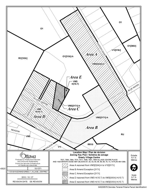
DETAILS OF RECOMMENDED ZONING DOCUMENT 2
- Rezone the subject property as shown in Document 1 as follows:
- Area A from VM3[324r]-h to V1E[617r]
- Area D and E from VM3 H(10.7) to VM3[XXXr] H(10.7)
- Delete Exception [324r] from Section 240.
- Amend Exception [317r] of Section 240 as follows:
- Add to Column IV (Land Uses Prohibited):
- dwelling unit
- Delete from Column V (Provisions):
- maximum of 2 dwelling units per commercial use located in the upper
storeys above any commercial use
- Add a new exception, VM3[XXXr], to Section 240 including the following:
- Land Uses Prohibited:
- apartment dwelling, low
rise
- bed and breakfast
- converted dwelling
- detached dwelling
- duplex dwelling
- dwelling unit
- home-based business
- home-based daycare
- linked-detached dwelling
- multiple attached dwelling
- residential care facility
- retirement home
- retirement home, converted
- rooming house
- rooming house, converted
- rooming unit
- secondary dwelling unit
- semi-detached dwelling
- stacked dwelling
- three-unit dwelling