|
3.
ZONING - 3664
GREENBANK ROAD AND PART OF 3640 GREENBANK ROAD ZONAGE – 3664, chemin greenbank et partie du
3640, chemin greenbank |
Committee recommendation
That Council approve an
amendment to the Zoning By-law 2008-250 to change the zoning of 3664 Greenbank
Road and Part of 3640 Greenbank Road from DR (Development Reserve Zone) to
O1 (Parks and Open Space Zone), R3Z (Residential Third Density Subzone Z), R3Z
[xxxv] (Residential Third Density Subzone Z Exception xxxv), R3Z [xxxw]-h
(Residential Third Density Subzone Z Exception xxxw with a holding symbol), R3Z
[xxxx]-h (Residential Third Density Subzone Z Exception xxxx with a holding
symbol), R3Z [xxxy]-h (Residential Third Density Subzone Z Exception xxxy with
a holding symbol), and R5Z [xxxz]-h (Residential Fifth Density Subzone Z
Exception xxxz with a holding symbol) as shown in Document 1 and as detailed in
Document 2.
Recommandation du comité
Que le Conseil approuve une modification au Règlement
de zonage 2008-250 afin de changer la désignation de zonage du 3664, chemin
Greenbank et d’une partie du 3640, chemin Greenbank de DR (Zone d’aménagement
futur) à O1 (Zone de parc et d’espace vert), R3Z (Zone résidentielle de densité
3, sous-zone Z), R3Z [xxxv] (Zone résidentielle de densité 3, sous-zone Z et
exception xxxv), R3Z [xxxw]-h (Zone résidentielle de densité 3, sous-zone Z,
exception xxxw dotée du symbole d’aménagement différé), R3Z [xxxy]-h (Zone
résidentielle de densité 3, sous-zone Z, exception xxxy dotée du symbole
d’aménagement différé) et R5Z [xxxz]-h (Zone résidentielle de densité 5,
sous-zone Z, exception xxxz dotée du symbole d’aménagement différé) comme il
est indiqué dans le Document 1 et expliqué en détail dans le Document 2.
Documentation
1.
Deputy
City Manager's report, Infrastructure
Services and Community Sustainability, dated 12 January 2011 (ACS2011-ICS-PGM-0025).
Report to/Rapport au :
Comité de l'urbanisme
and Council / et au Conseil
12 January 2010 / le 12 janvier 2010
Submitted by/Soumis par :
Nancy Schepers, Deputy City Manager/Directrice
municipale adjointe, Infrastructure Services
and Community Sustainability/Services d’infrastructure et Viabilité des
collectivités
Contact
Person/Personne-ressource : Derrick Moodie, Manager/Gestionnaire intérimaire,
Development Review-Suburban Services/Examen des projets d'aménagement-Services
suburbains, Planning and Growth Management/Urbanisme et Gestion de la
croissance
(613)
580-2424, 15134 Derrick.Moodie@ottawa.ca
|
SUBJECT: |
ZONING - 3664 GREENBANK ROAD AND PART OF 3640 GREENBANK ROAD
(FILE NO. D02-02-09-0106) |
|
|
|
|
OBJET : |
ZONAGE – 3664, chemin greenbank et partie
du 3640, chemin greenbank |
REPORT RECOMMENDATIONS
That the Planning Committee recommend Council approve
an amendment to the Zoning By-law 2008-250 to change the zoning of 3664 Greenbank
Road and Part of 3640 Greenbank Road from DR (Development Reserve Zone) to
O1 (Parks and Open Space Zone), R3Z (Residential Third Density Subzone Z), R3Z [xxxv]
(Residential Third Density Subzone Z Exception xxxv), R3Z [xxxw]-h (Residential
Third Density Subzone Z Exception xxxw with a holding symbol), R3Z [xxxx]-h
(Residential Third Density Subzone Z Exception xxxx with a holding symbol), R3Z
[xxxy]-h (Residential Third Density Subzone Z Exception xxxy with a holding
symbol), and R5Z [xxxz]-h (Residential Fifth Density Subzone Z Exception xxxz
with a holding symbol) as shown in Document 1 and as detailed in Document 2.
RECOMMANDATIONS
DU RAPPORT
Que
le Comité de l'urbanisme recommande au Conseil d’approuver une modification au
Règlement de zonage 2008-250 afin de changer la désignation de zonage du 3664,
chemin Greenbank et d’une partie du 3640, chemin Greenbank de DR (Zone
d’aménagement futur) à O1 (Zone de parc et d’espace vert), R3Z (Zone
résidentielle de densité 3, sous-zone Z), R3Z [xxxv] (Zone résidentielle de
densité 3, sous-zone Z et exception xxxv), R3Z [xxxw]-h (Zone résidentielle de
densité 3, sous-zone Z, exception xxxw dotée du symbole d’aménagement différé),
R3Z [xxxy]-h (Zone résidentielle de densité 3, sous-zone Z, exception xxxy
dotée du symbole d’aménagement différé) et R5Z [xxxz]-h (Zone résidentielle de
densité 5, sous-zone Z, exception xxxz dotée du symbole d’aménagement différé)
comme il est indiqué dans le Document 1 et expliqué en détail dans le Document
2.
BACKGROUND
The subject property
is 30.5 hectares in size, situated approximately 200 metres south of the
intersection of Greenbank Road and Cambrian Road.
The
land is currently vacant and dominated by agriculture fields with small areas
of woodland, forest and hedgerows. Immediately
to the north are lands of a recently developed residential subdivision known as
“Half Moon Bay North”, to the east are lands of a planned residential
subdivision known as “Stonebridge Phase 11”, to the south are vacant urban
lands and to the west are rural lands.
Purpose of Zoning Amendment
The purpose of this Zoning By-law
Amendment is to allow for the development of a new subdivision, known as “The Meadows,” which
contains
approximately 581 dwelling units in the form of single-detached, semi-detached,
multiple attached and stacked dwelling units and two park blocks. The related plan of subdivision application (File No. D07-16-09-0037) was
recently draft approved.
The subject property is currently zoned DR (Development Reserve) under Zoning By-law 2008-250. The purpose of the Development Reserve Zone is to recognize lands intended for future urban development while allowing limited interim uses.
The proposed amendment is to
change the existing zoning from DR (Development Reserve) to the following parent
zones: O1 (Parks and Open Space Zone), R3Z (Residential
Third Density Subzone Z), and R5Z (Residential Fifth Density Subzone Z).
DISCUSSION
Official Plan and Community Design Plan
The
lands are designated as General Urban Area in the Official Plan and are located
in Area 3 of the Barrhaven South Community Design Plan (CDP) that received
Council approval in June 2006. The CDP requires that
low, medium and high density residential units, a portion of a community park
and a portion of the neighbourhood park be developed on the subject lands. The Land Use Plan and Demonstration Plan in
the CDP illustrate how the mix of units and densities can be distributed over
the entire community in order to meet the Official Plan target of at least 29
units per hectare.
Proposed Draft Plan of Subdivision
The proposed draft plan of subdivision
includes a mix of housing types with an overall density of approximately 30.1
units per net hectare. The distribution of residential uses and parks is consistent
with the land use designation in the CDP. The proposed subdivision includes a
road network of a grid pattern with sidewalks along most streets to connect
residential uses with amenities such as parks, schools and a community centre.
The proposed transportation network aligns with the CDP policy for a walkable and connected community.
The proposed zone
for Area A (as shown on Document 1) is O1 – Parks and Open Space Zone, to allow
a community park and a neighbourhood park.
The proposed parent zone for Areas B, C, D, E and F is R3Z – Residential
Third Density Subzone Z, which permits a range of residential uses including
single-detached, semi-detached and multiple attached dwellings. The proposed parent zone for Area G is R5Z –
Residential Fifth Density Subzone Z, which permits a range of medium to high
density residential uses including stacked dwellings.
An exception is proposed for Areas C, E, F and G to specify a minimum distance of 5.5 meters between a building foundation to a front lot line or a corner lot line. It is intended to address concerns relating to sensitive marine clay soils that are found in the subdivision specifically in Areas C, E, F and G. The required distance helps ensure trees planted in areas that contain sensitive marine clay soils will be located a sufficient distance from building foundations so that the potential of the trees’ rooting system to undermine building foundations, which can occur in such soils, can be minimized. The exception for the foundation setback is in accordance with urban design guidelines in the CDP, which provides that yard setbacks along streets shall be in the range of 3-6 meters to establish a strong street edge. The parent zone will continue to dictate the setbacks for the remainder of the buildings such as the private garage entrance setback, as set out in the endnotes.
A holding symbol is proposed for Areas D, E, F and G to recognize that although the proposed land use and zoning in these areas are regarded as appropriate, the drainage area identified in the original Barrhaven South Master Servicing Study has been modified. As a result, development may not occur and the holding symbol may not be lifted in these areas until the aforementioned Master Servicing Study is updated and approved.
An additional
holding provision is proposed for Areas F and G to recognize that parts of these
areas are located on the edge of 300-metre setback from a Sand and Gravel
Resource Area, as designated in the Official Plan. The policies under the Official Plan Sections
3.7.4 and 3.6.1, as well as Section 7.8.3 under the CDP, specify that
development of potentially conflicting lands uses (such as the creation of new
lots or rezoning to permit dwellings) shall not be considered within 300 metres
of a Sand and Gravel Resource Area unless an Impact Assessment Study is
completed to demonstrate the compatibility between the development and the
mineral aggregate operation including any future expansion in depth or extent
will not be affected by the development.
The policies allow a scenario of a conditional zoning to consider
development with adequate buffering or separation distance. By placing a holding provision on Areas F and
G, the development may not occur in these areas until an Impact Assessment Study
is submitted and approved. Further the
draft plan of subdivision shows Areas F and G as “Blocks” and not “Lots”, which
will require additional planning applications prior to these properties being
severed or transferred.
Summary
The proposed
land uses and density are consistent with the policies and Land Use Plan in the CDP. The proposed parent zones are suitable to ensure
development in accordance with the designated uses. The exception and holding
provisions are necessary and sufficient to address concerns as noted
above. Staff recommend
approval.
The related plan of subdivision
application (File No. D07-16-09-0037) was recently draft approved.
ENVIRONMENTAL IMPLICATIONS
The subject property has been
identified as the potential habitat for the Bobolink, a bird species, which is
protected as a threatened species under the Endangered
Species Act. Through subdivision draft approval conditions an Environmental
Impact Statement is required to be submitted to assess the habitat potential.
The Rideau Valley Conservation
Authority commented on works related to watercourses and municipal drains.
Those comments have been incorporated into the subdivision draft approval
conditions.
RURAL IMPLICATIONS
The subject property is adjacent to the General Rural Area to the southwest.
CONSULTATION
Notice of this application was carried out in accordance with the City's Public Notification and Consultation Policy. Consultation details are included in Document 3.
COMMENTS BY THE WARD COUNCILLOR(S)
The Ward Councillor is aware of this application.
LEGAL/RISK MANAGEMENT IMPLICATIONS
There are no legal/risk management implications associated with this report.
CITY STRATEGIC PLAN
The proposed development is in harmony with the City Strategic Plan in that it provides a mix of various dwelling types which contribute to a range of choice of housing. The grid layout of the development helps create a walking, transit, and cycling-oriented community. The infrastructure required for the development is planned to be built or improved as needed to service the growth.
TECHNICAL IMPLICATIONS
FINANCIAL IMPLICATIONS
There are no direct financial implications associated with this report.
APPLICATION PROCESS TIMELINE STATUS
The application was not processed by the "On Time Decision Date" established for the processing of Zoning By-law amendments due to the need to review the related draft plan of subdivision application prior to the approval of this Zoning By-law amendment application.
SUPPORTING DOCUMENTATION
Document 1 Location Map
Document 2 Details of Recommended Zoning
Document 3 Consultation Details
DISPOSITION
City Clerk and Solicitor Department, Legislative Services to notify the owner, applicant, OttawaScene.com, 174 Colonnade Road, Unit #33, Ottawa, ON K2E 7J5, Ghislain Lamarche, Program Manager, Assessment, Financial Services Branch (Mail Code: 26-76) of City Council’s decision.
Planning and Growth Management to prepare the implementing by-law, forward to Legal Services and undertake the statutory notification.
Legal Services to forward the implementing by-law to City Council.
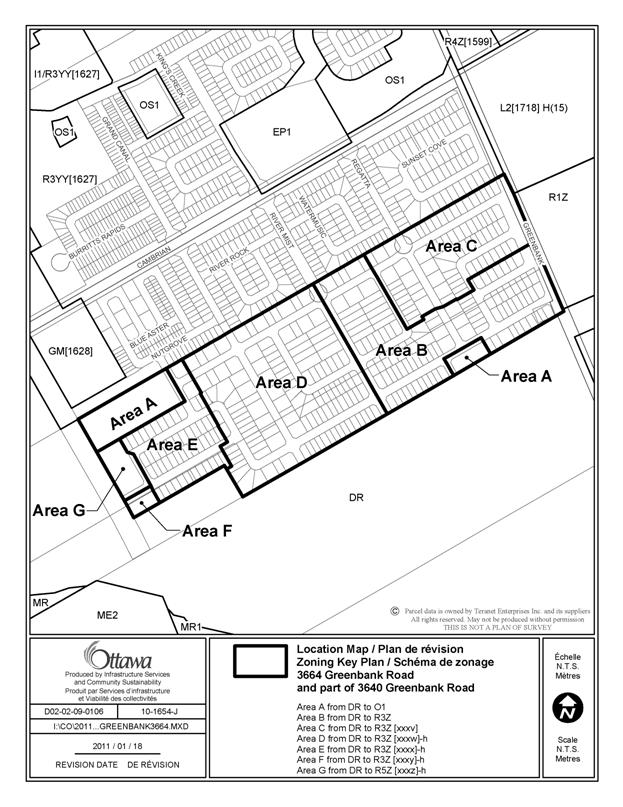
LOCATION MAP DOCUMENT 1
DETAILS OF RECOMMENDED ZONING DOCUMENT 2
Proposed Changes to the Comprehensive Zoning By-law
1.
That the lands known
municipally as part of 3640 Greenbank Road and 3664 Greenbank Road, shown as
Areas A to G in Document 1, be rezoned as follows:
Area A from DR to O1
Area B from DR to R3Z
Area C from DR to R3Z [xxxv]
Area D from DR to R3Z [xxxw]-h
Area E from DR to R3Z [xxxx]-h
Area F from DR to R3Z [xxxy]-h
Area G from DR to R5Z [xxxz]-h
2.
Area C,
R3Z [xxxv]:
- minimum front and corner side yard setback for a building foundation: 5.5 m
3.
Area D,
R3Z [xxxw]-h:
- the holding symbol may only be lifted until such time as the updated Barrhaven South Master Servicing Study is approved by the City.
4.
Area E, R3Z
[xxxx]-h
- minimum front and corner side yard setback for a building foundation: 5.5 m
- the holding symbol may only be lifted until such time as the updated Barrhaven South Master Servicing Study is approved by the City.
5.
Area F, R3Z
[xxxy]-h
- minimum front and corner side yard setback for a building foundation: 5.5 m
- the holding symbol may only be lifted until such time as:
- the updated Barrhaven South Master Servicing Study is approved by the City.
- an Impact Assessment Study which demonstrates the compatibility between the residential uses and the mineral aggregate operation, is approved by the City.
6.
Area G,
R5Z [xxxz]-h
- minimum front and corner side yard setback for a building foundation: 5.5 m
- the holding symbol may only be lifted until such time as:
- the updated Barrhaven South Master Servicing Study is approved by the City.
- an Impact Assessment Study which demonstrates the compatibility between the residential uses and the mineral aggregate operation, is approved by the City.
CONSULTATION DETAILS DOCUMENT
3
NOTIFICATION AND CONSULTATION PROCESS
Notification and public consultation was undertaken in accordance with the Public Notification and Public Consultation Policy approved by City Council for Zoning By-law amendments.
ADVISORY COMMITTEE COMMENTS
Ottawa Forests and Greenspace Advisory Committee (Summary):
“Although the treed areas are not large woodlands, it would be beneficial to conserve them as part of the proposed parks and school grounds: After all, there is no sense in clear-cutting fully mature treed areas only to lay down grass and plant new trees in the end. The continued argument that grade raises prevent the retention of trees is counterproductive. The planning of the community is supposed to integrate the natural elements of the site, “Design with Nature”, and incorporate the significant vegetation like Oaks and Maples of 50cm dbh and larger.
“We recommend that the two parks and school sites be situated where the mature treed areas are located, to take full advantage of the natural features of the property and demonstrate the integration of the existing mature vegetation can be incorporated into the proposed development.”
Staff response
A Tree Conservation Report was submitted which suggests that due to the insignificant size and species of the existing vegetation, as well as the proposed grading raise of one to two meters, tree retention is not possible on the subject site. This report was reviewed by the City Forester and deemed acceptable. The Urban Tree Conservation By-law 2009-200 is applicable to the subject property. The conditions for draft approval of the related subdivision require the applicant to proceed to tree-cutting by phases and update and refine the Tree Conservation Report to meet the requirements outlined in Schedule A of the Urban Tree Conservation By-law (2009-200) prior to registration of each phase of the subdivision.
The proposed location of parks and schools is consistent with the Council approved Barrhaven South Community Design Plan.