|
2. JOHNSTON
ROAD LAND USE STUDY; CITY-INITIATED ZONING – 3140 CONROY ROAD AND PARTS OF
3138 CONROY ROAD, 3142 CONROY ROAD AND 1555 JOHNSTON ROAD; AND ZONING BY LAW
2008-462 - APPEAL TO THE ONTARIO MUNICIPAL BOARD FOR THE NORTHERN PART OF
3130 CONROY ROAD ÉTUDE
D’UTILISATION DU SOL DANS LE SECTEUR DU CHEMIN JOHNSTON - MODIFICATIONS DE
ZONAGE À L’INITIATIVE DE LA VILLE – 3140, CHEMIN CONROY ET PARTIES DU 3138,
CHEMIN CONROY, 3142, CHEMIN CONROY ET 1555, CHEMIN JOHNSTON; ET RÈGLEMENT DE
ZONAGE 2008-462 – APPEL INTERJETÉ DEVANT LA COMMISSION DES AFFAIRES
MUNICIPALES DE L’ONTARIO CONCERNANT LA PARTIE NORD DU 3130, CHEMIN CONROY |
Committee recommendationS
That Council:
1.
Approve The Johnston Road Concept Plan, Development
Principles and Design Guidelines as Council’s direction to guide the future
development of the lands, generally located on either side of the CN railway
tracks, between Albion Road and Conroy Road, as shown and detailed in Document
2.
2.
Approve an amendment to the Zoning By-law
2008-250 to change the zoning for 3140 Conroy Road and part of 3142 Conroy Road
from IH – Heavy Industrial to IL – Light Industrial; to change the zoning for
part of 1555 Johnston Road from R3V[593] – Residential Third Density Subzone V
Exception Zone to IL – Light Industrial Zone; and to change the zoning for part
of 3138 Conroy Road from IH – Heavy Industrial to IH[xxxx] – Heavy Industrial
Exception Zone as shown in Document 3
and as detailed in Document 4.
3.
Approve the
repealing of subsection 1(a) and Attachment 1 of By-law 2008-462 regarding the
lands at 3130 Conroy Road, shown as “Area A” in Document 3, to resolve an
appeal to By-law 2008-462.
4.
Authorize
the City Clerk and Solicitor to implement Recommendation 3 either through
by-law enacted by Council or through an Order of the Ontario Municipal Board.
RecommandationS du comité
Que le Conseil :
1.
approuve le Plan conceptuel, les Principes d’aménagement et les Lignes directrices
de conception du chemin Johnston en tant que documents devant guider
l’action du Conseil en ce qui concerne l’aménagement futur des terrains
globalement situés de part et d’autre des voies ferrées du Canadien National, entre
les chemins Albion et Conroy, comme l’illustre et le précise le document 2.
2.
approuve une modification au Règlement de zonage 2008-250 visant à faire
passer la désignation de zonage du 3140, chemin Conroy, et d’une partie du 3142, chemin
Conroy, de IH – Zone d’industrie lourde, à IL – Zone d’industrie légère; à
faire passer la désignation de zonage d’une partie du 1555, chemin Johnston, de
R3V[593] – Zone résidentielle de densité 3, sous-zone V, zone d’exception, à IL
– Zone d’industrie légère; et à faire passer la désignation de zonage d’une
partie du 3138, chemin Conroy, de IH – Zone d’industrie lourde, à IH[xxxx] – Zone
d’industrie lourde, zone d’exception, comme l’illustre le document 3 et le précise le document 4.
3.
approuve l’abrogation du paragraphe 1(a)
et de l’annexe 1 du Règlement 2008-462 concernant les terrains situés au 3130, chemin
Conroy, désignés « secteur A » dans le document 3, afin de résoudre
un appel interjeté au sujet du Règlement 2008-462.
4.
autorise le greffier municipal et
chef du contentieux à mettre en œuvre la recommandation 3 au moyen d’un
règlement pris par le Conseil municipal ou d’une ordonnance de la Commission
des affaires municipales de l’Ontario.
Documentation
1.
Deputy
City Manager's report, Infrastructure
Services and Community Sustainability, dated 8 March 2011 (ACS2011-ICS-PGM-0045).
2.
Extract
of Draft Planning Committee Minutes of 29 March 2011.
Report to/Rapport au :
Comité de l'urbanisme
and Council / et au Conseil
08 March 2011 / le 08 mars 2011
Submitted by/Soumis par :
Nancy Schepers, Deputy
City Manager/Directrice municipale adjointe, Infrastructure Services
and Community Sustainability/Services d’infrastructure et Viabilité des
collectivités
Contact Person/Personne-ressource : Richard Kilstrom,
Manager/Gestionnaire,
Policy Development and Urban Design/Élaboration de la politique et
conception urbaine, Planning and Growth Management/Urbanisme et Gestion de la
croissance Élaboration
de la politique et conception urbaine
(613) 580-2424 x22653, Richard.Kilstrom@ottawa.ca
REPORT RECOMMENDATIONS
That the Planning Committee
recommend Council:
1.
Approve The Johnston Road Concept Plan, Development
Principles and Design Guidelines as Council’s direction to guide the future
development of the lands, generally located on either side of the CN railway
tracks, between Albion Road and Conroy Road, as shown and detailed in Document
2.
2.
Approve an amendment to the Zoning By-law
2008-250 to change the zoning for 3140 Conroy Road and part of 3142 Conroy Road
from IH – Heavy Industrial to IL – Light Industrial; to change the zoning for
part of 1555 Johnston Road from R3V[593] – Residential Third Density Subzone V
Exception Zone to IL – Light Industrial Zone; and to change the zoning for part
of 3138 Conroy Road from IH – Heavy Industrial to IH[xxxx] – Heavy Industrial
Exception Zone as shown in Document 3
and as detailed in Document 4.
3.
Approve the
repealing of subsection 1(a) and Attachment 1 of By-law 2008-462 regarding the
lands at 3130 Conroy Road, shown as “Area A” in Document 3, to resolve an
appeal to By-law 2008-462.
4.
Authorize
the City Clerk and Solicitor to implement Recommendation 3 either through
by-law enacted by Council or through an Order of the Ontario Municipal Board.
RECOMMANDATIONS DU RAPPORT
Que le Comité de l’urbanisme
recommande au Conseil :
1.
D’approuver le Plan conceptuel, les Principes d’aménagement et les Lignes directrices
de conception du chemin Johnston en tant que documents devant guider
l’action du Conseil en ce qui concerne l’aménagement futur des terrains
globalement situés de part et d’autre des voies ferrées du Canadien National, entre
les chemins Albion et Conroy, comme l’illustre et le précise le document 2.
2.
D’approuver une modification au Règlement de zonage 2008-250 visant à
faire passer la désignation de zonage du 3140, chemin Conroy, et d’une partie
du 3142, chemin Conroy, de IH – Zone d’industrie lourde, à IL – Zone
d’industrie légère; à faire passer la désignation de zonage d’une partie du 1555,
chemin Johnston, de R3V[593] – Zone résidentielle de densité 3, sous-zone V,
zone d’exception, à IL – Zone d’industrie légère; et à faire passer la
désignation de zonage d’une partie du 3138, chemin Conroy, de IH – Zone
d’industrie lourde, à IH[xxxx] – Zone d’industrie lourde, zone d’exception,
comme l’illustre le document 3 et le précise le document 4.
3.
D’approuver l’abrogation du
paragraphe 1(a) et de l’annexe 1 du Règlement 2008-462 concernant les terrains
situés au 3130, chemin Conroy, désignés « secteur A » dans le
document 3, afin de résoudre un appel interjeté au sujet du Règlement 2008-462.
4.
D’autoriser le greffier municipal et
chef du contentieux à mettre en œuvre la recommandation 3 au moyen d’un
règlement pris par le Conseil municipal ou d’une ordonnance de la Commission
des affaires municipales de l’Ontario.
BACKGROUND
The Johnston Road Land Use Study (JRLUS) was initiated by the City in 2007 because of increasing development pressures for large format retail uses at the northwest corner of Johnston and Conroy Road. The purpose of this planning exercise was to examine the current policy and zoning framework affecting the subject lands, to determine the most appropriate land use, road pattern, density, and any amendments that would be required. Resulting from the Study are a concept plan, development principles, design guidelines, zoning amendments and a resolution of an outstanding appeal to the Ontario Municipal Board.
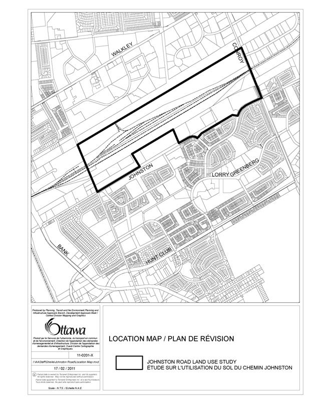
The study area is bounded by a Hydro One corridor on the north, Conroy Road on the east, Albion Road on the west, and Johnston Road on the south, as shown on Document 1. It encompasses approximately 120 hectares of land, with the majority of lands being vacant or under-utilized. The study area is somewhat unique in that almost half the lands, or 55 hectares, were part of the former Walkley Rail Yard. Land uses in and around the study area include industrial uses to the east and west, and the Greenboro/Hunt Club Park residential community south of Johnston Road. A 90-metre-wide hydro corridor separates the northern part of the study area from both the Heron Gate residential community and from the west part of the Ottawa South Business Park. The major land owners and land uses within the study area are as follows:
· Canadian Pacific (CP) owns the northern portion of the former Walkley Rail Yard, accounting for approximately 23 hectares, or approximately 20 per cent of the total study area. The site is largely vacant and void of tracks, save and except for a building and short track currently leased by the City of Ottawa for maintenance purposes of its O‑Train cars.
· Canadian National (CN) owns the only operating railway tracks, which account for 11 hectares of land, and three buildings on the site. No change is proposed for this property.
· Claridge Homes (Elgin) Inc. (referred to as “Claridge” later on) owns a 19-hectare property, south of and adjacent to the existing railway tracks, which is predominantly vacant, except for two buildings and some remaining railway spurs. Claridge also owns approximately 4.0 hectares of vacant land at the northeast corner of Johnston Road and Albion Road South.
· The City of Ottawa owns lands north and south of the railway tracks comprised of a water tower, snow disposal facility, parks and open space, a skateboard park, the Conroy Woods and the Greenboro Turtlehead Nature Area – preservation of these two Urban Natural Features is one of the development principles resulting from the JRLUS. A surface operations yard also is proposed at the corner of Thurston, west of Conroy. Total City ownership accounts for approximately 36 hectares, or 30 per cent of the overall study area.
· Properties with access to Albion Road North and South are held by various land owners and are comprised of buildings containing office and warehouse uses, and some outdoor storage yards. Land area for these sites totals approximately 12 hectares.
· Conroy Road Development Inc. owns approximately 12 hectares of vacant land located at the northwest corner of Conroy Road and Johnston Road.
DISCUSSION
Recommendation 1
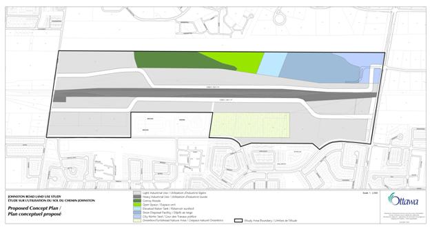
Recommendation 1 is to approve The Johnston Road Concept Plan, Development Principles and Design Guidelines as Council’s policy direction for the future development of the planning area. Combined together, all three will foster development that ensures the area’s future as a sound and economically viable place of business offering a variety of employment opportunities meeting a high level of urban site planning, architecture and landscape design, while recognizing a railway facility in its midst. The primary purpose of The Johnston Road Concept Plan, Development Principles and Design Guidelines (Document 2) is to serve as a reference guide for planners, development proponents and architects, when initiating projects; and for City staff, community groups, residents and other interested stakeholders when assessing and commenting on the appropriateness of future development proposals.
The JRLUS area is strategically located in that it:
· is within the urban boundary and within the greenbelt;
· is in proximity to the Ottawa South Business Park which has less than 10 hectares of vacant land available for development;
· is within proximity to a planned major interchange of Hunt Club Road and Highway 417;
· is an area comprised of large blocks of vacant and under-utilized land with very few landowners; and
· has direct access to an arterial road.
Based on similar development in the Ottawa South Business Park, and generally two-storey buildings occupying 30 per cent of the total land area throughout the JRLUS area, a total gross floor area of 390,550 square metres could be achieved. This projection is based on a full build-out and includes only the industrial-zoned lands, including those that are vacant, developed and underdeveloped. It represents a moderate increase from the existing zoning development potential which has more IH – Heavy Industrial zoned lands. It will be many years, likely beyond the 20 year planning period of the City’s Official Plan, before this area achieves any semblance of build-out.
The proposed Concept Plan shown in Document 2 will:
· Be consistent with the Provincial Policy Statement and Official Plan policies for lands designated Employment Area;
· Facilitate the development of the lands in an effective and efficient manner while allowing for flexibility for block and lot size;
· Make use of existing infrastructure services and allow for orderly expansion where required;
· Provide an effective road network that maximizes effective transit use and facilitates traffic circulation to the existing road network with need for very little roadway modification to the existing transportation network;
· Establish pedestrian connectivity within the planned area and out to the surrounding area;
· Continue to protect the two designated Urban Natural Features;
· Support the preference for light industrial uses as established through the public consultation process; and
· Promote compatibility of new development where it is adjacent to or within proximity to existing residential development.
The following are the key characteristics of the Concept Plan:
· Two new local roads, one north and one south of the railway tracks, will be provided. While the location of the local roads is conceptual on the concept plan, each road must connect with both Albion Road and Conroy Road. The roads are to be developer-initiated and implemented through plan of subdivision approvals. The length or segment of road to be constructed at any one time will be determined through the subdivision approval process, subject to staff approval. Phased construction must consider appropriate servicing, surface operations, emergency access, and public transit.
· Block and lot sizes will be market driven and based on the desires of the landowner, with minimums established as per the Comprehensive Zoning By-law. The concept plan will retain this flexibility.
· For lands located near Conroy Road, south of the railway tracks, vehicular access to Johnston Road will be prohibited, with all vehicular access directed to the new local road.
· For lands located near the west side of the concept plan, south of the railway tracks and abutting the north side of Johnston Road, buildings will face Johnston Road with parking lots in behind; a driveway connecting to Johnston Road or to the new local road, will be determined at the time of submission of a development application with the aid of either a Transportation Brief or a Transportation Impact Study.
· The concept plan recognizes the preservation of the two designated Urban Natural Features.
· Through subdivision and site plan control submissions, linkages will be encouraged to pedestrian and cycling paths located and /or planned within proximity to the study area as identified in the Ottawa Pedestrian Plan and Ottawa Cycling Plan.
Development Principles and Design Guidelines
The Development Principles and Design Guidelines for this area are based on landscape and design guidelines created for other industrial business parks including those established for both the Ottawa South Business Park and the Hawthorne Business Park. They will address land use, open space, block patterns, pedestrian and cycling paths, buildings, interface with the public realm and the abutting residential community. The guidelines are intended to provide a more detailed description on the desired form of development in keeping with the development principles. The concept plan, principles and guidelines are contained in Document 2.
Implementation
The Johnston Road Concept Plan, Development Principles and Design Guidelines reflect Council’s vision to guide the future development for this industrial business park. Together, they shall be used as the framework to direct the preparation of all development applications.
In addition to the policies contained in the Official Plan for Employment Areas, this document also will be used as the evaluation tool when reviewing submissions in the development review process.
It is recognized that development, and consequently implementation of the Concept Plan, will likely be market-driven, phased, and based on the plans of the major land owners. The next steps in the process will include submission of the appropriate subdivision and site plan control applications, and all necessary technical studies.
Several high-level, or ‘desk top’
studies were undertaken in support of the JRLUS planning exercise, including
transportation, noise, geotechnical, natural environment and servicing. These studies also will be used to direct the
preparation of development applications insofar as the requirement for further
studies and infrastructure improvements, within and in proximity to the study
area. A summary of the studies is
provided in Document 5.
Recommendation 2
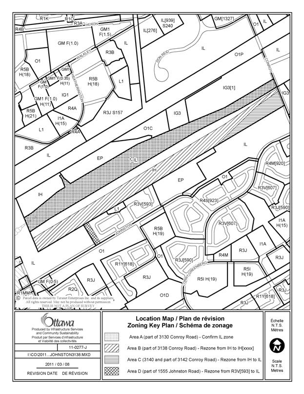
The JRLUS also provides the basis for several zoning amendments to the Comprehensive Zoning By-law for a limited number of properties located within the study area, as shown in Document 3 and as detailed in Document 4.
The proposed IL - Light Industrial Zone will provide the opportunity for job creation, and for a wide range of uses. The purpose of the IL zone is to permit a wide range of low impact light industrial uses, as well as office and office-type uses in a campus-like industrial park setting. Complementary uses occupying small sites on individual pads or in groupings as part of a small plaza, and limited sample and showroom space secondary to the manufacturing or warehousing of the primary use also are permitted. Retail uses as well as those which are likely to generate noise, fumes, odours or are hazardous or obnoxious are prohibited in the IL zone. Three properties on the south side of the railway will be rezoned to Light Industrial: part of 1555 Johnston Road to reflect the Employment Area designation; and, 3140 Conroy Road and part of 3142 Conroy Road, which currently are zoned Heavy Industrial.
Lands located adjacent to the south side of the railway tracks will be rezoned from Heavy Industrial to a Heavy Industrial exception zone. The proposed exception zone is based on a compromise reached with the landowner whereby certain uses that could generate noise, fumes, odours and are hazardous or obnoxious, will be prohibited, to be more in keeping with the Light Industrial zone. However, the exception will retain the existing zoning regulations or development standards found under the IH zone for minimum lot area and yard setbacks, and building height. This is found to be satisfactory in that the compatibility issue is resolved regarding land uses.
Recommendations 3 and 4
Recommendation 3 is to confirm a Light Industrial Zone for the northern part of the property known municipally as 3130 Conroy Road, located north of the CN railway tracks and south of the Hydro One corridor, between Conroy Road and Albion Road North. It is owned by Canadian Pacific and currently the subject of an outstanding appeal which has been put on-hold pending the outcome of the Johnston Road Land Use Study.
Recommendation 4 is to provide authorization to the City Clerk and Solicitor to determine the most appropriate method of implementing Council’s direction. Approval of recommendations 3 and 4 in this report would permit the matter to be resolved through a by-law enacted by Council or through an Order issued by the Ontario Municipal Board.
The Comprehensive Zoning By-law currently shows the site with an *IL – Light Industrial Zone, the asterisk indicating Pending Final Approval. The property had been previously zoned Heavy Industrial, and was inadvertently changed from IH – Heavy Industrial Zone to IL - Light Industrial Zone, between the May 2007 draft of the Comprehensive Zoning By-law and the final adopting by-law. When staff discovered the error, a correction was subsequently made in an anomaly report in November 2008 to change the property back to IH. Staff’s position at that time was that the request for an IL zone was premature and it was not Council’s intent to rezone the property to IL in advance of the completion of the JRLUS underway at the time. Now that the Study has been completed, staff have determined that the IL – Light Industrial Zone is the appropriate zoning for the subject lands, as it will prevent future heavy industrial uses and permit more employment-generating uses, including business park and office type uses. The change to IL will not impede the potential use of these lands for a transit corridor in the future, nor affect the existing maintenance facility currently leased by the City of Ottawa, as a rapid-transit network is generally permitted in all zones through Section 87 of the Zoning By-law.
ENVIRONMENTAL IMPLICATIONS
The Johnston Road Concept Plan, Development Principles and Design Guidelines will help foster development that is sustainable and reinforces protection of the Urban Natural Features located with the study area. The need for Environmental Impact Statements will be determined as per Official Plan policies at the consultation stage of proposed development applications.
RURAL IMPLICATIONS
N/A
CONSULTATION
A summary of the public consultation, including the comments received, is detailed in Document 6. Four public meetings were held between March, 2008 and November, 2009. More recently, City staff provided an update to the public at a community association meeting held in February, 2011. In addition, all stakeholders who participated at any of the four public meetings and/or submitted comments on the plan and/or zoning amendments were provided notification of the Planning Committee meeting and a copy of the staff report.
COMMENTS
FROM THE PUBLIC WORKS DEPARTMENT
The
Public Works Department has been consulted in the development of this report
and is supportive of the report recommendations. However, it is important to note that the
land surrounding the Conroy Road and Thurston Drive Snow Disposal Facility
should be developed in keeping with any guidelines associated with its use.
The
Public Works Department will work with the Planning and Growth Management
Department to implement the report recommendations subject to approval by
Council.
COMMENTS
BY THE WARD COUNCILLOR
1. If the community
feedback from the staff report indicates that the residents' understanding is
that these lands were to be zoned light industrial as shown on the map that
City Staff brought to the February 17th, 2011 South Keys/Greenboro Community
Association meeting, then we may need to pursue further amendments.
2 I want to ensure
that the Greenboro Turtlehead Nature Area is not adversely affected by future
development on abutting lands. Any future development that abuts the Greenboro
Turtlehead Nature Area must include protections for the feed and water flow
into this sensitive environmental area and protect the habitat, both flora and
fauna.
3. The community has an interest in preserving a trail on
the old rail spur in the north west area of the Johnston Road Lands.
4. I want to ensure that future development and the future
road network does not adversely affect existing residential areas to the south
of Johnston Road.
5. Please ensure that any future development incorporates
and adheres to the enhanced landscape and aesthetic business park requirements
as outlined in the Ottawa Business Park.
LEGAL/RISK MANAGEMENT
IMPLICATIONS
Should the recommendations be adopted and the rezoning provided for in Recommendation 2 be appealed to the Ontario Municipal Board, the duration of the hearing will be dependent upon the nature of the issues raised in the appeal.
As a City initiated rezoning, a determination by Council to vote against Recommendation 2 would not be subject to an appeal. However, as there is an outstanding appeal against By‑law 2008-462, that matter would likely proceed to a hearing. It would be the recommendation of Legal Services in such event that an outside planner be retained at an estimated cost of $15,000 to $20,000.
CITY STRATEGIC PLAN
The recommendations included within this report are in keeping with the following Planning and Growth Management Objectives:
(1) Manage growth and create sustainable communities by becoming leading edge in community and urban design
(2) Invest in programs and initiatives that improve Ottawa’s business climate, support job creation and enhance the city’s social and economic prosperity.
TECHNICAL IMPLICATIONS
FINANCIAL IMPLICATIONS
There are no direct financial implications associated with this report.
SUPPORTING DOCUMENTATION
Document 1 Location Map of Johnston Road Land Use Study
Document 2 Johnston Road Concept Plan, Development Principles and Design Guidelines
Document 3 Zoning Map
Document 4 Details of Recommended Zoning
Document 5 Summary of Supporting Studies
Document 6 Consultation Details
DISPOSITION
Regarding Recommendation 2, Planning and Growth Management Department to prepare the implementing by-law and forward to City Manager’s Office, Legal Services, and undertake the statutory notification.
Regarding Recommendations 3 and 4, Legal Services to prepare a repealing by-law to be enacted by Council or to be implemented through an Ontario Municipal Board Order.
Legal Services Branch to forward the implementing by-law(s) to City Council.
City Clerk and Solicitor Department, Legislative Services to notify the owners, consultants, appellants, interested residents; Ghislain Lamarche, Program Manager, Assessment, Financial Services Branch (Mail Code: 26-76); OFGAC c/o Stephanie Brown, Secretariat Services (Mail Code 01-71), of City Council’s decision.
JOHNSTON ROAD CONCEPT PLAN DOCUMENT
2
DEVELOPMENT PRINCIPLES AND DESIGN
GUIDELINES
CONCEPT
PLAN
DEVELOPMENT PRINCIPLES
The following development principles and design guidelines are to be used as the principle reference for the City to direct the preparation of development applications and to evaluate submissions in the development review process. Application of these principles and guidelines are meant to ensure that future development achieves a consistently high level of site planning, architecture and landscape design.
1. Be consistent with the Provincial Policy Statement and Official Plan policies for lands designated Employment Area.
2. Foster development that ensures the area’s future as a sound and economically viable place of business offering a variety of employment opportunities which meet a high level of urban design regarding site planning, architecture and landscape design, while recognizing the uniqueness of a railway facility in its midst.
3. Investigate and be prepared to take creative action for any opportunities to effectively use the existing railway lines to full advantage of both the Employment Area and the surrounding residential community.
4. Facilitate the development of the lands in an effective and efficient manner while allowing for a variety of block and lot sizes, while recognizing that the size of lots will be market-driven and based on the desires of the landowner, but as per minimums established by the Comprehensive Zoning By-law.
5. Support the preference for light industrial uses as established through the public consultation process.
6. Make use of existing infrastructure services and allow for orderly expansion where required.
7. Provide the opportunity to encourage and integrate efficient public transit service with pedestrian and cycling networks within the area and between new and existing development.
8. Provide two new local roads to provide maximum access for as much of the site as possible.
9. Reduce direct vehicular access to Johnston Road for lands located at both the northwest corner of Johnston and Conroy Road and the northeast corner of Johnston and Albion.
10. Encourage linkages to pedestrian and cycling paths as identified in the Ottawa Pedestrian Plan and Ottawa Cycling Plan through the development review process.
11. Maintain existing natural topographic features, distinctive land forms, vegetative and drainage characteristics as much as possible to enhance site development, including the retention of all existing large healthy trees, and substantial masses of mature shrubs.
12. Ensure that the Conroy Woods and the Greenboro Turtlehead Nature Area (GTNA) continue to be protected when considering new development proposals within the area by implementing any mitigation measures as required by supporting studies.
13. Promote a finished development setting that is cohesive and employs a formal landscape design to impart a pleasantly distinctive visual character for the area.
14. Ensure that development interfaces with the adjacent residential community in a sensitive manner, with building facades of new development oriented toward Johnston Road.
15. Create an environment which is physically compatible and aesthetically enhanced on those portions of individual properties which are visible to abutting residential areas through the use of landscape elements, such as berms, tree and shrub planting and decorative fencing, etc.
16. Develop an effective visual separation between new business park uses and nearby uncomplimentary or incompatible industrial, commercial, utility or other such uses.
17. Employ Crime Prevention Through Environmental Design (CPTED) techniques in all facets of site development review.
DESIGN GUIDELINES
The guidelines discuss how development can be sensitively integrated with the existing context, how it can contribute to the visual image of the area, and how it can address functional requirements of safe and efficient circulation. The guidelines recommend accentuating gateways and façade treatment along public rights-of-way. Key consideration is given to compatibility between new development in the Employment Area and the surrounding community. The guidelines also strive to reduce the visual prominence of associated parking areas by locating them at the rear of buildings or effectively screening them from adjacent pedestrian areas, residential areas and public streets. Effective linkages for pedestrians and cyclists will be accommodated through development review with the goal to create a barrier-free network that serves developments within the industrial park and the broader community system. Street trees planted in a consistent manner on all public boulevards will create a strong and cohesive visual identity for the whole industrial business park. Effective landscaping also will be used at gateway intersections leading into the industrial park, to screen unsightly elements, and to buffer adjacent residential uses from future industrial uses.
Road
Pattern and Development Blocks
1. Two new local roads will be constructed and aligned in an east - west direction, one north and one south of the railway tracks. These roads are to be developer-initiated and implemented through plan of subdivision approval.
2. At build-out, each road will connect to both Albion Road and Conroy Road to maximize public transit routing, provide more connectivity for cyclists and pedestrians, and improve public safety for emergency access.
3. The length or segment of road to be constructed at any one time will be determined through the subdivision approval process, subject to staff approval. Phased construction of the roads and/or blocks, must consider appropriate servicing, surface operations, emergency access, and efficient public transit.
4. Location of the two new local roads is conceptual. The alignments shown on the concept plan illustrate one way to provide access to as many individually owned, vacant and underutilized sites as possible, while minimizing traffic generation through existing neighbourhoods.
5. New development at the northwest corner of Conroy and Johnston Roads will have vehicular access provided via a new local road connecting directly to Conroy Road; however, pedestrian and cycling access to Johnston Road will be encouraged.
6. The most appropriate vehicular access for lands located near the west side of the concept plan, south of the railway tracks, is best determined through the development review process, and with the aid of a Transportation Brief or Transportation Impact Study as per City of Ottawa Transportation Impact Assessment guidelines. In either case, buildings will be encouraged to face Johnston Road, and to provide pedestrian access directly to Johnston Road.
7. All four, new intersections should be defined as well-articulated, visually enhancing gateway entries into the new employment area, either through significant landscape treatment and /or built form and siting of new buildings.
8. Existing development blocks vary in size, but overall, are large. A plan of subdivision will create the public roads and will also create smaller blocks or lots for marketing purposes and ownership. Minimum lot sizes are established through the Comprehensive Zoning By-law. The Johnston Road Concept Plan will maintain the flexibility that currently exists.
Permitted
Uses and Buildings
1. This concept plan will encourage a wide range of low-impact light industrial uses, as well as office and office-type uses in a campus-like industrial park setting, recognizing the existing open space, parks and urban natural features. The permitted uses are those listed in the respective zones as per the Comprehensive Zoning By-law, as amended herein, and include office, manufacturing, research and development, warehousing and distribution. A variety of complementary uses are also permitted, such as recreational, health and fitness uses and service commercial uses (e.g. convenience store, personal service business, restaurant, automobile service station and gas bar), occupying small sites on individual pads or in groupings as part of a small plaza, to serve the people working and living in the area, and passing traffic.
2. Orient buildings to front onto the public right-of-way and ensure that principal entries are clearly identifiable, visible from the street and universally accessible. Entries can be highlighted by designing extra-high lobby space, distinctive doorways and distinctive landscaped entry areas, and also by changing paving materials, textures or colour.
3. Ensure that facades which face Johnston Road and flank other streets, add interest through their architectural detail. Use the architectural details (e.g. windows, transoms, doorways) and choice of building material to articulate and break up the building mass.
4. Accentuate corner sites by designing buildings that relate to both street fronts and provide pedestrian access to the building from the corner.
5. Ensure that building setbacks permit the addition of significant landscaping and an enhanced streetscape treatment.
6. Avoid large blank walls on all facades, and encourage the use of real windows facing all public rights-of-way.
7. Ensure visibility into buildings from ground level facades facing public streets and the pedestrian realm. Walls should be highly transparent with windows and doors making up at least 30 per cent of the façade.
8. It is recognized that certain buildings will include programmatic uses that do not lend themselves to a highly transparent façade (e.g. loading areas). These buildings should be designed so that such uses are located along walls that face away from public streets and the pedestrian realm. The external surface of these walls must be designed to break up the visual size of the wall’s façade by using any of the following techniques:
a. modulating the façade,
b. using different building materials, colours, patterns, and textures within the building plane;
c. changing the roofline;
d. incorporating display windows;
e. designing buildings with distinct bases, middles, and upper storeys.
9. Employ high quality materials in the development of individual sites.
Parking, Loading and Service
1. Locate parking areas away from the new gateway entrances, and away from Johnston Road.
2. Locate surface parking at the rear of buildings so that the built form screens the parking area from public streets and from abutting residential uses.
3. Where parking cannot be located at the rear of buildings, a larger setback from the property line than the building setback will be required, and cars must be effectively screened from view.
4. Minimize the visual and micro-climatic effects of all parking and other large paved areas through the use of plant materials in combination with earth berms where practical.
5. Break up large parking areas into smaller ones (maximum of 25 parking spaces in a continuous row) with landscaped islands provided at the ends of parking space rows, each having a width of at least 3m and a minimum area of approximately 15 square metres to accommodate deciduous trees and low shrubs, or ground cover, other than grass, in place of shrubs.
6. For every four single rows of parking spaces, provide a landscaped centre median, having a minimum width of 2m, to be planted with trees and possibly shrubs.
7. Landscape the setback between parking areas and the public right-of-way with a row of trees, planted to create a continuous canopy, and understory shrub planting. Where possible, a second row of trees should be added. Plant spacing and planting choices must meet the intent of these guidelines to screen parking areas from view and to provide shade to city sidewalks for pedestrians. Planting may be combined with aesthetic berms, low fences or walls to achieve the desired screening. Screening must be effective in all seasons.
8. The number of access driveways will be minimized where possible through the encouragement of shared access to parking areas located between buildings that are located on separate properties.
9. Line the main private driveways with deciduous trees on one or both sides, spaced at an approximate spacing of 7m on centre.
10. All access to storage areas must be screened from view from the public street and from abutting residential uses, with the use of earth berms and landscaping. The screening must be effective in all seasons and landscaping should not exceed 1m in height.
11. Loading spaces must not face the Johnston Road right-of-way, and must be screened from view from the Johnston Road right-of-way, and from abutting residential uses.
12. Loading areas or garbage storage service areas must be at least 6m away from a front yard. When abutting residential uses, mitigation measures to address noise reduction and odour shall be taken, including the consideration of requiring interior garbage/recycling storage, greater setbacks from abutting property lines, and built structures around loading areas. (‘wing-walls’)
13. Locate loading, garbage and other services (transformers, utility meters, heating, ventilation and air conditioning equipment) in non-prominent locations that do not detract from the aesthetic appeal of the street, and are located away from the pedestrian realm and away from abutting residential uses.
14. Screen mechanical, service and utility areas from view using landscaping and/or materials that match the building. Where context sensitive, e.g. abutting residential or Johnston Road, enclose these elements within the building. Any roof-top equipment will be effectively screened utilizing suitable material complementary to the material used for the main building.
Landscaping Guidelines
Street trees planted in a consistent manner on all public boulevards will create a strong and cohesive visual identity for the whole industrial business park. Effective landscaping will be used at gateway intersections, to screen unsightly elements, and where necessary, to buffer adjacent residential uses from future industrial uses, and new industrial uses from existing uses that currently are not as visually appealing.
1. At least 30 per cent of the total area of the lot for each individual site development must be landscaped area.
2. Any portion of a site not covered by a building or hard surface material also shall be landscaped, even for sites where future buildings are proposed, and phased for a later date.
3. A minimum of approximately 35 per cent of all trees and a minimum of approximately 20 per cent of all shrubs planted on a site should be coniferous or broad leafed evergreens.
4. Use intensive planting along all public rights-of-way, between the curb and edge of right-of-way, in a consistent and distinctive formal pattern such that a continuous canopy or screen is created:
a. Plant any deciduous trees along the street at an approximate spacing of 6m on centre, while recognizing that tree spacing will vary with species selection;
b. Any combination of deciduous trees and coniferous trees along the street should be approximately 7.5m on centre.
5. Select plant species that are non-invasive, tolerant of urban conditions, and drought resistant, with preference given to native species that can meet these conditions.
6. A landscaped area with a minimum width of three metres is required along all property lines. Pedestrian walkways or cycling linkages can form part of this area.
7. The side property lines separating individual sites are to be defined by informal plantings of trees and shrubs, and at the adjacent streetline, a formal grouping of coniferous trees (minimum of two trees on each side of any side property line) shall be included with contrasting smaller plant materials linking the coniferous trees to the deciduous street trees.
8. Bio-swales should be investigated as a means of natural irrigation for any landscaped islands and landscaped setbacks along property lines.
9. Foundation planting for all buildings fronting Johnston Road will be encouraged.
10. Plantings of shrubs and/or other plant materials shall be encouraged along the front façade of all buildings, (unless the planting diminishes a distinctive architectural feature or effect) and along building walls in the vicinity of all main pedestrian spaces or walkways, keeping Crime Prevention Through Environmental Design principles in mind.
11. Use compatibly designed street furnishings and other hard landscape elements within the public streetscape, and on private sites (e.g. lighting, address and signage elements), and employ similar planting designs along the streetscape and on the adjacent portions of private sites (e.g. tree species selection and rhythm along roads and driveways, property line definition plantings, entrance planting features) in order to create strong visual unity for the overall employment area.
12. Establish a landscaped buffer around the edges of any new development to preclude incompatible or uncomplimentary views onto other sites within the employment area, such as along the railway lands or outdoor storage areas, and any other uses that currently do not add to the aesthetically pleasing environment that is sought through this Plan.
13. Develop small courtyards or plazas at the main entrance to all buildings; and make these spaces sheltered from the elements and visible from the street and/or from the beginning of the main vehicular driveway leading to parking areas in the rear.
14. All building entrances and related entry courts and plazas are to be well-lit, sheltered and clearly visible when entering the site, and are to be defined by landscape elements.
15. Use plantings or appropriately sized shrubs, and/or trees to visually soften extensive lengths of building walls (e.g. 9m sections or greater) which have few windows or other substantial architectural relief, especially when adjacent to or readily visible to residential uses.
Pedestrian and Cycling
Environment
As the industrial business park develops, it is essential to create a well-defined pedestrian and cycling environment along all public roads and within the individual development sites.
1. Through the development review process for subdivision and site plan applications, create a pedestrian and cycling system incrementally, which at build-out, will serve the entire industrial business park and provide opportunity for future linkages to the surrounding communities, public areas, community amenities and transit stops.
2. Provide for the future allocation of pathway blocks at regular intervals in the industrial park to access the future pathways as identified by the Ottawa Cycling Plan and Ottawa Pedestrian Plan, at the time of subdivision and/or site plan control applications.
3. Build sidewalks or multi-use pathways on at least one side of the new roads in accordance with City standards.
4. Provide for appropriate pedestrian and cycling connections to all new development immediately adjacent to the north side of Johnston Road, through the site plan and subdivision review processes.
5. Design for on-road cycling for the new roads.
6. Provide a physical environment that is safe, convenient, universally accessible to all users, and generally pleasant for pedestrian users, such that walkways have a minimum width of at least 1.5m and at least 2m for main walkways leading to a main building entrance.
7. Ensure that all areas of the vehicular and pedestrian circulation system are lit to provide sufficient visibility for safety and security, preferably with free standing fixtures that are task oriented, and reduce glare and light spill-over. The positioning of light standards shall be used to help delineate routes and provide spatial definition for different functional areas.
8. Sign all pedestrian pathway and cycling linkages leading to those nearby pathways identified in the Ottawa Pedestrian Plan and Ottawa Cycling Plan, when built.
9. Provide seating and shaded areas along pathways at roughly 200m intervals.
10. Clearly highlight street crossings through special pavement treatment for pedestrians and cyclists.
11. Provide bicycle parking in highly visible locations close to well-lit building entrances and that are connected to the pedestrian system.
ZONING MAP DOCUMENT 3
DETAILS OF RECOMMENDED ZONING DOCUMENT 4
Proposed
Changes to the Comprehensive Zoning By-law
1. Rezone the lands shown on Document 3 as follows:
- Area B is rezoned from IH to IH[XXXX];
- Area C is rezoned from IH to IL; and,
- Area D is rezoned from R3V[593] to IL.
2. Add a new exception, IH[XXXX], to Section 239 and including the following text in Column IV:
“- Automobile body shop
- Crematorium
- Leaf and yard waste composting facility
- Kennel
- Waste processing and transfer facility”
SUMMARY OF SUPPORTING STUDIES DOCUMENT 5
Several high-level, or ‘desk top’ studies were undertaken in support of the JRLUS planning exercise. These studies also will be used to direct the preparation of development applications insofar as the requirement for further studies and infrastructure improvements, within and in proximity to the study area. These studies are on file with the City Clerk:
· Johnston Road Land Use Transportation Study Report and Appendices
Appendix A, Appendix
B, Appendix
C, Appendix
D, Appendix
E,
Appendix F, Appendix G, Appendix H, Appendix I, Appendix J, Appendix K,
· Johnston Road Land Use Study Noise Assessment
· Review of Natural Environment Existing Conditions Johnston Road Study Area
· Johnston Road Land Use Study: Servicing Feasibility Study
· Geotechnical Inventory and Evaluation Johnston Road Land Use Study
Transportation
To support the recommendations of the JRLUS, a high-level transportation study was undertaken to examine transportation conditions, specifically the current needs and from a high level, the future transportation requirements of the study area. The transportation study fulfils Phases 1 and 2 of the Municipal Class Environmental Assessment (EA) in support of the JRLUS. The final report outlines the analysis of existing conditions and the transportation assessment undertaken for the potential forecast conditions based on the proposed Concept Plan for the study area. The recommended concept plan can be accommodated without significant additions/modifications to the existing transportation network, i.e. no additional roads other than the two proposed within the study area are required.
Upon submission of a development proposal which triggers the requirement for either a Transportation Brief or Transportation Impact Study as per City of Ottawa Transportation Impact Assessment guidelines, the City will evaluate it against the findings within this transportation report. Specific road improvement projects may be identified through future development proposals, such as traffic control signal timing changes, turning lanes, etc., to serve the growth projected for this area over the planning period.
Noise
Noise generated from traffic on Johnston Road was an issue for some residents living on Fernwood Drive and Viking Drive, whose back yards abut the south side of Johnston Road, west of the study area. At their request, a noise assessment of Johnston Road between Southgate and Albion Roads was performed in 2008 for a noise barrier Local Improvement. It confirmed that the measured existing 16-hour daytime sound levels were up to 61 dBA and the corresponding modeled sound levels were up to 62 dBA. A noise review was subsequently performed as part of the Johnston Road Land Use Transportation Study and it too confirmed that the existing noise levels meet the technical warrants for a noise barrier Local Improvement.
As this section of Johnston Road meets the City’s 2006 Environmental Noise Control Guidelines’ technical warrant of existing sound levels above 60 dBA and both assessments identified that a noise barrier could provide noise reduction in the backyards per the guidelines, the location is eligible for a noise barrier installed as a Local Improvement.
On June 23, 2010, City Council approved a cost share formula of 75:25 (city : homeowners) for noise barriers installed as Local Improvements in existing neighbourhoods where the technical noise warrants for such Local Improvements are met. Design information and preliminary engineering cost estimates for a noise barrier along the south side of Johnston Road were provided at an information session in December, 2010, for the affected homeowners. They have not expressed interest in moving forward through the Local Improvement petition process since.
At the time of submission of any future site plan control applications, noise studies may be required depending on the use that is proposed.
Natural Environment
This study describes the existing conditions for two designated Urban Natural Features located within the study area, The Conroy Woods (UNA #152) and Greenboro Turtlehead Nature Area (Conroy Swamp – UNA #151). Based on previous studies, it noted that the Conroy Woods north of the railway tracks represents approximately 45 per cent of the drainage area of the Conroy Swamp, and the importance of sustaining both the surface and ground water flows from Conroy Woods for the long-term maintenance of wetland habitats in the Conroy Swamp. Subsequent assessments of the GTNA provided management prescriptions designed to ensure surficial and ground water contributions from adjacent lands, including from lands north of the railway tracks and from the development area to the west.
Servicing
A servicing feasibility study was undertaken for the JRLUS to demonstrate that the existing municipal water, sanitary and storm sewer infrastructure can be utilized to service the lands within the study area. The servicing analysis was based on the preferred Concept Plan. Capacity issues, where they are currently known, have been identified as well as any additional constraints to development that require further study. The known stormwater management criteria were also addressed.
Site-specific servicing studies will be a requirement for future subdivision and site plan control applications.
Geotechnical
The existing soil and ground water conditions were evaluated and possible constraints regarding the type of proposed development were provided.
Three geotechnical evaluation criteria should be considered as overall design constraints for the study area as follows:
· Groundwater: Potential for infiltration from surface;
· Groundwater: Potential to maintain existing water levels in areas of below-grade facilities;
· Soils: Need for more than conventional foundations/floor slab designs in buildings.
Challenging soil conditions are present throughout the study area. Control and/or mitigation of settlement of the underlying clay soils will be a primary design factor.
Site-specific geotechnical investigations will be required for individual, proposed developments at the draft subdivision stage and Site Plan Control Application (SPCA) stage. It is anticipated that those investigations will conclude that only minor increases above existing grades will be tolerable. It is also anticipated that for all but the lightest of structures there will be a need to consider deep foundations (e.g. piles or caissons), raft foundations, light weight fills, structural floor slabs and other solutions.
The settlement of the soils present within and around the study area will also be influenced by the groundwater level. Given the regional context, it is important that the groundwater levels on adjacent properties not be lowered. Site-specific hydrogeological investigations will be required for individual, proposed developments at the draft subdivision stage and SPCA stage. Groundwater modeling will be required and the hydrogeological reports supporting the proposed development applications will need to demonstrate that the proposed works will not adversely affect groundwater levels both on and off-site. The cumulative effect(s) of progressive developments must be considered in the analyses. Mitigation measures may be necessary to protect both the proposed developments and the surrounding properties from ground water lowering.
CONSULTATION DETAILS DOCUMENT 6
Notice of this study was carried out in accordance with the City’s Public Notification and Consultation Policy. Consultation was an important component, with four public open house meetings held with community residents, major landowners and other stakeholders, between March 2008 and November 2009. All four meetings were well attended, averaging 50 people at each. Notifications of all meetings were provided in the Ottawa Citizen and Le Droit, and the community newspaper, and by way of individual mail-out.
The first meeting was to introduce the study area, policy context, and process to be followed. The second meeting held in November, 2008 was to identify existing opportunities and constraints from a transportation, servicing, geotechnical and natural environment perspective. The third meeting was held in June, 2009 and was a highly interactive session and provided the opportunity for review and input on four alternative solutions for land use, transportation and infrastructure, to shape a vision for the study area, addressing its land use potential, future appearance, function and interface with nearby communities. The preferred concept plan evolved from key elements found among all the options, comments received from the public and major stakeholders, and updated Council policy. It was presented at the fourth and final open house held in November, 2009.
City staff and the transportation consultant provided a brief update on the study at a community association meeting held more recently in February, 2011. Comments on the concept plan have been considered by staff in its final design.
Comments on the Concept Plan
Major Landowner
1. Comment: FoTenn, on behalf of CPR: Taking into consideration the applicable land use policies on CPR’s lands, the site’s orientation within the City’s transit network, adjacent land uses, and the size of CPR’s lands, it is recommended that the JRLUS identify the CPR site as ‘Light Industrial’ on the Concept Plan to recognize the potential of these lands for mixed-use office and business development, and the evolving nature of the study area.
Staff Response: The site has been identified for Light Industrial on the Concept Plan.
The following is a summary of the public comments received at and after the fourth open house in November, 2008:
1. Comment: If the IL zone is passed what effect will it have on the IH industries there now and in the future – what can the City do so that it will be too expensive to operate them in their current location?
Staff Response: Property rights exist under the Planning Act for any uses that were legally established under the previous zoning, including any of the heavier industrial uses. The decision to relocate rests with the individual property owner. However, as surrounding lands begin to develop with more office and other desirable employment uses, the cost of the land may increase, as will taxes, and it may become more lucrative for a land owner to develop another similar use that generates more income on its property.
2. Comment: Oppose the trend of allowing more industrial uses in this area, which adds noise, air pollution and annoying light from traffic, dealerships and other businesses located in the area. More residential is preferred.
Staff Response: The proposed IL zoning is consistent with the Provincial Policy Statement (PPS) and will prohibit heavier type industrial uses typically associated with noxious fumes, odours and noise. A change to any type of residential zoning would NOT be consistent with the PPS, nor in conformity with the City’s Official Plan.
3. Comment: If setbacks of 15m are required from the residential zone and the abutting EP zone on the north, what could be developed on the strip of land that exists between GTNA and the residences on the north side of Rowallen and Duntroon?
Staff Response: An Environmental Impact Statement would be required for any development within 30 metres of the boundary of a designated Urban Natural Feature, to determine if an additional setback beyond the 7.5 metres established in the zoning by-law is required for protection purposes. Given that this portion of land is approximately 40 metres wide, it would be difficult to construct a building of any nature without the requirement for a minor variance. An underground sanitary sewer may add a further constraint to development.
4. Comment: Agree with the new roads and proposed light industrial, but concerned with flooding south of Johnston Road.
Staff Response: The floodplain does not extend into the study area. However, improvements have been made to Sawmill Creek with the construction of a weir, which further reduces the event of any flooding even within the floodplain currently mapped on the north side of Johnston Road, west of the study area.
5. Comment: Concerned with the additional traffic on western part of Johnston Road; 4-way stop signs are not the correct answer to everything.
Staff Response: The city is currently reviewing options for the intersection of Albion and Johnston, including a round-about. Johnston Road is classified a major collector in the Official Plan, and has always been the road serving both the industrial lands to the north, and the residential to the south. What is important to note is that with or without the proposed zoning, there is potential for more traffic which can be accommodated on the existing road network without requiring any major improvements to the roads.
6. Comment: There is a need for a bike route at Albion to go N-S; current crossings only at Bank Street or Conroy.
Staff Response: The Ottawa Cycling Plan has identified this route as part of its community system network, as a long-term project.
7. Comment: It needs to be emphasized that all future developments will require to do studies for impact on groundwater in existing neighbourhoods.
Staff Response: Site-specific hydrogeological investigations will be required for individual proposed developments at the SPCA stage. Mitigating measures may be necessary to protect both the proposed developments and the surrounding properties from ground water lowering.
8. Comment: Major concern is the very dangerous intersection of Pennard and Johnston, is providing all the conditions for a tragic traffic accident, with the most vulnerable being dozens of school children on school busses using this intersection four times per day; it is disgraceful situation that nobody has addressed.
Staff Response: This concern was identified very early in the study process. Traffic Assessments staff have indicated that traffic operations are satisfactory at this intersection as (i) there is no record of "angle" type and/or "turning movement" type collisions occurring at the intersection and (ii) the "Stopping Sight Distance" available for motorists on the Johnston Road easterly approach to the intersection is satisfactory at this time. It was agreed that the Public Works Department would undertake the following action later on this spring at this intersection:
- A 48-hour automatic traffic recorder (ATR) and speed survey on Johnston Road at a point 70 metres west of the centreline at the intersection with Pennard Way. The intention of this survey is to confirm the speed that the traffic is traveling on the Johnston Road easterly approach to the intersection; and
- An eight-hour traffic count at the intersection. The intention of this count is to determine the level of the “warrants/guidelines” used by the Department to recommend the installation of all-way “STOP” controls on “major collector” streets.
The result from this additional investigation will be used to determine if the installation of additional traffic control measures should be undertaken along Johnston Road.
9. Comment: Were very pleased that Johnston Road was NOT being realigned behind the homes of Rowallen and Duntroon, as it not only would have been very close to our homes, but also too close to the GTNA; and that new road connections between Albion and Conroy will help alleviate some traffic on Johnston.
Staff Response: The existing road network is being maintained as is, with the introduction of two new roads to access the largely vacant lands.
10. Comment: There is a need for two new roads to connect straight through to Bank Street, one on the north side of the rail line connecting to Albion Road North, and one on the south side connecting to Albion Road South. This could involve a two-way road and/or a single lane, one connection could be an entry point and the other an exit point if necessary.
Staff Response: The transportation study undertook a high-level look at the projected traffic numbers based on full build-out of the study area. It determined that the existing road network could handle the increase in traffic, with very few minor modifications to existing roads, such as signal sequencing and/or timing, additional turn lanes or lengthening turn lanes, etc. As such, consideration of such an option falls outside the scope of this study. There are no vacant lands between Albion and Bank Street nor does the City own any land within the area. Land acquisition costs for the new road(s) would have to be borne by the City, as all the existing lands currently enjoy access to public roads already.
11. Comment: The proposal for an intersection that would be the result of a new road to be built from Conroy west to Albion Road just north of Johnston should be ignored and become a ‘dead-end’ instead, as the current volume of traffic at the intersection of Johnston and Albion is extreme and a new intersection to the north would only exacerbate the situation.
Staff Response: The traffic flow at this intersection on Johnston Road is largely east-west in direction. New traffic to and from the future development would be in a north-south direction, which would not exacerbate the higher level east-west flows.
Having no intersection for a two‑km segment of roadway would significantly reduce the ability of the network to accommodate flexible transit routing and efficient emergency access. The City has engaged a traffic consultant to consider a round-about to alleviate traffic congestion at the Albion/Johnston intersection.
12. Comment: The need for a site suitable for intermodal and reload/transload facilities will eventually become pressing as oil prices continue to rise and a shift is made towards rail-based freight transport. The long-term planning of the city (including the Transportation Master Plan, which is shockingly silent on the issue of rail for freight transport) must recognize the utility of such an intermodal facility (transferring, shipping containers between truck trailers and rail cars, etc) and protect a site for it accordingly.
Staff Response: A large portion of the site south of the existing tracks was sold to a private developer. Through this study, the IH is being retained. Lands on the north side of the tracks, owned by CP, have not been used for rail for numerous years and have been for sale. However, there is nothing in the OP or TMP to direct protection of the land use or to purchase the lands.
Comments on the Zoning Amendment
For the zoning amendment notification, public consultation was undertaken in April 2010 in accordance with the Public Notification and Public Consultation Policy approved by City Council. A summary of the comments and the staff response is below.
Major Landowner
1. Comment: FoTenn, acting on behalf of CPR, is in support of the City-initiated zoning amendment to IL – Light Industrial, to recognize the infill and intensification potential of these lands in the urban area, to acknowledge the changing character of the surrounding community, and to allow the lands to develop into a more distinctive business/office park development. Staff Response: This report recommends that Council confirm the IL zoning for the CP lands.
2. Comment: Claridge objected to a rezoning to IL for its lands along the south side of the railway tracks, but agrees to a new IH subzone or exception zone to eliminate certain uses that could generate offensive noise, fumes etc., and still retain its as-of-right development performance standards while resolving the incompatibility issue.
Staff Response: Staff agrees with the compromise. Any new development applications will be required to adhere to the Development Principles and Design Guidelines approved for the area.
3. Comment: Conroy Road Development Inc. requests that the city undertake an OPA to redesignate its lands to General Urban Area with an accompanying zoning amendment that would retain the employment uses, but also add in mixed-use so that the site can be more effectively developed and integrated with the existing residential community. For example, a GM – General Mixed-Use Zone already includes most of the light industrial uses from the IL zone in addition to several complementary uses to the residential community – namely residential and commercial uses. An exception could be used that would require a demonstration of how a minimum amount of employment is being provided, or in limiting the amount of residential or retail uses.
Such an approach would retain the current policy of maintaining employment uses, while also providing some ability to create transition from the industrial lands to the residential community.
Staff Response: The site is currently zoned IL, and the City is not prepared to rezone it, nor to undertake an OPA to redesignate it to General Urban. Since the PPS came into effect in 2005, new employment area policies were adopted into the OP that are consistent with the policies contained within the PPS and require the City to maintain a range and choice of suitable sites for employment uses and to plan for, protect and preserve employment areas for current and future uses. Maintaining the existing Employment Area designation will provide the opportunity to make better use of these undeveloped and underdeveloped lands, and not permit further erosion of such designations. The Council approved Refresh of the Economic Development Strategy further reiterates the need to maintain these lands under their existing employment area designation. It is indicated in the ‘Strategies’ report that while “…the City has a sufficient supply of designated employment lands to accommodate the projected demand…” that “a principal role and challenge for the City will be to maintain a continuous supply of well located, affordable, zoned and serviced employment lands to accommodate potential businesses looking to locate or expand within Ottawa.” This employment area is strategically located in that it is within the urban boundary and within the greenbelt, is within proximity to the Ottawa South Business Park which has less than 10 hectares of land available for development; has access to an arterial road; is within proximity to a planned major interchange of Highway 417 and Hunt Club Road; and is an area comprised of large blocks of vacant land with very few landowners.
Public
1. Comment: Several comments were received in favour of the proposed rezoning from IH to IL and indicating good possibilities for development for an area that is not very attractive right now.
2. Comment: Can the R3V[593] exception zone not be left as residential and left as park to prevent further intrusion into that subdivision?
Staff Response: This is a remnant piece of land that falls within the Employment Area designation. Zoning to IL will bring the land into compliance with the Official Plan policies. However, should it be determined that one is required, a pathway could be established in this location to link new development to Johnston Road.
3. Comment: Preference is that no further development occur on the north side of Johnston Road; however, with that not possible, IL is preferred.
Staff Response: IL zoning is proposed for the majority of sites; however, the lands immediately south of the railway tracks will retain an IH XXX with the most obnoxious uses being removed.
4. Comment: The next proposal that would protect the residential zone is to ensure that Johnston Road is not the only connection between Bank and Conroy. This means doing a feasibility study between Albion and Bank on both sides of the rail line to increase traffic options.
Staff Response: A transportation study was undertaken to support the findings of the JRLUS. It found that the existing road network was adequate to accommodate the existing traffic and the forecasted potential traffic based on ultimate build-out. Two new local roads will provide direct access to 95 per cent of the undeveloped lands, allowing for the opportunity of directing traffic to Albion Road North and Conroy Road, and reducing the overall amount of new traffic on a part of Johnston Road. As such, there was no reason to undertake a feasibility study to look at a new road in the location suggested.
5. Comment: The desire is to maintain an IH – Heavy Industrial Zone for that portion of Canadian Pacific railway lands north of the operating railway tracks owned by CN, and east of Albion Road North, to a point east that includes the maintenance facility currently leased to the City for its O-Train. This change will support the expansion of future railway related activities should an Ottawa based shortline railway company return to the Ottawa area
Staff Response: An IL zoning will not impact the use of the facility for the existing nor future maintenance for the City’s O-Train. There is no recommendation in this study to change the IH zoning on CN’s lands which continue to operate their railway facility, but to a lesser extent as they have sold off a good portion of its lands a number of years ago.
6. Comment: There should be no IH zoning in the area, only residential and IL.
Staff Response: Given the characteristics of this area, namely its Employment Area designation, it is not possible to support a rezoning that allows for more residential uses. While Light Industrial is the preference for the majority of the lands, an IH exception zone is recommended for lands located immediately south of the railway tracks to accommodate the landowner’s current plans. However, a compromise was reached where the most obnoxious uses would be prohibited. The IH zoning of the CN railway lands is retained, given the importance of accommodating railway operations in the City of Ottawa.
7. Comment: It was noted that the railway tracks are still owned by CN – has CN agreed to restrictions on their use of the tracks in question? If not, then their usage of these tracks could set at nought any City-initiated attempts to improve the quality of life in the surrounding residential areas.
Staff Response: There has been no change from CN’s perspective and any future plans CN may have were not shared with City staff. CN has continued to raise its standard objection to noise-sensitive uses locating too close to its operation. CN has indicated its expectations in terms of setbacks from its operations for non-residential uses, as are proposed by the zoning amendment being brought forth for approval. However, any new development proposals will be reviewed in the same light using the Development Principles and Design Guidelines contained in this report. Existing uses also have rights to continue their operations.
8. Comment: Is there any chance to zone the R3V[593] to permit a Tim Hortons or some kind of thing like that in this area?
Staff Response: The IL zoning will provide for complementary uses to serve employees of the Employment Area, the general public in the immediate vicinity, and passing traffic. Any such use would be required to submit a traffic impact statement to show its impact on the local road network.
9. Comment: Why was the option to connect Johnston Road behind the houses north of Duntroon and Rowallen not chosen, as it would have alleviated much traffic on the portion of Johnston between Conroy and Zaidan?
Staff Response: Staff considered the potential for such an alignment, but it was determined that such an alignment would only increase cut-through traffic in the community resulting in more ‘new’ traffic west of the curve at Pennard Way.
COMMUNITY ORGANIZATION COMMENTS: Fairlea Community Association
Comment: “Concerned about the effect of the development on the nature trails and the safety of pedestrians and the general transformation from a rural to an urban feel. There is a major opportunity for the City to have this rezoning provide improved nature trails and dedicated bicycle paths. The OP envisages a bicycle path between Albion and Conroy. About half of the existing 6km of nature trails are on the proposed rezoning on the north of the tracks in the CP lands (namely the CP access road). The peaceful nature of the trails should be kept as this is a major component of their value to both residents and the local animal populations. To that end, there should be a significant buffer of space between the existing natural area, which should include a dedicated E-W bicycle path.
Ottawa Hydro has granted access from its facility on Heatherinton and the City has agreed to grant an easement through that location to link up with the other trails in the Hydro Corridor. The development of a dedicated E-W bike path with the lighting one would expect in the business park would permit CPTED sensitive lighting to be created almost throughout the entire path from Heatherington. An old gravel road exists to provide half of a bike path to Heatherinton. This could be lit and extended to the already lit Hydro Ottawa lands. The Plan also envisages access over the tracks at Albion, which can now link with bike trails N of Walkley. Access over the tracks should be created using old railway cars as a bridge, as has been requested over the years. The yard facility scraps railcars.
Access should be maintained so that animals such as deer can pass from food sources in the Turtlehead North and South. On another matter, there has been a Fisher den 50m SW from the ditch in which the Turtlehead Trails beaver habitat sits. The fisher should be trapped.
We are also keen to maintain the beaver habitat in Turtlehead Trails. The City has a habit of killing them and destroying the habitat. This is particularly important since a City study measured output from Turtlehead Trails providing 2/3 of the surface water for Conroy Swamp. Now that the peat adjacent to the Nature area has been destroyed in the development along Johnston Road, and further development is taking place to the East and North, that surface water is particularly key to maintenance of the last peat marsh (an exception of Mer Bleue) left within the boundaries of the old City of Ottawa. Plans for the old rail spur in the NO of the proposed development need to be clarified. There is currently a nature trail there. It would be preferable to maintain the trail in that location, which is isolated from the rest of the development.
The rezoning of the area must make public the findings of the many monitoring stations created in the area to provide the public and potential business park users a capacity to assess risk.”
Staff Response: Pedestrian and bike paths are identified in the Ottawa Pedestrian Plan and Ottawa Cycling Plan (OCP), the National Capital Commission Pathways Plan, and the City’s Transportation Master Plan. Map 1 and Map 2 of the TMP show a city-wide multi-use pathway and an off-road cycling route, respectively, identified in the Hydro One corridor just north of the study area. The Ottawa Cycling Plan (OCP) identifies a “Proposed Off-Road Facility” to connect with Albion Roads North and South, and a Proposed Off-Road Pathway running east-west in the Hydro One corridor; these routes are both identified as long-term projects planned for 2018–2028.
Connections to such pathways will be proactively sought at the time of development submissions and are referenced in the Development Principles and Design Guidelines attached as Document 2. The Ottawa Pedestrian Plan identifies future network facilities. Where exact alignments are not yet known, high-level representations are depicted on the facilities map to inform future development to improve pedestrian connections.
There are two sites currently owned by the City identified as EP – Environmental Protection and O1C – Open Space. A Management Plan is required for the Conroy Woods to determine best management practices for maintenance of existing pathways and forestry management and the potential establishment of new pathways. If beaver are being trapped, then it is likely happening in order to protect property from flooding. As for deer, the City generally doesn’t encourage their movement throughout the urban area, as it provides only poor, high risk habitat. As for fisher, it is certainly possible that one has set up residence in the area. The habitat is suitable. However, the fisher pose no hazard or risk to humans, whereas they do provide a natural check on other nuisance wildlife. The City would not consider trapping them.
The two new east-west local roads, conceptual in location, will complement but not replace the spine or city-wide route network, and community system identified in the OCP. Through application of cycling supportive design and construction methods, these roads could provide an interim solution by linking to the existing City-owned multi-use pathway located on the west side of Conroy Road, and to the existing north-south on-road bicycle lane on the east side of Conroy Road should the local roads be constructed in advance of the planned routes for the network.
The “6km of nature trails” quoted in the comment above, are currently located on private property, owned by CP rail, and as such, cannot be formalized. CP intends to sell these lands for development purposes. When development proposals are received, they will be reviewed in the context of the Concept Plan, Development Principles and Design Guidelines, at which time connections and linkages to new pathways will be proactively sought. City staff have been informed there is no agreement, written, verbal or otherwise regarding a trail on CP property. Creation of the public pathway system is normally based on (1) the subdivision process, when staff can identify lands that would be required to be dedicated to the City for pathways, and (2) the willingness of property owners to allow access to their lands for pathway construction. Unless serving transit or some major destination, these pathways would not have lighting.
ADVISORY COMMITTEE COMMENTS: Ottawa Forests and Greenspace Advisory Committee (OFGAC)
Comment: (1) The proposed zoning amendment does not prevent the future use of a light-rail maintenance yard operation as the current zoning would allow. (2) That the options for zoning and land availability remain open for the City of Ottawa, should a light rail maintenance yard be required at this location and that this City-initiated zoning by-law amendment in no way jeopardizes the City’s future options. (3) That the development standards ensure compatibility between uses and absolutely minimize the negative impact of the uses on adjacent non-industrial areas such as the Conroy Woodlot, the open space area and the nearby city-owned Greenboro Turtlehead Nature Area.
Staff Response: The change to IL will not impede the potential use of these lands for a transit corridor in the future, or the existing maintenance facility currently leased by the City of Ottawa, as transit amenities are permitted in most zones. A set of development principles and design guidelines along with the regulations set forth in the IL zone address issues of compatibility, particularly along the edge abutting the residential community.
OTHER AGENCIES
Transport Pontiac-Renfrew
Comment: Logistec’s “Rideau Bulk” inter modal facility is located immediately east of Albion Road South and with the existing CN rail line and yard facility, represents a key logistics strategy for shippers generally and the railway and trucking industries specifically. Loss of the existing yard facility and/or loss of options to construct new, similar reload facilities on the south side (or in appropriate areas) of the CN rail line will result in critical adverse economic effects not only in Ottawa, but along the entire CN railway corridor to Pembroke, ON. Transport Pontiac-Renfrew, the not-for-profit organization vying to purchase the CN line for Pontiac and Renfrew counties requires ongoing access to existing reload facilities for its very survival. Currently, hundreds of carloads are processed through the Walkley Yard every year including those requiring reload facilities. The potential for long-term growth is enormous. Especially now, industry struggling to re-emerge from the recession requires efficient and cost-effective logistics strategies to remain competitive. At the very least, the reload facilities in place at Walkley Yard must remain along with workable options for future growth and expansion.
Staff Response: The IH – Heavy Industrial zone for this site can accommodate such uses. However, all new development proposals will be assessed using the Development Principles and Design Guidelines contained in this report.
Canadian National (CN)
Comment: CN recommends
the following protective measures for non-residential uses adjacent Branch
Lines:
·
A
minimum 15 metre building setback, from the railway right-of-way, in
conjunction with a 2.0 metre high earthen berm is recommended for
institutional, commercial (ie. office, retail, hotel, restaurants,
shopping centres, warehouse retail outlets, and other places of public assembly)
and recreational facilities (i.e. parks, outdoor assembly, sports area).
·
No
specific minimum setback, from the railway right-of-way, is recommended for
heavy industrial, warehouse, manufacturing and repair use (i.e. factories,
workshops, automobile repair and service shops).
·
A
minimum 30 metre setback is required for vehicular property access points
from at-grade railway crossings. If not feasible, restricted directional access
designed to prevent traffic congestion from fouling the crossing may be a
suitable alternative.
·
A chain
link fence of minimum 1.83 metre height is required to be
installed and maintained along the mutual property line.
·
Any
proposed alterations to the existing drainage pattern affecting Railway
property require prior
concurrence from the Railway and be substantiated by a drainage report to the
satisfaction of the Railway.
·
While CN
has no noise and vibration guidelines that are applicable to non-residential
uses, it is recommended the proponent assess whether railway noise and vibration
could adversely impact the future use being contemplated (hotel, laboratory,
precision manufacturing). It may be desirable to retain a qualified acoustic
consultant to undertake an analysis of noise and vibration, and make
recommendations for mitigation to reduce the potential for any adverse impact
on future use of the property.
·
There
are no applicable noise, vibration and safety measures for unoccupied
buildings, but chain link fencing, access and drainage requirements would still
apply.
Staff Response: CN will have the opportunity to provide comments on future development submissions made for lands in proximity to its railway operations.
Ministry of Aboriginal Affairs (MAA)
Comment: Ministry staff has reviewed the zoning circulation and has advised that the project appears to be located in an area where the Algonquins may have existing or asserted rights that could be impacted. Additional details about the project suggest impacts beyond what was included in the circulation package. If it is thought that further consideration may be required, Ministry staff have suggested to discuss the matter with the appropriate government body.
Staff Response: Other than MMA staff, no comments were received from the First Nations, the Algonquin Consultation Office, nor Indian and Northern Affairs. Nonetheless, staff has taken the advice and have included the contacts suggested by MAA staff on the list to receive notification of Planning Committee and a copy of the staff report.
Ministry of Natural Resources (MNR)
Comment: MNR staff asked for additional and more detailed plans if there is a development proposal requiring work in water and/or disturbance of a stream bed. A work permit from the MNR may be required pending further details regarding the proposed works. Furthermore, the local Conservation Authority (CA) should be contacted regarding possible permitting required for these particular works at the site in question.
Advice was provided on the implications of the new Endangered Species Act (ESA, 2007) legislation and its importance regarding which species and habitats exist in the area, protection for both species and habitat, and that changes may occur in both species and habitat protection. MNR’s review of the Natural Heritage Information Centre (NHIC) and internal records indicate that there is a potential for Butternut (Endangered Species) on site where trees are present and that due diligence be taken and mitigation measures used to ensure no impact occurs on these species. If an impact is suspected on such species, a Butternut Health Assessor would have to be contacted. For any Species at Risk (SAR), an ESA permit would be required once properly assessed.
Staff Response: Staff is bringing forward a concept plan, development principles, design guidelines, and a zoning amendment for council approval, resulting from a planning study – there are no current development proposals. Both of the designated Urban Natural Features will continue to be protected. For any development proposal impacting treed areas, an assessment will be required to ascertain the potential for Butternut or other species at risk.
Rideau Valley Conservation Authority
Comment: The Conservation Partners had no objections to the proposal provided the Floodplain Overlay remains in place. It was noted that two watercourses, tributaries to Sawmill and McEwan Creek, affect the subject lands and that setbacks for development are required. Later discussion with RVCA staff indicated that when a development application is submitted to the city, that they be contacted for advice including entombment of any watercourse and any required permits.
Response: The Floodplain overlay is generally located west of Albion Road, with a small portion of floodplain located north of the railway tracks. When a subdivision or site plan application is submitted in proximity to either the watercourses, or the floodplain north of the tracks, the RVCA will be contacted at that time.