|
4. KING EDWARD AVENUE LANE REDUCTION STUDY - PHASE 2 RESULTS
ÉTUDE SUR LA RÉDUCTION DU NOMBRE DE VOIES SUR L’AVENUE KING EDWARD – RÉSULTATS DE LA PHASE 2
|
COMMITTEE RECOMMENDATION
That Council approve the four-lane cross section as the endstate configuration for King Edward Avenue to be implemented as outlined in this report.
RECOMMENDATION DU COMITÉ
Que le Conseil approuve une coupe transversale à quatre voies comme configuration définitive pour l’avenue King Edward qui sera mise en œuvre à l’achèvement d’une nouvelle liaison interprovinciale.
Documentation
1. Deputy City Manager’s report dated 28 March 2011, Infrastructure Services and Community Sustainability (ACS2011-ICS-CSS-0002).
2. Extract of Draft Minutes 6 of the Transportation Committee Meeting dated 6 April 2011. (Issued separately.)
Report to/Rapport au :
Transportation Committee/Comité des transports
and Council / et au Conseil
28 March 2011 / le 28 mars 2011
Submitted by/Soumis par : Nancy Schepers, Deputy City Manager/Directrice municipale adjointe, Infrastructure Services and Community Sustainability/Services d 'infrastructure et Viabilité des collectivités
Contact Person/Personne ressource : Michael Murr, Manager/Gestionnaire, Sustainability Planning & Development/Planification et développement de la viabilité
(613) 580-2424 x 25195, Michael.Murr@ottawa.ca
SUBJECT: |
|
|
|
|
OBJET : |
ÉTUDE SUR LA RÉDUCTION DU NOMBRE DE VOIES SUR L’AVENUE KING EDWARD – RÉSULTATS DE LA PHASE 2 |
REPORT RECOMMENDATION
That the Transportation Committee recommend Council approve the four-lane cross section as the endstate configuration for King Edward Avenue to be implemented as outlined in this report.
RECOMMANDATION DU RAPPORT
Le Comité des transports recommande au Conseil d’approuver une coupe transversale à quatre voies comme configuration définitive pour l’avenue King Edward qui sera mise en œuvre à l’achèvement d’une nouvelle liaison interprovinciale.
EXECUTIVE SUMMARY
Assumptions and Analysis:
The King Edward Avenue Lane Reduction Study - Phase 2 is a continuation of work undertaken to determine the potential transportation and community impacts of reducing the cross-section on King Edward Avenue from six lanes to four lanes between Rideau Street and Sussex Drive. The study was initiated in response to the community's concerns that the transportation role of King Edward Avenue overshadows its role within the community.
Three lane configurations (six-lane, five-lane and four-lane) were assessed. Phase 2 of this study updated the computer modelling of traffic, noise, and air quality undertaken during Phase 1; further consulted with stakeholders; and evaluated the positive and negative impacts of each lane reduction relative to operational performance and the City’s relevant planning and transportation policies.
In parallel with the Lane Reduction Study, a number of transportation measures have been, or are in the process of being introduced to better serve the local community, enhance public safety and improve transit reliability. This includes a south-bound transit priority lane (during the PM peak); on-street parking in both northbound and southbound directions at all times except during weekday peak periods; reduction in posted speed limit, and permanent radar display boards.
Overall, the intersection- and corridor-level modelling suggests that both the five-lane and four‑lane configurations will result in reduced speeds, greater vehicle travel time, increased bus travel time, and less bus reliability. That being said, most of the vehicles that were being accommodated when King Edward Avenue was under construction will still be able to travel through the corridor during peak periods. From a policy perspective, the evaluation determined that the four-lane scenario as an ultimate configuration is the best fit with the city we want for the future as articulated by the Official Plan, Transportation Master Plan and Choosing Our Future.
The timing of when to reduce the number of lanes on King Edward Avenue should also be considered in the context of the $50M reconstruction project (which has rebuilt the corridor as a six-lane cross-section and is now substantially complete), the traffic volumes being experienced during the peak hour (that are now back to pre-construction levels), as well as the Interprovincial Crossings Study which is underway.
Based on these factors, relevant planning and transportation policies, and the results of the corridor- and intersection-level analysis, staff recommends the four-lane cross-section as the end-state configuration for King Edward Avenue to be implemented only after the potential completion of a new Interprovincial Crossing.
Legal/Risk Management Implications:
There are no legal/risk management implications associated with this report.
Technical Implications:
N/A
Financial Implications:
Future-year funds will be required for detailed design and eventual reconstruction, and will be brought forward for Council consideration in the appropriate years’ Draft Budgets.
Public Consultation/Input:
The King Edward Avenue Task Force as represented by Marc Aubin, Barbara Myers and Michel Vallée has been an integral part of the King Edward Avenue (KEA) Lane Reduction Study Team since the inception of the project.
Broader consultation was carried out with the community via two stakeholder roundtables in October 2009 and a public information centre in March 2010 as discussed in this report.
Councillor Mathieu Fleury, the Councillor for Ward 12 Rideau-Vanier, has also been consulted on this project.
RÉSUMÉ
Hypothèses et analyse :
La phase 2 de l’étude sur la réduction du nombre de voies de l’avenue King Edward poursuit les travaux entrepris pour déterminer les répercussions possibles sur le transport et la collectivité d’une réduction de la coupe transversale sur l’avenue King Edward qui passerait de six à quatre voies entre la rue Rideau et la promenade Sussex. L’étude a été amorcée afin de répondre aux inquiétudes de la collectivité au sujet de l’importance du rôle de l’avenue King Edward pour le transport qui pourrait supplanter son rôle au sein de la collectivité.
Trois modèles ont été évalués, soit les modèles à six voies, à cinq voies et à quatre voies. La phase 2 de la présente étude met à jour la modélisation informatique de la circulation, du bruit et de la qualité de l’air qui a été effectuée durant la phase 1. D’autres consultations ont été effectuées auprès de divers intervenants et on a aussi évalué les répercussions positives et négatives de chaque scénario de réduction des voies relativement au rendement opérationnel et aux politiques de transport et d’urbanisme de la Ville.
En parallèle avec l’Étude sur la réduction du nombre de voies, un certain nombre de mesures de transport ont été introduites ou sont sur le point de l’être, afin de mieux servir la collectivité locale, d’améliorer la sécurité publique et la fiabilité du transport en commun. Il s’agit notamment d’inclure une voie prioritaire pour le transport en commun vers le sud (durant la période de pointe de l’après-midi); de permettre le stationnement dans la rue en direction nord et sud, en tout temps, sauf aux périodes de pointe la semaine; de réduire le nombre de panneaux d’affichage de limite de vitesse, ainsi que celui des panneaux d’affichage radar permanents.
Globalement, la modélisation de l’intersection et des corridors suggère que les modèles à cinq voies et à quatre voies entraîneront des réductions de vitesse, une augmentation du temps de déplacement des voitures et des autobus et la diminution de la fiabilité des autobus. Ceci étant dit, la majorité des véhicules qui circulaient pendant les travaux de construction sur l’avenue King Edward pourront continue à emprunter ce corridor durant les périodes de pointe. Du point de vue stratégique, l’évaluation a établi que le scénario à quatre voies est la configuration qui s’harmonise le mieux à la vision future de Ville qui est présentée dans le Plan officiel, dans le Plan directeur des transports et dans Choisir notre avenir.
Il faut aussi déterminer quel serait le meilleur moment pour procéder à la réduction du nombre de voies sur l’avenue King Edward dans le contexte du projet de réfection de 50 M$ (qui a reconstruit le corridor selon une coupe transversale à six voies et qui est maintenant essentiellement terminé), en fonction des volumes de circulation pendant les heures de pointe (qui sont maintenant revenus au niveau d’avant la construction), ainsi que de l’Étude des liaisons interprovinciales en cours.
Compte tenu de ces facteurs, des politiques d’urbanisme et de transport, et des résultats de l’analyse au niveau du corridor et de l’intersection, le personnel recommande que le modèle de coupe transversale à quatre voie comme configuration définitive pour l’avenue King Edward soit mis en œuvre seulement après l’achèvement éventuel de la nouvelle liaison interprovinciale.
Incidences juridiques / concernant la gestion des risques :
Il n’y a pas d’incidences juridiques / concernant la gestion des risques associées au présent rapport.
Incidences techniques :
Il n’y a pas d’incidences techniques associées à la mise en œuvre des recommandations du rapport.
Répercussions financières :
Des fonds supplémentaires seront requis au cours des prochaines années pour la conception détaillée et une reconstruction éventuelle; ces requêtes seront alors présentées au Conseil dans les budgets provisoires de ces années données.
Consultation publique / commentaires :
Depuis le lancement du projet, le groupe de travail de l’avenue King Edward, représenté par Marc Aubin, Barbara Myers et Michel Vallée a fait partie intégrante de l’équipe sur la réduction du nombre de voies de l’avenue King Edward.
Une vaste consultation a été effectuée au sein de la collectivité au moyen de deux tables rondes d’intervenants en octobre 2009 et d’une séance d’information publique qui a eu lieu en mars 2010, comme il a été mentionné dans ce rapport.
Le conseiller Mathieu Fleury, du quartier 12 Rideau-Vanier, a également été consulté sur ce projet.
BACKGROUND
In September 2008, Transportation Committee directed staff to undertake a lane reduction study to determine the potential transportation and community impacts of reducing the cross-section on King Edward Avenue from six lanes to four lanes between Rideau Street and Sussex Drive. The study was initiated in response to the community's concerns that the transportation role of King Edward Avenue overshadows its role within the community and that while congestion has been evident in the corridor during reconstruction, traffic demands were fundamentally being served.
City staff has worked with members of the King Edward Avenue Task Force and Dillon Consulting Limited (the KEA Study Team) to carry out the study. The Task Force has been represented by Marc Aubin, Barbara Myers, and Michel Vallée, each of whom has invested many hours of volunteer time to work on the project. The Study Team has used a consensus based approach throughout the life of the study which has worked for the most part very well.
The work to date has been divided into two phases:
Phase 1 (October 2008 - August 2009)
This phase determined whether alternative roadway configurations would be feasible by assessing the impact of these lane configurations on a number of community impact factors (e.g. air quality, noise and urban design) and on various transportation users (e.g. motorists, pedestrians and transit). Among other things, this phase confirmed that there was sufficient merit to consider a lane reduction and that further work should be carried out to evaluate which specific lane reduction was appropriate. The report describing the work completed during Phase I is available under separate cover as the "King Edward Avenue Lane Reduction Impact Study, Final Report - August 14, 2009" and is discussed as part of staff report ACS2009‑ICS‑CSS‑0027.
Phase 2 (August 2009 - present)
The work undertaken during Phase 2 was comprised of:
• An update to the computer modelling of traffic, noise, and air quality undertaken during Phase 1 as a result of updated information;
• Stakeholder consultation, including two “roundtable” workshops and a public information centre; and
• An evaluation of the lane configurations relative to the City's planning and transportation policies to assess which scenario best fits with the City's vision for the future.
This report discusses the findings of the analysis undertaken during Phase 2 which support the recommendation of a four-lane configuration as the end state cross section for King Edward Avenue; the interim transportation measures that have been introduced along King Edward Avenue; and the opportunity to consider King Edward Avenue as a candidate neighbourhood for the City's neighbourhood sustainability program which is currently in development.
DISCUSSION
King Edward Avenue is a complex corridor which serves multiple roles in the transportation network of central Ottawa. King Edward Avenue provides local neighbourhood access to Lowertown, an interprovincial link for commuters and commercial traffic to the Macdonald‑Cartier Bridge, a public transit corridor for STO buses, and facilities for pedestrians and cyclists.
The complexity of King Edward Avenue means that each lane configuration can have impacts that are both positive and negative depending on the factor being considered or one’s viewpoint. This is most clear when considering the competing tension and tradeoffs between King Edward Avenue as a road within the larger transportation network and as a road that serves the local community. The challenge then, is to find a way forward that best serves our collective needs both now and in the long-term.
Introduction of Interim Transportation Measures
In parallel with the Lane Reduction Study, a number of transportation measures have been, or are in the process of being, introduced to better serve the local community, enhance public safety and improve transit reliability. This includes the following measures:
South-bound transit priority lane – Approved by Council in November 2008, the southbound transit priority lane is in effect from 3:00 p.m. to 5:30 p.m. weekdays (the PM peak).
On-street parking – On-street parking is now available in both northbound and southbound directions at all times except during weekday peak periods. In the northbound direction, on-street parking is permitted from Rideau Street to north of Cathcart Street except where there are required intersection corner restrictions. In the southbound direction, similar limits apply with the exception of the section from St. Patrick Street to Murray Street where parking is not permitted due to the current lane configuration.
As of the writing of this report, with construction south to Rideau Street now complete, signage was being installed along the appropriate sections of King Edward Avenue to indicate that the above measures are now in effect.
Reduction in Posted Speed Limit - In addition to the measures described above, Council has directed that the speed limit be reduced to 40 km/h in both directions on the street and to 30 km/h on the southbound ramp from the Macdonald-Cartier bridge. This measure has been implemented in the past year. Further to this, two permanent “Speed Radar Display Boards” (displays Speed Limit and “Your Speed Is”) are in process of being installed later this year along the road.
City staff will continue to monitor the conditions along King Edward Avenue with respect to traffic volumes and safety.
Roadway Configurations
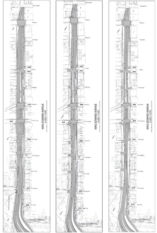
Three roadway configurations were considered for comparative purposes in this study. The two primary configurations consisted of a six-lane cross-section as per the recently completed construction work on King Edward Avenue, and a four-lane cross-section, as suggested by the community.
For evaluation purposes, the six-lane configuration was considered to be the “status quo” or baseline condition since it is the current configuration of King Edward Avenue. The four-lane configuration maintains two "through lanes" in both southbound and north bound directions with auxiliary turn lanes at key locations. Finally, a five-lane configuration was developed that combines aspects of the six-lane and the four-lane designs. All are described in more detail below and illustrated in Document 2.
It should be noted that the five-lane configuration is new to Phase 2 and was not originally one of the scenarios in the Phase 1 report. The five-lane configuration was developed through discussions with City Staff, members of the Task Force, and the consulting team.
Scenario 1: Six-Lane Configuration
The six-lane configuration includes three “through lanes” in the southbound direction with the curb lane (between Bruyère Street and York Street) being designated for “transit vehicles only” during the afternoon peak period and parking during all other periods. This configuration also includes double left turn lanes at Murray Street that extend back through the St. Patrick intersection, and shared through-right lanes at all intersections except Rideau Street where the third through lane becomes an exclusive right-turn lane. In the northbound direction, a third through lane is developed immediately north of Rideau Street and is carried through to St. Andrew Street at which point the curb lane is designated as a “right-turn only” lane to facilitate access into the neighbourhood and to prevent motorists from using the curb lane as a queue jump lane to gain faster access to the bridge.
Scenario 2: Five-Lane Configuration
On the west side of King Edward Avenue (southbound traffic direction) the configuration is identical to Scenario 1. On the east side of King Edward Avenue (northbound traffic direction) two “through lanes” are maintained in from Rideau Street to the MacDonald-Cartier Bridge ramp. An additional lane northbound to access Sussex Drive develops after the intersection at Cathcart Street.
Scenario 3: Four-Lane Configuration
The four-lane configuration maintains two “through lanes” in both southbound and northbound directions from Rideau Street to the MacDonald-Cartier Bridge ramp with auxiliary turn lanes at key locations (southbound double left turn lanes and southbound right turn lane at St. Patrick Street; a southbound right turn lane at Rideau Street; and a northbound lane to access the Sussex Drive ramp developing north of Cathcart Street; all other right turns are shared with a through lane).
Computer Modelling Overview
Phase 2 of the study included additional computer modelling to account for changes to the lane scenarios being assessed. Modelling was undertaken at both the corridor level (using VISSIM) and at the intersection level (using Synchro). Construction traffic volumes were used to reflect the conditions experienced during the King Edward Avenue reconstruction project, where the road was essentially operating as four-lanes.
Prior to construction, King Edward Avenue was operating as an unimpeded six lane arterial road and peak period traffic volumes were 40 to 45 per cent higher in the AM peak period and 15 per cent higher in the PM peak period than during construction.
As the reconstruction project nears completion and the street is back to six lanes, staff indicate that traffic volumes during the peak hour have returned, for the most part, to pre-construction levels. Traffic volume data monitored and collected from detector loops located on King Edward Avenue north and south of St. Andrew Street confirms the average counted traffic volume is 29 per cent higher in the southbound AM peak hour and 23 per cent higher in the PM peak hour than those used in the study.
As a result, staff believe that it is important to recognize that the modelling results discussed below understate the impacts and differences between scenarios and on the surrounding road network.
Corridor Level Modelling results (VISSIM)
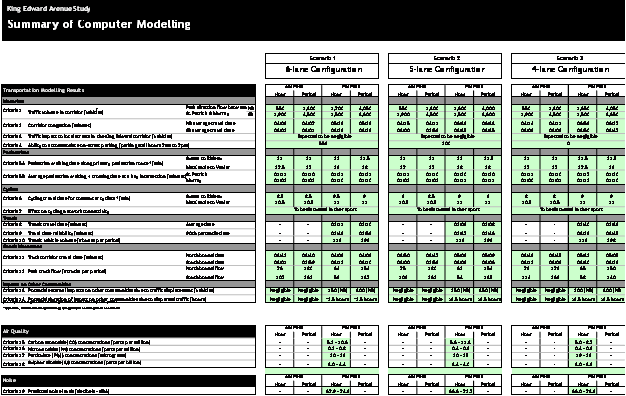
This section highlights the results of the Impact Analysis for each of the community and transportation criteria. A summary of these impacts for each lane reduction scenario is attached as Document 3.
Motorists - Results of the corridor level modelling demonstrate that, in the AM peak period, there is only a minor impact to vehicle travel times in the four-lane configuration. In the PM peak period, the modelling suggests that northbound automobiles will take up to 20 per cent longer to travel through the corridor in the five-lane configuration (+ one minute 10 seconds) and up to 27 per cent longer in the four-lane configuration (+ one minute 29 seconds).
Pedestrians - Pedestrian walking time along area corridors and waiting times to cross King Edward Avenue are not significantly affected by changes to the lane configuration. However, if longer cycle lengths are required over time to improve north/south traffic flow, then this could increase pedestrian waiting time at the intersections
Cyclists - The cycling results of the model mirror those of the pedestrian findings. Cycling time along area corridors are not significantly affected by changes to the lane configuration.
Transit - The modelling suggests that STO buses through King Edward Avenue are expected to experience a 22 per cent increase in average travel time (+29 seconds) and decreased reliability with the four-lane configuration.
Goods movement - In the PM peak period, the modelling suggests that northbound trucks will take up to 25 per cent longer to travel through the corridor in the five-lane configuration (+one minute six seconds) and up to 34 per cent longer in the four-lane configuration (+one minute 24 seconds). The volume of trucks able to pass through the corridor is not expected to change.
Safety considerations - Pedestrian exposure to traffic is reduced in both the five-lane and four‑lane configurations as crossing distances are shorter with fewer lanes. Similarly the modelling demonstrates an increase in vehicular travel time along King Edward Avenue for these scenarios. This can be interpreted as a reduction in average travel speed which has positive implications on safety.
Impacts on other communities - The modelling results using King Edward Avenue reconstruction volumes do not indicate a great variation in vehicles able to pass through the King Edward Avenue corridor between lane configurations. However, during the simulation, it was observed that constraints on King Edward Avenue caused extended queues to build up to the edge of the study area. This has the potential to increase congestion and infiltration into other neighbourhoods outside the study area.
While not modelled directly, staff indicate that traffic queues on King Edward Avenue routinely back up across both Rideau Street and the Mackenzie King Bridge, thereby blocking two major east-west transit corridors. This can have a significant adverse affect on both STO and OC Transpo operations. Additional congestion was also experienced on St. Patrick as west-bound queues often extended from King Edward Avenue to south of Beechwood Avenue on the Vanier Parkway, and on Sussex Drive in the vicinity of King Edward Avenue.
Overall, it is expected that the disturbance to the surrounding road network caused by the five‑lane and four-lane configurations may last longer than 2.5 hours whereas the potential disturbance caused by the six-lane configuration may last approximately 2.5 hours.
Intersection Level Modelling Results (Synchro)
The Phase 1 intersection level modelling remained valid through to Phase 2. As a result only the new scenario (the five-lane configuration) needed additional modelling efforts. This section highlights the results of the analysis based on intersection level of service (LoS) by scenario.
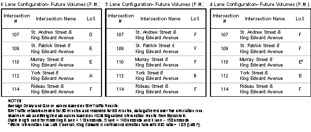
In general, the intersection level results support the findings of the corridor analysis which show that a reduction in lanes is expected to negatively affect the efficiency of vehicular movements through the intersections.
At a corridor level all scenarios perform more or less adequately during the AM peak hour (LoS E or better). However, in the PM peak hour, the six-lane configuration experiences difficulty processing the traffic at the intersection of Rideau Street and King Edward Avenue (LoS F). The remaining intersections in the corridor operate acceptably (LoS E or better). However, all intersections in the five-lane and four-lane configurations fail (LoS F) with the exception of York Street and King Edward Avenue (LoS B and E respectively), and Murray Street and King Edward Avenue (LoS E in the four-lane configuration).
Overall, the intersection level performance suggests that while most of the vehicles that were being accommodated when King Edward Avenue was under construction will still be able to travel through the corridor during peak periods in the five-lane and four-lane configurations, there will likely be reduced speeds, greater vehicle travel time, more bus travel time and less bus reliability.
Results of Public Consultation
Broader consultation was undertaken during this phase of the study to include other stakeholders beyond the Task Force and Lowertown community, which were the focus of phase 1. Other stakeholders consulted during phase 2 included adjacent neighbourhoods, transit operators, the goods movement industry, commuters and the public-at-large that had not yet been consulted.
Stakeholder Roundtables - Two roundtable-style discussions were held in October 2009. Attendance included representatives from the King Edward Avenue Task Force, Lowertown neighbourhood, adjacent neighbourhoods, and a variety of agencies. The feedback received echoed the concerns and issues that had been raised by the Task Force, such as traffic speed, noise, vibration, pollution, and lack of attractiveness in the corridor. Other feedback received during the roundtable sessions identified concerns or issues related to potential / perceived negative impacts to adjacent areas from a lane reduction, which included impacts to traffic back-ups on Dalhousie Street and into the Byward Market area. The impact on STO operations was also identified as a concern if it took longer for buses to get through the corridor.
Public Information Centre (PIC) - A PIC was held on March 4, 2010 with invitations extended to a wide range of stakeholder groups and agencies (including those previously invited to the roundtables). The event was also advertised in the local media. Attendance at the public information centre was predominantly from residents in the Lowertown neighbourhood. Feedback received was supportive of a lane reduction on King Edward Avenue and many participants expressed a preference for the four-lane scenario. Matters raised by participants during discussions included the potential for further disruption with additional reconstruction to implement the lane reduction and questions regarding the cost and timing of a lane reduction.
Evaluation of Lane Scenarios Relative to City's Vision for the Future
An important part of the Phase 2 evaluation was to assess how well each lane scenario fits with the city's vision for the future. To do this, each lane scenario was assessed relative to the policies of two existing plans and one current planning initiative:
• City of Ottawa Official Plan as amended by OPA #76 (existing)
• City of Ottawa Transportation Master Plan (existing)
• Choosing our Future Initiative and its end-state sustainability goals (currently underway)
Each lane scenario was assessed against the relevant policies of the three plans (see Document 3) using the following scale:
• Poor - the scenario does not support the policy or goes against it
• Acceptable - the scenario basically supports the municipality's direction
• Good - the scenario helps to advance the city towards the future
• Better - the scenario helps to advance the city towards the future by some degree further than just 'good'.
The following table summarizes the results of this assessment which shows that:
- The six-lane scenario basically supports municipal direction as it is an 'acceptable' fit with 33 policies. However, it is a 'poor' fit with 12 policies, and ranks the lowest in terms of 'good' and 'better' policies compared to the five-lane and four-lane scenarios.
- The five-lane scenario moves the city towards its vision for the future more than the six-lane scenario as it is a 'good' fit with 31 policies. It has an 'acceptable' fit with 17 policies and only a 'poor' fit with 2 policies.
- The four-lane scenario moves the city towards its vision for the future by a significant degree as it is a 'better' fit with 24 policies. It has a 'poor' fit with seven policies.
- No lane scenario fits perfectly when considered against the various policies. There are tradeoffs with each policy, particularly between those policies which speak to the efficiency of vehicular movement versus those policies address broader community benefits.
|
|
Official Plan |
Transportation Master Plan |
Sub Total |
Choosing our Future End-State Goals |
Total |
|
Six-Lane Scenario Poor Acceptable Good Better |
5 20 1 1 |
6 8 5 0 |
11 28 6 1 |
1 5 0 0 |
12 33 6 2 |
|
Five-Lane Scenario Poor Acceptable Good Better |
2 9 16 0 |
0 8 9 2 |
2 17 25 2 |
0 0 6 0 |
2 17 31 2 |
|
Four-Lane Scenario Poor Acceptable Good Better |
5 6 3 13 |
2 5 5 7 |
7 11 8 20 |
0 0 2 4 |
7 11 10 24 |
Overall, the evaluation determined that the four-lane scenario as an end state configuration is the best fit with the city we want for the future as articulated by the Official Plan, Transportation Master Plan and Choosing Our Future.
As has been previously discussed, the Choosing our Future initiative is currently underway and therefore has not yet been formally approved by Council. Even if the Choosing our Future goals are excluded from the assessment the results are not materially affected.
It should also be noted that the recommendation of the four-lane configuration is also consistent with the 2002 Environmental Assessment for King Edward Avenue, subject to various conditions being met.
Implementation Strategy to phase-in Four-Lane Configuration
While the four-lane scenario is seen to be the best fit with the city we want for the future, King Edward Avenue plays an important role as an interprovincial link for commuters and commercial traffic, and it is therefore important to consider the timing of implementation carefully.
The 2008 Transportation Master Plan as approved by Council provides recommendations on key road infrastructure projects including King Edward Avenue. The TMP indicates that a four-lane configuration is feasible under the following conditions: 1) construction of a suitably located east-end interprovincial crossing; 2) achieving a 43 per cent transit modal split across the Ottawa River screenline (compared to the current 25 per cent); and 3) removal of King Edward Avenue from the City's truck route network.
The Interprovincial Crossings Study is investigating future interprovincial crossings in the National Capital Region in terms of need, potential locations and options. To date, the study has determined that an additional end-end crossing is needed and has identified three corridors for further evaluated - Kettle Island (Corridor 5), Lower Duck Island (Corridor 6) and Gatineau Airport/McLaurin Bay (Corridor 7). Phase 2B, which will select an interprovincial bridge crossing in the Region’s east end is currently scheduled to be completed at the end of 2013, and the approvals process following completion of the Study is expected to extend to 2014.
Based on these conditions, an assessment of the various infrastructure and construction projects either underway currently or in the planning stage, and the results of the corridor- and intersection-level analysis, staff recommend that the four-lane cross-section be implemented only after the potential completion of a new Interprovincial Crossing.
King Edward Avenue as a Candidate Neighbourhood for the City's neighbourhood sustainability program (in development)
The Community Sustainability Department is developing a new neighbourhood sustainability program for the City of Ottawa, based on the 4-year Neighbourhood Planning Initiative (NPI) pilot program, a review of best practices, and the lessons learned from developing implementation strategies for the 2 NPI neighbourhoods during 2010. Program recommendations will be brought forward to Council in Q2 2011.
Given the complex range of issues that are affecting the King Edward Avenue area, and the existence of an active community association, staff will be identifying King Edward Avenue and its surrounding community for consideration as a candidate neighbourhood for the next phase of the City’s neighbourhood sustainability program.
RURAL IMPLICATIONS
There are no rural implications.
CONSULTATION
The King Edward Avenue Task Force as represented by Marc Aubin, Barbara Myers and Michel Vallée has been an integral part of the KEA Lane Reduction Study Team since the inception of the project. These community members have invested many hours of volunteer time to work with staff and the consultants to define the project and its analytical framework, and to review the outputs. While seeking consensus as much as possible throughout the study, there have been at times a number of hard conversations given the competing tension between King Edward Avenue as a road within the larger transportation network and as a road that serves the local community.
Broader consultation was also carried out with the community via two stakeholder roundtables in October 2009 and a public information centre in March 2010 as discussed in this report.
Councillor Mathieu Fleury, the Councillor for Ward 12 Rideau-Vanier, has also been consulted on this project.
COMMENTS BY THE PUBLIC WORKS DEPARTMENT
The Public Works Department has been consulted in the development of this report and is supportive of the report recommendation. Public Works will work with the Planning and Growth Management Department to implement the recommendation subject to approval from Council.
COMMENTS BY THE WARD COUNCILLOR(S)
Councillor Fleury agrees with the recommendation presented in this report. Although we would have hoped for a four lane implementation in the near future, given financial constraints and the current impact that it would have on our city transportation system, we will pursue different options to mitigate the challenges faced by our residents. It is important to acknowledge the important contributions made by both City staff and the community, including Michael Murr and the King Edward Avenue Task Force, in the process of the King Edward Avenue Lane Reduction Study.
LEGAL/RISK MANAGEMENT IMPLICATIONS
There are no legal/risk management implications associated with this report.
CITY STRATEGIC PLAN
This report is consistent with the City Strategic Plan's Transportation Priority and Planning and Growth Management Priorities.
TECHNICAL IMPLICATIONS
N/A
FINANCIAL IMPLICATIONS
Future-year funds will be required for detailed design and eventual reconstruction, and will be brought forward for Council consideration in the appropriate years’ Draft Budgets.
SUPPORTING DOCUMENTATION
Document 1 King Edward Avenue Lane Reduction Study - Phase 2 (on file with City Clerk)
Document 2 Lane Configuration Scenarios
Document 3 Summary of Community and Transportation Impact Analysis by Scenario
Document 4 Summary of Relevant Official Plan and Transportation Master Plan Policies, and Choosing our Future "End-State" Goals
DISPOSITION
Planning and Growth Management Department staff will bring forward for Council consideration in the appropriate years’ Draft Budgets an implementation strategy and costing for detailed design and eventual reconstruction.
Community Sustainability Department staff will identify King Edward Avenue and its surrounding community for consideration as a candidate neighbourhood in the next phase of the City’s neighbourhood sustainability planning program.
Lane Configuration Scenarios Document 2
Summary of Community and
Transportation Impact Analysis by Scenario DOCUMENT 3
Summary of Relevant Official Plan
and Transportation Master plan Policies
and CHoosing our Future “End-State” Goals DOCUMENT 4
|
Part A – Official Plan Policies |
|
|
Section Number |
Policy |
|
2.1 |
The Challenge Ahead Strategic Directions |
|
2.1 |
Providing Infrastructure: A transportation system that emphasizes transit, walking, and cycling will be built. |
|
2.1 |
Maintaining Environmental Integrity: Air quality will be supported by a transportation system that that emphasizes transit, walking, and cycling…
While transit, walking and cycling are mentioned, the emphasis is on air quality.
|
|
2.1 |
Creating Liveable Communities: Attention to design will help create attractive communities where buildings, open space, and transportation work well together. |
|
2.3.1 |
Providing Infrastructure Strategic Directions |
|
2.3.1(4) |
The City will minimize the effect of excessive traffic speed and volumes on residential neighbourhoods by researching and implementing measures and programs as part of its Area Traffic Management programs to enforce speed limits, discourage speeding, cut through traffic and reckless driving, and encourage walking, cycling and transit as preferred methods for trips in or through neighbourhoods.
Note: The Area Traffic Management program tries to improve traffic flow on the arterial road network as a means to reduce traffic infiltration into neighbourhoods. |
|
2.3.1(5) |
The City will implement a comprehensive Transportation System Management (TSM) program. TSM refers to strategies that can be implemented to make more efficient use of existing facilities through improved management and operation of transportation infrastructure. TSM focuses on optimizing existing infrastructure, for example, adjusting traffic control devices to maximize car flow, or to provide priority to transit vehicles. |
|
2.3.1(8) |
In the construction or reconstruction of transportation facilities, such as roadways, bridges, and transit stations, and public buildings, such as community centres and libraries, the City will ensure the provision of facilities to address the needs of pedestrians where feasible. |
|
2.3.1(14) |
In the construction or reconstruction of transportation facilities (roadways, bridges, transit stations, etc.) and public buildings (community centres, libraries, etc.), the City will ensure, to the extent possible, the provision of facilities to address the needs and safety of cyclists. |
|
2.3.1(19) |
The City will protect corridors for and develop the Primary and Supplementary Rapid-Transit Network and transit-priority network as shown on Schedule D…
|
|
2.3.1(22) |
The City will improve the speed and reliability of transit service by providing transit-priority measures to lessen delays on transit vehicles caused by other traffic and traffic control signals. Transit-priority measures will be implemented for those transit-priority corridors identified on Schedule D and at other opportune locations. |
|
2.3.1(28) |
The City will work with the City of Gatineau and the federal government to improve transit service between the Cities of Ottawa and Gatineau and investigate means to reduce or discontinue the use of King Edward Avenue and Rideau Street as bus waiting areas…
|
|
2.3.1(35) |
Priority use of lanes on a road or planned new lanes may be given exclusively to certain classes of roadway users if it contributes to the implementation of transportation and land-use objectives of this Plan. This may result in roadway lanes reserved for transit vehicles in identified locations supportive of rapid-transit and the transit-priority network. The City may give priority to lanes used for high occupancy vehicles on selected roads. Additional truck-priority lanes (e.g., Waller to Nicholas Streets) may also be implemented. |
|
2.3.1(36) |
The City will ensure that road corridors function as public spaces, while providing the necessary public infrastructure by implementing approved corridor or street design guidelines, including those for road classification types and for heritage districts, tourist areas and business improvement areas. It is recognized that the parkway network in the city, primarily developed by the National Capital Commission, contributes greatly to the distinct open space character of Ottawa. |
|
2.3.1(44a) |
To provide short-term parking that supports the vital interests of local businesses, institutions and tourism destinations; |
|
2.3.1(48) |
The City will minimize the impact of truck traffic on residential neighbourhoods caused by the presence of these vehicles and their noise, vibration and emissions by ensuring the availability of a comprehensive truck route network based on the arterial road system. |
|
2.3.1(49) |
The City will explore alternative means to accommodate interprovincial truck travel to minimize impacts on the Central Area, in particular along and in the vicinity of King Edward Avenue. After the potential completion of a new interprovincial corridor to accommodate trucks in a safe and efficient manner, the City will remove Rideau Street and King Edward Avenue from the City’s identified truck route system. (See also, policy 8 in Section 3.6.6 on the Central Area.) |
|
2.4 |
Maintaining Environmental Integrity Strategic Directions |
|
2(a) |
The City will reduce air emissions and GHG emissions resulting from the transportation sector by: Providing opportunities for the use of energy efficient transportation modes in order to minimize individual motor vehicle travel in favour of walking, cycling and transit. |
|
2.5 |
Building Liveable Communities – Design Principles |
|
2.5.1 |
To enhance the sense of community by creating and maintaining places with their own distinct identity. Design should: |
|
2.5.1.1 (2nd bullet) |
Recognize and reflect on the history of the city or community |
|
2.5.1.1 (4th bullet) |
Create distinctive places and appreciate local identity in patterns of development, landscape and culture |
|
2.5.1.1 (5th bullet) |
Reflect a thorough and sensitive understanding of place, context, and setting
|
|
2.5.1.2 |
To define quality public and private spaces through development... Design should: |
|
2.5.1.2 (3rd bullet) |
Consider streets as public spaces |
|
2.5.1.2 (6th bullet) |
Meet the needs of pedestrians as a priority |
|
2.5.1.2 (7th bullet) |
Contribute to attractive public spaces and important vistas
This interpretation relies on Policy 2.5.1.2 (3rd bullet) in which streets are considered as public spaces. |
|
2.5.1.2 (8th bullet) |
Minimize the exposure of inhabitants to noise levels that could adversely impact their health and well-being |
|
2.5.1.3 |
To create places that are safe, accessible and are easy to get to, and move through.... Design should: |
|
2.5.1.3 (4th bullet) |
Create places and spaces that are visible and safe and can be confidently used at all hours of the day and at night where it is appropriate to do so. |
|
2.5.1.7 |
To maximize energy-efficiency and promote sustainable design to reduce the resource consumption, energy use, and carbon footprint of the built environment.... Design should: |
|
2.5.1.7 (3rd bullet) |
Maximize opportunities for sustainable transportation modes (walking, cycling, transit facilities and connections).
This is urban design policy, not transportation policy; since transit on King Edward Avenue is not local, then transit is not considered relevant in this specific line of the evaluation. |
|
3.6 |
Urban Designations |
|
3.6.3 |
Mainstreets |
|
3.6.3(1) |
Traditional Mainstreets and Arterial Mainstreets are each designated on Schedule B. The former are planned as compact, mixed-use, pedestrian-oriented streets that provide for access by foot, cycle, transit and automobile… Both Traditional and Arterial Mainstreets will fulfill and take advantage of their multi-modal transportation corridor function…
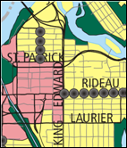
Schedule B from the Official Plan (before OPA #76) |
|
|
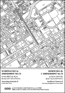
Schedule R42 to OPA #76 designating portions of King Edward Avenue as a “Traditional Main Street” |
|
3.6.3(8) |
Redevelopment and infill are encouraged on Traditional and Arterial Mainstreets in order to optimize the use of land through intensification, in a building format that encloses and defines the street edge and provides direct pedestrian access to the sidewalk… |
|
3.6.3(11) |
To achieve the vision for Mainstreets, changes within the public environment as well as within the abutting private property environment may be necessary. The function and design of a road may influence the nature of land use along it and changes to the street may be necessary in order to facilitate a more intense, pedestrian-oriented form of development adjacent to it. Where the City is proposing public works within a Mainstreet’s right-of-way, it will consider changes such as the institution of on-street parking, improvements to the pedestrian and cycling environment, streetscape enhancements, lane reductions and measures to enhance transit ridership in the area.
King Edward Avenue is not served by local transit so transit is not considered relevant in this specific line of the evaluation. |
|
3.6.6 |
Central Area |
|
3.6.6(2)(d) |
The City will support the Central Area’s role … by ensuring… public works have regard for the Central Area Secondary Plan policies to enhance the physical character, identity and unique heritage resources of the Central Area’s distinctive streets.
King Edward Avenue is identified as a distinctive street in Policy 3.6.6(7) (h). |
|
3.6.6(8)(c) |
To give walking, cycling and public transit priority in the Central Area: The City will, working with other levels of government, remove Rideau Street and King Edward Avenue from the City’s identified truck route system only after the potential completion of a new inter provincial corridor to accommodate trucks; |
|
Part B – Transportation Master Plan Policies |
|
|
Section Number |
Policy |
|
3.1 |
Ottawa’s Transportation Vision |
|
Element 1 Principle (a) |
Give priority to public transit in meeting future growth in travel demand |
|
Element 1 Principle (b) |
Make walking and cycling more attractive than driving for short trips |
|
Element 2 Principle (a) |
Provide a continuous, integrated system of multimodal facilities and services [to meet mobility needs] |
|
Element 2 Principle (b) |
Aim to provide an acceptable standard of service for each mode of travel
Evaluation is based on northbound p.m. peak period modelling results. |
|
Element 2 Principle (c) |
Give priority to public transit, walking and cycling over cars when conflicts arise |
|
Element 3 Principle (a) |
Build walkable communities |
|
Element 3 Principle (b) |
Provide rapid transit and other quality transit services to community cores and employment areas |
|
Element 3 Principle (e) |
Foster a vibrant downtown by improving transit, walking and cycling access |
|
Element 4 Principle (a) |
Give priority to safety and security when planning, designing and operating transportation systems |
|
Element 4 Principle (d) |
Minimize the impacts of truck and automobile traffic on sensitive communities |
|
Element 4 Principle (e) |
Minimize air pollution from transportation sources |
|
Element 5 Principle (b) |
Minimize transportation energy use, greenhouse gas emissions and other impacts on air, water, and land |
|
Element 5 Principle (c) |
Maximize greening within transportation rights of way |
|
Element 6 Principle (b) |
Support efficient freight movement to, from and within the city |
|
Element 7 Principle (a) |
Make the best possible use of existing facilities before adding new infrastructure [to deliver cost-effective services]
In the context of King Edward Avenue, the new infrastructure potentially possible by the lane configurations includes wider sidewalks and/or dedicated cycling lanes. |
|
3.4 |
Managing the Transportation System |
|
1) |
The City will endeavour to maintain a maximum 90 per cent volume-to-capacity ratio for mixed traffic at signalized intersections during weekday peak hours, where feasible, except in the Central Area where a 100 per cent ratio will be acceptable. Supporting initiatives will give due consideration to City objectives for road safety and improvements to conditions for walking, cycling and transit. |
|
6.4 |
Roads |
|
1) |
The City will apply design guidelines for new, widened and reconstructed roads...
Reference is made to the City’s “Urban Design Guidelines for Development Along Traditional Main Streets” in the interpretation of this policy. |
|
2) |
The City will consider measures such as on-street parking, walking and cycling improvements, streetscaping, lane reductions or transit enhancements for roads identified as mainstreets or collectors in the Official Plan, particularly in Town Centres and Mixed-Use Centres.
King Edward Avenue is not served by local transit so transit is not considered relevant in this specific line of the evaluation. |
|
6.11 |
Parking |
|
4a) |
The City will support the availability of short-term parking for business (retail and service), institutional, residential and tourism uses, particularly those in the Central Area and inner city neighbourhoods, by providing on-street parking that does not compromise multimodal safety or service level targets |
|
Part C – Draft End State Goals from “Choosing Our Future” |
|
|
End-State Goal |
Description |
|
Health and Quality of Life |
Goal: All residents enjoy a high quality of life and contribute to community well-being Our communities are healthy, safe, secure, accessible, and inclusive places, where all residents have the opportunities required to enjoy a high quality of life and be involved in community life.
Indirect: The street’s configuration may relate to citizen’s perceptions of safety and accessibility. |
|
Economic Prosperity |
Goal: Economic prosperity supports residents, community well-being, and ecological health Wealth is generated with a fraction of today’s material and energy throughput and with respect for the limits of planetary ecosystems and resources. The region’s economy supports regional self-reliance, good jobs for local people, and contributes to a high quality-of-life for all residents. Residents and businesses also support responsibly-produced goods and services from around the world.
Not applicable. While there could be an opportunity to stimulate redevelopment with a road reconfiguration, an economic relationship is difficult to quantify for the lane configurations. |
|
Culture and Identity |
Goal: Cultural vitality and diversity contribute to the region’s strong identity Ethnic diversity, artistic expression, and distinctive cultural heritage are supported and valued, contributing to a strong sense of place, identity, inclusivity and meaning. The culture of the region reflects a strong ethic of community and sustainability.
Direct: The former configuration of King Edward as a local street has some relationship to the area’s cultural heritage. |
|
Biodiversity and Ecosystem Health |
Goal: Ecosystems are healthy, protected and support biodiversity The region continues to fulfill its traditional ecological functions, supporting connected habitats, regulating water and nutrient cycles, and providing food and shelter to all species living in the region. Residents value biodiversity and ecosystem health and understand the interconnectedness between humans, other species, and the ecosystems in which we all live.
Not applicable. The lane configurations do not impact ecological functions (e.g., water cycle) which are predominantly addressed through urban engineered systems within the study area. |
|
Governance and Decision-Making |
Goal: Decision-making is open, informed and inclusive All voices in the region are heard, and each resident has the opportunity to collaborate and help set shared directions that are open, informed, and characterized by accountability and equity. As a region we can make decisions effectively and efficiently while fostering a shared sense of ownership and pride in our collective sustainability journey. We are a model for other regions and we share our knowledge openly in the hope that others will learn from our progress.
Not applicable. The lane configurations do not impact the ability of citizens to participate in decision making. |
|
Climate Change |
Goal: The region is carbon neutral and adapts to a changing climate The region is carbon neutral in that greenhouse emissions are reduced to the point where they can be absorbed (sequestered) by its ecosystems and technologies. The region has also ensured that it can adapt to deal with the impacts of climate change.
Direct: Air quality has been modelled for the scenarios. |
|
Energy |
Goal: Energy is used efficiently and supplied from green, renewable sources Energy is used efficiently and responsibly in the region and comes from a diverse portfolio of resources that are renewable, low-impact, and contribute to local economic development. The region also manages demand for energy through community planning, transportation initiatives, and building design.
Indirect: A street configuration that is conductive to walking and cycling provides local transportation alternatives to the private automobile. |
|
Connectivity and Mobility |
Goal: Walking, cycling, and transit are residents’ first choices for transportation Through careful land use planning, the need to travel long distances has been greatly reduced because jobs and most of our daily needs are provided in complete, livable communities. Transportation networks are well-connected between and within communities, minimizing environmental impacts, moving people and goods safely, efficiently, and affordably, and encouraging social interaction. Residents choose walking, cycling and transit and mobility is enhanced by electronic communications, good planning and urban design.
Direct: Walking, cycling, and transit have been analyzed for the scenarios. |
|
Materials and Solid Waste |
Goal: Waste is reduced towards zero Waste is reduced to the point where it can be managed in the region without compromising human and ecological health. The use of virgin materials is greatly reduced because waste is used as a resource (recycled) wherever possible.
Not applicable. The lane configurations do not impact solid waste generation. |
|
Water and Wastewater |
Goal: Water resources are cherished, conserved and protected Regional water demand and management is consistent with the region’s available water resources and meets the needs of ecological systems and other species. Wastewater and pollution are managed effectively so that the region’s water supports natural aquatic ecosystems as well as our needs for fresh drinking water.
Not applicable. The lane configurations do not impact regional water resources. |
|
Housing |
Goal: Housing options are green, healthy and meet the needs of the whole community A variety of housing options provide affordable, attractive and accessible choices for all the people within the region. This range of housing choices exists within every community and allows people of various abilities and incomes to live in a community throughout various life stages. Housing is energy-efficient, healthy, and attractive, and uses sustainable building materials and practices.
Indirect. The lane configuration may impact citizen’s perspectives on the attractiveness of housing in the study area. |
|
Food and Agriculture |
Goal: The local food system is sustainable and provides residents with healthy and affordable food The region’s farmers, working on a well-protected, highly productive land base, produce a great variety of foods using diverse, sustainable practices. While residents consume food from outside the region as well as modest amounts from urban areas, the region’s farms and the local food system provide residents and businesses with a high-quality, healthy, and affordable supply of food.
Not applicable. The lane configurations do not impact food production or agriculture. |