3. ZONING – 1024 and 1026 Old MontrÉal
Road
(FILE NO. d02-02-10-0062)
ZONAGE – 1024 et 1026, chemin
old montrÉal
COMMITTEE
RECOMMENDATION
(This matter is
Subject to Bill 51)
That Council
approve an amendment to the Zoning By-law 2008-250 to change the zoning of 1024
and 1026 Old Montreal Road from DR (Development Reserve) to R4Z [XXXX]
(Residential Fourth Density Subzone Z Exception), O1 [XXXY] (Parks and Open
Space Exception) and EP (Environment Protection Zone) and from EP
(Environmental Protection) to R4Z [XXXX] (Residential Fourth Density Subzone Z
Exception) and O1 [XXXY] (Parks and Open Space Exception) as shown in Document
2 and as detailed in Document 3.
RECOMMANDATION DU COMITÉ
(Cette question est assujettie au Règlement 51)
Que le Conseil approuve une modification du
Règlement municipal de zonage 2008‑250 afin de changer la désignation de
zonage des 1024 et 1026 du Vieux chemin de Montréal de DR (Zone d’aménagement
futur) à R4Z [XXXX] (Zone résidentielle de densité 4,
sous-zone Z, avec exception), à O1
[XXXY] (Zone de parc et d'espace vert, avec exception) et à EP (Zone de protection de
l’environnement) et de EP (Zone de protection de l’environnement) à R4Z [XXXX]
(Zone résidentielle de densité 4, sous-zone Z, avec exception) et à O1 [XXXY] (Zone de parc et
d'espace vert, avec exception), tel
qu'il est indiqué dans le document 2 et décrit en détail dans le document 3.
Documentation
1.
Deputy
City Manager's report, Infrastructure
Services and Community Sustainability, dated 20 June 2011 (ACS2011-ICS-PGM-0091).
Report to/Rapport au :
Comité
de l'urbanisme
and Council / et au Conseil
20 June 2011 / le 20 juin2011
Submitted by/Soumis par :
Nancy Schepers, Deputy City Manager/Directrice
municipale adjointe, Infrastructure Services
and Community Sustainability/Services d’infrastructure et Viabilité des
collectivités
Contact
Person/Personne-ressource : Derrick Moodie, Acting Manager/Gestionnaire
intérimaire, Development Review-Suburban Services/Examen des projets
d'aménagement-Services suburbains, Planning and Growth Management/Urbanisme et
Gestion de la croissance
(613)
580-2424, 15134 Derrick.Moodie@ottawa.ca
|
SUBJECT: |
ZONING
– 1024 and 1026 Old MontrÉal Road (FILE NO. d02-02-10-0062) |
|
|
|
|
OBJET : |
REPORT RECOMMENDATION
That the Planning Committee
recommend Council approve an amendment to the Zoning By-law 2008-250 to change
the zoning of 1024 and 1026 Old Montreal Road from DR (Development Reserve) to
R4Z [XXXX] (Residential Fourth Density Subzone Z Exception), O1 [XXXY] (Parks
and Open Space Exception) and EP (Environment Protection Zone) and from EP
(Environmental Protection) to R4Z [XXXX] (Residential Fourth Density Subzone Z
Exception) and O1 [XXXY] (Parks and Open Space Exception) as shown in Document 2
and as detailed in Document 3.
RECOMMANDATIONSDU
RAPPORT
Que le Comité de l'urbanisme
recommande au Conseil d'approuver une modification du Règlement municipal de zonage 2008‑250
afin de changer la désignation de zonage des 1024 et 1026 du Vieux chemin de
Montréal de DR (Zone d’aménagement futur) à R4Z [XXXX] (Zone résidentielle de densité 4, sous-zone Z, avec exception), à O1 [XXXY] (Zone de parc et
d'espace vert, avec exception) et à EP
(Zone de protection de l’environnement) et de EP (Zone de protection de
l’environnement) à R4Z [XXXX] (Zone résidentielle de densité 4,
sous-zone Z, avec exception) et à O1
[XXXY] (Zone de parc et d'espace vert, avec exception), tel qu'il est indiqué dans le
document 2 et décrit en détail dans le document 3.
BACKGROUND
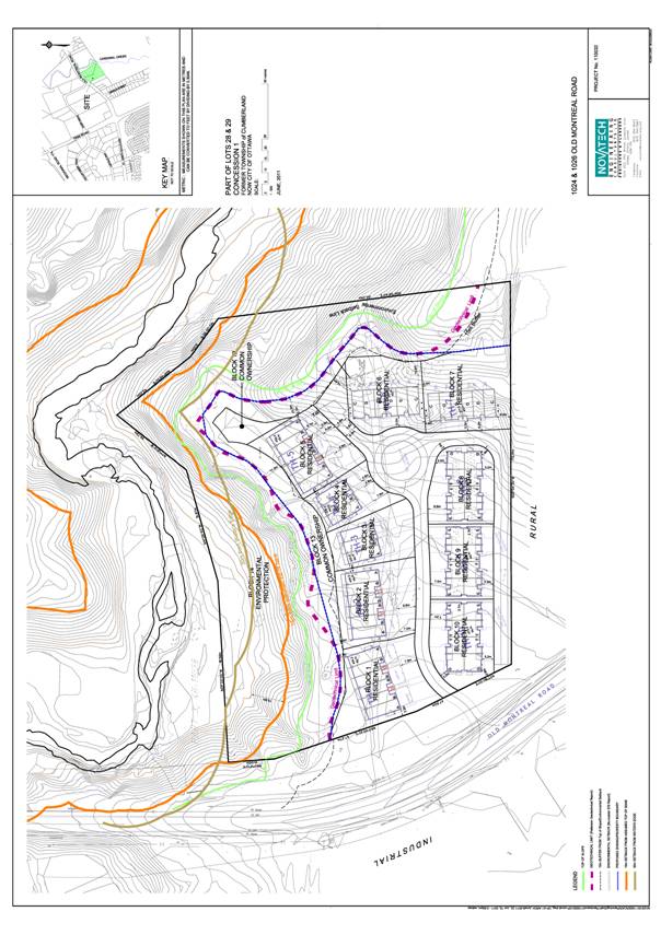
The subject property is located on the south side of Old Montreal Road, approximately 450 metres east of Trim Road as shown in Document 1. The site is irregularly shaped with an approximate area of 2.7 hectares. The site is bounded by Cardinal Creek to the east and south, which is also the limit of the urban boundary. To the west is a mixture of low density residential, and rural type land uses. The Taylor Creek Business Park, an Employment Area, is situated on the north side of Old Montreal Road across from the subject site. The closest industrial use is Healthcare Food Services situated approximately 125 metres to the north west on Dairy Road. The Business Park also contains a Park and Ride and OC Transpo.
The site currently contains two vacant detached residential dwellings, which are to be removed. The site also houses a dog kennel that has not been in operation for a number of years. The majority of the topography of the site is relatively flat except for the eastern limit that forms the steep sided ravine to Cardinal Creek and the southern limit of the site that climbs to a knoll overlooking the wooded ravine of Cardinal Creek. Cardinal Creek Valley is designated as an Urban Natural Feature in the Official Plan.
Purpose of Zoning Amendment
The proposal would rezone the lands to establish a residential zone that permits a variety of residential uses including multiple attached dwelling, stacked townhouse dwelling, low-rise apartment, and planned unit development. The applicant is proposing a 60‑unit planned unit development consisting of 24 back-to-back multiple attached units and 36 loft-style multiple attached units on a private street. The proposed Zoning By-law amendment will also refine the limits of the environmental protection zone in accordance with the Environmental Impact Study and geotechnical investigation.
Existing Zoning
The subject site is currently zoned DR (Development Reserve) and EP (Environmental Protection). The DR zone only permits limited uses and existing uses in anticipation of future urban redevelopment. The intent of the EP zone is to recognize lands that are designated in the Official Plan as Significant Wetlands, Natural Environment Areas or Urban Natural Features. The EP zone only permits uses that are compatible with and assist in the protection of the environmental attributes of these lands, or are in keeping with applicable Official Plan policies.
Proposed Zoning
The requested zoning is a R4Z[XXXX] - Residential Fourth Density Subzone Z Exception XXXX with a site specific exception and O1 [XXXY] – Open Space Exception zone for the common use environmental buffer and amenity areas. The amendment will also rezone a small portion of the land from DR to EP – Environmental Protection.
DISCUSSION
Official Plan
The Official Plan designates the subject lands General Urban Area and Urban Natural Features. The General Urban Area designation permits the development of a full range and choice of housing types. The proposal is in keeping with the policies of the plan and will assist the City in achieving its overall intensification and housing objectives. The proposed development will occupy an under-developed parcel of land within the urban area with a medium density residential development. This is appropriate given the site’s location adjacent to a developing employment area, Highway 174 and a Park and Ride facility. The development minimizes land consumption and maximises the use of existing infrastructure.
The proposed development conforms to Official Plan policies with respect to compatibility and community design. The proposed multiple attached housing form will enhance the ‘established community’ and ‘coexist with existing development’. The proposed building heights, mass and street setback are consistent with other multiple attached dwellings found in the developing residential communities to the west and south of the site. The massing and layout of the proposed units adjacent to the creek valley and the development’s orientation to Old Montreal Road fits well within the site’s physical context and works well among the functions that surround it.
The draft plan of subdivision contains a series of residential blocks which all front on a private road. The private road is designed to align with the planned extension of Dairy Drive to Old Montreal Road. The plan also contains common ownership blocks for environmental protection and amenity space purposes.
The applicant has also applied for Site Plan Control approval and Draft Plan of Subdivision which are detailed processes to further refine the design of the site and buildings. Technical studies such as servicing, traffic, environmental and geotechnical have also been submitted in support of the applications, including the Zoning By-law Amendment application. The Transportation Brief concluded that the proposed access will operate well within capacity and with acceptable levels of service under all traffic conditions.
Details of Proposed Zoning
The majority of the site will be zoned R4Z[XXXX] which will include all of the provisions of the R4Z zone with exceptions to the front yard, rear yard and interior yard setbacks. The front yard setback would be 2.5 metres rather than 3.0 metres. The interior side yard setback would be 4.0 metres and the rear yard setback would be 7.0 metres, instead of having a varying setback for these particular provisions as required by the Zoning By-law. A minimum density of 21.0 units per hectare is being applied to the site to ensure a medium density residential product is developed as proposed.
As Cardinal Creek and its associated valley is designated Urban Natural Feature and the proposed development is within 30 metres of the boundary of the Urban Natural Feature, an Environmental Impact Study (EIS) was required.
The EIS found that the significant natural environmental features of the adjacent creek valley will not be directly impacted by the proposed development. Additionally, along the easterly side of property, a 15‑metre setback is proposed from the edge of the Urban Natural Area and the limit of development. Approximately 10 metres of this buffer located closest to the top-of-bank will continue to be zoned EP and will be allowed to naturalise. The five metre portion closest to the proposed buildings will be zoned O1[XXXY] and used as a passive, environmentally friendly rear yard amenity area. No buildings including sheds, swimming pools or play structures will be permitted in this area. There will also be a five‑metre setback to the natural features in the southwest corner of the site.
Given the site’s location adjacent to a river valley, a geotechnical investigation and slope analysis was completed for the proposed development. As a result, a geotechnical limit of hazard lands setback line has been defined along the top of slope in the east and south portions of the site. This limit of hazard lands is within the previously discussed 15‑metre environmental setback from the top of slope, and since all buildings will be entirely outside the 15‑metre setback, all future development will be protected from any potential erosion hazards.
Staff recommend approval of the Zoning By-law amendment as the proposed residential development complies with the Official Plan and is consistent with existing development in the area. Furthermore, it will result in a built form that meets key intensification policies of the Official Plan, while at the same time provides a compatible residential development.
RURAL IMPLICATIONS
N/A
CONSULTATION
Notice of this application was carried out in accordance with the City's Public Notification and Consultation Policy. Information on the consultation process is outlined in Document 3.
COMMENTS BY THE WARD COUNCILLOR(S)
The Ward Councillor is aware of this application and the staff recommendation.
LEGAL IMPLICATIONS
There are no legal
implications associated with this report.
RISK MANAGEMENT IMPLICATIONS
There are no risk management implications associated with this report.
FINANCIAL IMPLICATIONS
There are no direct financial implications associated
with this report.
ENVIRONMENTAL
IMPLICATIONS
The site being adjacent to an Urban Natural Feature and river valley required the completion of an Environmental Impact Statement and geotechnical investigation and slope stability analysis. These studies have been completed and approved by the City and all study recommendations have or will be implemented and will be further incorporated into conditions of approval for the Plan of Subdivision and Site Plan Control applications.
TECHNOLOGY IMPLICATIONS
CITY STRATEGIC PLAN
The application is consistent with the Planning and Growth Management priority which encourages the infill and intensification of lands designated General Urban Area.
APPLICATION PROCESS TIMELINE STATUS
The application was not processed by the "On Time Decision Date" established for the processing of Zoning By-law amendments due to complexity of issues associated with the geotechnical investigation and environmental concerns.
SUPPORTING DOCUMENTATION
Document 1 Location Map
Document 2 Zoning Key Plan
Document 3 Details of Recommended Zoning
Document 4 Consultation Details
Document 5 Concept Plan
DISPOSITION
City Clerk and Solicitor Department, Legislative Services to notify the owner, applicant, OttawaScene Canada Signs, 1565 Chatelain Avenue, Ottawa, ON K1Z 8B5, Ghislain Lamarche, Program Manager, Assessment, Financial Services Branch (Mail Code: 26-76) of City Council’s decision.
Planning and Growth Management to prepare the implementing by-law, forward to Legal Services and undertake the statutory notification.
Legal Services to forward the implementing by-law to City Council.
LOCATION MAP DOCUMENT
1
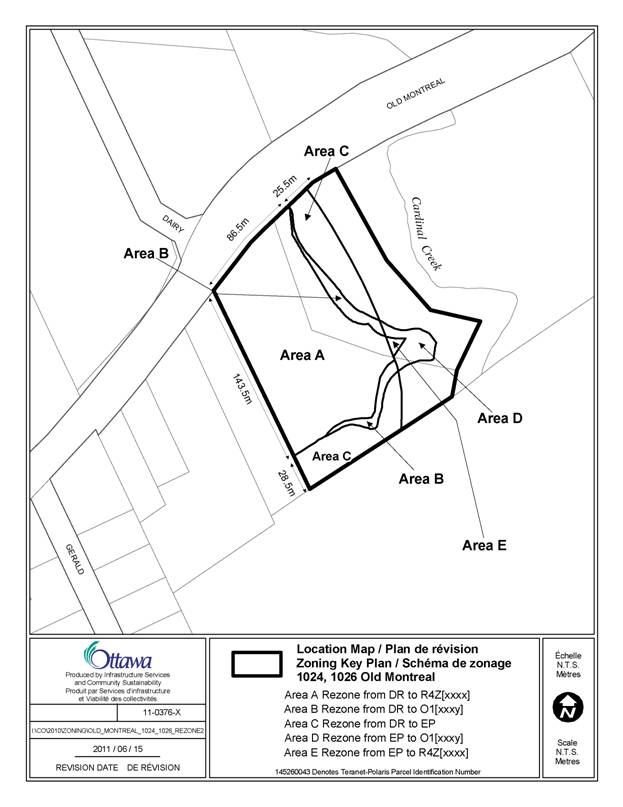
ZONING KEY MAP DOCUMENT
2
DETAILS OF RECOMMENDED ZONING DOCUMENT 3
1.
Rezone the subject lands shown on Document 1 as
follows:
a.
Area A from DR to R4Z[XXXX];
b.
Area B from DR to O1[XXXY];
c.
Area C from DR to EP;
d.
Area D from EP to O1[XXXY] and,
e.
Area E from EP to R4Z[XXXX]
2.
Add a new exception, R4Z[XXXX], to Section 239 with
provisions similar in effect to the following:
(i)
In Column II the text “R4Z[XXXX] ”
(ii)
In Column IV –Detached, Linked-detached,
Semi-detached, Duplex
(iii)
In Column V:
“- minimum density is 21 units per hectare
- the lands zoned R4Z[XXXX] and O1[XXXY] are
to be considered one lot for zoning purposes
- minimum front yard setback: 2.5 m
- minimum rear yard setback: 7 m
- minimum interior side yard setback: 4 m”
3.
Add a new exception, O1[XXXY], to Section 239 with
provisions similar in effect to the following:
(i)
In Column II the text “O1[XXXY]”
(ii)
In Column V:
“ - the lands zoned R4Z[XXXX] and
O1[XXXY] are to be considered one lot for zoning purposes
-
no buildings,
decks, sheds, garages, workshops, septic systems, wells, play structures,
swimming pools, change houses, pump houses are permitted within the O1[XXXY]
zone.”
CONSULTATION DETAILS DOCUMENT
4
NOTIFICATION AND CONSULTATION PROCESS
Notification and public consultation was undertaken in accordance with the Public Notification and Public Consultation Policy approved by City Council for Zoning By-law amendments.
SUMMARY OF PUBLIC INPUT
1. A letter of opposition was received from Healthcare Food Services of an existing industrial use at 1010 Dairy Road, which is located approximately 125 metres to the south west in the Taylor Creek Business Park. They oppose the development for two reasons. As they are involved in the production of food, they believe by allowing residential uses close to their manufacturing plant it will create the risk of the new residents lodging noise, traffic and environmental complaints and blocking future expansions of the plant. The second reason stated is that by allowing residential development it “further erodes the City’s ability to create a vibrant employment base for Orleans that is friendly to industrial and commercial employers.”
Staff Response:
The subject lands are designated General Urban Area which permits residential uses and given the existing land use pattern of residential uses along the south side of Old Montreal Road, it was determined that a residential use is the most appropriate use for the subject property.
Further, staff is not aware of any existing problems due to noise and smell that have been experienced by existing residents in the area due to the plant, and it is not anticipated that there will be any negative impact to future residents living on the subject property. However, this will be investigated further through the Site Plan Control approval process and if warranted, warning clauses can be registered on title as a condition of Site Plan Control approval warning of possible noise and smells at times from the adjacent food manufacturing plant.
2. A comment was received from an existing resident who identified concerns with the proposed apartment building, traffic, noise and potential impact on surrounding existing wells.
Staff Response:
The applicant is no longer proposing the construction of an apartment building; however, the proposed R4Z zoning being recommended for the site will still permit a low rise apartment building up to four stories. This is appropriate given that should market demand change and an apartment building is constructed, it would be an acceptable housing form as it would not have any negative impact on adjacent existing uses and it allows for flexibility to have the opportunity to construct a variety of housing types, meeting an important objective of the Official Plan.
The applicant has been requested to complete a Well Impact Study and any recommendations from that study will be incorporated into conditions of approval of the Draft Plan of Subdivision application.
COMMUNITY ORGANIZATION COMMENTS
Comments were received from the Cardinal Creek Community Association who expressed concerns with potential environmental impacts on Cardinal Creek and increased traffic.
Staff Response:
The subject lands are currently zoned DR- Development Reserve which recognizes lands intended for future urban development in areas designated General Urban Area in the Official Plan. A Traffic Brief was completed which has been reviewed and accepted by staff and indicates that the proposed development can be accommodated by the local transportation network and the proposed access will operate well within capacity and with acceptable levels of service under total traffic conditions.
ADVISORY COMMITTEE COMMENTS
The Ottawa Forests and Greenspace and Advisory Committee (OFGAC) reviewed the EIS and commented that the proposed development should not impact the Cardinal Creek Valley Urban Natural Area and that there should be a clear identification of the boundaries of the forested area and constant monitoring of the site during construction to ensure that there is no impact on Cardinal Creek UNA. The Committee is also concerned that the future viability for the City to create the continuation of the pathways and linkages along the Cardinal Creek Valley corridor will be compromised.
Staff Response:
The proposed Zoning By-law amendment will implement a 15-metre environmental setback from the Cardinal Creek Valley UNA. The recommendations from the Environment Impact Statement (EIS) will be implemented which will ensure the trees and vegetation along the boundary of the UNA will be protected. The applicant will be required to follow any tree conservation recommendations contained in the EIS and a tree permit under the Urban Tree Conservation By-law 2009-200 will be required prior to any tree removal. The EIS recommendations regarding protection of adjacent natural areas during construction will be closely followed and on-site monitoring of site construction will occur by City staff.
A proposed “Major Recreational Pathway” is identified on Schedule I of the Official Plan to be built somewhere along the Cardinal Creek Valley. The system shown on the Schedule is conceptual and staff did consider the potential to locate a portion of this future public pathway on the subject lands. Consideration was given to locating the pathway in the 10. 0 metre portion of the buffer zoned EP, which is located closest to the top of slope. Notwithstanding that this area is still owned by the applicant, staff will continue to explore the feasibility of constructing a pathway somewhere along the valley corridor.
CONCEPT PLAN DOCUMENT 5