|
3.
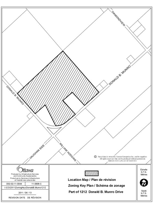
Zoning – Part of 1212 Donald B. Munro Drive ZONAGE - partie du 1212,
promenade donald b. munro |
COMMITTEE
RECOMMENDATION
That Council approve an amendment to Zoning By-law 2008-250 to
change the zoning of part of 1212 Donald B. Munro Drive from AG (Agricultural)
to AG5 (Agricultural, Subzone 5), as shown in Document 1.
RECOMMANDATION DU COMITÉ
Que le Conseil approuve une
modification au Règlement de zonage 2008-250 pour faire passer le zonage d’une
partie du 1212, promenade Donald-B.-Munro Drive de Zone agricole (AG) à
Sous-zone agricole 5 (AG5), comme le montre le document 1.
Documentation
1. Deputy City Manager’s Report, Infrastructure
Services and Community Sustainability, dated 25 July 2011 (ACS2011-ICS-PGM-0151).
Report to/Rapport au :
Agriculture and Rural Affairs Committee
Comité de l'agriculture et des
affaires rurales
and Council / et au Conseil
25 July 2011 / le 25 juillet 2011
Submitted by/Soumis par :
Nancy Schepers, Deputy City Manager/Directrice
municipale adjointe, Infrastructure Services
and Community Sustainability/Services d’infrastructure et Viabilité des
collectivités
Contact
Person/Personne-ressource : Derrick Moodie, Manager/Gestionnaire, Development
Review-Rural Services/Examen des projets d'aménagement-Services ruraux,
Planning and Growth Management/Urbanisme et Gestion de la croissance
(613)
580-2424, 15134 Derrick.Moodie@ottawa.ca
|
SUBJECT: |
ZONING – Part of 1212
Donald b. Munro drive (FILE NO. D02-02-11-0044) |
|
|
|
|
OBJET : |
REPORT RECOMMENDATION
That the Agriculture
and Rural Affairs Committee recommend Council approve an amendment to Zoning
By-law 2008-250 to change the zoning of part of 1212 Donald B. Munro Drive from
AG (Agricultural) to AG5 (Agricultural, Subzone 5), as shown in Document 1.
RECOMMANDATION
DU RAPPORT
Que le Comité de l’agriculture et des affaires
rurales recommande au Conseil
d’approuver une modification au Règlement de zonage 2008-250 pour faire passer
le zonage d’une partie du 1212, promenade Donald-B.-Munro Drive de Zone
agricole (AG) à Sous-zone agricole 5 (AG5), comme le montre le document 1.
BACKGROUND
The subject
land, 1212 Donald B. Munro Drive, is located on the north side of Donald B. Munro Drive and
east of the intersection with William Hodgins Lane. It
is an agricultural parcel, surrounded by agricultural uses to the north, south,
east and west. The subject land has a
frontage of 522.5 metres along Donald B. Munro Drive and an area of
approximately 38.32 hectares.
This parcel was the subject of a recent consent application. The existing dwelling and associated
outbuildings are being severed as a surplus farm dwelling. The retained land will remain vacant and will
continue to be used for agricultural purposes.
Purpose of Zoning Amendment
The proposal is to rezone part of the subject land to meet a condition of consent to sever a surplus farm dwelling imposed by the Committee of Adjustment (Application No. D08‑01‑11/B‑00024).
The land to be severed will have a frontage of 140 metres on Donald B. Munro Drive and contain a lot area of 2.7 hectares. It will contain a detached dwelling, barn, workshop and two sheds.
The land to be retained, which is the subject of the zoning request, will have a broken frontage totalling 382.5 metres on Donald B. Munro Drive and contain a lot area of 35.61 hectares.
Existing Zoning
The subject land is currently zoned Agricultural (AG). This zoning recognizes and permits agricultural uses on a minimum lot area of 90 hectares in areas designated Agricultural Resource Area in the Official Plan and restricts the range of permitted uses to agricultural, forestry and related uses in order to preserve prime agricultural lands from loss to other uses.
Proposed Zoning
The requested zoning amendment proposes to rezone the retained parcel (farmland) from AG to Agricultural Subzone 5 (AG5). This zoning permits agricultural uses, but prohibits residential uses. This particular subzone represents agricultural lands with a minimum area of 30 hectares and a minimum frontage of 60 metres.
DISCUSSION
Official Plan
According to the Official Plan, the subject land is designated Agricultural Resource Area. This designation protects prime agricultural areas from loss of lands to other uses. The policies ensure that a severance for the creation of a new lot on which is located a dwelling made surplus through farm consolidation does not permit the construction of a new dwelling on the lot rendered vacant through the severance. The policies require that the vacant agricultural parcel so created be rezoned to prohibit any residential uses. The housing restriction is intended to limit a pattern of lot creation in Agricultural Resource Areas that would see a new residence being constructed on the vacant farm property, the house being declared surplus and severed for a lot, and the pattern so continued.
Zoning By-law
The site is zoned Agricultural (AG). The AG zone permits a detached dwelling, agricultural use and several other uses. In order to ensure that the intent of the Official Plan policies is implemented in the Zoning By-law, it is recommended that the zoning of a portion of the subject land (retained farmland) be changed from Agriculture (AG) to Agricultural Subzone 5 (AG5), as shown on Document 1. The AG5 zone will prohibit residential uses on a lot having a minimum area of 30 hectares and a minimum lot width of 60 metres. This rezoning is considered appropriate since it will protect agricultural land from loss to other uses and the lot will continue to respect the minimum lot area and width requirements.
RURAL IMPLICATIONS
The subject land will be limited to agricultural uses. By restricting residential uses, major agricultural areas will be protected from fragmentation and competing uses. The effect of this rezoning will be to enhance the rural heritage and fortify the rural landscape.
CONSULTATION
Notice of this application was carried out in accordance with the City's Public Notification and Consultation Policy. The City did not receive any negative comments or opposition to this application.
COMMENTS BY
THE WARD COUNCILLOR(S)
The Ward Councillor is aware of this application and the staff recommendation.
LEGAL/RISK
MANAGEMENT IMPLICATIONS
There are no legal/risk management implications associated with this report.
N/A
TECHNICAL IMPLICATIONS
N/A
FINANCIAL IMPLICATIONS
There are no direct financial implications associated with this report.
APPLICATION
PROCESS TIMELINE STATUS
This application was processed by the "On Time Decision Date" established for the processing of Zoning By-law amendment applications.
SUPPORTING DOCUMENTATION
Document 1 Location
Map
DISPOSITION
City Clerk and Solicitor Department, Legislative Services to notify the owner, applicant, OttawaScene.com, 174 Colonnade Road, Unit #33, Ottawa, ON K2E 7J5, Ghislain Lamarche, Program Manager, Assessment, Financial Services Branch (Mail Code: 26-76) of City Council’s decision.
Planning and Growth Management to prepare the implementing by-law, forward to Legal Services and undertake the statutory notification.
Legal Services to forward the implementing by-law to City Council.
LOCATION MAP DOCUMENT
1