|
6. ZONING - 370, 404, 410, 450
HUNTMAR DRIVE ZONAGE -
370, 404, 410, 450, PROMENADE HUNTMAR |
Committee
recommendation
(This matter is
Subject to Bill 51)
That Council
approve an amendment to Zoning
By-law 2008-250 to change the zoning of parts of 370 and 450 Huntmar Drive and
404 and 410 Huntmar Drive from Development Reserve Zone (DR) to Residential
Third Density Subzone YY Exception Zone (R3YY [XXXX]), Residential Third Density
Subzone YY (R3YY [XXXY], Residential Fourth Density Subzone Z Exception Zone
(R4Z [XXXZ]), and Parks and Open Space Zone [O1]] as shown in Document 1 and
detailed in Document 3.
Recommandation DU Comité
(Cette question est assujettie au Règlement 51)
Que le Conseil approuve une modification au Règlement de zonage
2008-250 en vue de faire passer le zonage de parties des 370 et 450, promenade
Huntmar et des 404 et 410, promenade Huntmar de Zone d'aménagement futur (DR) à
Zone résidentielle de densité 3, sous-zone YY, zone d'exception (R3YY [XXXX]),
Zone résidentielle de densité 3, sous-zone YY (R3YY [XXXY], Zone résidentielle
de densité 4, sous-zone Z, zone d'exception (R4Z [XXXZ]) et Zone de parc et
d'espace vert [O1]], tel qu'illustré dans le document 1 et exposé en détail
dans le document 3.
Documentation
1.
Deputy
City Manager's report, Infrastructure
Services and Community Sustainability, dated 12 October 2011 (ACS2011-ICS-PGM-0193).
2. Extract of
Draft Minutes, Planning Committee meeting of 25 October 2011.
Report to/Rapport au :
Comité de l'urbanisme
and Council / et au Conseil
12 October
2011 / le 12 octobre 2011
Submitted by/Soumis par : Nancy Schepers,
Deputy City Manager/
Directrice municipale adjointe, Infrastructure Services
and Community Sustainability/Services d’infrastructure et Viabilité des
collectivités
Contact
Person/Personne-ressource : Derrick Moodie, Acting Manager/
Gestionnaire intérimaire, Development Review-Suburban
Services/
Examen des projets d'aménagement-Services suburbains,
Planning and Growth Management/Urbanisme et Gestion de la croissance
(613)
580-2424, 15134 Derrick.Moodie@ottawa.ca
|
SUBJECT: |
ZONING
- 370, 404, 410, 450 Huntmar drive (FILE NO. d02-02-08-0018) |
|
|
|
|
OBJET : |
REPORT RECOMMENDATION
That the Planning Committee recommend Council approve an amendment to Zoning By-law 2008-250 to change the zoning of parts of 370 and 450 Huntmar Drive and 404 and 410 Huntmar Drive from Development Reserve Zone (DR) to Residential Third Density Subzone YY Exception Zone (R3YY [XXXX]), Residential Third Density Subzone YY (R3YY [XXXY], Residential Fourth Density Subzone Z Exception Zone (R4Z [XXXZ]), and Parks and Open Space Zone [O1]] as shown in Document 1 and detailed in Document 3.
RECOMMANDATION DU RAPPORT
Que le Comité de l’urbanisme recommande au Conseil
d'approuver une modification au Règlement de zonage
2008-250 en vue de faire passer le zonage de parties des 370 et 450, promenade
Huntmar et des 404 et 410, promenade Huntmar de Zone d'aménagement futur (DR) à
Zone résidentielle de densité 3, sous-zone YY, zone d'exception (R3YY [XXXX]), Zone
résidentielle de densité 3, sous-zone YY (R3YY [XXXY], Zone résidentielle de
densité 4, sous-zone Z, zone d'exception (R4Z [XXXZ]) et Zone de parc et
d'espace vert [O1]], tel qu'illustré dans le document 1 et exposé en détail dans le document 3.
BACKGROUND
The subject site is located north of Highway 417, east of Huntmar Drive and south of Richardson Side Road, within the northeast quadrant of the Kanata West Concept Plan (KWCP), as shown on Document 1.
The 55.8 hectare property is relatively flat
and slopes to the east from Huntmar Drive to the Carp River. The site has minimal tree coverage as the
majority of it was previously used for agricultural purposes with the exception
of one residential lot and dwelling on the northwest portion of the site. The site is bounded by the Carp River to the
east, Feedmill Creek to the south, Huntmar Drive to the west, and the current
urban boundary to the north.
East of the Carp River are the lower
density communities of Heritage Hills and Kanata Lakes and the mixed-use
commercial sector of the Kanata Town Centre.
Immediately west and north of the subject site are lands utilized for
agricultural and rural purposes. South
of the subject site, across Highway 417, is a major community facility (Scotia
Bank Place) and the Mixed-Use Centre of Kanata West.
The property is the subject of a draft approved
plan of subdivision for Minto Communities Inc., (Arcadia subdivision) draft approved
July 28th, 2010. The Arcadia subdivision
plan comprises 750 dwelling units on 347 residential lots, 15 residential
blocks and eight mixed-use commercial blocks, and features three transitway
blocks and one park block. Access to the
site will be provided via two main arterial roads, Huntmar Drive along the western
boundary of the site and the proposed extension of Campeau Drive along the
southern boundary of the site. The
future rapid transit corridor alignment has yet to be approved; however it is
conceptually depicted south of the future Campeau Drive extension and will
eventually provide service to the subject lands.
Purpose of Zoning
Amendment
Currently the Zoning By-law zones the subject lands as “Development Reserve” (DR), which recognizes that the lands are to be developed as future urban lands, under the guidance of the ‘General Urban Area’ Official Plan designation.
The purpose of the subject
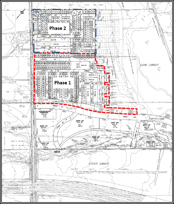
application is to rezone the property such that Phase 1 (Document 2) of the
draft approved plan of subdivision permits the development of a range of
residential uses, including single-detached dwellings, semi-detached dwellings,
townhouses, stacked townhouses and rear lane townhouses. The proposed dwelling
unit breakdown will be as follows:
Single-detached dwellings 160 units
Semi-detached dwellings 52 units
Townhouses 118
units
Stacked Townhouses 124 units
Rear Lane Townhouses 48 units
Total 502
units
Furthermore, the subject amendment
will also implement the Parks and Open Space Zone (O1) which has the effect of ensuring
City parks programming can occur in an appropriate manner on the designated
park block within the plan of subdivision.
Details of Zoning
Amendment
Two residential zones are required to implement
the mix of residential uses proposed within the Arcadia Subdivision - R3YY and
R4Z.
The Residential Third Density R3YY subzone will
allow for a mix of residential building forms ranging from detached to multiple
attached dwellings. An exception to the
R3YY subzone is required to establish varying standards of lot widths, front
yard setbacks, corner yard setbacks and rear yard setbacks (Table 1).
Table 1: R3YY Subzone [XXXX]
|
Subzone |
Principal
Dwelling Type |
Minimum
Lot Width (m) |
Minimum
Lot Area (m2) |
Minimum
Front Yard Setback (m) |
Minimum
Corner Side Yard Setback (m) |
Minimum
Rear Yard Setback (m) |
|||||
|
|
|
Rule |
ZBLA |
Rule |
ZBLA |
Rule |
ZBLA |
Rule |
ZBLA |
Rule |
ZBLA |
|
R3YY |
Detached,
Linked-detached |
9 |
- |
240 |
- |
6 |
3.75 |
4.5 |
2.5 |
6 |
- |
|
R3YY |
Semi-detached |
7 |
6.5 |
190 |
170 |
6 |
3.75 |
4.5 |
2.5 |
6 |
- |
|
R3YY |
Multiple
Attached |
6 |
5.7 |
150 |
120 |
6 |
3.75 |
4.5 |
2.5 |
6 |
- |
|
Notes: |
|
|
|
|
|
|
|
|
|
|
|
ZBLA: means proposed Zoning By-law Amendment provision
Rule:
means current Zoning By-law provision
A second exception to the R3YY
subzone is required to establish varying standards of lot width, lot area,
front yard setback and rear yard setback, for multiple attached dwellings with
public rear lane access (Table 2).
Table 2: R3YY Subzone [XXXY]
|
Subzone |
Principal
Dwelling Type |
Minimum
Lot Width (m) |
Minimum
Lot Area (m2) |
Minimum
Front Yard Setback (m) |
Minimum
Corner Side Yard Setback (m) |
Minimum
Rear Yard Setback (m) |
|||||
|
|
|
Rule |
ZBLA |
Rule |
ZBLA |
Rule |
ZBLA |
Rule |
ZBLA |
Rule |
ZBLA |
|
R3YY |
Multiple
Attached |
6 |
4.0 |
150 |
95 |
6 |
2.0 |
4.5 |
2.5 |
6 |
4.7 |
|
Notes: |
|
|
|
|
|
|
|
|
|
|
|
ZBLA: means proposed Zoning By-law Amendment provision
Rule:
means current Zoning By-law provision
The R3YY
[XXXY] will allow relief from the maximum percentage of hard surface forming
the rear yard on multiple attached units with rear lanes. A maximum of 65 per cent of the area of the
rear yard will permit the use of a driveway, with the remainder required for
landscaping. This will allow a driveway
to be located on these narrow lots, with provisions for landscaping.
The R4Z subzone allows a wide mix of
residential building forms ranging from detached to low-rise apartment
dwellings. Specifically, this subzone is
required to allow for Stacked Townhouses which are the product type to be
constructed in the R4Z zone.
An exception to the R4Z subzone is required to
reduce the required parking rate for stacked townhouses from 1.2 per unit, to
1.0 per unit.Both the R3YY and R4Z zones will restrict porch
projections into the front yard to those with cantilevered foundations.
DISCUSSION
This application has been evaluated against the policies of the Provincial Policy Statement, the Official Plan, the Kanata West Concept Plan, and the Zoning By-law. Staff’s analysis of the proposal, with specific reference to the applicable policies, is provided below.
Provincial Policy
Statement:
The Provincial Policy Statement provides for appropriate development while protecting resources of provincial interest, public health and safety, and the quality of the natural environment. The fundamental principles set out in the Provincial Policy Statement include Building Strong Communities, Wise Use and Management of Resources, and Protecting Public Health and Safety.
The proposed land-uses and zone categories for the plan of subdivision promote the efficient use of land and the creation of a strong, liveable community. Furthermore, development is directed away from natural hazards of the Carp River.
Official Plan
The subject site is designated ‘General Urban Area’. The future Campeau Drive corridor (extending from the Carp River in the east to Huntmar Drive in the west), acts as a boundary at which the ‘General Urban Area’ terminates and the ‘Mixed-Use Centre’ designation begins. Lands south of the future Campeau Drive are subject to a related Zoning By-law Amendment application (D02-02-11-0036).
The General Urban Area designation is intended to allow a full range and choice of housing types to meet the needs of all ages, incomes and life circumstances, in combination with conveniently located employment, retail, service, cultural, leisure, entertainment and institutional uses. These uses are meant to provide for a complete community. The proposed zoning amendment meets with the General Urban Area policies in that the designation permits all types and densities of housing.
Section 2.2.2 of the Official Plan, Managing Growth within the Urban Area, identifies four strategic directions (Managing Growth, Providing Infrastructure, Maintaining Environmental Integrity and Creating Liveable Communities) for meeting the challenges of growth over the next 20 years. The purpose of these directions is to ensure new development is directed to key locations that provide for a mix of uses and community amenities, supports a multi-modal transportation system, utilizes the existing infrastructure and supports the commitment to conserve the natural environment.
The policy direction particular to the subject proposed rezoning is to promote an efficient land-use pattern within the urban area through intensification of locations that are strategically aligned with the transportation network and to achieve higher density development in greenfield locations.
The subject site accommodates the density expectations for greenfield development expressed in the Official Plan. The proposed development plan targets approximately 37 units per hectare, where the Official Plan requires a minimum of 34 units per hectare for ‘Developing Communities’. Although the site is not designated ‘Developing Community’, it encompasses the same characteristics and should respect this minimum density target.
The proposed Zoning Amendment also respects the policies of the Official Plan for providing infrastructure, such as sanitary, water and stormwater services (Section 2.3), and meets the design objectives detailed in Sections 2.5.1 and 4.11 of the Official Plan.
Kanata West Concept
Plan (KWCP)
The site is subject to three KWCP land-use designations, which are: ‘Prestige Business Park / Residential’ north of Campeau Drive, ‘Existing Flood-fringe’ and ‘River / Creek Corridor’ located along the corridor and floodplain limits of the Carp River.
The majority of the lands are made up of the Prestige Business Park / Residential designation north of the future Campeau Drive extension. The policy for this designation states that should the lands be developed as residential, the Land-use and Design Guidelines set out in the KWCP for the Residential Area B designation will apply. The Residential Area B designation policies are intended to permit a range of residential dwelling types in a transit-integrated and pedestrian friendly environment. Residential uses permitted include detached dwellings, semi-detached, townhouses, stacked townhouses, planned unit developments and apartments. Densities within the Residential Area are to be in keeping with post-war communities such as Ottawa South and the Glebe (approximately 30 to 40 units per net hectare).
The Existing Flood-fringe represents those lands that are currently within the 1:100 year floodplain. The Carp River Restoration plan proposes ‘restoration’ of the Carp River through natural channel design and filling 28 hectares of land within the flood plain above the level that would be reached by floodwaters. These ‘existing flood-fringe’ lands would accommodate three stormwater management facilities and urban development.
With respect to the River / Creek Corridors designation, the open space network is identified as following the linked Poole Creek, Feedmill Creek and Carp River corridors. These corridors have been identified as locally significant and will be of sufficient width to accommodate both wildlife and passive recreation. In the Carp River corridor it is the expected that the creation of the riverine wetland will accommodate the channel, floodplain, deep water pools and a recreational pathway.
The density targets for residential development in the KWCP are fulfilled through the proposed zoning, whereby approximately 37 units per hectare will be provided and 30 to 40 units per hectare are targeted. The intention to provide for a diversity of housing units in Kanata West, and specifically within Residential Area B, is met.
Zoning By-law 2008-250
The Zoning By-law Amendment proposes to apply the R3 and R4 zones over the subject lands. The R3 zone allows for a mix of residential building forms ranging from detached to multiple attached dwellings in areas designated as General Urban Area in the Official Plan, while the R4 zone allows for a wider mix of residential buildings than the R3 zone, where building forms range from detached to low-rise apartment dwellings. Both the R3 and R4 zones are designed to permit different development standards which promote efficient land use and compact form while showcasing newer design approaches.
In 2006 the Kanata West Master Servicing Study (KWMSS) was completed which recommended the preferred servicing solutions for the Kanata West Lands. The subject lands are proposed to be serviced off the existing sanitary pump station (Signature Ridge) located on Didsbury Road. The water service is an extension of the existing watermain network and is proposed to extend along the existing Huntmar Road right of way as well extended down the proposed Campeau Road extension. Stormwater is proposed to be treated in a new facility identified as Pond 1 in the KWMSS. In the interim, until the Carp River Restoration Plan and Pond 1 designs are finalized, a temporary pond with the same performance and targets as Pond 1 is being proposed to service the Phase 1 lands. This interim pond will be located outside the Carp River Regulatory Floodplain.
The subject Zoning By-law Amendment (Document 3) meets the intent of the policies set forth in the Provincial Policy Statement, the Official Plan, the Kanata West Concept Plan, and the Zoning By-law.
ENVIRONMENTAL IMPLICATIONS
Council approved the general land use and development principles for Kanata West in 2003 and the Carp Watershed/ Subwatershed Study in 2005. Both plans recommended restoration of the Carp River, a heavily degraded watercourse where historical channel alterations had resulted in sediment accumulation and poor water quality and fish habitat.
Three Class Environmental Assessments (EA) were completed in 2006 to support development of the Kanata West area. To manage all of the planning and development issues in a coordinated fashion the owners of lands within the Kanata West area established the Kanata West Owners Group (KWOG). The City and KWOG acted as co-proponents for the three EAs: the Kanata West Master Servicing Plan for municipal water, sanitary services and stormwater; the Kanata West Transportation Master Plan; and the Carp River, Poole Creek and Feedmill Creek Restoration.
The process of the three EAs developed, evaluated, and selected preferred alternative servicing and restoration scenarios for the Kanata West community at the planning level. The Restoration EA considered alternatives such as do nothing, hardening the river edge or natural channel design. Once natural channel design was selected as the preferred alternative, the EA process considered full restoration or local restoration of the river. Full restoration of the river was ultimately recommended within Kanata West and local restoration was chosen for Poole and Feedmill Creeks.
Altogether, the three EA documents supported 22 infrastructure projects. The Carp River Restoration Plan recommended full restoration of the Carp River to reintroduce bends and increase river stability, improve sediment transport, and enhance biodiversity, among other improvements. The restoration plan also proposed filling 28 hectares of land within the flood plain above the level that would be reached by floodwaters. These lands would accommodate three stormwater management facilities and urban development.
Several organizations and individuals expressed concern about the proposed flood plain encroachment. Following Council approval of the recommended projects and the filing of the notices of completion for the EAs in June 2006, several parties filed Part II Order requests with the Ministry of Environment. These requests asked the Minister of the Environment to consider “bumping up” the Carp River Restoration project and six other projects to a status that would require individual assessments.
In 2007, the Auditor General at the City initiated an audit of the Carp River watershed study and related projects. While the audit was in process, City staff identified missing water flows in the model that was used in the EAs. The Auditor General’s report was released to Council on April 23, 2008 and considered by Council on May 14, 2008. As a result of both the Auditor General’s recommendations and the model errors discovered by staff, the Management Response to the audit recommended that a Third Party Review (TPR) be conducted of the modelling used as the basis for the Carp Restoration Plan and the impact of any errors on the three EA.
The Minister of the Environment issued an order on 21 July 2008 under the Environmental Assessment Act to the City and the Kanata West Owners Group. The order indicated that the documentation of the three EAs must be revised to include the results of the TPR and to address other issues raised by the Ministry.
The TPR was approved by Council on May 27, 2009 authorizing staff to proceed with development applications outside the floodplain in Kanata West subject to its recommendations. The fundamental recommendations included the provision of additional storage to deal with the worst case scenario until such time as the model can be calibrated; ensuring development applications are not dependent on any of the seven contested Class EA projects; and verifying developments are not within the floodplain.
Subsequent to the approval of the TPR a detailed Implementation Plan was prepared for the Kanata West Area that outlined detailed stormwater management runoff volume controls, requirements for model validation and Contingency Plans, ongoing water level and flow rate monitoring plans, a detailed development phasing plan and strict requirements for any interim development.
Significant work on updating the models of record including a permanent corridor widening to account for 25 per cent of the worst case deficit volume was undertaken between June 2009 and June 2010. On July 30, 2010 the Notice of Completion for the Kanata West EAs was filed. On March 30, 2011 the Minister of Environment issued his decision dismissing the Part II Order requests that individual EAs for the seven disputed projects be undertaken.
The Minister’s decision imposes conditions on the City and KWOG that confirm previously agreed to requirements established through the TPR process and commitments in the Kanata West Implementation Plan. The Minister also directed that three of the stormwater management ponds not proceed until such time that the models have been calibrated and validated. The Model Calibration Validation Exercise, Final Report was completed on 13 July of this year and, therefore, all projects can proceed to detailed design including the three stormwater management ponds.
With this decision having been made, the City and the Owner’s Group may proceed with the seven projects subject to the conditions imposed as well as any other permits or approvals required. Completion of the Model Validation Report and approval of implementing Official Plan and Zoning By-law amendments for the Carp River Restoration Project now can be completed based on the Minister’s decision.
For Minto’s site specific project the implementation of the aforementioned Official Plan Amendment and Zoning By-law Amendment for the Carp River corridor and restoration project will be required prior their lands immediately adjacent the Carp River proceeding to approval and construction.
The Minister’s decision brings closure to the required EAs and will allow the City and the landowners to move forward with the necessary infrastructure to support the planned growth in the Kanata West area in a safe and practical manner. The restoration of the Carp River to a natural watercourse with many environmental benefits to the City can now be initiated.
RELATED APPLICATION
The Plan of Subdivision application (File D07-16-06-0028) which had the effect of determining the subdivision design and street pattern was approved July 28th, 2010. This subdivision plan comprises 750 dwelling units on 347 residential lots, 15 residential blocks and eight mixed-use commercial blocks and features three transit-way blocks and one park block.
RURAL IMPLICATIONS
N/A
CONSULTATION
Notice of this application was carried out in accordance with the City's Public Notification and Consultation Policy. The City did not receive any negative comments or opposition to this application. Nonetheless, the comments received are outlined in Document 4.
COMMENTS BY THE WARD
COUNCILLOR(S)
The Ward Councillor is aware of this application and the staff recommendation.
LEGAL IMPLICATIONS
There are no legal implications associated with this report.
RISK MANAGEMENT IMPLICATIONS
N/A
CITY STRATEGIC PLAN
Regarding the Planning and Growth Management objectives of the City’s Strategic Plan, the subject rezoning and associated Plan of Subdivision, meet Objectives 1 and 3 whereby;
1. The purpose of Objective 1 is to manage growth and create sustainable communities; and
2. The purpose of Objective 2 is to ensure that the City’s infrastructure required for new growth is built or improved as needed to serve the growth.
FINANCIAL IMPLICATIONS
There are no direct financial implications associated with this report.
APPLICATION PROCESS TIMELINE STATUS
The application was not processed by the "On Time Decision Date" established for the processing of Zoning By-law amendments due to time required for the third party engineering review of stormwater management modelling to be completed and deemed satisfactory.
SUPPORTING DOCUMENTATION
Document 1 Location / Zoning Map
Document 2 Phase 1 Zoning
Document 3 Details of Recommended Zoning
Document 4 Consultation Details
DISPOSITION
City Clerk and Solicitor Department, Legislative Services to notify the owner/applicant, Attn: Jamie Kipp, 427 Laurier Ave. West, Suite 300, Ottawa, ON K1R 7Y2; OttawaScene.com, 174 Colonnade Road, Unit #33, Ottawa, ON K2E 7J5; Ghislain Lamarche, Program Manager, Assessment, Financial Services Branch (Mail Code: 26-76) of City Council’s decision.
Planning and Growth Management to prepare the implementing by-law, forward to Legal Services and undertake the statutory notification.
Legal Services to forward the implementing by-law to City Council.
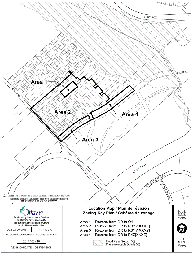
LOCATION / ZONING MAP DOCUMENT
1
PHASE 1 ZONING DOCUMENT 2
DETAILS OF RECOMMENDED ZONING DOCUMENT 3
Residential Third Density Exception Zone
R3YY [XXXX]:
1.Rezone the lands shown in Document 1 as follows:
Area 1 from DR to O1;
Area 2 from DR to R3YY[XXXX]
Area 3 from DR to R3YY[XXXY]; and,
Area 4 from DR to R4Z[XXXZ]
2. Add a new exception, R3YY[XXXX], to Section 239 – Urban Exceptions with provisions similar in effect to the following:
In Column II the text “R3YY[XXXX]”; and,
In Column V the text:
Zone requirements for detached dwellings:
1. Minimum Front Yard Setback: 3.75 metres
2. Minimum Corner Side Yard Setback: 2.5 metres
Zone requirements for semi-detached dwellings:
1. Minimum Lot Width: 6.5 metres
2. Minimum Lot Area: 170 square metres
3. Minimum Front Yard Setback: 3.75 metres
4. Minimum Corner Side Yard Setback: 2.5 metres
Zone requirements for multiple attached dwellings
1. Minimum Lot Width: 5.7 metres
2. Minimum Lot Area: 120 square metres
3. Minimum Front Yard Setback: 3.75 metres
4. Minimum Corner Side Yard Setback: 2.5 metres
3. Add a new exception, R3YY[XXXY], to Section 239 – Urban Exceptions with provisions similar in effect to the following:
In Column II the text “R3YY[XXXY]”; and,
In Column V the text:
Zone requirements for multiple attached dwellings
1. Campeau Drive is deemed the front lot line
2. Minimum Lot Width: 4.0 metres
3. Minimum Lot Area: 95 square metres
4. Minimum Front Yard Setback: 2.0 metres
5. Minimum Corner Side Yard Setback: 2.5 metres
6. Minimum Rear Yard Setback: 4.7 metres
7. Section 135 does not apply
- despite section 65:
(i) except for a cantilevered foundation, no part of a foundation for a permitted projection is permitted within a front yard;
- despite
section 109 (12) where a multiple attached dwelling accesses a parking space
from a driveway within the rear yard, a maximum of 65 per cent of the area of the
rear yard, or the required minimum width of one parking space, whichever is the
greater, may be used for a driveway, and the remainder of the rear yard, except
for areas occupied by projections permitted under Section 65, must be
landscaped with soft landscaping
- despite clause 59(1)(b), access to a lot may be provided by means of a rear lane a minimum of 8.5 metres in width instead of by a public street.
4. Add a new exception, R4Z[XXXZ], to Section 239 – Urban Exceptions with provisions similar in effect to the following:
In Column II the text “R3YY[XXXX]”; and,
In Column V the text:
- despite
Section 101 Table 101 (r) the required parking rate for stacked townhouses is reduced from 1.2 per unit, to 1.0
per unit.
- despite section 65:
(i) except for a cantilevered foundation, no part of a foundation for a permitted projection is permitted within a front yard;
CONSULTATION DETAILS DOCUMENT 4
NOTIFICATION AND CONSULTATION PROCESS
Notification and public consultation was undertaken in accordance with the Public Notification and Public Consultation Policy approved by City Council for Zoning By-law amendments. A Community Information Session was held in the community on March 29th, 2007.
COUNCILLOR’S COMMENTS
Councillor Wilkinson had no comments.
ADVISORY COMMITTEE COMMENTS
The Ottawa Forests and Greenspace Advisory Committee (OFGAC) provided the following comments and recommendations:
It is recommended that the current trees along both sides of Feedmill Creek be retained to ensure a naturalized border. Retain as many trees and shrubs in the area to be naturalized as is possible while removing invasive species, such as buckthorn, if they occur.
The site plan for the development should be reviewed to ensure adequate and appropriate planting of trees and shrubs in the new development.
As for zoning the land from agriculture (from the former City of Kanata Zoning By-law) to residential, this is not seen as an issue as:
- The land has not recently been used for agriculture and being so close to the city will not likely be used for agriculture;
- The land is within the urban boundary;
- Other than the trees along the creek, there are no trees or vegetation that requires preservation; and
- There is recent home development in close proximity to this site - one kilometre east is Kanata Lakes and one to two kilometres south is the new Mattamy Homes development along Maple Grove Road.
Staff Response
The recommendations put forth by OFGAC to maintain trees and vegetation along Feedmill Creek will be implemented through the Plan of Subdivision process.