|
4. ZONING - 300 CENTRAL PARK DRIVE,
1232 MERIVALE ROAD, 1230 MERIVALE ROAD AND 1 CRYSTAL PARK CRESCENT ZONAGE – 300, PROMENADE CENTRAL PARK, 1232, CHEMIN
MERIVALE, 1230, CHEMIN MERIVALE ET 1, CROISSANT CRYSTAL PARK |
Committee
recommendation
(This matter is
Subject to Bill 51)
That Council
approve an amendment to the Zoning By-law 2008-250 to change the zoning of 1232
Merivale Road, 1230 Merivale Road, 1 Crystal Park Crescent and part of 300
Central Park Drive all of which are shown on Document 1 from AM5[134] H(28) - Arterial Mainstreet,
Subzone Five Exception 134, AM1, Arterial Mainstreet, Subzone One, R5K[836] H(28) – Residential Fifth Density,
Subzone K Exception 836 and AM2[133] – Arterial Mainstreet Subzone Two,
Exception 133 to AM[XXXX] SYYY, SZZZ-h, Arterial Mainstreet
with an exception, holding symbol and schedule, as detailed in Documents 2, 3
and 4.
Recommandation DU Comité
(Cette question est assujettie au Règlement 51)
Que le Conseil approuve une modification au Règlement de zonage 2008-250 en vue de faire passer le zonage du
1232, chemin Merivale, du 1230, chemin Merivale, du 1, croissant Crystal Park
et d’une partie du 300, promenade Central Park, illustrés dans le document 1,
de AM5[134] H(28) – Artère principale, sous-zone Cinq, exception 134,
AM1, Artère principale, sous-zone Un, R5K[836] H(28) – Zone résidentielle de
densité Cinq, sous-zone K, exception 836 et AM2[133] – Artère principale,
sous-zone Deux, exception 133 à
AM[XXXX] SYYY, SZZZ-h, Artère principale assortie d’une exception, d’un symbole d’aménagement différé et d’une
annexe, tel qu’exposé en détail dans les documents 2, 3 et 4.
Documentation
1.
Deputy
City Manager's report, Infrastructure
Services and Community Sustainability, dated 25 October 2011 (ACS2011-ICS-PGM-0192).
2. Extract of
Draft Minutes, Planning Committee meeting of 8 November 2011.
Report
to/Rapport au:
Comité
de l'urbanisme
and Council / et au Conseil
25 October
2011 / le 25 octobre 2011
Submitted by/Soumis par : Nancy
Schepers, Deputy City Manager/
Directrice municipale adjointe, Infrastructure Services and Community
Sustainability/Services d’infrastructure et Viabilité des collectivités
Contact Person/Personne-ressource : John Smit, Manager/Gestionnaire,
Development Review-Urban Services/Examen des projets d'aménagement-Services Urbains,
Planning and Growth Management/Urbanisme et Gestion de la croissance
(613) 580-2424, 13866
John.Smit@ottawa.ca
REPORT RECOMMENDATION
That the recommend Council approve an amendment to the
Zoning By-law 2008-250 to change the zoning of 1232 Merivale Road, 1230
Merivale Road, 1 Crystal Park Crescent and part of 300 Central Park Drive all
of which are shown on Document 1 from AM5[134]
H(28) - Arterial Mainstreet, Subzone Five Exception 134, AM1, Arterial
Mainstreet, Subzone One, R5K[836] H(28)
– Residential Fifth Density, Subzone K Exception 836 and AM2[133] – Arterial
Mainstreet Subzone Two, Exception 133 to AM[XXXX] SYYY, SZZZ-h, Arterial Mainstreet
with an exception, holding symbol and schedule, as detailed in Documents 2, 3
and 4.
RECOMMANDATION DU RAPPORT
Que le Comité de recommande au Conseil d’approuver une
modification au Règlement de zonage 2008-250 en vue de faire passer le
zonage du 1232, chemin Merivale, du 1230, chemin Merivale, du 1, croissant
Crystal Park et d’une partie du 300, promenade Central Park, illustrés dans le
document 1, de AM5[134] H(28) –
Artère principale, sous-zone Cinq, exception 134, AM1, Artère principale,
sous-zone Un, R5K[836] H(28) – Zone résidentielle de densité Cinq, sous-zone K,
exception 836 et AM2[133] – Artère principale, sous-zone Deux, exception 133 à AM[XXXX] SYYY, SZZZ-h, Artère
principale assortie d’une exception,
d’un symbole d’aménagement différé et d’une annexe, tel qu’exposé en détail
dans les documents 2, 3 et 4.
BACKGROUND
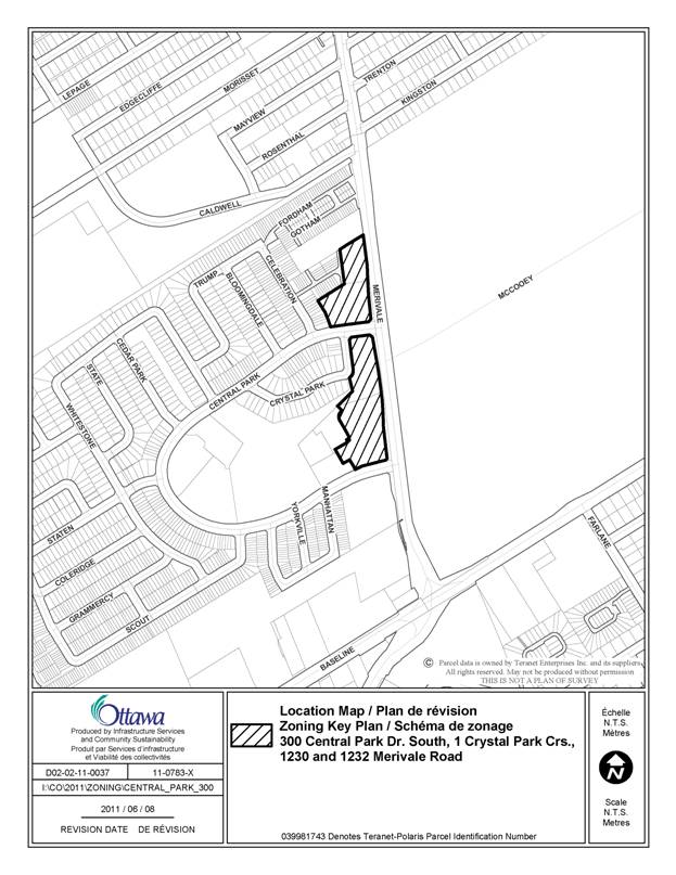
The application involves four properties which are located north of Baseline Road on the west side of Merivale Road as shown on Document 1. The four properties form the western edge or limit of the established Central Park Community with a combined frontage of 431 metres and area of 2.7 hectares. 1230 Merivale Road and 300 Central Park Drive are currently undeveloped parcels of land. 1 Crystal Park Crescent is largely vacant except for an existing sales pavilion. 1232 Merivale Road is a developed commercial site with a strip plaza and standalone pad restaurant. Abutting the properties to the west is a mix of residential building forms which includes high-rise apartments, detached homes and townhouses. To the east, across Merivale Road is the Central Experimental Farm. To the south of the property along Baseline Road there is a surface parking lot and Federal office complex.
Purpose of Zoning Amendment
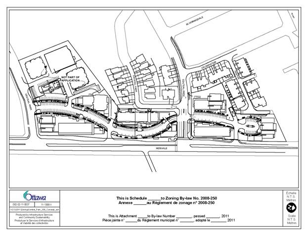
The purpose of the application is to establish a new, uniform Arterial Mainstreet zone for the subject properties to replace the current multiple zones that are in place so as to facilitate the proposed development concept as shown on Document 4. The application is not requesting an increase in the current level of development permitted by the current zoning, but rather to provide for redistribution of the intensity of development currently permitted within an alternative built form program comprising point towers set over pedestrian scale podium buildings and lower profile development for certain areas of the site so as to improve integration of the permitted scale of development with the adjacent community.
The proposed development is focused around the creation of a new focal point for the Central Park community. Safe, attractive and well-designed pedestrian scale elements will establish the site as a people and pedestrian area. The new focus would be established through the provision of a mix of uses including residential units, retail and commercial space along with open space, landscaping and pedestrian walkways, all of which will contribute towards the creation of a sense of place. The design is centred around a new internal road that would in effect create the desired environment while responding to the contextual challenge of the area.
The new internal road would be framed by seven buildings on either side of the street as it meanders over the site. The proposed buildings would range in height from 11 metres to 81 metres and will be both mixed-use (commercial/residential) and stand alone commercial or residential structures. The tallest elements are proposed to be located towards the northern and southern edge of the site transitioning downwards towards the centre of site and downwards towards the existing community to the west. The remainder of the site would be complimented with new landscaping, pedestrian linkages and public spaces. The combined retail, office and residential square footage proposed for the site is approximately 87,000 square metres.
Parking for the site would be accommodated on-site with the majority of the parking provided underground.
The overall development would be phased, with the first phase of construction consisting of a mixed-use commercial/residential building and a stand-alone retail pad located in the centre of the overall site.
Existing Zoning
300 Central Park Drive is currently zoned AM5[134] H(28) - Arterial Mainstreet, Subzone Five Exception 134. The current zoning also has a maximum permitted height of 28 metres. The current subzone permits a range or residential and non-residential uses such as office, high-rise residential and a planned unit development, along with the provision for additional non-residential uses such as a restaurant, retail store and bank. The additional uses must be provided on the same lot or within the same building as a permitted use. Exception 134 sets out site specific exceptions related to the location and size of commercial uses.
1 Crystal Park Crescent is currently zoned AM2[133] – Arterial Mainstreet Subzone Two, Exception 133. Subzone 2 permits a wide range of residential and non-residential uses listed in the parent zone, and specifically prohibits uses such as amusement centre, amusement park, bar, and cinema. Exception 133 sets out site-specific exceptions related to development involving multiple zones, the location of patios, cumulative gross floor area for development, minimum landscaping and minimum yard requirements.
1232 Merivale Road is currently zoned AM1, Arterial Mainstreet, Subzone One. Subzone One does not restrict or prohibit the range of uses listed in the parent zone; however it does limit the amount of floor space that may be dedicated to non-residential uses. Up to 50% of the permitted floor space index may be used for non-residential uses.
1230 Merivale Road is currently zoned R5K[836] H(28) – Residential Fifth Density, Subzone K. The residential subzone permits a wide range and density of residential built forms such as planned unit developments and high-rise apartment buildings to a maximum height of 28 metres. Exception 836 allows for limited non-residential uses such as a bank, office or retail store up to a cumulative maximum of 2,000 square metres.
Proposed Zoning
The application proposes to
establish a new site-specific Arterial Mainstreet (AM) zone for the subject
properties. The recommended zoning would
also establish a new schedule which would regulate both the maximum permitted
heights and minimum setbacks for the entire site. To ensure the development of the site occurs
in accordance with the concept shown on Document 4, a holding provision is
proposed to require that an overall site plan application that reflects the
development concept shown on Document 4 be approved prior to any construction
proceeding. The holding provisions will
facilitate a phased development where each phase brought forward would be
required to be generally consistent with the overall site plan that reflects
the concept plan as to not allow for a significant reconfiguration or redesign
of the site.
While an overall site plan will be approved, where development is to be phased,
each phase prior to proceeding will be subject to a revised application for
Site Plan Control and would be subject to public notice and consultation.
The holding provisions will also require and that roadway modifications that may be required for each phase of the proposed development be approved prior to the holding provisions to allow that phase of development to proceed.
DISCUSSION
The subject site is located within a developed urban area with a high potential for development in a form which advances the policy the overall strategic directions of the Official Plan dealing with growth management and the specific policy objectives set out for Arterial Mainstreets. The proposed rezoning will allow for accommodating high density mixed use development in a form that is responsive to the site’s urban context and to support achieving complete and transit supportive communities.
Official Plan
Strategic Directions
Section 2 of the Official Plan sets strategic directions to meet the challenge of managing growth, and creating liveable communities within Ottawa. To meet these challenges, there is clear direction to provide for a mix of land uses and compact forms of development at strategic locations that will enable the City to support transit and make better use of existing infrastructure and roads. Consistent with this broad direction, Section 2.2.3 specifically directs growth within the Urban Area to locations with significant development potential, such as areas designated Central Area, Mixed-Use Centers, Developing Communities and Mainstreets. The objective for these areas is to have them develop as mixed-use areas, which includes housing, employment, shopping and recreation and at a density that can facilitate a level of intensification that achieves the City’s objectives with respect to intensification and fits and works relative to the site’s urban context. Consistent with these directions the site is located along a designated Arterial Mainstreet with a fully serviced area and currently allows for significant development potential. Redistributing how this development will be provided responds to those directions set out in Section 2 that are focused on providing for integration of new development within their urban context and achieving high quality design standards that support the creation of strong pedestrian focused environments. The proposed development will accommodate a mix of land uses (commercial, retail and residential) within both stand alone commercial and mixed use buildings to contribute to the creation of a complete community for the Central park neighbourhood.
Land Use Designation
The subject property is designated Arterial Mainstreet in the Official
Plan. The Mainstreet designation
identifies streets that offer some of the most significant opportunities for
intensification through compact development and a mix of uses.
In addition to encouraging more intense mixed-use development, another
key direction for Arterial Mainstreets is for development to have a strong
street orientation so that Arterial Mainstreets can evolve from predominantly
vehicular corridors to more comfortable, animated pedestrian corridors that can
contribute to these streets becoming linkages between communities rather than
edges to communities.
Recognizing the ability and need for Arterial Mainstreets to accommodate higher profile development envisioned in the Official Plan, heights along arterial mainstreets under the Official Plan can be up to eight stories with higher heights permitted under any one of a number of conditions. The subject site meets several of these conditions and therefore is appropriate for buildings higher than eight stories. The proposed buildings foster the creation of a community focus at a gateway location to the existing Central Park community and provides a transition from the existing higher profile residential buildings at the Merivale Road edge moving from east to west.
To achieve the desired street profile for Arterial Mainstreets while considering the challenge of this specific section of Merivale Road, the application proposes to create a new internal, two‑sided corridor with a strong pedestrian focus rather than a one-sided face along Merivale Road. The intent is to pull the desired street element onto the site with a strong pedestrian realm and built form which would otherwise be difficult to achieve in a manner that relates well to either Merivale Road or the Central Park community.
Compatibility Considerations
Section 2.5.1 sets out broad design objectives as qualitative statements on how the City will influence the evolution of the built environment. These objectives are focused on enhancing the sense of community and maintaining places with their own distinct identity, providing quality public and private spaces through development, creating places that are safe, accessible and are easy to get to and move through, ensuring that new development respects the character of existing areas, and creating places that can adapt easily and evolve over time. Design principles further describe how each of the design objectives may be achieved.
The proposed development achieves the design principles of considering the street as a public space with a well-thought out streetscape and consisting of continuous building frontages that are designed with the pedestrian experience in mind. In recognition of the site’s context forming the face for the Central Park community and that Merivale Road at this location does not offer the potential for development to embrace the street on both the east and west side given that the lands across Merivale Road accommodate the experimental farm, the applicant proposes to develop a new internal pedestrian focused corridor reminiscent of a more traditional mainstreet to flank Merivale Road while also still interacting with Merivale Road at strategic points so as to engage both the internal street and Merivale Road. This approach is considered an innovative and appropriate design response for this site and works well to achieve a community focus and integrate the site with the existing community and the arterial road through pathways and sidewalks to encourage ease of movement through the site. Further, the proposed programming of the site and mix of uses creates spaces that are publicly accessible, safe and active through all hours of the day.
The proposed rezoning to allow for a redistribution of the allowed intensity of development through increased heights will allow the development to accommodate the current density within tower forms rather than a bulky mid-rise form that would create a sense of enclosure for the community. The point tower development form over podiums provides for positioning of towers to contribute to creating a visual gateway to the community at the Merivale Road / Central Park Drive access points and provides for achieving a strong human scale development form for the new internal pedestrian focused corridor. Also, use of a point tower development retains sky-views and allows the development program to be designed as an integral element of the community from a building spatial organization perspective.
Section 4.11 of the Official Plan as well as the City’s Urban Design Guidelines provide further direction on design and compatible development. The proposal was reviewed in light of the Urban Design Guidelines for Arterial Mainstreets and High Rise Housing. The following is an analysis of the applicable criteria in Section 4.11 of the Official Plan.
Height and Massing
New buildings are to have regard to the area context, massing and height of adjacent buildings however the Official Plan does not require a new building to be the same as other buildings to be considered compatible. It is recognized that the Central Park community itself is characterized largely as a low-rise community with a mix of housing types and with higher profile buildings located towards the edge of the community such as an 11-storey apartment building abutting 1230 Merivale Road, and two ten-storey condominiums abutting 300 Central Park Road. In response to the existing built form and height, the massing scheme has been designed with the tallest elements bookending the site in the areas of the existing tallest buildings. The proposed 25 and 18 storey towers have been located adjacent to existing towers and are separated from each other by a minimum of 70 metres to allow for light and air circulation over the site and a minimal impact on existing views. The footprint of the towers is reduced to create a more slender form which has the effect of casting a taller but narrower shadow over adjacent properties that will move faster through the community thereby minimizing impacts.
Transportation
A traffic impact study was prepared in support of the application and has been reviewed by staff. The study confirmed that the existing transportation network can adequately service the permitted level of development. In this regard, it is noted that the intensity of development is not increasing over what is currently allowed by the existing zoning, but rather that the rezoning is to allow for the permitted intensity of development to be accommodated in a different form.
The detailed roadway modifications that may be required to address safe turning movements, stacking and land configurations will be addressed through the Site Plan Control process prior to the lifting of the holding provision related to each phase of development.
Access
The development concept is proposing five access points to the site, two along Merivale Road which would be limited to right-in and right-out only movements, one from Central Park Drive South and two from Central Park Drive North. The proposed access points provide for distribution of site access opportunities, and enhance the connectivity of the site for pass by traffic and for the community. The details for the site accesses will be finalized through the Site Plan Control process prior to the lifting of the Holding provision relative to each phase of development. Providing for several access points provides for appropriate distribution of site traffic to allow for acceptable driveway operations.
Parking
Parking for the proposed development is to be provided both at grade and underground. The majority of the parking for the site will be provided underground and will be serviced via two ramps. Details related to the design, lighting and screening of parking and loading areas will be addressed through the Site Plan Control approval process.
Pattern of the Surrounding Community
The proposed pattern of development builds upon the existing built form and planned function for this section of Merivale Road. The southern and northern limits of the site abut existing towers ranging in height from 10 to 11 stories. The tallest tower elements have been located at these ends of the site closest to Merivale Road, with the heights decreasing then moving towards the west. The varying built forms, building setbacks and podium features create an appropriate human scale at the ground level and further mitigate the taller building elements.
Ottawa Urban Design Review Panel
The
subject property is located within a Design Priority Area and was subject to
review by the Urban Design Review Panel.
The applicant had a pre-consultation with the Panel on December 2, 2010. In summary, the Panel supported the direction
of the proposed development acknowledging that Merivale Road is inherently a
poor pedestrian environment. The creation of an internal pedestrian priority
spine was considered an appropriate response by the Panel. The Panel noted that pedestrians must be more
of a priority and the area cannot be predominately asphalt and that the nature
of the spine and the materiality of the pedestrian realm are important. The Panel noted the importance of the
relationship to the Experimental Farm and stressed the importance of pedestrian
connections between the Farm and the development. A formal presentation to the Urban Design
Review Panel will take place later this year prior to the completion of the
Site Plan Control process.
Arterial
Mainstreet and High Rise Development Guidelines
Staff have reviewed the development proposed by the applicant in the
context of the above Council approved guidelines. Based on this review, staff have concluded
that the applicant’s development program has addressed the planning principles
and design objectives set out in the Official Plan and in the above-noted
guidelines.
The proposed development redefines and reprograms the subject
properties from a series of individual parcels into a contiguous development and
streetscape that is in keeping with the Arterial Mainstreet designation. The concept supports a mix of uses and
incorporates public spaces that are highly accessible.
With respect to the Guidelines for High Rise Development, the proposed concept addresses design elements which speak to built form, open space, the public and pedestrian realm and environmental considerations. The proposed concept establishes a pattern of development block and street edges which defines public and private spaces. The proposed built form creates a transition to the existing low profile and high-rise developments. The design of the building podium levels are done so to create a human scale streetscape with higher elements stepped back.
The orientation and separation of the towers minimize microclimate impacts by providing appropriate spacing to allow for sun and air movement, along with a minimal floor plate to reduce shadowing impacts.
Design elements that require refinement to ensure an appropriate and compatible design will be addressed through the completion of the Site Plan Control process. These include landscaping, lighting, and the screening of loading areas and pedestrian systems.
Heritage Considerations
The subject property is located across the street from the Central Experimental Farm which is designated as a national historic site. A Cultural Heritage Impact Statement was undertaken by the applicant to determine the potential impact of the development on the cultural heritage value of the Central Experimental Farm. The study was accepted by staff which determined that the proposed development would not have a negative effect upon cultural heritage value of this part of the Central Experimental Farm.
Concurrent Application
An application for site plan control (File D07-12-11-0136) is currently under consideration. This application is to reflect the development concept depicted in Document 4 and will provide the details for the first phase of the development to allow this phase to proceed. Subsequent phases will require the submission of revised site plan applications that would be required under the holding provisions to provide for the implementation of the development concept reflected in Document 4.
RURAL IMPLICATIONS
N/A
CONSULTATION
Notice
of this application was carried out in accordance with the City's Public
Notification and Consultation Policy.
Through the above process 40 letters and e-mails and one petition were
received in oppostion to the proposed application. A summary of the comments received and a
staff response are found in Document 5.
COMMENTS BY THE WARD COUNCILLOR(S)
The Councillor is aware of the application.
LEGAL IMPLICATIONS
As this item has generated opposition from residents, if approved there may be an appeal brought before the Ontario Municipal Board. It is anticipated that a hearing on this matter would take approximately three to five days and would use internal resources. If the item is not approved by Council, it is likely that the Applicant will bring an appeal to the Ontario Municipal Board.
In this case, Council will have to provide written reasons for its decision and the City will have to retain an external planning expert, as well as an external architect and traffic expert. A three to five day hearing using external resources is estimated at approximately $65,000-$75,000.
RISK MANAGEMENT IMPLICATIONS
N/A
FINANCIAL IMPLICATIONS
Potential costs are outlined in the Legal Implications section above. Should the services of an external planner, an external architect and traffic expert be required, funds ($65,000 to $75,000) are not available within existing budget, and the expense may impact Planning and Growth Management’s operating budget status.
ENVIRONMENTAL IMPLICATIONS
N/A
TECHNOLOGY IMPLICATIONS
CITY STRATEGIC PLAN
The application is consistent with the Planning and Growth Management objective of managing growth and creating sustainable communities by becoming a leading edge community in urban design.
APPLICATION PROCESS TIMELINE STATUS
The application was not processed by the "On Time Decision Date" established for the processing of Zoning By-law amendments due to additional time required to address engineering and transportation items.
SUPPORTING DOCUMENTATION
Document 1 Location Map
Document 2 Details of Recommended Zoning
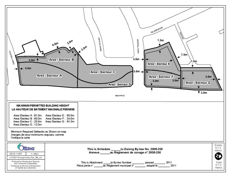
Document 3 Zoning Schedule
Document 4 Concept Plan
Document 5 Consultation Details
DISPOSITION
City Clerk and Solicitor Department, Legislative Services to notify the owner, applicant, OttawaScene Canada Signs, 1565 Chatelain Avenue, Ottawa, ON K1Z 8B5, Ghislain Lamarche, Program Manager, Assessment, Financial Services Branch (Mail Code: 26-76) of City Council’s decision.
Planning and Growth Management to prepare the implementing by-law, forward to Legal Services and undertake the statutory notification.
Legal Services to forward the implementing by-law to City Council.
LOCATION MAP DOCUMENT 1
DETAILS OF RECOMMENDED ZONING DOCUMENT 2
- Rezone the lands shown in Document 1 from AM5[134] H(28), AM1, AM2[133] and R5K[836] H(28) to AM[XXXX] SYYY-h
- Add a new exception, AM[XXXX] SYYY-h to Section 239 with provisions similar in effect to the following:
In Column II, identify that the exception provisions apply to the “AM[XXXX] SYYY” zone;
In Column IV, identify that the following are not permitted uses:
· all uses except existing uses until the holding symbol is removed
· nightclub
·
automobile dealership
·
automobile rental establishment
·
automobile service station”
In Column V, establish the following zone specific provisions:
· maximum floor space index: 3.4
· All lands within the AM[XXXX] SYYY zone are to be considered as one lot for zoning purposes when applying the provisions of the AM[XXXX] SYYY zone.
· Despite the definition of floor space Index set out in the general provisions, floor space index shall be calculated as the ratio of the gross floor area of all buildings located on the lands zoned AM[XXXX] SYYY to the total area of all lands zoned AM[XXXX] SYYY
· maximum total number of surface parking spaces permitted over all the lands zoned AM[XXXX] SYYY: 170
· Table 185 (c) through (f) inclusive that applies to the standard AM zone do not apply and minimum setbacks and maximum building heights are as set out on Schedule YYY
· Despite Section 100(1)(c) setting out general provisions for parking, parking spaces for all uses may be located on a separate lot provided the lot is within the AM[XXXX] SYYY zone
· Outdoor storage is prohibited.
· Subsections 111(8) to (11) of the standard AM zone dealing with the location of bicycle parking do not apply.
· Table 111B of the standard AM zone dealing with minimum bicycle parking space dimensions do not apply.
·
Despite
clause 107(1)(a) of the general provisions setting out requirements for
driveways or ramps providing access to a parking lot or parking garage must
have a minimum width of 6.0m.
·
Parking for a use may be located
anywhere within the AM[XXXX[ SYYY zone.
· Provide for the holding symbol only being removed where:
1. A Site Plan for the overall development that reflects the development concept shown on Schedule ZZZ has been approved and where phased development is proposed, the details for the Phase to be developed has received approval through a formal site plan approval process either as part of the initial site plan for the entire development or through a revised site plan application where each phase reflects a development program that is consistent with and will provide for implementation of the development concept shown on schedule ZZZ. An excavation permit may be issued prior to the lifting of the holding provision for any phase of development provided that a complete site plan application for that phase of development has been submitted.
2. Where a development proposal is submitted as part of any site plan application for any development of the lands zoned AM[XXXX] SYYY that provides for a residential unit count in excess of 800 units for the entirety of the lands zoned AM[XXXX] SYYY, such a site plan will only be approved to allow such a development proposal where a traffic impact assessment has been completed and accepted by the City that demonstrates that the area transportation system will be able to accommodate the traffic generated by the additional dwelling units proposed failing which the development for which site plan approval is being sought will require modification to provide for the entirety of the lands zoned AM[XXXX] SYYY not having a residential unit count exceeding 800 units.
3. Details related to all required site accesses have been confirmed and approved by the General Manager, Planning and Growth Management for both interim, where phased development is proposed, and end state conditions with particular attention to the site access points from the north leg of Central Park Drive. These details will identify any roadway modifications that may be required as part of the overall development program and for interim/phased developments and will include measures that may not require immediate implementation but that may be required to address potential areas of concern that may be identified through monitoring after completion of each phase of development and for the end state development. The details shall also include the details of the monitoring to be undertaken. Conditions related to measures to be implemented as part of each development phase, those that will be deferred pending monitoring after completion to determine the need for the measures, details related to implementation of measures to be implemented as part of a development and that may be required after monitoring, and the posting of any required securities and the monitoring details and schedule will be included as conditions for site plan approval relative to the development phase that the site access is required for.
- Add Documents 3 and 4 to Part 17 – Schedules.
ZONING SCHEDULE DOCUMENT 3
SCHEDULE - CONCEPT PLAN DOCUMENT 4
CONSULTATION DETAILS DOCUMENT 5
NOTIFICATION AND CONSULTATION PROCESS
Notification and public consultation was undertaken in accordance with the Public Notification and Public Consultation Policy approved by City Council for Zoning By-law amendments. A public meeting was also held in the community on December 13, 2010 which was organized by the Ward Councillor and attended by staff and the applicant.
PUBLIC COMMENTS
1. Concerns were raised with respect to the impact on views from the existing residential condominium.
Response: The location and separation of the towers in the overall layout has been proposed to reduce any potential impacts on the existing views. The proposed concept provides for locating the tower elements towards the north and south end of the site, in proximity to the existing high-rise towers in the area, as well the 18 and 25-storey towers on either end of the site are separated by a minimum of 70 metres from each other. As well, the towers have been designed with a smaller building footprint and overall narrow design to allow maximum views to be retained.
2. Concerns were raised with respect to the increase in traffic in the area as a result of the proposed development.
Response: A traffic impact study was prepared in support of the application and determined that the existing transportation network can appropriately service the level of traffic to be generated as a result of the full build-out of the site. As noted previously, the intensity of development is not increasing over what is currently permitted by the existing zoning, but rather the rezoning application is to allow for the permitted intensity of development to be accommodated in an alternate built form. The roadway modifications that may be required to address safe turning movements, stacking and land configurations will be addressed through the Site Plan Control process prior to the lifting of the holding provision relative to each phase of development.
3. Concerns were raised with respect to the location of the taller buildings and their impact on the existing lower-profile dwellings.
Response: The location of the taller buildings have been positioned to create the effect of bookending the proposed development upon its build-out as well as creating a downward transition towards the centre of the site as well as when moving from east to west toward the existing lower profile homes. With respect to individual buildings, based on comments from staff and the public, Building Five has also been shifted further to the south and east to increase the separation distance of the building from the homes along Festive Private. The new setback to be reflected on the implementing by-law schedule is 7.5 metres (24 feet). The actual separation to the tower element of Building 5 to the abutting property line will be over 10 metres (32 feet).
4. Concerns were raised with respect to the loss of sunlight and shadowing impacts from the proposed towers.
Response: The proposed location and the separation of the towers on the site has considered the potential impacts, shadowing, sunlight and microclimate on the abutting homes to the west. The combination of the shape and footprint of the proposed towers and the actual separation distance between the structures allows for a minimal shadow to be projected which moves faster through the abutting neighbourhood as a result of the small floor plates for the proposed point towers. As well, the position of the buildings allows for view towards the Experimental Farm to be preserved with minimal interruption.
5. Concerns were raised with respect to the lack of consultation on the proposed development.
Response: An information session on the proposal was organized by the Councillors office on December 13, 2010. The meeting was held prior to the formal submission of the application for change in zoning. The meeting was advertised to residents of the Central Park community with approximately 50 residents attending along with staff and the applicant. The application, once submitted has been subject to the public consultation requirements of the City of Ottawa.
December 13, 2011 - PUBLIC MEETING COMMENTS
1. A question was asked about the timing of the project and more specifically the removal of the existing Tim Horton’s restaurant.
Response: The development concept does propose that the exiting strip plaza and pad store would be removed and replaced with new buildings in the later phases of development. The project would start with the “centre” portion of the site being developed, then move to the southern portion of the project site. Various factors would also impact the ultimate build-out and construction of the remaining phases.
2. Concerns were raised with the potential impact on property values as a result of the proposed development.
Response: Staff have received no information to either support or refute this claim.
3. A question was asked about the tenure of the proposed new street and public access to the site.
Response: The new internal road would be a privately owned and maintained street that would be accessible by the public. A major component in the design philosophy of the project was to create a pedestrian oriented mainstreet that would create a new focal point for the Central Park community.
4. Concerns were raised with respect to potential property damage in the community as a result of blasting during construction.
Response: Through the review of the Site Plan Control application staff will determine with the applicant if there is indeed the requirement for blasting. Should blasting be required, staff will incorporate an appropriate condition to require the proper testing and assessment of existing properties.