2.             WEST TRANSITWAY EXTENSION (SOUTHWEST TRANSITWAY TO PINECREST ROAD) PLANNING AND ENVIRONMENTAL ASSESSMENT STUDY UPDATE AND RECOMMENDATIONS


étude de planification et d’évaluation environnementale du prolongement du TRANSITWAY ouest (du TRANSITWAY sud-ouest au chemin PINECREST) : mise à jour et recommandations


COMMITTEE RECOMMENDATIONS


That Council:


1.                  receive the update to the West Transitway Extension (Southwest Transitway to Pinecrest Road) Planning and Environmental Assessment Study and direct staff to proceed with the project in accordance with the approved 1996 Environmental Assessment Plan West Transitway Extension (Southwest Transitway to Pinecrest Road);


2.                  approve the cancellation of the acquisition program for the residential properties located on the south side of Roman Avenue; and


3.                  approve the interim transit improvements for the Highway 417 corridor as described in Figure 3, subject to approvals by the Ontario Ministry of Transportation, to be funded with $1.1 million from Capital Account No. 903274, which is the savings achieved from the termination of the Roman Avenue acquisition program.


RecommandationS du ComitÉ


Que le Conseil municipal:


1.                  prenne connaissance de la mise à jour de l’étude de l’étude de planification et d’évaluation environnementale du prolongement du Transitway Ouest (du tronçon sud-ouest du Transitway  au chemin Pinecrest) et demande au personnel d’aller de l’avant avec le projet conformément au plan original approuvé d’évaluation environnementale du prolongement du Transitway Ouest (du tronçon sud-ouest du Transitway  au chemin Pinecrest);


2.                  approuve l’annulation du programme d’acquisition des propriétés résidentielles situées du côté sud de l’avenue Roman; et


3.                  approuve les travaux d’amélioration provisoires du transport en commun dans le couloir de l’autoroute 417 comme il est décrit à la figure 3, sous réserve de l’obtention des approbations du ministère des Transports de l’Ontario. Ces améliorations seront financées grâce à un versement de 1,1 million de dollars du compte capital no 903274, qui représente les économies réalisées avec l’abandon du programme d’acquisitions de l’avenue Roman.


DOCUMENTATION


1.                  Transportation Committee report dated 17 October 2011 (ACS2011-ICS-PGM-0178)


Report to/Rapport au :


Transportation Committee

Comité des transports


and Council / et au Conseil


17 October 2011 / le 17 octobre 2011


Submitted by/Soumis par : Nancy Schepers, Deputy City Manager, Directrice municipale adjointe, Infrastructure Services and Community Sustainability, Services d'infrastructure et Viabilité des collectivités


Contact/Personne ressource:  Vivi Chi, Manager/Gestionnaire, Transportation Planning/Planification des transports, Planning and Growth Management/Urbanisme et Gestion de la croissance

(613) 580-2424 x 21877, Vivi.Chi@ottawa.ca


Bay (7), College (8)

Ref N°: ACS2011-ICS-PGM-0178


SUBJECT:

WEST TRANSITWAY EXTENSION (SOUTHWEST TRANSITWAY TO PINECREST ROAD) PLANNING AND ENVIRONMENTAL ASSESSMENT STUDY UPDATE AND RECOMMENDATIONS


OBJET :

étude de planification et d’évaluation environnementale du prolongement du TRANSITWAY ouest (du TRANSITWAY sud-ouest au chemin PINECREST) : mise à jour et recommandations


REPORT RECOMMENDATIONS


That Transportation Committee recommend that Council:


1.         Receive the update to the West Transitway Extension (Southwest Transitway to Pinecrest Road) Planning and Environmental Assessment Study and direct staff to proceed with the project in accordance with the approved 1996 Environmental Assessment Plan West Transitway Extension (Southwest Transitway to Pinecrest Road);


2.         Approve the cancellation of the acquisition program for the residential properties located on the south side of Roman Avenue; and


3.         Approve the interim transit improvements for the Highway 417 corridor as described in Figure 3, subject to approvals by the Ontario Ministry of Transportation, to be funded with $1.1 million from Capital Account No. 903274, which is the savings achieved from the termination of the Roman Avenue acquisition program.


RECOMMANDATIONS DU RAPPORT


Que le Comité des transports recommande au Conseil :


1.                  de recevoir la mise à jour de l’étude de l’étude de planification et d’évaluation environnementale du prolongement du Transitway Ouest (du tronçon sud-ouest du Transitway  au chemin Pinecrest) et demander au personnel d’aller de l’avant avec le projet conformément au plan original approuvé d’évaluation environnementale du prolongement du Transitway Ouest (du tronçon sud-ouest du Transitway  au chemin Pinecrest);


2.                  d’approuver l’annulation du programme d’acquisition des propriétés résidentielles situées du côté sud de l’avenue Roman; et


3.                  d’approuver les travaux d’amélioration provisoires du transport en commun dans le couloir de l’autoroute 417 comme il est décrit à la figure 3, sous réserve de l’obtention des approbations du ministère des Transports de l’Ontario. Ces améliorations seront financées grâce à un versement de 1,1 million de dollars du compte capital no 903274, qui représente les économies réalisées avec l’abandon du programme d’acquisitions de l’avenue Roman.


EXECUTIVE SUMMARY


In 1996, the Ontario Ministry of the Environment (MOE) approved the West Transitway Extension – Woodroffe Avenue to Acres Road Environmental Assessment (EA) study which identified a Recommended Plan for an exclusive, grade-separated bus rapid transit (BRT) facility extending from the Southwest Transitway to Holly Acres Road.  The western section from Pinecrest Road to Holly Acres Road, including Bayshore Station, has been implemented.


On 12 September 2007, Council directed staff to undertake a Value Engineering (VE) study to re-examine the eastern section between the Southwest Transitway and Pinecrest Road to identify alternatives for reducing project costs.  As a lower cost alternative, the VE study recommended revisiting a proposed alignment running along the south side of Roman Avenue.  Although this alternative eliminated a 400 m tunnel, it required the removal of 25 residential properties on Roman Avenue.  This alternative alignment had been previously discarded during the 1996 EA study due to the significant community impacts.


On 14 May 2008, City Council received the VE study recommendations and directed staff to undertake a Planning and Environmental Assessment study for the West Transitway Extension (Southwest Transitway to Pinecrest Road), which is the subject of this report, as well as undertake the purchase of homes from willing residents potentially affected by the alignment parallel to Roman Avenue.  The study was formally initiated in 2010 to identify lower cost alternatives to the 1996 EA approved plan within the City of Ottawa’s current transportation planning context.  In consultation with project stakeholders including Ministry of Transportation of Ontario (MTO), National Capital Commission (NCC), and local Community Associations, this study has reviewed and evaluated previously assessed alternatives and explored new alternatives with the goal of identifying a reasonable range of technically feasible transitway alignments.


Through this review, staff has concluded that there are no new and improved feasible alternatives to the 1996 EA approved plan that have not been previously assessed.  As the 1996 EA approved plan remains valid and technically feasible, this report recommends discontinuing the Transitway corridor review component of the study.  Accordingly, staff also recommends terminating the acquisition program directed by Council for the residential properties affected from the re-assessment of the proposed Transitway corridor on the south side of Roman Avenue.


As per the May 2008 direction by Council, a secondary objective of this study is to explore potential interim measures within the Highway 417 corridor to improve transit service reliability until the segregated facility is constructed.  Subject to MTO approval, a preferred alternative was identified to improve bus operations prior to the widening of Highway 417.  As this segregated transitway facility is identified in the Transportation Master Plan (TMP) as a Phase 2 project, and is not expected to be implemented until near the end of the planning horizon, staff recommends immediately implementing these interim operational improvements at an estimated cost of $1.1M (unescalated).


RÉSUMÉ


En 1996, le ministère de l’Environnement de l’Ontario (MEO) approuvait l’étude environnementale (ÉE) sur le prolongement du Transitway Ouest, de l’avenue Woodroffe au chemin Acres, qui désignait un plan recommandé pour une installation de transport en commun rapide par autobus (TRA) reliant l’extrémité sud-ouest du Transitway au chemin Holly Acres. Le projet de tronçon ouest, reliant les chemins Pinecrest et Holly Acres et comprenant la station Bayshore, a été réalisé.


Le 12 septembre 2007, le Conseil chargeait le personnel d’entreprendre une étude analytique de la valeur visant à réexaminer le projet du tronçon est, entre le Transitway sud-ouest et le chemin Pinecrest, afin de déterminer des solutions de rechange permettant de réduire les coûts. À cette fin, l’étude analytique de la valeur recommandait de réexaminer le tracé proposé du côté sud de l’avenue Roman. Bien que cette solution permette d’éviter la construction d’un tunnel de 400 m, elle nécessite néanmoins la démolition de 25 propriétés résidentielles sur l’avenue Roman. Ce nouveau tracé avait déjà été rejeté lors de l’ÉE de 1996, en raison des répercussions importantes sur la collectivité.


Le 14 mai 2008, le Conseil municipal prenait connaissance des recommandations de l’étude analytique de la valeur et chargeait le personnel d’entreprendre une étude de planification et d’évaluation environnementale du prolongement du Transitway Ouest (du Transitway Sud-Ouest au chemin Pinecrest), qui fait l’objet du présent rapport,  et de procéder à l’achat des résidences des propriétaires consentants concernés par le tracé parallèle à l’avenue Roman. Cette étude a été lancée en 2010 dans le but de rechercher des options moins coûteuses que celles de l’ÉE approuvée en1996, dans le contexte actuel de la planification du transport de la Ville d’Ottawa. En consultation avec les intervenants du projet, notamment le ministère des Transports de l’Ontario (MTO), la Commission de la capitale nationale (CCN) et les associations communautaires locales, cette étude a permis d’examiner et de réévaluer les options précédemment évaluées, et de rechercher de nouvelles solutions permettant de désigner un nombre raisonnable de tracés techniquement possibles pour le Transitway.


Au cours de cet examen, le personnel a pu conclure qu’il n’existe aucune option faisable, nouvelle et améliorée, au plan approuvé de l’ÉE de 1996 n’ayant pas été déjà évaluée. Étant donné que le plan approuvé de l’ÉE de 1996 demeure valide et techniquement faisable, le présent rapport recommande d’abandonner le volet de l’étude consacré à l’examen du couloir du Transitway. Par conséquent, le personnel recommande également de mettre un terme au programme d’acquisition, ordonné par le Conseil, des propriétés résidentielles touchées par la réévaluation du couloir du Transitway proposé du côté sud de l’avenue Roman.

Conformément à la directive de mai 2008 du Conseil, l’un des objectifs secondaires de cette étude consiste à rechercher des mesures provisoires éventuelles dans le couloir de l’autoroute 417, afin d’améliorer la fiabilité du service de transport en commun jusqu’à la construction de l’installation distincte. Sous réserve de l’approbation du MTO, une option privilégiée a été désignée en vue d’améliorer les opérations de transport en commun avant l’élargissement de l’autoroute 417. Puisque cette installation distincte du Transitway est désignée dans le Plan directeur des transports (PDT) en tant que projet de Phase 2 et ne devrait pas être construite beaucoup avant la fin de l’horizon de planification, le personnel recommande de mettre en œuvre immédiatement ces améliorations opérationnelles provisoires, pour un coût estimé à 1,1 million de dollars (non actualisé).


BACKGROUND


1996 Approved EA


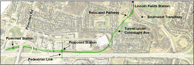
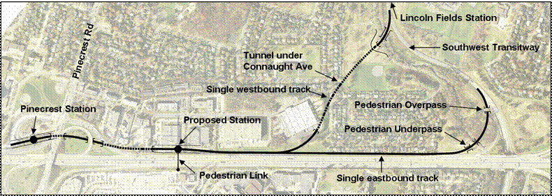
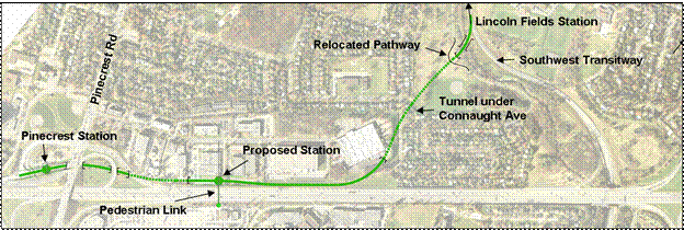
In 1996, the Ontario Ministry of Environment (MOE) approved the West Transitway Extension – Woodroffe Avenue to Acres Road Environmental Assessment study.  The eastern portion of the 1996 Recommended Plan (from the Southwest Transitway to Pinecrest Road) identified a grade-separated transitway on the north side of Highway 417 and is illustrated in Figure 1.  Beginning at the Southwest Transitway, this alignment proceeds west under the NCC open space and Connaught Park, Connaught Avenue and the OC Transpo garage via an approximately 400m cut and cover “tunnel.”  The transitway exits the tunnel just west of the OC Transpo garage and proceeds on the north side of Highway 417, with a station planned in the vicinity of existing commercial properties on Queensview Drive, before passing under the Pinecrest Road interchange.  Connection to the south side of Highway 417 at the Queensview Station would be provided by a new pedestrian bridge. 


Figure 1: West Transitway (Woodroffe Avenue to Pinecrest Road) 1994 EA Study – Alignment C


Alignment C


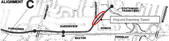
The tunnel section through the NCC open space near Connaught Avenue was recommended to mitigate impacts to the adjacent community and open space.  Following public consultations during the original EA study, the proposed tunnel was extended to the eastern limits of the Pinecrest Creek to preserve the NCC open space and reduce visual impact.  This solution requires the removal of three homes on Connaught Avenue that were subsequently purchased by the City and are currently rented.  In addition, a storm water pumping station is required to ensure that intense storms do not affect the transitway.


The western portion of the 1996 Recommended Plan from Pinecrest Road to Bayshore Station was constructed and has been in operation since 2009.


2008 Value Engineering Study


Under Council direction, the City completed a Value Engineering (VE) study in March 2008 to review the findings of the 1996 EA and to identify alternatives capable of reducing costs and increasing the value of the project for the eastern section (Southwest Transitway to Pinecrest Road).  As an initial step in the VE study, and using 2007 contract pricing, an updated cost for the recommended tunnel solution was estimated at $138M.  This cost was established as a baseline measure by which to compare alternative proposals.


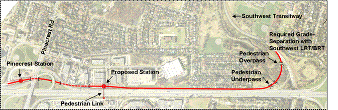
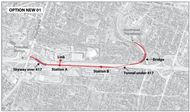
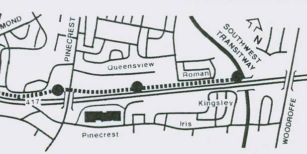
As a lower cost proposal, the VE study recommended revisiting Alignment A (Figure 2) from the 1996 EA which runs along the south side of Roman Avenue and requires removing 25 residential properties.  Due to the significant impact to the adjacent community, the 1996 EA study had previously reviewed and discarded Alignment a.  Notwithstanding community impacts, this alignment does lower capital costs by approximately $30M by eliminating the need to construct the 400 m long tunnel under the NCC open space near Connaught Avenue.


Figure 2: 1994 EA Study Alignment A – Parallel to Roman Avenue


WTE alignment A only.jpg


In addition to exploring potential alternatives for the segregated transitway, the VE study also identified opportunities to implement interim measures to maximize the efficiency of current transit operations within the Highway 417 corridor.


The VE study was a brief three-day brainstorming workshop and not a detailed analysis and evaluation of alternatives.  The purpose of the VE was to analyze functional requirements, generate and evaluate ideas, compare alternative value enhancements, and make recommendations for further study.  Following its completion in May 2008, Council received the VE Study and approved a motion to:


·         Undertake the purchase of homes from willing residents potentially affected by the alignment parallel to Roman Avenue.


See Document 1 for the complete version of this Council motion.


In response to the second directive, the Real Estate Partnerships and Development Office, Realty Services Branch, contacted the 25 affected owners of property listed on Schedule “A” in Document 1 in writing.  They were advised that the City would negotiate with the owner with a view to a City purchase of their property based on an independent appraisal of fair market value, and on a willing seller – willing buyer basis.  In total, written requests were received from seven property owners, among which ensuing negotiations with five of the owners resulted in accepted Agreements of Purchase and Sale that were closed between September 2008 and March 2009. These properties were subsequently advertised and rented for residential occupancy at market rates for a one year term, respectively, that since have expired but continue to be in effect on a month-to-month basis. These properties would remain in an interim tenancy until such time that removal of the dwellings was required in order for construction of the west transitway to proceed.


DISCUSSION


Status of Current Planning Study


Following the May 2008 Council direction, Council approved the scope of work for the West Transitway Extension (Southwest Transitway and Pinecrest Road) Planning and EA study.  This study had the following objectives:


·         Explore potential interim transit operational improvements within the Highway 417 corridor to improve the speed and reliability of current transit operations; and


·         Re-examine potential alternatives and confirm a Recommended Plan for the future exclusive, grade-separated BRT facility, capable of accommodating rail technology in the future.


Interim Transit Operational Improvements


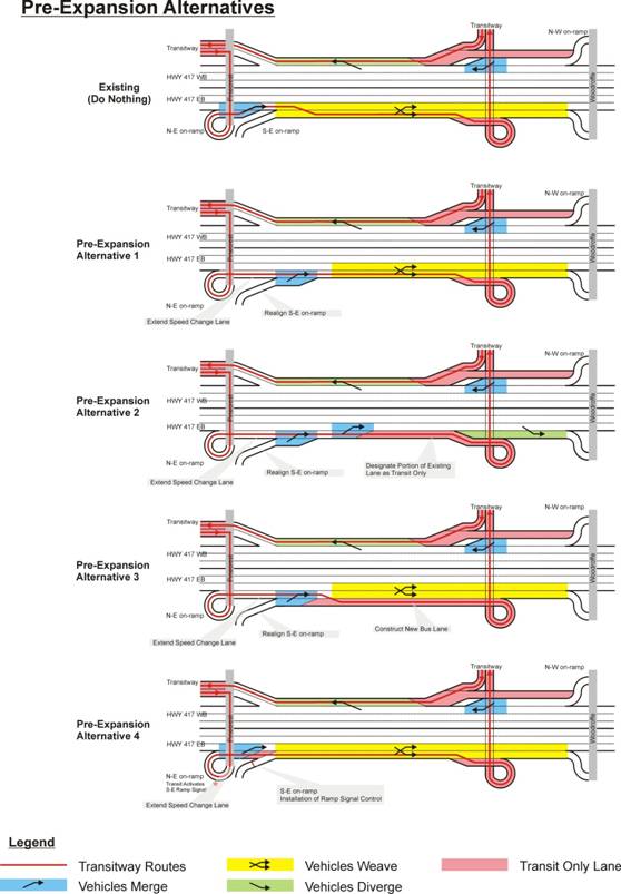
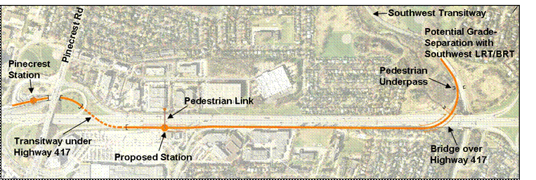
Under current conditions, buses travel in mixed traffic on Highway 417 between the Southwest Transitway and Pinecrest Road, resulting in unpredictable travel time and reduced service reliability.  Westbound buses travel on the auxiliary lane and are therefore generally isolated from mainline highway traffic congestion during peak periods.  In the eastbound direction however, significant delays occur during peak periods at the point where buses merge from the Greenbank on-ramp into mixed traffic on Highway 417.  Eastbound buses must then merge into the auxiliary lane into mixed traffic to gain access to the dedicated transit lane leading to Queensway Station.  Figure 3 illustrates current bus operations in the eastbound direction.


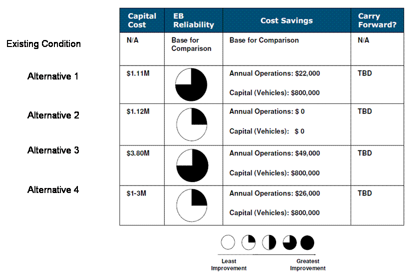
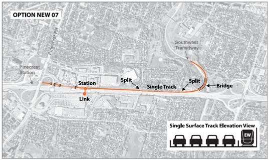
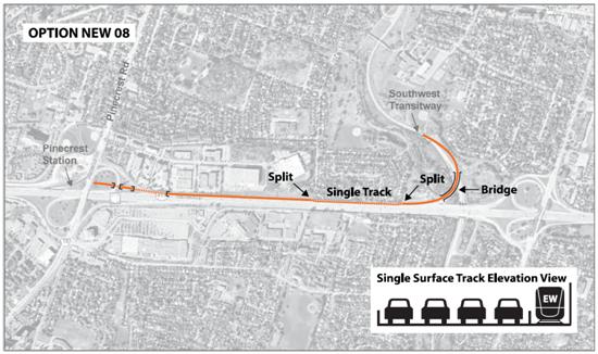
To improve current operations, this study has identified and assessed alternatives for interim transit operational improvements within the Highway 417 corridor that take into account MTO’s planned widening of this highway.  Alternatives were identified prior to as well as post widening of the highway.  These alternatives are generally low cost and easily implementable, and include, for example, ramp modifications, repurposing existing lanes, extending merge lanes, and extending reserved bus lane.  Schematic plans and details of these alternatives, including preliminary evaluations, are included in Document 2.


Pre-Widening of Highway 417 Alternative


As buses currently travelling in the westbound direction are generally isolated from mixed traffic, this study recommends continuing with current operations in the westbound direction.  Short term measures to improve buses travelling westbound were reviewed and required property and significant capital investment over a relatively short time frame.  These measures resulted in insignificant benefit, and given the large capital investment, it was therefore eliminated.


For buses travelling in the eastbound direction, this study identified a preferred alternative based on the results of the evaluation and subject to MTO approval.  The preferred alternative involves realigning the Greenbank S-E ramp and repurposing the N-E ramp so that it connects directly to the existing auxiliary lane.  Eastbound buses enter Highway 417 onto the N-E ramp and remain in this lane until reaching the dedicated transit lane leading to Queensway Station.  This improvement prioritizes transit operations by allowing buses to travel directly to the dedicated transit lane and eliminates having to merge twice into mixed traffic.  General traffic from the S-E on-ramp will be required to merge into the auxiliary lane and then merge again into mixed traffic on the highway prior to reaching the Woodroffe Avenue W-NS exit ramp.  A schematic of the preferred Alternative 1 is illustrated in Figure 3.


Figure 3: Illustration of Eastbound Bus Operations under Existing Conditions and Pre-Widened Highway Preferred Alternative


Existing & Preffered interim.jpg


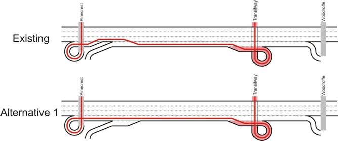
The capital cost of this alternative is in the order of $1.1M (unescalated).  Based on the scope of work, a Municipal Class EA “Schedule A+” process is required to complete this work and is within the scope of the current study.  This interim measure is consistent with MTO’s planned widening of the highway in that, once the highway is widened, this lane extension will become the fourth eastbound lane.


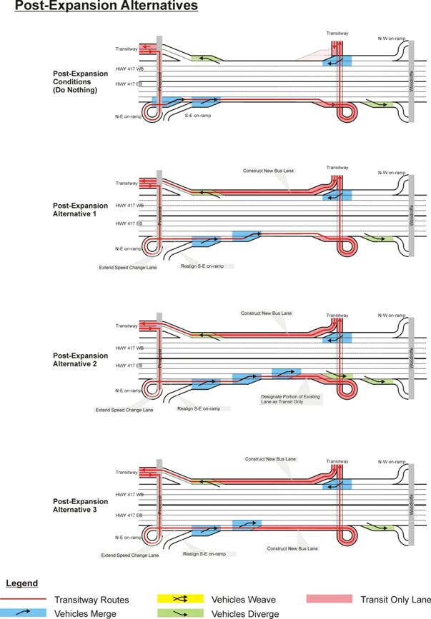
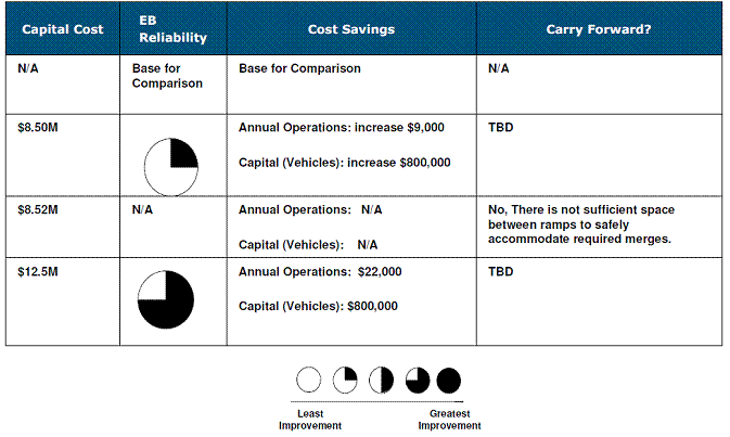
Post-widening of Highway 417


The MTO has an approved EA to widen Highway 417 to eight lanes from Highway 416 to Anderson Road.  Once the highway is widened between Pinecrest Road and Woodroffe Avenue, additional operational improvements will be required to maintain reliable transit service.


For the ultimate eight lane Highway 417 configuration, eastbound buses will be faced with the same operating conditions today, whereby buses will need to merge into mixed traffic.  To resolve these operational issues, the preferred alternative that was proposed earlier and noted in Figure 3 would also apply in this situation.


According to MTO’s Highway 417 Widening EA Study for the westbound direction, the current auxiliary lane, from the Southwest Transitway to Pinecrest Road, will be converted to the fourth lane of the highway.  In contrast with today’s operations, westbound buses will no longer have access to an auxiliary lane and will be required to merge into mixed traffic.  Alternative solutions proposed for the westbound direction involved the construction of a dedicated transit lane adjacent to the new fourth lane of Highway 417 (Document 2).  Although this additional transit lane is generally within MTO’s Highway 417 right of way, some residential property on the south side of Roman Avenue would be required, and for this reason, these alternatives will not be carried forward for further evaluation.


Transitway Corridor Evaluation


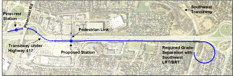
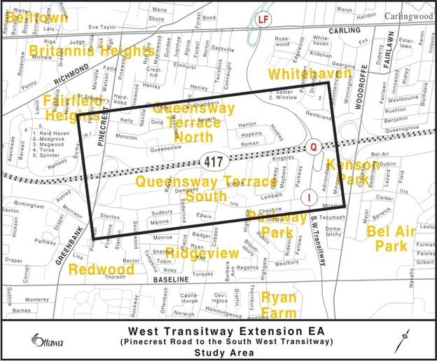
For the review and evaluation of alternative segregated transitway corridors, the study area is defined as the area north and south of the Highway 417 between the Southwest Transitway and Pinecrest Road, as illustrated in Figure 4.


Existing conditions in this area include the following:


·         An established residential and commercial community adjacent to the Highway 417 corridor on the north and south side.

·         NCC Pinecrest Creek corridor and open space bordering the Southwest Transitway complete with mature trees, recreational pathways and forest trails along the creek.

·         Connaught Park with a ball diamond adjacent to the NCC open space.

·         Significant underground municipal infrastructure (sewers and water mains) in the adjacent open space as well as towards Pinecrest Road.

·         OC Transpo bus garage at the end of Queensview Drive.


Figure 4: Planning and EA Study Area


WestTRWY_EA_Engl.jpg


In accordance with Council direction, the City approached the Ontario Ministry of Transportation and requested confirmation of the Ministry’s position regarding the possibility of converting existing highway lanes to bus-only lanes as a solution for the long-term, exclusive BRT corridor.  In response to this request, MTO indicated a willingness “to work with the City to explore options that would use portions of the Highway right-of-way to improve transit operations, but would stop short of affecting the current or proposed lanes on Highway 417, including Reserved Bus Lanes (RBLs) and other measures.”


Accordingly, a list of potential alternative alignments were identified for the transitway facility that did not affect MTO lanes, although given the highly constrained nature of the area, no new viable concepts were identified.  In view of the fact that alternatives had been extensively explored through the previous 1996 EA and the aforementioned VE Study, none of these current potential alignments were considered fundamentally improved.  Of the six alternatives identified, five represented a refinement of previously considered alternatives that were updated to accommodate current design standards and future operational requirements, including future conversion to LRT.  The sixth alignment represented a hybrid of two previous alternatives, by using separate alignments for eastbound and westbound services in order to minimize the footprint in any one area. 


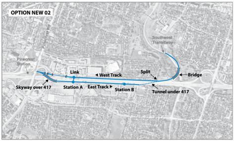
Using the 1996 Plan as a baseline measure, criteria for evaluating the list of current alternative concepts included reducing costs, environmental impacts, and impacts to the adjacent community.   Based on this screening, only Alignment A – Roman Avenue was identified as having potential benefits in reducing capital costs, when compared to the 1996 Plan (Figure 5). However, significant disadvantages to this alignment include:


·         This alternative requires removing 25 homes on Roman Avenue (five of which have been purchased by the City), and has met tremendous resistance from residents.


·         To be compatible with rail technology, the plan parallel to Roman Avenue introduces a new “S” curve with relatively small radius, and has significant negative impact on travel time, and increases operating and maintenance issues.


·         The connection with the Southwest Transitway requires an elevated Transitway facility (“fly-over”) extending over Pinecrest Creek and will result in visual intrusion to the Whitehaven community on the east side of the Southwest Transitway.  Also a significant footprint is required for this alternative.


·         Furthermore, this alternative is not consistent with the direction from Council to explore alternatives “that do not require the demolition of homes.”


Figure 5 – Refined Alignment A from the 1996 Approved EA


Alternative 1 - Our Labels


Recognizing these disadvantages, staff continues to recommend this alignment not be carried forward for further study.  Details and preliminary evaluation of the six alternatives are included in Document 3.


Alternatives Submitted by the Queensway Terrace North Community Association


In addition, at the second Public Open House held in December 2010, the Queensway Terrace North Community (QTNC) Association presented for consideration eight additional alternative concepts for the long-term exclusive rapid transit corridor.  These new alternative concepts were assessed by staff using the same criteria as the other alternative concepts, and specifically, on their technical and operational feasibility and their ability to reduce impacts when compared to the 1996 Plan.  After extensive evaluation, and following discussion of the results with the QTNC, none of the eight alternatives were carried forward for further consideration.


To be considered technically feasible, an alternative must be physically capable of accommodating geometric requirements for BRT with the ability for conversion to light rail transit (LRT) in the future.  To determine feasibility, geometric constraints in the corridor were identified and appropriate geometric standards were applied to each QTNC alternative.  Conflicts were identified and noted.  Of the eight alternatives presented, only QTNC Option 4 was deemed technically feasible, although at a high cost and high property impact.  This alternative involved a shift in the alignment of Highway 417 to accommodate an adjacent transitway, reconstructing the mainline highway from Woodroffe Avenue to Pinecrest Road including the adjacent interchanges, significantly disrupting highway operations, and resulting in the removal of residential properties on the south side of the Highway 417.  As this alignment was not considered an improvement over the 1996 Plan, it was therefore not carried forward for further consideration.  Evaluation of these eight alternatives is included in Document 4.


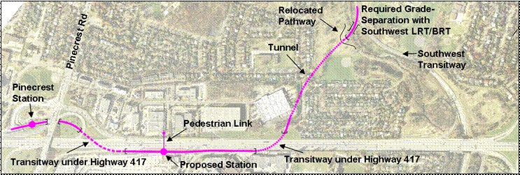
The analysis of potential transitway corridor alternatives completed during this study confirms that there are no improved alternative concepts to the 1996 EA Approved Plan (Figure 6).


Figure 6 – Refined 1996 EA Approved Plan

Approved Plan - Our Labels.png


Planning Study Recommendation


At this stage, there appears to be no merit in proceeding further with the transitway corridor planning component of this study for the following reasons:


·         The Recommended Plan (Alignment C) from the 1996 approved EA remains valid today and has no expiry date with respect to the EA process as it was conducted as an Individual EA.


·         The analysis of 14 alternative concepts concluded that there are no new and improved technically feasible alternatives, as compared to the 1996 Plan, and according to Council direction, “that do not require the demolition of homes.”


·         MTO has confirmed that, while they are willing to work with the City to explore options that would use portions of the Highway right-of-way to improve transit operations, these options must not affect the current or proposed lanes on the Highway 417, including Reserved Bus Lanes and other measures.


Accordingly, staff recommend the following:


·         Terminating the transitway corridor component of the study and reverting back to the 1996 EA Approved Plan.


·         Terminating the direction from Council to purchase the residential properties affected from the re-assessment of the proposed transitway corridor on the south side of Roman Avenue as this plan does not require residential properties along Roman Avenue.


·         Approving the preferred interim alternative within the Highway 417 corridor, prior to the Highway widening, to improve current transit operations. 


·         Implementing the preferred interim alternative within the Highway 417, subject to MTO approval, since the segregated transitway facility is not expected to be implemented until near the end of the planning horizon.


CONSULTATION


A comprehensive stakeholder engagement program was developed including two Agency and Public Consultation Group (ACG and PCG) meetings, two Public Open Houses, a Community Site Walk and a Bus Tour.  Included in the PCG were the Chairs from each of the Accessibility Advisory Committee and the Seniors Advisory Committee to represent the accessibility interests and issues.


Open House #1


The first Public Open House (POH) was held in May 2010 with the objective of introducing the study, presenting the proposed study process, and providing the public with an opportunity to review and comment on the project objectives, public consultation process, existing conditions, previously considered alternatives, and the next steps in the study.


The POH was well attended with 97 people signing the register. Eighteen comments were submitted either by comment sheet or email. The majority of comments received pertained to respondents’ preferred location for the transitway through the study area.  While new design alternatives were not presented at this open house session, respondents reacted to the alternative routes that had previously been considered during the 1996 EA.  Some respondents also indicated potential concerns, including impacts to property, greenspace, and noise.


Open House #2


The second POH was held in December 2010 with the objective of explaining potential transit operational improvements (pre- and post-highway expansion) within the Highway 417 corridor and presenting the preliminary re-examination of alternatives for the exclusive rapid transit corridor, for bus and light rail.


Materials that were displayed and presented at the open house included: study purpose and objectives, vision and guiding principles, planning context and EA process, existing transit services and project constraints, alternatives for near term transit operational improvements, alternatives for the ultimate exclusive rapid transit corridor, evaluation process, and project status and milestones.  In addition, the QTNC presented eight additional concepts for the segregated transitway for consideration.  A total of 52 people signed the POH registry and 20 respondents submitted input via comment sheets or by email.  In general, respondents expressed concern with potential impacts to Connaught Park and Roman Avenue and some supported the options proposed by the QTNC.  Several respondents also suggested that the City should skip the BRT phase of this project and proceed directly to LRT and in the interim, implement the low cost operational improvements within the Highway 417 corridor.


Community Site Walk


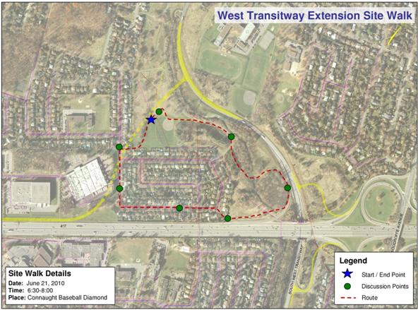
The community site walk was held in June 2010 with 16 participants, made up of representative members of the PCG and ACG and four members of the Project Team. The purpose of the site walk was to provide another venue and context for advisory committee members to articulate specific issues and concerns within the immediate setting of the study area.


Issues that were discussed during the site walk included significant trees that may be affected by the design proposals, property ownership (NCC versus City owned lands), Pinecrest Creek restoration, the future of Highway 417 station, the approved 1996 EA Plan, the potential impact to properties along Roman Avenue, MTO’s approved Highway 417 Expansion EA, and the future of the OC Transpo garage.


Community OC Transpo Bus Tour


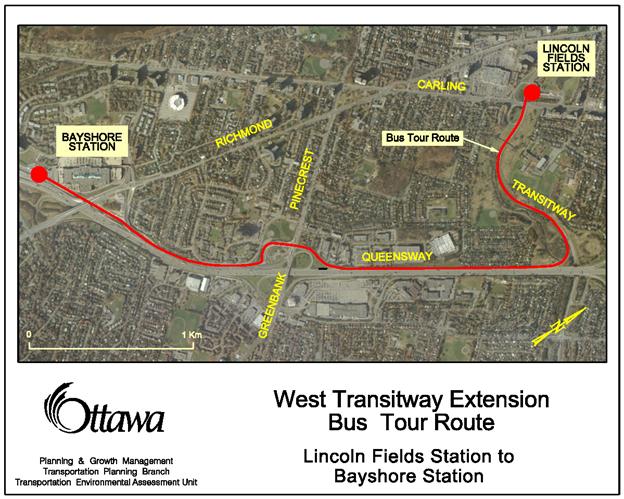
In November 2011 the City’s Project Manager and interested members of the community traveled on the existing transitway between Lincoln Fields and Bayshore Station.  The purpose of this trip was to develop a collective understanding of current challenges associated with the operation of transit services in mixed traffic on Highway 417.  General comments included the immediate implementation of low cost operational improvements within the Highway as this avoids any impact to the community.


A summary of the public consultations and comments received is included in Document 5.


COMMENTS BY THE WARD COUNCILLORS


Councillor Taylor was consulted on this report and provided the following comments:


“I am in full support of this report which sees the pathway of the western transitway BRT/LRT corridor from Lincoln Fields returned to the approved 1996 EA route that uses a short tunnel beneath Connaught Park.


This is significant to our Queensway Terrace North Community because:


- it will save 25 family homes, including Ottawa's first Habitat for Humanity home, from expropriation and demolition


- it will end the city home purchase arrangement on Roman Avenue and ensure that we continue to receive taxation revenues from these 25 homes in years to come


- it will end 25 years of stress and anxiety in this Neighbourhood and return home values to normal market value


For transit users the return to the 1996 alignment is valuable because:


- it makes for a shorter, potentially faster route. A straight line between two points with few turns and curves, with no residential impact and no need for a costly flyover structure to be built


I am hopeful that the Committee understands the value of this report to our west end community and approves it for recommendation to Council.”


Councillor Chiarelli was consulted on this report and indicated that he supports keeping the extension on the north side of the Queensway.


LEGAL IMPLICATIONS


There are no legal impediments to implementing the recommendations in this report.


RISK MANAGEMENT IMPLICATIONS


N/A


CITY STRATEGIC PLAN


The recommendations contained herein aims to support the following Strategic Directions adopted by Council:


Transportation and Mobility


TM1: Ensure sustainable transit services.

TM3: Provide infrastructure to support mobility choices.

TM4: Promote alternative mobility choices.


TECHNICAL IMPLICATIONS


N/A


FINANCIAL IMPLICATIONS


The report indicates that an investment of approximately $1.1M (subject to escalation) will provide sufficient interim measures to address the Southwest Transitway to Pinecrest Road transit corridor operational issues.


Funding would be redirected from the unspent authority in Capital Project # 903274, which has an unspent balance of $2.2M at September 30, 2011.   This Capital Project account was established for the Planning and EA study related to the corridor in addition to the acquisition of several properties proposed by a 2008 Value Engineering study related to the corridor investment.  However, only a minority of the properties have been acquired voluntarily to date and it would appear that this approach is not in no longer feasible. 


The current proposal appears to be the more affordable alternative and there remains sufficient capital authority to fund the interim investment.


ACCESSIBILITY IMPACTS


For this Planning and EA study, the Chair from each of the Accessibility and Advisory Committee and the Seniors Advisory Committee were included in all communication and public consultation sessions to represent the interests and provide comments and feedback on accessibility issues.  All accessibility features will be considered during the implementation of this Transitway corridor facility in accordance with the Accessibility for Ontarians with Disabilities Act. 


SUPPORTING DOCUMENTATION


Document 1    14 May 2008 Council Approved Motion

Document 2    Description and Preliminary Analysis of Alternative Operational Improvements

Document 3    Alternative Solutions for the Transitway Corridor and Preliminary Evaluation

Document 4    Queensway Terrace North Community List of Alternative Solutions and Preliminary Evaluation

Document 5    Summary of Public Consultations, Comments and Feedback


DISPOSITION


Subject to Council approval of the recommendations, Transportation Planning Branch will terminate the transitway corridor evaluation component of the West Transitway Extension – Southwest Transitway to Pinecrest Road Planning and EA study, and proceed with finalizing the interim operational improvements within the Highway 417 corridor, prior to the widening of the Highway.  Following this, Infrastructure Services Department will implement these interim operational improvements subject to the City’s Purchasing By-Law.


Furthermore, the Real Estate Partnerships and Development Office will suspend the acquisition program for affected properties listed on Schedule “A” in Document 1.


14 MAY 2008 COUNCIL APPROVED MOTION                                            DOCUMENT 1


On 14 May, 2008 Council approved the following motion in reference to the West Transitway Extension (Southwest Transitway to Pinecrest Road) Value Engineering Study Recommendations (ACS2008-PTE-PLA-0058)


AND WHEREAS that report recommends an environmental assessment to study an alternative route along the Highway 417 right-of-way;


AND WHEREAS this alternative may impact approximately 25 homes on the south side of Roman Avenue, creating hardship for those who may wish to sell their homes in the interim and receive fair market value;


AND WHEREAS pursuant to the Environmental Assessment Act the City may, prior to receiving EA approval, acquire property or rights in property in connection with a project which is the subject of the EA;


THEREFORE BE IT RESOLVED THAT the Transit Committee recommend to City Council that:


a.       staff be directed to provide notice to the Owners of the properties listed on Schedule “A” to this Motion that the City will consider requests by Owners that the City purchase their property;


b.      where requested in writing by an Owner to do so, staff will negotiate with the Owner with a view to a City purchase of the property;


c.       the negotiations are to be based on an independent appraisal of fair market value, and on a willing seller-willing buyer basis;


d.      where staff is satisfied that a fair market value price has been agreed upon, the City will purchase that property, subject to the acquisition approval process applicable to the purchase (Council or delegated Authority); and


e.       acquisitions of any properties listed on Schedule “A” be funded from the Transit Capital Reserve.


2496 Roman Avenue

2500 Roman Avenue

2506 Roman Avenue

2512 Roman Avenue

2514 Roman Avenue

2516 Roman Avenue

2522 Roman Avenue

2526 Roman Avenue

2532 Roman Avenue

2536 Roman Avenue

2540 Roman Avenue

2542 Roman Avenue

2546 Roman Avenue

2550 Roman Avenue

2554 Roman Avenue

2558 Roman Avenue

2562 Roman Avenue

2570 Roman Avenue

2576 Roman Avenue

2580 Roman Avenue

2584 Roman Avenue

2588 Roman Avenue

2592 Roman Avenue

2596 Roman Avenue

and 1063 Hindley Avenue


DESCRIPTION AND PRELIMINARY ANALYSIS

OF ALTERNATIVE OPERATIONAL IMPROVEMENTS                           DOCUMENT 2


Preliminary Evaluation of Pre-Expansion Alternatives


Preliminary Evaluation of Post-Expansion Alternatives


Alternative 1


Alternative 2


Alternative 3


Existing Condition


Alternative Solutions for the Transitway

Corridor and Preliminary Evaluation                                                                     DOCUMENT 3


Alternative

Advantages

Disadvantages

Screening Criteria

Carry Forward?

Q1 - Can the alternative physically accommodate geometric requirements for exclusive BRT and future LRT?

(See Table 2)

Q2 – Does the alternative have the potential to reduce impacts when compared to the 1996 Plan?

Alternative 1 - 1996 EA Recommended Plan (Alignment C from 1996 EA)


         Relatively straight geometry results in increased operating speed and improved ride comfort

         The tunnel concept limits impacts to residential property (removal of 3 city-owned properties on Connaught Avenue)


       The east tunnel portal impacts the Pinecrest Creek corridor and Connaught Park

       The tunnel under Connaught Avenue carries a structural cost of approximately ~ $38M and potentially impacts underground utilities.

ü

Yes


N/A

ü


Approved Plan - Our Labels


Alternative

Advantages

Disadvantages

Screening Criteria

Carry Forward?

Q1 - Can the alternative physically accommodate geometric requirements for exclusive BRT and future LRT?

(See Table 2)

Q2 – Does the alternative have the potential to reduce impacts when compared to the 1996 Plan?

Alternative 2 (Alignment A from 1996 EA)


         Reduced cost by avoiding grade separation of Connaught Avenue

         At grade concept limits underground utility conflicts

         Directly adjacent to transportation corridor

         Contains impacts to within existing impacted area of Pinecrest Creek corridor (i.e. in vicinity of existing highway crossing)

       Increased impact to residential properties (removal of 24 properties on Roman Avenue)

       The 150 m radius curve results in longer travel distance, lower operating speed and potential for reduced ride comfort.


ü

Yes


ü This alternative minimizes the requirement for a costly tunnel under Connaught Avenue, contains impacts within existing impacted area of Pinecrest Creek (i.e. in vicinity of existing Highway 417 crossing), and locates the facility adjacent to the existing transportation corridor. While it does result in increased property impacts, this alternative has the potential to reduce overall impacts associated with the 1996 Recommended Plan. These tradeoffs require further analysis.

ü


Alternative 1 - Our Labels


Alternative

Advantages

Disadvantages

Screening Criteria

Carry Forward?

Q1 - Can the alternative physically accommodate geometric requirements for exclusive BRT and future LRT?

(See Table 2)

Q2 – Does the alternative have the potential to reduce impacts when compared to the 1996 Plan?

Alternative 3 (Alignment B from 1996 EA)


         Contains impacts to within existing impacted area of Pinecrest Creek corridor (i.e. in vicinity of existing highway crossing)

         Avoids impact to Connaught Park

       Greatest impact to residential properties (removal of ~ 85 properties on Kingsley, Adirondack, Minnetonka)

       Tunnel under the highway will disrupt highway operations during construction and increase capital cost

ü

Yes


O This alternative results in increased property impacts and increased capital cost due to the requirement for a costly and disruptive tunnel under the Queensway. As any proposed station will link both sides of the highway via a new pedestrian bridge, there is no advantage to providing a station on the south side. This alternative therefore does not have the potential to reduce impacts when compared with the 1996 Recommended Plan and should not be carried forward for further consideration.

O


Alternative 2 - Our Labels


Alternative

Advantages

Disadvantages

Screening Criteria

Carry Forward?

Q1 - Can the alternative physically accommodate geometric requirements for exclusive BRT and future LRT?

(See Table 2)

Q2 – Does the alternative have the potential to reduce impacts when compared to the 1996 Plan?

Alternative 4 (Alignment D from 1996 EA)


         Tunnel concept limits impacts to residential property (removal of 3 city-owned properties on Connaught Avenue)


       Two tunnels under Highway 417 will result in significant highway disruptions and increased cost.

       East tunnel portal impacts Pinecrest Creek corridor and Connaught Park

       The grade-separation of Connaught Avenue increases capital cost and results in potential impact to utilities

ü

Yes


O This alternative requires two additional highway grade separations that will result in significantly higher costs and disruptions to highway operations. As any proposed station will link both sides of the highway via a new pedestrian bridge there is no advantage to providing a station on the south side. This alternative therefore does not have the potential to reduce impacts when compared with the 1996 Recommended Plan and should not be carried forward for further consideration.

O


Alternative 3 - Our Labels


Alternative

Advantages

Disadvantages

Screening Criteria

Carry Forward?

Q1 - Can the alternative physically accommodate geometric requirements for exclusive BRT and future LRT?

(See Table 2)

Q2 – Does the alternative have the potential to reduce impacts when compared to the 1996 Plan?

Alternative 5 (Alignment E from 1996 EA)


         Contains impacts to within existing impacted area of Pinecrest Creek corridor (i.e. in vicinity of existing highway crossing)

         Avoids impacts to Connaught Park


       Two highway grade separations result in increased capital cost, potential visual intrusion and disruption to highway operations.

       Increased impact to residential properties (removal of ~ 34 properties on Kingsley)

ü

Yes


O This alternative results in increased property impacts. It also results in increased capital cost and disruptions to highway operations due to the requirement for two highway grade separations. As any proposed station will link both sides of the highway via a new pedestrian bridge, there is no advantage to providing a station on the south side. This alternative therefore does not have the potential to reduce impacts when compared with the 1996 Recommended Plan and should not be carried forward for further consideration.

O


Alternative 4 - Our Labels


Alternative

Advantages

Disadvantages

Screening Criteria

Carry Forward?

Q1 - Can the alternative physically accommodate geometric requirements for exclusive BRT and future LRT?

(See Table 2)

Q2 – Does the alternative have the potential to reduce impacts when compared to the 1996 Plan?

Alternative 6 (New Concept)

         Potentially reduces required tunnel cross-section and therefore reduces tunnel costs

         Limited impact to residential property (removal of three city-owned properties on Connaught).

       The provision of two separate corridors (EB and WB) increases operating and maintenance costs and results in a larger facility footprint.

O No, a single lane tunnel does not provide sufficient cross-section width to facilitate passing of a disabled bus.

N/A

O


Alternative 5- Our Labels


Queensway Terrace North Community List of

Alternative Solutions and Preliminary Evaluation                                     DOCUMENT 4


Alternative

Advantages

Disadvantages

Screening Criteria

Carry Forward?

Q1 - Can the alternative physically accommodate geometric requirements for exclusive BRT and future LRT?

(See Table 2)

Q2 – Does the alternative have the potential to reduce impacts when compared to the 1996 Plan?

QTNC Option 1


         Contains impacts to within existing impacted area of Pinecrest Creek corridor (i.e. in vicinity of existing highway crossing)

         Avoids Connaught Park

         No loss of residential properties

        While this alternative avoids the requirement to tunnel under Connaught Avenue and shortens the underpass structure at the west project limit, the following proposed grade separations will result in significant highway disruptions and increased structural costs (~$30M more than 1996 approved Connaught Tunnel plan):

            270 m tunnel under Highway 417 in the east;

            500m bridge over SW Transitway and Pinecrest Creek; and

            460 m bridge over Highway 417 in west.

        There is insufficient vertical clearance at Pinecrest Road and west bound on-ramp at Pinecrest Road interchange

        There is insufficient clearance for the proposed crossing under Highway 417 at the east limit.

O No, there is insufficient vertical clearance at Pinecrest Road, the west bound on-ramp at Pinecrest Road, and the proposed highway crossing west of the Southwest Transitway. Due to significant geometric constraints, this alternative is not considered technically feasible. (See Table 2 and attached plan and profile for details regarding geometric constraints).

N/A

O


Alternative

Advantages

Disadvantages

Screening Criteria

Carry Forward?


Q1 - Can the alternative physically accommodate geometric requirements for exclusive BRT and future LRT?

(See Table 2)

Q2 – Does the alternative have the potential to reduce impacts when compared to the 1996 Plan?


QTNC Option 2


         Contains impacts to within existing impacted area of Pinecrest Creek corridor (i.e. in vicinity of existing highway crossing)

         Avoids impacts to Connaught Park

         No loss of residential properties

        A single lane configuration would introduce a significant bottleneck in the rapid transit network and does not accommodate the operation of buses in the corridor.

        The provision of two separate corridors (EB and WB) increases operating and maintenance costs and results in a larger facility footprint.

        There is insufficient clearance for the proposed crossing under Highway 417 at the east limit

        While this alternative avoids the requirement to tunnel under Connaught Avenue the following proposed grade separations will result in significant highway disruptions and increased structural costs (~$40M more than 1996 approved Connaught Tunnel plan):

            420 m tunnel under Highway 417 and a portion of Roman Avenue at the east project limit;

            500m bridge over SW Transitway and Pinecrest Creek; and

            460 m bridge over Highway 417 at the west project limit.

O No, for BRT a single lane configuration does not provide sufficient cross-section width to enable the passing of a disabled bus. There is also insufficient clearance to accommodate the proposed tunnel under Highway 417 at the west end of the study limits. Due to significant geometric constraints, this alternative is not considered technically feasible.

N/A

O


Alternative

Advantages

Disadvantages

Screening Criteria

Carry Forward?


Q1 - Can the alternative physically accommodate geometric requirements for exclusive BRT and future LRT?

(See Table 2)

Q2 – Does the alternative have the potential to reduce impacts when compared to the 1996 Plan?


QTNC Option 3


         Contains impacts to within existing impacted area of Pinecrest Creek corridor (i.e. in vicinity of existing highway crossing)

         Avoids Connaught Park

         No loss of residential properties

        There is insufficient clearance for the proposed crossing under Highway 417 at the east limit

        While this alternative avoids the requirement to tunnel under Connaught Avenue, the following proposed grade separations will result in significant highway disruptions and increased structural costs (~$25M more than 1996 approved Connaught Tunnel plan):

            270 m tunnel under Highway 417 in the east; and

            500m bridge over SW Transitway and Pinecrest Creek.

        Diagonal crossings under highway (south to north) would make staging construction difficult and would result in significant disruptions to highway operations

        Potential impact to major underground utilities (collector sewers) crossing highway

O No, there is insufficient clearance under the highway at the proposed crossing west of the Southwest Transitway. Due to significant geometric constraints, this alternative is not considered technically feasible. (See Table 2 and attached plan and profile for details regarding geometric constraints).

N/A

O


Alternative

Advantages

Disadvantages

Screening Criteria

Carry Forward?


Q1 - Can the alternative physically accommodate geometric requirements for exclusive BRT and future LRT?

(See Table 2)

Q2 – Does the alternative have the potential to reduce impacts when compared to the 1996 Plan?


QTNC Option 4


         Contains impacts to within existing impacted area of Pinecrest Creek corridor (i.e. in vicinity of existing highway crossing)

         Avoids Connaught Park

        Shifting Highway 417 south by one lane will require the realignment of the highway from west of Pinecrest Road to east of Woodroffe Avenue due to required design criteria for highway speeds

        This highway realignment will impact the on/off ramps at Pinecrest Road and Woodroffe Avenue and will require the reconstruction of these interchanges

        The realignment will impact piers of the Pinecrest Road and Woodroffe Avenue overpass structures, requiring them to be reconstructed

        The realignment will impact the Transitway underpass structure and require the structure to be modified

        Property on south side of highway will be required to accommodate the realignment (impacts to ~34 properties on Kingsley Road).

ü Yes, however, by shifting the highway south by one lane, there would be significant conflicts with the existing highway structures and interchanges at Pinecrest Road and Woodroffe Avenue (interchanges would require reconstruction). (See Table 2 and attached plan and profile for details regarding geometric constraints).

O No, this alternative would require the reconstruction of highway interchanges (ramps and structures) as well as the mainline highway. This shift would impact the residential properties on the south side of Highway 417 and would result in significant disruptions to highway operations.  Due to the magnitude of required reconstruction, this alternative would be most costly to construct. This alternative therefore does not have the potential to reduce overall impacts when compared to the 1996 Recommended Plan and should not be carried forward for further consideration.

O


Alternative

Advantages

Disadvantages

Screening Criteria

Carry Forward?


Q1 - Can the alternative physically accommodate geometric requirements for exclusive BRT and future LRT?

(See Table 2)

Q2 – Does the alternative have the potential to reduce impacts when compared to the 1996 Plan?


QTNC Option 5


         Contains impacts to within existing impacted area of Pinecrest Creek corridor (i.e. in vicinity of existing highway crossing)

         Avoids Connaught Park

         No loss of residential properties

        While this alternative avoids the requirement to tunnel under Connaught Avenue the following proposed grade separations will result in significant highway disruptions and increased structural costs (~$50M more than 1996 approved Connaught Tunnel plan):

            920m, 2 lane tunnel under Highway 417 WB lanes; and

            500m bridge over SW Transitway and Pinecrest Creek.

        The reduction in the westbound lanes (one or two lanes) for an extended period of time to allow the safe construction of the tunnel would result in significant highway disruptions

        This alternative would impact major underground utilities (collector sewers) crossing Highway 417.

        There is there is insufficient clearance under the highway (and over Pinecrest Creek) at the east limit to construct the Transitway under the west bound lanes without impacting properties on Roman Avenue.

O No, there is insufficient clearance under the highway (and over Pinecrest Creek) at the east limit to construct the Transitway under the west bound lanes without impacting properties on Roman Avenue. (See Table 2 and attached plan and profile for details regarding geometric constraints).

N/A

O


Alternative

Advantages

Disadvantages

Screening Criteria

Carry Forward?

Q1 - Can the alternative physically accommodate geometric requirements for exclusive BRT and future LRT?

(See Table 2)

Q2 – Does the alternative have the potential to reduce impacts when compared to the 1996 Plan?

QTNC Option 6


         Contains impacts to within existing impacted area of Pinecrest Creek corridor (i.e. in vicinity of existing highway crossing)

         Avoids Connaught Park

         No loss of residential properties

        A single lane introduces a significant bottleneck in the bus rapid transit network as it does not provide sufficient cross-section width to enable the passing of a disabled bus.

        While this alternative avoids the requirement to tunnel under Connaught Avenue, the following proposed grade separations will result in significant highway disruptions and increased structural costs (~$20M more than 1996 approved Connaught Tunnel plan):

            920m, single lane tunnel under Highway 417 WB shoulder; and

            500m bridge over SW Transitway and Pinecrest Creek.

O No, for BRT, a single lane tunnel does not provide sufficient cross-section width to enable the passing of a disabled bus.  For LRT, a single track configuration cannot accommodate planned system capacity.


N/A

O


Alternative

Advantages

Disadvantages

Screening Criteria

Carry Forward?

Q1 - Can the alternative physically accommodate geometric requirements for exclusive BRT and future LRT?

(See Table 2)

Q2 – Does the alternative have the potential to reduce impacts when compared to the 1996 Plan?

QTNC Option 7


         Contains impacts to within existing impacted area of Pinecrest Creek corridor (i.e. in vicinity of existing highway crossing)

         Avoids Connaught Park

         No loss of residential properties

       This alternative does not accommodate BRT.

       A feasibility review of implementing a single track (bi-directional) LRT facility adjacent to Roman Avenue concluded that this configuration would not support the required capacity for the LRT system in 2031 and beyond, and would impose significant operational constraints and system costs for throughout the life of the facility. *

O No, this alternative does not accommodate BRT. Furthermore, a single track configuration cannot accommodate planned LRT system capacity.


N/A

O


Alternative

Advantages

Disadvantages

Screening Criteria

Carry Forward?

Q1 - Can the alternative physically accommodate geometric requirements for exclusive BRT and future LRT?

(See Table 2)

Q2 – Does the alternative have the potential to reduce impacts when compared to the 1996 Plan?

QTNC Option 8


         Contains impacts to within existing impacted area of Pinecrest Creek corridor (i.e. in vicinity of existing highway crossing)

         Avoids Connaught Park

         No loss of residential properties

       This alternative does not accommodate BRT.

       A feasibility review of implementing a single track (bi-directional) LRT facility adjacent to Roman Avenue concluded that this configuration would not support the required capacity for the LRT system in 2031 and beyond, and would impose significant operational constraints and system costs for throughout the life of the facility. *

O No, this alternative does not accommodate BRT. Furthermore, a single track configuration cannot accommodate planned LRT system capacity.


N/A

O


SUMMARY OF PUBLIC CONSULTATIONS,

COMMENTS AND FEEDBACK                                                                        DOCUMENT 5


Public Open House  #1


The first Public Open House (POH) was held on May 3, 2010 with the objective of introducing the study, presenting the proposed study process, and providing the public with an opportunity to review and comment on the project objectives, public consultation process, existing conditions, previously considered alternatives, and the next steps in the study. The Agency Consultation Group (ACG) and the Public Consultation Group (PCG) were consulted prior to the POH and their input was incorporated in the POH presentation.


Materials that were displayed and presented at the open house included: chronology of events leading to the current planning study, background information (including previous studies), planning context, proposed study process, study guiding principles, proposed consultation process, and project milestones.

The POH was well attended with 97 people signing the register. Eighteen comments were submitted either by comment sheet or email.  Refer to Table 1 for the POH summary of comments. The key findings are:


·         Majority of comments received pertained to respondents’ preferred location for the Transitway through the study area. 

·         While new design alternatives were not presented at this open house session, respondents reacted strongly to the alternative routes that had previously been considered during the 1996 IEA. 

·         Respondents provided comments on the consultation process and suggestions for improvement.

·         Some respondents indicated potential concerns, including impacts to property, greenspace, and noise.


Table 1: Summary of Comments from POH#1


Issues/Concerns/Comments Raised

Response Frequency

1.0 Design Suggestions

1.1

Support using the Queensway for Transitway buses as it keeps noise and traffic within the highway corridor.

4

1.2

Do not support the construction of a bus-only rapid transit corridor through Connaught Avenue or on Roman Avenue. Would prefer the immediate implementation of LRT.

2

1.3

Implement the tunnel option recommended in the 1996 IEA as this is the most fair and efficient option.

1

1.4

If LRT implementation is immediate, prefer an LRT alignment along Roman Avenue over a tunnel at Connaught Avenue.

1

1.5

Alternatives that infringe on greenspace (Alternatives C, D and E presented at the POH) are unacceptable.

1

1.6

Any transit stop considered for this project should be a small drop-off point for passengers and not a major station or transit hub.

1

1.7

Support a transit station on the south side of the Queensway at Pinecrest Road.

1

1.8

Do not support the construction of a tunnel.

1

2.0 Consultation Process

2.1

Affected residents should be provided with more detailed information (e.g. plans of the proposed options) in advance of public meetings.

3

2.2

Requested web access to information presented at the open house, including alignment alternatives.

3

2.3

Support proposed consultation process.

2

2.4

Would like to become part of the Public Consultation Group.

2

2.5

Request to be added to the study mailing list.

2

2.6

Concern that the only way to access additional project information is via the internet but there are many community members who do not regularly use the internet.

1

2.7

Was given little notice of POH and found the meeting room difficult to locate.

1

2.8

Purpose of presentation was somewhat unclear and perhaps misunderstood by the audience. Consider using less technical terms in the future (e.g. “option” instead of “alignment”).

1

2.9

Appreciated the clear explanation of the difference between the roles and responsibilities of Council and City Staff in conducting studies and making decisions.

1

2.10

Following the presentation, received the impression that Alignment C was the preferred plan as it was left up for most of the presentation.

1

3.0 Concerns/Potential Impacts

3.1

Noise levels are increasing and will increase further if the Transitway is located within the Queensway corridor. A noise barrier is required for the community north of the Queensway.

2

3.2

Minimum amount of greenspace (including NCC land, public parks, and bike paths) should be used for this project.

2

3.3

Consider increasing the amount of plantings (trees and bushes) to mitigate carbon dioxide emissions and to provide additional noise attenuation.

1

3.4

Concern about impacts to property value.

1

3.5

The time savings for this project will be minimal compared to the status quo.

1

3.6

Is the proposed expropriation of homes along Roman Avenue postponed, or is there a new plan in effect?

1

3.7

Will properties on Kingsley Road (parallel to Queensway, on the south side) be affected by this project?

1

3.8

Concerned about the potential impacts (noise and bus fumes) associated with the continued operation of the OC Transpo garage at Queensview Drive following the implementation of the West Transitway Extension.

1

4.0 Study Process

4.1

This study is dependent on outcome of the Western LRT Study and should be delayed until the Western LRT Study is complete.

1

4.2

There is no clear need for the expansion of the Transitway. Efforts should be placed on running additional buses on existing corridors and encouraging the Province to support bus usage.

1

4.3

The construction of a link at Pinecrest Road should be implemented as soon as possible to improve transit service between Kanata and downtown.

1

4.4

The Transitway should be built sequentially westward toward Kanata. Travel time savings for commuters cannot be achieved when sections of the Transitway are built in isolation.

1

4.5

Has the MTO Phase II Queensway widening EA (416 to Anderson Road) been completed?

1

4.6

How much travel time will be saved through the implementation of this project?

1

5.0 Other

5.1

What are the plans for the OC Transpo garage located at the end of Queensview Dr.?

1


Community Site Walk


The community site walk was held on June 21, 2010 and there were 16 participants, made of representative members of the PCG and ACG and four members of the Project Team. The purpose of the site walk was to provide another venue and context for advisory committee members to articulate specific issues and concerns within the immediate setting of the study area.  Issues that were discussed during the site walk included the following:


·         Significant trees that may be affected by the design proposals

·         Property ownership (NCC versus City owned lands)

·         Pinecrest Creek restoration

·         Future of Queensway station

·         The approved 1996 EA Plan

·         Potential impact to properties along Roman Avenue

·         MTO’s approved Queensway Expansion EA

·         Future of the OC Transpo garage.


Figure 1: Site Walk Route


Community OC Transpo Bus Tour


On November 2, 2011, the City’s Project Manager and interested members of the community traveled on the existing Transitway between Lincoln Fields and Bayshore Station.  The purpose of this trip was to develop a collective understanding of current challenges associated with the operation of transit services in mixed traffic on Highway 417 during peak periods.  Six members from the PCG attended with comments as follows:


·         Transit priority measures should be implemented at the Pinecrest Road/off ramp intersection for westbound buses to reduce delays.

·         Buses merging from the Greenbank on-ramp experience significant delays and can be resolved with some immediate minor local improvements on Highway 417.

·         Future of Queensway station.


Figure 2: Bus Tour Route


WEST T-Way BusTour Handout.jpg


Public Open House  #2


The second POH was held on December 13, 2010 with the objective of explaining potential transit operational improvements (pre- and post-highway expansion) within the Queensway corridor and presenting the preliminary re-examination of alternatives for the exclusive rapid transit corridor (for bus and light rail).  Again, the ACG and the PCG were consulted prior to the POH and their input was incorporated in the presentation.


Materials that were displayed and presented at the open house included: study purpose and objectives, vision and guiding principles, planning context and EA process, existing transit services and project constraints, alternatives for near term transit operational improvements, alternatives for the ultimate exclusive rapid transit corridor, evaluation process, and project status and milestones.  There were 52 people who signed the POH registry. Twenty respondents submitted input via comment sheets or by email.  In general respondents expressed concern with potential impacts to Connaught Park and Roman Avenue.  Several respondents also suggested that the City should skip the BRT phase of this project and proceed directly to LRT and in the interim, implement the low cost operational improvements within the Highway 417 corridor.


Refer to Table 2 for the POH #2 summary of comments. The key findings are:


Transit Improvements within the Queensway Right-of-way

·       There was discussion concerning the weaving and merging for vehicles and buses in the pre-and post-highway expansion design alternatives.

·       The concern of land acquisition for the highway expansion was raised such as if widening is still required by MTO and how much property would be needed.

Exclusive Rapid Transit Corridor Alternatives


·       Several respondents prefer Alternative 1 (Roman Avenue) as the ultimate exclusive rapid transit corridor; however, also noted was concern regarding the expropriation of properties on Roman Avenue and compensation for the affected property owners.

·       Collective concern with the Connaught Park Alternative as it would disrupt park and impact the existing benefits of the natural amenity space used by surrounding communities. Concern with the cost of this alternative and how it compares to other alternatives.

·       Several respondents support options proposed by the Queensway Terrace North Community Association (QTN) and request that they are reviewed by Project Team.

Factor Areas and Criteria for Evaluating Exclusive Rapid Transit Corridor Alternatives


·       When asked to weight the four evaluation factor areas (technical, natural, social and cultural, and transportation) respondents generally gave an even weighting overall among the four areas.

·       When asked to prioritize three most important evaluation factors, respondents assigned Priority 1 most frequently to transit users, life cycle costs, and noise and vibration. They assigned Priority 2 most frequently to community features, active transportation, and property values. For Priority 3, community features, noise and vibration, and visual aesthetics were the top three criteria rated.

Study Implementation


·       Prefer proceeding directly with the exclusive rapid transit for light rail rather than implementing the transit improvements within the highway right-of-way in the short term phase.


Table 2: Summary of Comments from POH #2


Feedback

Response Frequency

1.0   Objective #1: Screening Potential Transit Operational Improvements (Pre-highway Expansion)

1.0.1

Expect weaving conflicts occurring in all alternatives that include a full-vehicle lane between an on-ramp and off-ramp; length of full-vehicle lane related to level of safety.

1

1.0.2

Suggest using road-marking system used on highways in Quebec.

1

1.0.3

For Alternative 1, suggestion to include a bus-only lane for straight through from the loop ramp, and make other cars merge immediately.

1

1.0.4

There is concern with technical problems associated with improving the present links within the existing highway right-of-way.

1

1.0.5

In Alternatives 1, 2, and 3, the SE on-ramp appears to be extended. It is presumed that the extra length is needed because the entering traffic is now being forced to merge directly into the main traffic instead of being able to continue in its own lane while accelerating to the speed of the neighbouring lane.

1

1.0.6

Do not favour the option of ramp signal in Alternative #4.

1

1.0.7

Alternatives which focus on minimizing weaving between on- and off-ramps and maintaining bus only lanes are preferred.

1

2.0   Objective #1: Screening Potential Transit Operational Improvements (Post-highway Expansion)

2.0.1

Concern with property expropriation and MTO consent for the bus ramp from SW Transitway onto proposed auxiliary lane on the north side.

1

2.0.2

Suggest forced early merging of the N and SW on-ramp so that the proposed bus ramp can be brought through.

1

2.0.3

Suggest first building a transit station near Dumaurier Avenue, to the west of Pinecrest Road on the north side of highway to determine if the Baxter Station and associated overpass is necessary in the future.

1

2.0.4

Are there ways of implementing a rapid bus corridor without acquiring the estimated property loss of 4-5m?

1

2.0.5

It was not mentioned at the POH if the MTO still requires the two lanes to be added to the expanded Queensway. Please clarify.

1

3.0   Objective #2: Confirming the Ultimate, Exclusive Rapid Transit Corridor - Alternatives

3.0.1

Attendees of the public open house were mainly concerned with Objective #2.

2


3.1   Connaught Park Alternative ( 1996 EA Approved Concept)

3.1.1

Support the Connaught Park alternative.

1

3.1.2


Prefer Connaught Park alternative unless it is significantly more expensive than other alternatives.

1

3.1.3

Oppose the Connaught Park option.

1


Natural


3.1.4

Preserve existing landform of Connaught Park and surrounding greenspace, which is an integral community amenity that serves both ecological and recreational purposes.

6


Social and Cultural


3.1.5

Noise pollution caused by Transitway will affect many homes, should look at alternative that has least impact.

1

3.1.6

Suggestion to design the berm over the tunnel as a community amenity such as a tobogganing hill.

1

3.1.7

Concern with individual safety, loitering, and ambiguous spaces from the proposed underground tunnel.

1

3.1.8

Transitway extension should not go through Queensway Terrace North neighbourhood, but instead along the Queensway corridor even if it requires taking lanes away from car traffic. 

1


Technical


Life Cycle Costs


3.1.9

Concern with construction cost of Connaught Park Alternative. What is the cost and would it be less than Alternative 1 (Roman Avenue)?

3

3.1.10

Is it more cost-effective to acquire properties along Connaught Avenue and Hanlon Avenue so that the road can be raised, instead of re-locating the watermain (properties could possibly be redeveloped after the tunnel is finished)?

1

3.1.11

Important to reduce the cost of the tunnel component so that it can be done earlier. Could the LRT cost less than BRT since the LRT corridor is narrower?

1


Design and Alignment


3.1.12

Discuss further the two northern portals shown in the POH presentation. Are they the extents of the tunnel? Why is there a bend to the east in the tunnel? The ground on the east side of the SW Transitway is higher than the Transitway, should take advantage and so only the single northbound lane is elevated.

1

3.1.13

Does the bus lanes need to pass under the same arch of the Memorial Bridge as the rail lanes?

1

3.1.14

Can the road be “humped” like a giant speed bump to reduce the depth of the tunnel?

1

3.1.15

Can the berm over the tunnel be integrated with flood control system between the Creek and the houses?

1

3.1.16

Were at-grade options reviewed through Connaught Park, and across Connaught Avenue, as a way to lower costs?

1

3.1.17

Has a shorter tunnel alternative been considered?

1

3.1.18

Support looking at surface LRT through Connaught Park as second choice to options presented by QTN Community Association.

1


Transportation


3.1.19

Important to decrease transit travel time with the Connaught Park alternative.

1


3.2   Alternative 1 (Roman Avenue)


3.2.1

Prefer the Roman Avenue alternative.

3

3.2.2

If this alternative is chosen, appropriately compensate affected residents.

2

3.2.3

Do not expropriate affected properties on Roman Avenue.

2

3.2.4

The Roman Avenue alternative is more compatible with the highway.

1


3.3  Alternatives with proposed corridors on north side of highway at Pinecrest interchange (West portion)


3.3.1

Clarify the west portion design in terms of access from Connaught Avenue neighbourhood to the rapid transit station and stores across the Queensway. For the station link across the Queensway, can the communities on either side be better connected?

2

3.3.2

Re-evaluate the inclusion of Baxter Station and overpass. If Baxter Station remains a part of the final design, suggest locating it close to the rail station, provided side platforms for buses are staggered in tandem.

1


3.4   Alternative #5


3.4.1

This alternative is not preferred. The hybrid proposal of one lane on each alignment is not better over the other alternatives.

2

3.4.2

Uncertainty whether there is significant cost savings or much less disruption when building one lane instead of two lanes in the tunnel.

1


3.5   QTN Community Association Options


3.5.1

Support all options as they consider long-term issues and they should be evaluated.

3

3.5.2

QTN options are preferred but second choice would be surface LRT through Connaught Park.

1

3.5.3

Favour QTN Option #6.

1

3.5.4

Favour QTN Option #7.

1

3.5.5

QTN Option #7 could work well due to lower train frequency south of Lincoln Fields to Bayshore.

1

3.5.6

Favour QTN Option #8.

1

3.5.7

None of the new options look cheaper than the Connaught Park alternative and therefore do not prefer them.

1

4.0   Objective #2: Confirming the Ultimate, Exclusive Rapid Transit Corridor - General

4.0.1

What would be the impact if the Pinecrest OC Transpo bus garage was put on sale; would it affect the alignment of the tunnel through Connaught Park? Suggestion to consider as a transit station location (versus in front of the HP building).

1

4.0.2

Other options in the VE report should have also been evaluated.

1

4.0.3

Information from the 1996 IEA should not be decisive factors in the study.

1

4.0.4

Do not support operating both buses and LRT on the Lincoln Fields to Baseline Transitway segment.

1

4.0.5

Concern with disruption to community aesthetics and natural amenities.

1

4.0.6

Provide analysis of the impact of the project on residents living on Connaught Avenue, Hanlon Avenue and Severn Avenue.

2

5.0   Presentation Materials

5.0.1

Display materials were logical.

2

5.0.2

Difficult to understand the importance of evaluation factors without sufficient information.

1

5.0.3

Make available design alternatives before the POH.

1

6.0   General

6.0.1

Proposed corridor should remain within boundaries of existing transit corridors (i.e. Queensway, Pinecrest Creek, and Parkway).

2

6.0.2

The city is following a good process.

1

6.0.3

The main goal of the project should be providing efficient rapid transit at reasonable cost.

1

6.0.4

The project should provide better public transit at minimal impact to the community.

1

6.0.5

Ensure there is much involvement with the Province on transit improvements on the Queensway as well as looking at tunnel, elevated, and at-grade options for the ultimate, exclusive rapid transit corridor.

1

6.0.6

Contact utility providers such as telecommunications to determine whether there is existing infrastructure in place and the impacts the proposed project will have on provisioning capabilities.

1


6.1   Implementation


6.1.1

Require justification for the interim implementation of bus corridor, which is required for future light rail corridor. Otherwise support building the LRT directly and bypass the transit corridor for buses.

2

6.1.2

Eliminate the interim phase of implementing a rapid bus corridor and advance the LRT section between Lincoln Fields and Bayshore to the same timetable as that for downtown to Baseline.

1

6.1.3

Postpone the downtown tunnel project so that the western LRT can be higher prioritized.

1


6.2   Life Cycle Cost


6.2.1

Prioritize LRT (ultimate, exclusive rapid transit) over BRT (interim transit improvements during pre- and post-highway expansion), which would save on overall capital costs.

3

6.2.2

The Project Team should provide additional input in finding ways to improve transit service at lower costs.

1

7.0   Comment Sheet Questions: 

         1a) Assigning Percentage Weighting (%) to Evaluation Factor Areas

         (The higher the weighting, the more important the factor area is considered.)

No. of Respondents

(number of total respondents = 10)


7.1   Technical


7.1.1

Respondents gave a weighting in the range between 0 to 25%.

9

7.1.2

Respondents gave a weighting in the range between 26 to 50%.

1


7.2   Natural


7.2.1

Respondents gave a weighting in the range between 0 to 25%.

6

7.2.2

Respondents gave a weighting in the range between 26 to 50%.

4


7.3   Social and Cultural


7.3.1

Respondents gave a weighting in the range between 26 to 50%.

6

7.3.2

Respondents gave a weighting in the range between 0 to 25%.

3

7.3.3

Respondents gave a weighting in the range between 51 to 75%.

1


7.4   Transportation


7.4.1

Respondents gave a weighting in the range between 0 to 25%.

7

7.4.2

Respondents gave a weighting in the range between 26 to 50%.

3

8.0   Comment Sheet Questions: 

        1b) Selecting the 3 Most Important Evaluation Criteria

No. of Respondents

(number of total respondents = 10)


8.1   First Priority


8.1.1

Transit Users

3

8.1.2

Life Cycle Costs

2

8.1.3

Noise and Vibration

2

8.1.4

Community Features

1

8.1.5

Recreation and Aesthetics

1


8.2   Second Priority


8.2.1

Community Features

2

8.2.2

Active Transportation

2

8.2.3

Property Values

2

8.2.4

Life Cycle Costs

1

8.2.5

Transit Users

1

8.2.6

Natural

1


8.3   Third Priority


8.3.1

Community Features

3

8.3.2

Noise and Vibration

2

8.3.3

Visual Aesthetics

2

8.3.4

Property Values

1

8.3.5

Municipal Services

1


8.4   General


8.4.1

All four evaluation factors are equally important from a city-point-of-view. These values would change for residents living within 500m of proposed alternatives.

1

8.4.2

It is difficult and unfair for the public to rank the evaluation factors.

1