|
14. ZONING – 335 ROOSEVELT AVENUE ZONAGE – 335, AVENUE ROOSEVELT |
Committee
recommendationS as amended
(This matter is
Subject to Bill 51)
That
Council approve an amendment to the Zoning By-law 2008-250 to change the zoning
of 335 Roosevelt Avenue from Residential Fifth Density (R5B[1195] H(19)),
Residential Fifth Density (R5B[816] H(21)) and Residential Third Density (R3S)
to a new Residential Fifth Density Exception Zone with a Schedule and Holding
Symbol (R5B[xxxx]Sxxx-h) to permit mid-high rise apartment buildings, as shown in Documents 1 and 2 and detailed in
Document 3; and that document 3 be amended as follows:
1)
By adding
the text “-h” to the text “R5B[XXXX]SYYY” wherever it appears in Document 3;
2)
By adding
the following text as provisions (v) and (vi) to the list of provisions set out
therein:
“(v) Despite Schedule YYY, the maximum
permitted building height of a temporary sales office is 8 m;
(vi) Pursuant to Section 36 of the Planning
Act, the
holding symbol “h” on lands zoned R5B[xxxx] Sxxx-h may
only be lifted when the following conditions have been fulfilled to the
satisfaction of the General Manager,
Planning and Growth Management Department:
(a) The approval of a Site Plan Control
Application; and
(b) The conveyance of $200,000 to be
directed to a reserve account for off-site community benefits, as detailed in a Site Plan Agreement entered
into as part of the Site Plan Control approval referenced in (a).
and prior to the lifting of the holding
symbol the lands zoned R5B[xxxx] Sxxx-h must not be used for any purpose other
than that which they are being used on the day of the passing of this by-law
and for a temporary sales office in accordance with Section 71.”
And that there be no further notice
pursuant to Section 34 (17) of the Planning
Act.
RecommandationS MODIFIÉES DU Comité
(Cette question est assujettie au Règlement 51)
Que le Conseil approuve une
modification au Règlement de zonage 2008-250 pour que la désignation au 335,
avenue Roosevelt soit changée de zone résidentielle de densité 5
(R5B[1195] H(19)), zone résidentielle de densité 5 (R5B[816] H(21)) et
zone résidentielle de densité 3 (R3S) à une nouvelle zone résidentielle de
densité 5 d’exception, assortie de l’annexe et du symbole d’aménagement
différé (R5B[xxxx]Sxxx-h) afin de permettre la construction de tours
d’habitation de hauteur moyenne ou grande, tel qu’il est expliqué dans les
documents 1 et 2 et exposé en détail dans le document 3; et que
le document 3 soit modifié comme suit :
1)
Ajouter « -h » à la fin du
symbole « R5B[XXXX]SYYY » à chacune de ses occurrences dans le
document 3;
2)
Ajouter le texte qui suit en tant
que dispositions v) et vi) aux dispositions déjà présentes :
« v) Nonobstant l’annexe YYY, la hauteur maximale permise
d’un bureau de vente temporaire est de 8 m;
vi) Conformément à l’article 36 de la Loi sur l’aménagement du territoire, le symbole d’aménagement
différé « h » sur les terrains zonés R5B[xxxx] Sxxx-h ne pourra être retiré de la désignation que lorsque
les conditions suivantes auront été remplies à la satisfaction du directeur
général, Urbanisme et Gestion de la croissance :
a) la demande d’approbation du plan est
approuvée;
b) la somme de 200 000 $ a été
versée dans un compte de réserve dédié aux avantages hors site à la collectivité,
comme l’explique en détail l’accord de plan d’implantation faisant partie de la
demande d’approbation du plan, susmentionnée en a).
Avant de retirer le symbole d’aménagement différé « h » de la
désignation, les terrains zonés R5B[xxxx] Sxxx-h ne doivent pas être
utilisés à d’autres fins que celles pour lesquelles ils étaient utilisés le
jour de l’adoption du présent règlement municipal et celles d’un bureau de
vente temporaire, conformément à l’article 71. »
Et qu’aucun autre avis ne soit donné conformément au paragraphe 34(17)
de la Loi sur l’aménagement du territoire.
Documentation
1.
Deputy
City Manager's report, Infrastructure
Services and Community Sustainability, dated 16 November 2011 (ACS2011-ICS-PGM-0231).
2.
Extract of Draft Minutes, Planning Committee meeting
of 5 December 2011.
Report to/Rapport au :
Comité de l'urbanisme
and Council / et au Conseil
16 November 2011 / le 6 novembre
2011
Submitted by/Soumis par :
Nancy Schepers, Deputy City Manager/Directrice
municipale adjointe, Infrastructure Services
and Community Sustainability/Services d’infrastructure et Viabilité des
collectivités
Contact Person/Personne-ressource : Richard Kilstrom,
Acting Manager/Gestionnaire intérimaire, Development Review-Urban Services,
Inner Core/Examen des projets d'aménagement-Services urbains, Unité du Centre
intérieur
Planning and Growth Management/Urbanisme et Gestion de
la croissance
(613) 580-2424, 22379 Richard.Kilstrom@ottawa.ca
|
SUBJECT: |
|
|
|
|
|
OBJET : |
REPORT RECOMMENDATION
That the recommend Council approve an amendment to
Zoning By‑law 2008-250 to change the zoning of 335 Roosevelt Avenue from Residential
Fifth Density (R5B[1195] H(19)), Residential Fifth Density (R5B[816] H(21)) and
Residential Third Density (R3S) to a new Residential Fifth Density (R5B[xxxx]Sxxx)
as shown in Documents 1 and 2 and detailed in Document 3.
RECOMMANDATION
DU RAPPORT
Que le Comité de recommande au
Conseil d’approuver
une modification au Règlement de zonage 2008-250 de manière à faire passer le
zonage du 335, avenue Roosevelt de Zone résidentielle de densité 5 (R5B[1195]
H(19)), Zone résidentielle de densité 5 (R5B[816] H(21)) et Zone résidentielle
de densité 3 (R3S) à Zone résidentielle de densité 5 (R5B[xxxx]Sxxx), tel qu’illustré dans les documents
1 et 2, et exposé en détail dans le document 3.
BACKGROUND
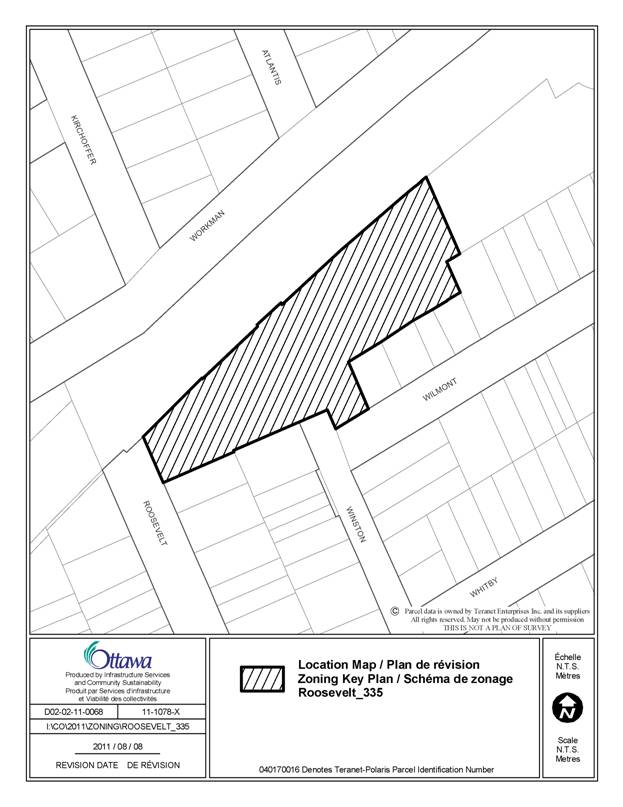
The subject property is located in the Westboro Community, at the northern end of Roosevelt and Winston Avenues. Its northern boundary is a City pathway and the Transitway. The site is relatively flat in nature, approximately 0.55 hectares in size but is irregular in shape, being approximately 150 metres long and having varying widths between 20 metres and 54 metres. To the south and west of the subject property are single detached dwellings while to the east is a seven-storey apartment building. To the north is the Transitway, including the Dominion and Westboro Stations; while further to the north is low-density housing.
The subject property is currently occupied by three one-storey buildings containing a light industrial manufacturing use (Fendor Glass and Aluminium). This use will be moving to another location. It is the applicant’s intent to demolish the existing buildings and construct on the property, two new residential condominium high-rise apartment buildings. These buildings are intended to be 14 and 16-storeys in height, contain a total of approximately 194 units and have the majority of the required parking provided underground.
The subject property is currently triple zoned. The majority of the lands are zoned Residential Fifth Density R5B[1195] H(19), with a small portion (approximately 200 square metres) zoned Residential Fifth Density R5B[816] H(21) and another small portion (approximately 307 square metres) zoned Residential Third Density R3S. The portion of the site zoned R5B[816] H(21) is located along the far eastern property line, for a length of approximately 33 metres and a depth of approximately 6.0 metres. The portion of the site zoned R3S is located at the corner of Winston and Wilmont Avenues, is vacant and is the size of a lot typically found in the low density residential area to the south. The current Residential Fifth Density zones on the property will permit the proposed high-rise apartment buildings, but not the requested heights of 47 and 53 metres for the two towers. The exceptions [816] and [1195] currently applying to the property both increase the minimum required front yard from 3.0 metres to 6.0 metres and the minimum required corner side yard setback from 3.0 metres to 4.5 metres. The [816] has an additional provision of allowing below-grade parking spaces to be 2.4 metres wide, instead of 2.6 metres.
The applicant has indicated that while they are requesting an increase in height, as well as modification of other performance standards, their proposal does not request an increase in density for the property. The proposal consists in the realignment of the allowable density in a different form. Indeed, by applying the applicable setbacks and height limit under the current zoning, there is an as-of-right development potential of approximately 20 410 square metres. As presented in this submission, the applicant`s development proposal does not exceed this permitted gross floor area. This is important to remember when considering the impact of the development proposal on the surrounding community.
Development Proposal
Each of the two buildings proposed is intended to have a floor plate of approximately 750 square metres. The separation distance between the main walls of the buildings is to be approximately 37 metres.
Vehicular access to the 16-storey (westerly) building is proposed to be from Roosevelt Avenue while access to the 14-storey building (easterly) is intended to be from Winston Avenue, by the intersection with Wilmont Avenue. Some visitor parking for the 14‑storey building will be provided at grade.
A public pathway is intended to be provided at the terminus of Winston Avenue, through the site, to provide a pedestrian connection to the City pathway running parallel to the Transitway. Currently local residents cut across the subject property to access the City path, as well as the Dominion and Westboro Transit Stations, but this is done in an informal manner. Through the development of the site, the public access will be formalized. Public access is also intended to be provided to the pedestrian plaza between the two buildings. A treed area is to be provided to the south of the surface visitor parking area. With the redistribution of the allowable development potential into the form of two smaller plate apartment buildings, approximately 71.5% of the subject property will be unbuilt at grade. As the majority of parking is being provided underground, the site will be significantly landscaped, including the construction of two reflecting ponds and a large vegetated area on the eastern portion of the site. In addition to landscaping the subject property, the applicant has indicated that through the Site Plan Control process they would also realign and improve the City pathway, have it extensively landscaped and lit.
DISCUSSION
Traffic and Density
While concerns over residential intensification are often centred on such issues as an increase in density and the resulting increase in traffic, this usually results from a proposal to increase the density of development currently allowed under the existing zoning. This rezoning proposal is different as the proposed density of approximately 20 410 square metres is representative of the density allowed by the current zoning. As a result, the proposed rezoning is not a request for an increase in development potential, rather it is to take the density already allowed and to have it permitted in another form and design.
The traffic study prepared for this proposal followed procedures approved by the City. Traffic volume data, which is compiled over years of traffic counts, was provided by the City to the applicant to help complete their study. That City data was not complete for all the surrounding intersections and was augmented by traffic counts taken on Tuesday, January 18, 2011. The City-approved traffic study indicates that for a development of 220 units and assuming a 23% modal split, during the AM peak, there will be approximately 13 vehicles entering the site and 59 vehicles exiting the site. For the PM peak, these values were 44 vehicles entering the site and 26 vehicles exiting the site. If the units are reduced to 194, as proposed, and the desired 40% modal split called for in the Secondary Plan is used, during the AM peak, there will be approximately nine vehicles entering the site and 41 vehicles exiting the site. For the PM peak, these values were 31 vehicles entering the site and 18 vehicles exiting the site. Nevertheless, at the worst, the increased volumes represent the equivalent of just over one extra vehicle per minute on the immediately surrounding streets.
While the additional vehicles do not represent a significant increase and will not necessitate any roadway modifications, it must be noted that these vehicles are not a result of the applicant`s request for an increase in height, they are directly associated with the existing development potential on the property and with that development potential, these volumes are already anticipated to be on the surrounding streets.
The above analysis would be different if the applicant were requesting additional development density, but the end result is that the number of units (people) and the increased traffic that will be generated by this proposed rezoning represent an impact that is already inherent with the subject property.
Staff are of the opinion that the proposed rezoning should be evaluated principally on is conformity with Official Plan and Secondary Plan policies in relation to the impact of height, distribution of massing, compatibility and the design of the proposed development. The argument being, from a planning perspective, is it more appropriate to develop the site with the number of units and building envelope allowed by the current zoning or to redistribute the permitted massing? The current zoning would create buildings of seven storeys, which, being almost identical to the building immediately to the east would result in a wall of development that would be akin to a large rectangle approximately 230 metres long. The alternative is to reshape the development on the subject property into taller, thinner buildings. This would increase the amount of open space on the subject site, as well as the light penetration between buildings. It would provide for more landscaping, formalize public access through the site and use building design to integrate a development into the community. It is the Department’s position that the latter is the correct approach and is in keeping with the direction of the Official Plan and the Secondary Plan for Westboro, as presented below.
Primary Official Plan
The City`s Primary Official Plan
designates the subject property as General Urban Area. The General Urban Area designation is intended to permit
the development of a full range and choice of housing types to meet the needs
of all ages, incomes and life circumstances.
A broad scale of uses is found within this designation, from
ground-oriented single-purpose to multi-storey mixed-use; from corner store to shopping
centre. All of these are permitted with
the intent of developing complete and sustainable communities.
While the Plan is supportive of the establishment of a broad mix of uses
in Ottawa's neighbourhoods, this is not meant to imply that all uses will be
permitted everywhere within areas that are designated General Urban Area. Subject to the policies for General Urban
Areas, the City supports infill development and other intensification within
the General Urban Area, in a manner that enhances and complements the desirable
characteristics and ensures the long-term vitality of the many existing
communities that make up the city.
The policies of the General Urban Area recognize the importance of
infill development relating to existing community character so that it enhances
and builds upon desirable established patterns and built form. The subject property is already zoned for an
apartment building and this zoning was applied to the property as the site is
located along the northern edge of the community, adjacent to the Transitway
and in proximity to two transit stations.
This is a characteristic common to the surrounding area as there are
other apartment buildings situated close to the Transitway, as well as abutting
low-density residential neighbourhoods. For example, to the east there is the
adjacent seven-storey apartment building, a four-story apartment at Scott
Street and Winona Avenue, and the 32-storey Metropole by the Westboro Transit
Station. To the west is a 13-storey
apartment building located on Dominion Avenue and further west, the new 15-storey
condominium building at Richmond Road and Cleary Avenue.
It is the Department’s position that the proposed 14 and 16-storey
buildings follow this existing neighbourhood characteristic.
General Urban Area policies also state that development proposals should
be considered in relation to their contribution to the maintenance and
achievement of a balance of housing types and tenures, to provide a full range
of housing for a variety of demographic profiles throughout the General Urban
Area. This proposal will help achieve
the mix of development types and tenures envisioned by the Official Plan.
In addition to the policy discussion above, the Official Plan also
directs developments to be evaluated with respect to the compatibility policies
found in Sections 2.5.1 and Section 4.11.
And since the density of the proposed development is already permitted
by the current zoning, it is the design of the building, the distribution of
density and how the vacant portions of the site will be treated, that are an
important consideration to ensuring that the development is compatible.
Section 2.5.1.
The
Official Plan acknowledges that introducing new development in existing areas
that have developed over a long period of time requires a sensitive approach to
differences between the new development and the established area. The Official Plan provides guidance on
measures that will mitigate these differences and help achieve compatibility of
form and function. Allowing for
flexibility and variation that complements the character of existing
communities is central to successful intensification.
In
general terms, compatible development means development that, although it is
not necessarily the same as or even similar to existing buildings in the
vicinity, nonetheless enhances an established community and coexists with
existing development without causing undue adverse impact on surrounding
properties. It ‘fits well’ within its
physical context and ‘works well’ among those functions that surround it. Generally speaking, the more a new development
can incorporate the common characteristics of its setting in its design, the
more compatible it will be. Nevertheless, a development can be designed to fit
and work well in a certain existing context without being “the same as” the surrounding
development.
Design Objectives and Principles
Section 2.5.1. contains six design objectives relating to how built environment should be addressed as the City matures and evolves. These Design Objectives are broadly stated, and are to be applied within all land use designations, either at the city-wide level or on a site-specific basis. Each of the design objectives that the Department believes are relevant to the applicant’s proposal are presented below, as well as how the Department believes they are being satisfied.
The first design objective is to
enhance the sense of community by creating and maintaining places with their
own distinct identity. To fulfill this
objective, design should:
- Support the overall image of Ottawa as the Nation’s capital.
- Recognize and reflect on the history of the city or community.
- Promote quality consistent with a major metropolis, and a prime business and tourist destination.
- Create distinctive places and appreciate local identity in patterns of development, landscape and culture.
- Reflect a thorough and sensitive understanding of place, context and setting.
- Consider public art early in the design process and integrate it, as appropriate, as part of the project.
The proposed development will meet these design policies by incorporating a quality of architecture that will enhance and improve upon the image of the City as well as promote Ottawa as a major metropolis. The placement of high-rise apartment buildings on the property is reflective of an existing characteristic, whereby low-rise, mid-rise and high rise apartments are located at the northern edge of the Westboro community, close to the Transitway and its stations. By increasing the setbacks for buildings from the existing low-rise residential dwellings to the south, by having over 70% of the property as open space, and by making the podium towers only 750 square metres to minimize impact on surrounding properties, the proposed development represents a thorough and sensitive understanding of place, context and setting. The proposal is also intending to have public art along the northern edge of the site, by the City walkway. This will be provided through the Site Plan Control process.
The second design objective relates to defining quality public and private spaces through development. To fulfill this objective, design should:
- Clearly define and connect public and private spaces by:
- Defining and enclosing spaces using buildings, structures and landscaping.
- Recognizing every building as being part of a greater whole that contributes to the overall coherency of the urban fabric.
- Enhance and enliven the quality, character and spatial delineation of public spaces.
- Meet the needs of pedestrians as a priority.
- Contribute to attractive public spaces and important vistas.
- Minimize the exposure of inhabitants to noise levels that could adversely impact their health and well-being.
The proposed development will use landscaping, both hard and soft and structures, such as the buildings and planters, to help define the relationship between the publicly-accessible area on the subject property, (e.g. the pedestrian easement from Winston Avenue), the City-owned public path alongside the Transitway, and the private area on the subject property that will be for the condominium residents. By using various materials to provide texture, colour and relief, and by providing amenities such as benches, public art, vegetation and reflecting pools, the quality and character of the public spaces provided will be enhanced and made more attractive. At the junction of the public pathway and the pedestrian extension of Winston Avenue, there will be a new plaza that will serve as a neighbourhood focal point for pedestrians walking to and from the neighbourhood and the two nearby rapid transit stations. Through the Site Plan Control process, a noise study will be completed to evaluate the impact of the surrounding noise factors, such as the Transitway, on the new buildings to see what mitigation measures (e.g. window treatments and air-conditioning) need to be employed for the residents of the proposed buildings.
A third design objective to consider when evaluating a rezoning proposal is the ability of the proposal to create places that are safe, accessible, easy to get to and easy to move through. In this regard, design should:
- Connect buildings and spaces through a network of roads, sidewalks, and pathways in ways that are understandable. These connections should be accessible to all users and incorporate the principles of universal access and where connections lead into a building, the building and its facilities should be designed so that it can be approached, entered, and used by persons with physical or sensory disabilities.
- Integrate public transit with existing and new development, where feasible.
- Provide appropriate (i.e., size and placement) signage identifying pathways, intersections and landmarks.
- Create places and spaces that are visible and safe and can be confidently used at all hours of the day and at night where it is appropriate to do so.
The formalized pedestrian pathway provided on site will be a minimum of six metres wide; it, and other paths and plazas on the property will be of materials that delineate them as such. They will be universally accessible, signed and lit, making them suitable for way-finding and easy and safe to use. Direct and easy access will be provided from the site to Dominion and Westboro stations, to ensure that the new development creates publicly accessible spaces that improve pedestrian access to important destinations.
The
fourth design objective provides that development should:
- Be integrated to complement and enliven the surroundings.
- Allow the built form to evolve through architectural style and innovation.
- Complement the massing patterns, rhythm, character, and context.
The landscaping, open space, resulting light penetration and air circulation associated with the redesigned massing of the development potential to point towers, instead of a walled development, will complement and enliven the surroundings. It will provide for an architectural and landscaped architectural style that shows innovation that will complement the rhythm, character and context of the surrounding area. Residential units with direct ground access along the City pathway maintain the fine-grained rhythm of traditional housing and improve safety.
The fifth consideration of design in allowing taller buildings is to provide for adaptability and diversity, by creating places that can adapt and evolve easily over time and that are characterized by variety and choice. In this regard, design should:
- Achieve a more compact urban form over time.
- Allow for varying stages of maturity in different areas of the city, and recognize that buildings and site development will exhibit different characteristics as they evolve over time.
- Accommodate the needs of a range of people of different incomes and lifestyles at various stages in the life cycle.
The proposal to construct point towers is a relevant example of compact urban form for this site, given its shape. With the landscaping, open space, building setbacks and architectural characteristics provided, the proposed development can be better integrated into the surrounding community than a larger, lower slab-type building as is currently permitted.
As well, the units provided will help fulfill the goal of providing accommodation to meet the needs of people of different incomes and lifestyles at various stages in life.
The final design objective relates to understanding and respecting natural processes and features, and to promote environmental sustainability in development. To accomplish this, design should:
- Protect, integrate and enhance the urban forest, vegetative cover, green spaces and corridors, environmental features and landscapes, and existing topography, where possible and appropriate.
While the subject property does not currently contain much vegetation, this will be significantly enhanced through this development proposal. Constructing two point towers creates a large amount of open space that can be vegetated. For example, an area on the eastern portion of the site, approximately 41 metres long and between 16.5 and 22.8 metres wide will be landscaped area. This would not be possible if construction was to occur on the property under the current zoning.
In addition to the design policies contained in Chapter Two of the Official Plan, the proposed rezoning must also be evaluated in relation to the compatibility policies in Chapter Four, namely Section 4.11. While certain policies, such as loading and the location of vehicular access are issues for Site Plan Control, and other considerations, such as traffic, are not pertinent to this proposal as the development potential is not increasing and the traffic that would be generated is already anticipated by the current zoning, there are other specific policies in this section that give direction to evaluating rezoning proposals, and in particular, they are the policies relating to height and massing, sunlight and microclimate.
The Official Plan states that new buildings should have regard for area context. As presented, it is the Department’s position that the context of the area includes apartment buildings, including high-rise apartment buildings, along the edge of lower density residential areas near the Transitway. As indicated in the section of this submission regarding Section 2.5.1. of the Official Plan, the proposed development utilizes appropriate design principles, such as building placement, direct openings to the public realm, open space, landscaping and amenities that contribute to a sense of human scale, which will improve and enhance user comfort, as well as the perception of the new development within the existing context. There is a transition in building height between the proposed apartment buildings and the adjacent apartment building to the east. The proposed buildings also use the natural buffer of the Transitway, a smaller footprint to increase open space, appropriate setbacks and design elements to create a more pedestrian-friendly at-grade environment.
While there is currently no legal “right to light”, development should minimize shadowing on adjacent properties to the extent possible, particularly on outdoor amenity areas, through the siting of buildings or other design measures. This policy recognizes that developments cause shadows, they are inevitable. It also provides direction by stating that shadow impact can be minimized through the siting of buildings and design measures. It is recognized that generally speaking, taller buildings cast longer shadows than shorter buildings, but also that thinner buildings cast narrower shadows which move more quickly throughout the day. By increasing the distance between the towers and by decreasing the floor plate of the building, the shadow impact can be minimized.
Instead of a wide wall of shadow that would remain a longer time during the day, being produced by seven-storey buildings approximately 230 metres long, two longer but slimmer shadows moving quickly from west to east as the day progresses, are more appropriate as they minimize the impact they have on individual properties they contact.
When weighing towers versus a wall of building, consideration must also be given to the impact on the penetration of sunlight and the sky. From a pedestrian perspective, a wall of building blocks out the sky. For example, if one were to stand on Winston Avenue and look north, or stand on Workman Avenue by Atlantis or Kirchoffer Avenues and look south, all one would see is building. The view would be obscured and light penetration would be minimized. Under the applicant’s proposal, however, if one was to stand at these locations and look towards the subject property, they would see the buildings proposed but they would also see sky and there would be significant light penetration.
Separating the buildings results in an increase not only of light penetration, but also the movement of air, which has a more positive effect on microclimate, including the temperature on adjacent properties.
Richmond Road/Westboro Secondary Plan
In addition to the applicable policies in the Primary Official Plan, the site is also subject to the policies of the Richmond Road/Westboro Secondary Plan. The Secondary Plan has been established to give further guidance and direction for the long-term design and development of the area. The Secondary Plan describes the Richmond Road/Westboro area as a location that will continue to be an attractive place to live, with an enhanced greenspace network, a wide mix of uses, including employment, neighbourhood services and facilities, a range of housing type choices, excellent transit service and well-designed compact and inclusive development that will enhance the area’s diversity and vibrancy. It is the Department’s position that the proposed residential development of two high-rise towers, with over 70% open space, public pathways, extensive vegetation and ease of access to the Transitway, will provide for a development that will enhance the neighbourhood’s overall desirability.
The Secondary Plan indicates that the subject property is located in Sector Seven - Scott Street and the Westboro Transitway Station Area. While the second policy bullet for Sector Seven provides that infill developments on the subject property shall be generally four to six-storeys in height, the fifth principle of Objective One (Intensification) Section 1.2, also incorporates flexibility into maximum building heights.
It indicates that taller buildings will be limited to sites where they are compatible with adjacent uses, such as the Ottawa River Parkway open space, have deeper lots, or have other natural or manmade separations enabling impact associated with such development to be mitigated, and where lesser heights abutting existing lower buildings can be provided. Section 1.2 of the Secondary Plan also calls for new development to provide an appropriate transition and setback to the adjacent low-rise residential community, as well as to respect existing built form and neighbourhood character. It is further desirable for new development to have a shared use of facilities and energy efficient buildings.
As noted, compatible development does not have to be the same as existing development. The proposal uses its location at the edge of the community, proximity to the Transitway, the distance of the proposed buildings to adjacent properties, slender towers, extensive hard and soft landscaping, open space, public access and building materials to address compatibility and provide a separation/transition to the surrounding development, to mitigate against adverse impact. By utilizing these characteristics, the policies of the Secondary Plan, which are intended to allow compatible development, are satisfied.
Official Plan Amendment 76
On June 24, 2009, City Council approved modifications (Official Plan Amendment 76) to the City’s Ontario Municipal Board (OMB) approved Official Plan, as part of the required five-year review. Appeals were launched against this Official Plan Amendment and the applicant filed their application before the recent OMB decision that largely addressed the outstanding appeals. While the applicant is therefore “grandfathered” from having the changes of Official Plan Amendment 76 considered as Official Plan policy, it is important to note that nonetheless, their proposal satisfies the relevant policies contained in this Amendment.
A major consideration of Official Plan Amendment 76 is the policies relating to Building Profile and Compatibility. The Official Plan Amendment indicates that integrating taller buildings into an area characterized by a lower built form is an important design consideration, particularly in association with intensification. New development will address issues of compatibility and integration with surrounding land uses by ensuring that an effective transition in built form is provided between areas of different development profile. This transition will serve to link the proposed development with the existing development, as well as the planned function of the zoning. Transition can be achieved through a number of means, such as, incremental change in building height, massing, architectural design, character (i.e. scale and rhythm, building materials) and building setbacks.
It is the Department’s position that the setbacks proposed from the adjacent low-density residential buildings to the south, which range from 7.5 metres to 16.4 metres, will help create the transition anticipated by the policies. This transition will also be enhanced as this area is largely landscaped. As well, transition will also be enhanced through the architectural design and building material of the development, which create an aesthetically pleasing structure and a built form of the ground floor that is of a lower density townhouse development. The site being located at the northern termination of two city blocks, it has the ability to accommodate taller buildings without shadowing the closest residences, which are to the south, and to take advantage of the extra separation provided by the Transitway corridor so that the nearest homes to the north are more than 45 metres away from the site’s northern property line.
The new policies of Official Plan Amendment 76 also state that by virtue of their size and prominence, high-rise buildings perhaps have a greater potential to impact the qualities people value about a place, more so than lower height buildings. As such, Official Plan Amendment 76 contains specific policies to evaluate proposals for high-rise buildings. As presented below, it is the Department’s position that the applicant’s proposal satisfies these policies.
This submission provides examples of how the scale, massing and height of the proposed buildings are a contextual fit with the character of the area, as other high-rise apartment buildings are located near the Transitway and how the proposed development conforms to Official Plan and Secondary Plan policies.
The proposal uses setbacks, design and building materials to create an appropriate transition, and the size of the property provides for an opportunity for larger buildings. The proposed development will enhance and create new views and vistas, and will be a visual landmark for people walking to and from both the Dominion and Westboro rapid transit stations. The architectural design employed is of a high quality and will have a positive effect on the skyline. The new development will provide approximately 70% landscaped open space, much of it vegetated, with a formalized pedestrian access running north to south through the property. This will greatly improve the public realm, as will removing the current industrial use and its related truck traffic from a residential neighbourhood. The City Pathway to the north and opposite the applicant’s property will be redesigned, reconstructed and relandscaped. The applicant’s land will include public art and reflection pools as public amenities and a pedestrian plaza as a respite area. Public transit will be easily accessible while the surrounding streets do not need any improvement to service the anticipated traffic volume from the development. By using towers with a small floor plate (750 square metres), sun shadow impact on properties to the north and the negative impact on private amenity areas will be minimized. The proposed development will open up views to the sky better than what can be developed under the current zoning. The proposed development will have the majority of its parking underground, along with garbage storage and collection. Through the Site Plan Control Process, the location and impact of service functions on the surrounding properties will be minimized.
Transit Oriented Development Guidelines
The growth strategies in the Official Plan direct higher density to specific areas within the city, such as Traditional Mainstreets, Mixed-Use Centres and the Downtown Core. However, it is also recognized that greater intensities of development should occur in proximity to rapid transit stations, to provide more people the opportunity for easier access to transit services. Indeed this has long been a sound planning principle and is a reason why the site currently has a development potential that would allow approximately 20 410 square metres of gross floor area.
However, having a higher development potential is only part of the equation to help satisfy the City’s larger long-term goals of increased transit ridership. Another part of the equation and what is for consideration in the applicant’s proposal, is creating a site layout and designing a ground level that encourages pedestrian movement and supports easy access to rapid transit.
By providing a pathway from the community to the south, across the site to the City path, by landscaping and making both the pathway on the subject lands and the adjacent City path easy to use day and night, there will be better conditions for people to use public transit. Constructing under the current zoning could restrict this ease in movement, result in a development that is less appealing from a convenience and safety perspective, and not contribute as well to achieving the City’s goals of increased transit ridership. In an effort to increase transit ridership from the development of the proposed buildings, through the Site Plan Control process, the property owner will be providing free to the owner of each unit, one express bus pass for a period of one year.
High-Rise Development Guidelines
In keeping with the policy direction to have higher density development near transit stations, the anticipated higher density is often associated with high-rise buildings. To help ensure that high‑rise buildings are integrated into the surrounding urban fabric in a compatible manner, the City has prepared a set of guidelines for this type of housing. There are 68 separate guidelines separated into different categories, such as context, built form, pedestrians and the public realm, open space and amenities, environmental considerations, site circulation and parking, as well as services and utilities. While some of these are more appropriate for consideration through the Site Plan Control process, all of these are presented so as to allow high-rise buildings to be successfully integrated into the surrounding community. With regard to the applicant’s rezoning, the high-rise buildings will contain compact floor plates, which, with their proposed separation of approximately 40 metres, will maximize views, light penetration, solar exposure and air circulation and ventilation. The smaller floor plate and resulting towers minimize shadowing on adjacent properties. At the ground level there is ample space for safe and accessible pedestrian activity, such as walkways and courtyards. The majority of parking is provided below grade to maximize landscaping and open space. Architectural variety on the ground floor and proposed increased setbacks above the second-storey will help maintain a human scale. If approved, the rezoning will allow for a development that follows the Guidelines established by the City for High-Rise developments.
Details of Proposed Zoning
Given the irregular shape of the lot and to address technical issues like a low planter or parking ramp wall technically being the setback of a building, even though the main wall of the building may be located many metres away, the applicant has provided a list of amendments required to performance standards required for the proposal. However, the argument has been put forward in this submission that the amount of allowable gross floor area is not being increased and the two slender point towers proposed are an appropriate form of development for the site.
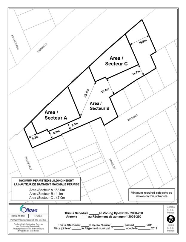
While the Department believes that the applicant will construct the two towers as proposed, an extra level of assurance can be provided to the community by capping the development potential to that which is currently allowed and by using a schedule to denote where the building mass will be located and what portion of the property will be vacant. While the architectural design of the building will be very intricate, for legibility and to minimize anomalies, the developable areas approximate the shape of the buildings. The corresponding schedule of height and yards can be seen in Document 2.
Two extra provisions, one allowing accessory structures, such as a gazebo in Area B, and the other allowing permitted projections, such as a canopy or a vertical privacy trellis, have been added to the details.
COMMENTS BY THE WARD COUNCILLOR
Councillor Katharine Hobbs is aware of the application.
LEGAL IMPLICATIONS
Should this matter be appealed to the Ontario Municipal Board, it is anticipated that a two day hearing would result. In the event that the recommendation above is adopted, the matter could be handled within staff resources. Should the recommendation be refused, reasons must be provided. In the event of an appeal of the refusal, it would be necessary to retain an outside planner at an estimated cost of $20,000 to $25,000.
FINANCIAL IMPLICATIONS
ACCESSIBILITY IMPACT
Approval of the rezoning will allow continued at-grade access between the residential community to the north, the City-owned pathway along the Transitway, and the residential community to the south.
ENVIRONMENTAL IMPLICATIONS
A Phase I and Phase II Environmental
Site Assessment has been completed for this rezoning application. As the site is moving to a more sensitive
residential use from an industrial use, as part of the Site Plan Control
Process, site remediation and a Record of Site Condition will be required.
TECHNOLOGY IMPLICATIONS
CITY STRATEGIC PLAN
Manage growth and create sustainable communities by ensuring that new
growth is integrated seamlessly with established communities.
APPLICATION PROCESS TIMELINE STATUS
The application was not processed by the "On Time Decision Date" established for the processing of Zoning By-law amendments due to the need to have additional meetings in the community to discuss the proposal.
SUPPORTING DOCUMENTATION
Document 1 Location Map
Document 2 Schedule of Height and Yards
Document 3 Details of Proposed Zoning
Document 4 Consultation Details
DISPOSITION
City Clerk and Solicitor Department, Legislative Services to notify the owner, applicant, OttawaScene Canada Signs, 1565 Chatelain Avenue, Ottawa, ON K1Z 8B5, Ghislain Lamarche, Program Manager, Assessment, Financial Services Branch (Mail Code: 26-76) of City Council’s decision.
Planning and Growth Management to prepare the implementing by-law, forward to Legal Services and undertake the statutory notification.
Legal Services to forward the implementing by-law to City Council.
LOCATION MAP DOCUMENT
1
Height and Yards Schedule DOCUMENT 2
DETAILS
OF RECOMMENDED ZONING DOCUMENT
3
Rezone the lands shown in Document 1 from R5B[1195] H(19), R5B[816]
H(21) and R3S to R5B[XXXX]SYYY.
- Add a new exception,
R5B[XXXX]SYY, to Section 239 – Urban Exceptions with provisions in Column V
similar in effect to the following:
(i) Table
164A, Row B, Columns VII through XI inclusive detailing the height and setback
requirements do not apply and maximum permitted heights and required setbacks
are as set out on Schedule YYY
(ii) Schedule
YYY does not apply to accessory buildings or structures which continue to be
regulated by Section 55
(iii) Despite
the maximum permitted height limit in Schedule YYY, permitted projections and
vertical privacy screens may project into required yards and up to any lot line
(iv) Total
maximum allowable gross floor area for all buildings, excluding accessory
buildings: 20 410 square metres
- Add Document 2 to Part 17 – Schedules as a new Schedule
CONSULTATION DETAILS DOCUMENT
4
NOTIFICATION AND CONSULTATION PROCESS
Notification and public consultation was undertaken in accordance with the Public Notification and Public Consultation Policy approved by City Council for Zoning By-law amendments. One hundred and eight-five people provided comments. One hundred and twenty-one people expressed individual concerns while an additional 53 people expressed concerns through a form e-mail response. Six people were in favour of the proposal while five wanted more information. A petition containing 145 names in opposition to the proposal was also received. The preamble to the petition is provided below. One comment in opposition was also received from the Westboro Beach Community Association. Before the application was submitted, two preconsultation meetings were held in the community and one public meeting was held by the Ward Councillor on September 27, 2011, at the Churchill Senior’s Centre. Approximately 150 people attended the September 27th meeting. The comments from the Westboro Beach Community Association, a summary of the concerns expressed and reasons in support, as well as a response to the concerns, are provided below.
SUMMARY OF PUBLIC INPUT
Concerns Expressed Over Proposal
1. This proposal will only lead to more traffic congestion on the surrounding streets and intersections.
Response
It is understood that with a new building there will be more traffic on the surrounding street, but that traffic is associated with the site’s current development potential under the present zoning. The applicant’s rezoning request does not increase the traffic beyond what would currently be associated with the development of the site. It should also be noted that with the redevelopment of the property there will no longer be industrial traffic using the surrounding local roads to travel to and from the subject property.
2. The traffic study completed for this proposal is flawed and not representative of the true impact.
Response
The traffic study provided follows all City procedures and policies. The City provides traffic volumes to the consultant for the surrounding streets. The applicant undertakes their own counts and compares them to the values from the City. If there is a significant difference, an additional count could be taken or a correction formula, determined over years of taking counts, could be applied to the numbers to see if they more accurately reflect City counts. If the City counts continue to show significantly more traffic, then those counts are used.
3. There will be a loss of privacy as people with balconies will be looking into my back yard.
Response
While this could be a problem with a seven-storey building, the smaller floor plate of the buildings and proposed increased setbacks are intended to help maintain the privacy of surrounding homes.
4. There will be a loss of green space.
Response
As the subject property is currently being used for light industrial uses there is not much existing green space. The proposed development will increase the amount of green space on site. As mentioned, along the eastern side of the property there will be a landscaped area approximately 41 metres long and between 16.5 and 22.8 metres wide
5. There will be more pollution and emissions.
Response
The applicant is not proposing to increase the density of development that is currently allowed by the existing zoning. Therefore the pollution and emissions associated with the proposed development are in keeping with what could be expected to come from the site. Pollution and emissions from the current industrial use will cease.
6. The heights of the towers do not fit in with the character of the surrounding area and will contribute to a loss of community character.
Response
The Department
has presented in this submission that apartment buildings, including high-rise
apartment buildings, are a characteristic of the community. As well, through design, increased setback,
separation of towers and landscaping, the proposed development will contribute
in a positive way to the character of the community.
7. The new buildings are just too high.
Response
It is the Department’s position that the reshaping of the development potential already allowed on the property will result in buildings that are appropriate for the property, with a height that is appropriate and similar to other tall buildings that make up the greater community.
8. The proposed development is not at a human scale.
Response
Tall
buildings can have a human scale. Human
scale is determined by what takes place at the ground level. Design elements such as building openings,
materials, architectural design, separation of buildings, landscaping and open
space, all contributes to human scale.
It is the Department’s position that the human scale that will result
from this development is greater than what could be provided under the current
zoning.
9. The proposed development will only worsen the already bad on street parking situation.
Response
All
parking required by the Zoning By-law, including visitor parking, is being
provided on the subject site. Nevertheless,
as the applicant is not increasing the development density of the proposal, any
temporary parking that would occur on the surrounding streets is already
associated with the current zoning of the property and would occur if the
property were to develop with that zoning.
10. Increased traffic will create an increased risk to pedestrians, especially children.
Response
As
with the parking, the traffic generated by this proposal is the same that would
be generated if the applicant were to develop under the current zoning. The proposed development does not result in
an increase in traffic beyond that which would already occur from the property. As well, drivers travelling to and from the
property are expected to obey traffic rules and have regard for
pedestrians. It should be noted that
with the redevelopment of the site, there will no longer be industrial traffic
travelling on the surrounding local streets.
11. The existing zoning and in particular, its height, should be respected.
Response
Under
the Planning Act, people have a right
to file a rezoning and such an application is evaluated in relation to policies
and guidelines prepared by the City. If
a proposal is deemed to conform to those policies and follow the guidelines,
then City Council can approve the rezoning of the property.
12. The proposed development will create shadows and result in a loss of sunlight on my property.
Response
It is
recognized that the buildings will cause shadows, all buildings do, but by
increasing the separation distance between towers and shrinking their floor
plate, the impact of the shadowing can be minimized.
13. The proposed development will block out the sky.
Response
By
having two separate towers, there will be light penetration between the
buildings. If the property were to
develop under the current zoning, there could be a wall of development that
would inhibit light penetration and block out the sky.
14. The proposed development will restrict or eliminate access to the walkway by the Transitway, as well as Dominion and Westboro station.
Response
Currently there is an informal access through the property to the City-owned
walkway parallel to the Transitway. The
proposed development will formalize this access whereby through the Site Plan
Control process, the pathway will be paved, landscaped and the public right to
access will be registered on title. If
the property were to develop under the current zoning, this access could be
lost as a building would be located across the entire property.
15. The proposed development will destroy the walkway by the Transitway.
Response
The
walkway is on City property and will not be removed. Through the Site Plan Control process the
City pathway will be improved. The
applicant is intending to relocate this pathway away from the fence along the Transitway
and add significantly more landscaping.
The aesthetics of the pathway will be greatly enhanced.
16.
The
proposed development does not conform to the Richmond Road/Westboro Community Design
Plan.
Response
As
presented in this submission, the proposed development satisfies the policies
of the Richmond Road/Westboro Secondary Plan, and the Community Design Plan.
17. We already have enough condos in the neighbourhood.
Response
The
Department does not have the legal authority to restrict condominium
development. Buildings are approved if
they satisfy City policy. The number of condominiums constructed and the tenure
(rental or ownership) of a development originate from demographic and market
demands and is not something that the City can regulate.
18. The construction will be disruptive to the streets and cause too much noise.
Response
It is
recognized that during the construction phase, there will be construction
disruptions to the surrounding streets; however this will only be temporary
until the building is completed.
19. The proposal cannot be accommodated by the existing sewer and water infrastructure.
Response
The
impact of the proposed development on City services is an issue that will be
addressed at the time of Site Plan Control Approval.
20. The proposal will lower my property values.
Response
There
is no evidence that the proposed development will lower anyone’s property
values. In fact, residential
intensification that has occurred in the Westboro area is generally credited
for upgrading property values.
Preamble to the Petition
We wish to register our opposition to the proposed amendments by
Uniform Urban Developments to the Zoning Bylaw covering the Fendor site at 335
Roosevelt Avenue. The Fendor site is in the middle of a low density area
comprising predominantly two-storey housing. Uniform’s proposal of 194 units in
two towers reaching 14 and 16 storeys is incompatible with the existing
character and is contrary to the city’s current zoning restrictions. The City
of Ottawa’s Community Development Plan and Secondary Plan, with careful
consideration from all involved parties, decided that the most appropriate
zoning for the Fendor site was for buildings with a height limit of 19 meters
(mid-rise; four-six storeys). This is as appropriate now as it was
previously and we request that the proposed amendment is rejected. As voters
and taxpayers we have the right enjoy our homes and community under the
protection of established zoning bylaws.
September 27, 2011 - PUBLIC MEETING COMMENTS
The concerns expressed at the public meeting were those expressed through the public consultation process.
Reasons in Favour of the Proposal
1. I would like to state my enthusiasm for the development. I think that the options have been considered carefully and that a fair compromise has been struck.
2. I am excited to invite all these new people into the community.
3. I believe that the buildings will be an improvement to the current area.
4. All sorts of infill developments are doing wonders for Westboro, they help it become a hub of activity.
5. Please count my support against what I am sure is a tide of people screaming not in my back yard.
6. I am in total agreement with having more building height, which leads to more greenspace.
7. More greenspace will give residents in the surrounding area a tranquil place to spend time.
8. With my house being so close to the property, I prefer this option with two slender towers over looking at a solid brick wall.
9. Development is going to happen either way and this option is more pleasing to the eye.
10. I was at the meeting last night and I support the proposed height of 53 metres.
11. The architect is reputable and more buildings like this will serve to elevate the level of architectural class and competition here in Ottawa.
12. I love the neighbourhood and without buildings like these I will be forced to move to the suburbs.
13. I think the proposed development will boost economic activity and help local businesses.
COMMUNITY ORGANIZATION COMMENTS
The Westboro Beach Community Association provided a number of comments to the City, however, the ones below are titled as their response to the rezoning.
Westboro Beach Community Association
Position on the Uniform Developments Zoning Application (Former Fendor Property)
Issue
Uniform Urban Developments wants to build two high-rise towers (one 16 and one 14-storey building) on the former Fendor site (335 Roosevelt Avenue). This is almost three times the height that is permitted under the current zoning.
Community Position
The communities on both sides of the transitway do not want these high-rise towers.
We want the existing zoning to be respected. We also want meaningful community consultation about how the former Fendor property should be developed, within the existing zoning and respecting City and Provincial planning guidelines.
Rationale
To date, consultations with the developer have not been meaningful. This is because the developer has not submitted any reasonable, thoughtful designs that fit within current zoning laws and planning guidelines. Instead, he has compared his preferred design to a purely hypothetical, massive and unattractive building.
This comparison seems to serve a two-fold purpose, namely to establish the maximum square footage that could possibly be built on the property under current zoning rules, and to predispose the community to accepting his more appealing design.
The choice between the hypothetical building and the proposed towers is a false one. It avoids the real question, which is, what is an appropriate design for the building that would fit within the current rules and complement the existing neighbourhood?
Why does the developer wish to build higher than is currently allowed on the property? We think it is because condominiums with River views sell for much, much more than ones without. That is what is really at issue here.
The developer is a very reputable builder. We have every confidence that he can erect an attractive condominium that is consistent with all applicable urban planning guidelines, within the current zoning bylaws and that is supported by the community.
When local residents moved in and poured their life savings into their homes, they did not expect that they would someday face the prospect of being surrounded by high-rises.
The proposed imposing structures
will change the character of the neighbourhood and will reduce the use and
enjoyment of our properties, and therefore the value of our properties by:
- Dominating the skyline and visual landscape for several kilometres in every direction and dwarfing surrounding homes on both sides of the transitway.
- Replacing our current view of the sky with two imposing towers and darkening our homes in winter when we most need sunlight for health and happiness. Homes on Workman Avenue currently enjoy bright winter sun through their front windows from 10 am onward even on the shortest day of the year. These buildings will put us in darkness all day, except for very brief interludes when the sun passes between the buildings, and late in the day, when there is virtually no sunshine left.
- Significantly reducing our access to solar energy by creating large and persistent shadows. On Workman Avenue and nearby properties, this will increase winter heating costs (by approximately 15%) and virtually eliminate those homes’ solar energy potential in the winter (for example, from roof-mounted panels that generate electricity or hot water). These impacts represent real and significant economic costs to these homes, and are contrary to provincial and federal programs to promote rooftop solar energy.
- Providing a perfect vantage point for anyone who might want to invade our privacy; and
- Contributing to increasing traffic in the neighbourhood.
Conclusion
The zoning of properties is a public policy decision. It needs to balance the profit motive with the needs of the community and the overall public interest.
We call on the Planning Committee to deny the Developer’s application to change the zoning for the property at 335 Roosevelt Avenue.
We call on the Developer, Uniform Urban Developments, to withdraw their application for a zoning change and to propose, in a spirit of true consultation with the community, a design that fits within the existing zoning, style and character of the neighbourhood, meets all applicable City and Provincial guidelines, and is acceptable to the community.
We invite the developer to meet with the community to discuss thoughtful alternative designs that fit within the community, will minimize the negative effects described above, and that respect the current zoning and all applicable City and provincial guidelines.
Response to Comments From the Westboro Beach Community Association
As presented in this submission, it is the Department’s position that the rezoning and resulting proposed development is in keeping with the policies of the Official Plan, the Richmond Road/Westboro Secondary Plan, the Transit Oriented Development Guidelines and the High‑Rise Development Guidelines. It is compatible with the character of the neighbourhood and represents an excellent example of how taller buildings can use design, slender profiles, landscaping, open space, building materials, setbacks and separation distances to be positively integrated into the community. It represents a considerable improvement over what could be built under the current zoning.