|
8. ZONING – 450, 500 AND 550 TERMINAL AVENUE, 55, 100,
150 AND 165 TRAINYARDS DRIVE, 515, 641, 651 AND 663 INDUSTRIAL AVENUE AND 820
AND 848 BELFAST ROAD ZONAGE – 450, 500 ET 550, AVENUE TERMINAL, 55, 100,
150 ET 165, PROMENADE TRAINYARDS, 515, 641, 651 ET 663, AVENUE INDUSTRIAL, ET
820 ET 848, CHEMIN BELFAST |
Committee
recommendation
(This matter is
Subject to Bill 51)
That Council
approve an amendment to the Zoning By-law 2008-250 to change the zoning of 450,
500 and 550 Terminal Avenue, 55, 100, 150 and 165 Trainyards Drive, 515, 641,
651 and 663 Industrial Avenue and 820 and 848 Belfast Road from General
Industrial Subzone 3, (IG3) and General Industrial Subzone 3 Exception 393,
IG3[393], and Park and Open Space Zone
O1[378] to Mixed Use Centre Exception
1387 Holding Zone, (MC7[1387]-h) as detailed in Document 2 and as shown in Document 1.
Recommandation DU Comité
(Cette question est assujettie au Règlement 51)
Que le Conseil approuve
une modification au Règlement de zonage 2008-250, de manière à faire passer le zonage des 450, 500 et 550, avenue
Terminal, des 55, 100, 150 et 165, promenade Trainyards, des 515, 641, 651 et
663, avenue Industrial, et des 820 et 848, chemin Belfast de Zone industrielle
générale, sous-zone 3, (IG3) et Zone industrielle générale, sous-zone 3, exception
393, IG3[393], et Zone de parc et d’espace ouvert O1[378] à Zone de centre
polyvalent, exception 1387 et zone d’aménagement différé (MC7[1387]-h), tel
qu’exposé en détail dans le document 2 et illustré dans le document 1.
Documentation
1.
Deputy
City Manager's report, Infrastructure
Services and Community Sustainability, dated 16 November 2011 (ACS2011-ICS-PGM-0230).
Report to/Rapport au :
Comité de l'urbanisme
and Council / et au Conseil
16 November 2011 / le 06 novembre
2011
Submitted by/Soumis par :
Nancy Schepers, Deputy City Manager/
Directrice municipale adjointe, Infrastructure Services
and Community Sustainability/Services d’infrastructure et Viabilité des collectivités
Contact Person/Personne-ressource : Richard Kilstrom,
Acting Manager/Gestionnaire intérimaire, Development Review-Urban Services,
Inner Core/Examen des projets d'aménagement-Services urbains, Unité du Centre
intérieur
Planning and Growth Management/Urbanisme et Gestion de
la croissance
(613) 580-2424, 22379 Richard.Kilstrom@ottawa.ca
REPORT RECOMMENDATION
That the recommend Council approve an amendment to the
Zoning By-law 2008-250 to change the zoning of 450, 500 and 550 Terminal
Avenue, 55, 100, 150 and 165 Trainyards Drive, 515, 641, 651 and 663 Industrial
Avenue and 820 and 848 Belfast Road from General Industrial Subzone 3, (IG3)
and General Industrial Subzone 3 Exception 393, IG3[393], and Park and Open Space Zone O1[378] to Mixed Use Centre Exception 1387 Holding Zone,
(MC7[1387]-h) as detailed in Document 2
and as shown in Document 1.
RECOMMANDATION
DU RAPPORT
Que le Comité de recommande au
Conseil d’approuver une modification au Règlement de zonage 2008-250, de manière à faire passer
le zonage des 450, 500 et 550, avenue Terminal, des 55, 100, 150 et 165,
promenade Trainyards, des 515, 641, 651 et 663, avenue Industrial, et des 820 et
848, chemin Belfast de Zone industrielle générale, sous-zone 3, (IG3) et Zone
industrielle générale, sous-zone 3, exception 393, IG3[393], et Zone de par cet
d’espace ouvert O1[378] à Zone de centre polyvalent, exception 1387 et zone
d’aménagement différé (MC7[1387]-h), tel qu’exposé en détail dans le document 2 et illustré dans le document
1.
BACKGROUND
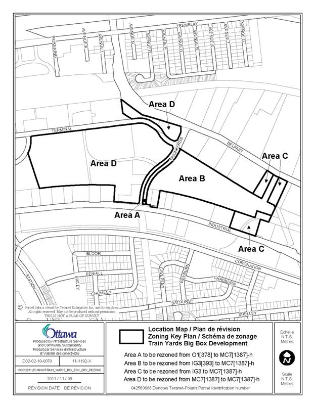
The Train Yards development is a retail, commercial and office development that is located between the VIA train station to the north, Industrial Avenue to the south, Sanford Fleming Avenue to the west and industrial uses to the east. The total area of the Train Yards is approximately 53.5 hectares in area. Approximately 10.2 hectares of this property is zoned for approximately 93 000 square metres of office space with the remaining 43.2 hectares being zoned for and occupied by a large format retail commercial centre. It is the area used for large format retail purposes that is the subject of this application. The subject lands have frontages on the south side of Terminal Avenue, both sides of Train Yards Drive, the north side of Industrial Avenue and the south side of Belfast Road as well. The lands that are subject to this rezoning proposal can be seen in Document 1.
In 2001 and 2005, City Council approved Official Plan amendments and rezoning applications to allow development of the property for retail commercial uses. The applications approved in 2001 related to the lands generally on the western side of Trainyards Drive, while the approvals in 2005 related to the lands on the eastern side of Trainyards Drive. In each of the rezoning applications, an exception was placed in the zoning limiting the amount of gross leasable area that could be used for retail purposes. Other uses allowed by the zoning, such as light industrial uses, do not have a limit to the area they can occupy. For the lands on the western side of Trainyards Drive, retail uses were limited to 35 000 square metres of gross leasable area while on the eastern side of Trainyards Drive, retail uses were limited to 12 100 square metres of gross leasable area. In both circumstances the required parking was set at a rate of 5.0 parking spaces per 100 square metres of gross leasable area. Surface parking was allowed at this rate, plus an extra 15%. Parking occurring above the extra 15% had to be provided underground or in an above-ground parking structure. In 2008, the zoning of the lands on the west side of Trainyards Drive was amended to reduce the parking requirement for commercial uses over 16 000 square metres in size, to 4.61 parking spaces per 100 square metres of gross leasable area and the amount of gross leasable area permitted was increased to 40 000 square metres.
With respect to the allowable Gross Floor Area, these were set at their respective amounts because it was the amount requested by the owner and the amount addressed in the applicable studies completed at that time. As well, since the lands were historically zoned for industrial uses and there was a desire to preserve the amount of industrial property by limiting the retail and still allowing industrial uses, it was thought that the success of the retail would help bring light industrial uses to the property. The parking rate and the requirement for underground or structured parking were established to limit the overall amount of surface parking and to provide more opportunity for landscaping.
Through this rezoning, the
applicant is requesting three things.
Firstly, that the parking required for retail uses at the Train Yards
Retail Centre be reduced from their current requirements of 5.0 parking spaces
per 100 square metres of gross leasable area to 3.4 parking spaces per 100
square metres of gross leasable area.
Secondly, that the limit to the gross leasable area of retail uses be removed,
and thirdly, that some additional lands also be included in the Train Yards
Retail Centre. These requests are being
made because other Large Format Retail Centres in Ottawa have far greater
development potential, light industrial uses have not located on the property, the
parking rate of 3.4 parking spaces per 100 square metres of gross leasable area
is a standard rate of minimum parking cited in the Zoning By-law for commercial
shopping Centres, in this area of the city, the extra land will improve the visibility
and functioning of the Centre and the rezoning will better meet the policies in
the Official Plan related to Mixed-Use Centres. While the applicant’s rezoning application did
not include the area occupied by the Wal-Mart, as the applicant does not own
it, it is an integral component of the Train Yards development. As a result, the recommendations contained in
this submission also apply to those lands.
DISCUSSION
Parking Reduction
For their proposal, the applicant
has completed a parking study. Parking
counts were taken on a typical Saturday between 11 a.m. and 2 p.m., to determine the
number and location of occupied parking spaces. Knowing the maximum number of occupied parking
spaces and the gross floor area of existing buildings, the analysis was able to
determine the utilization of the parking lot. The study determined that for the lands west
of the Trainyards Drive, at the peak time, the parking space occupancy rate was
2.41 parking spaces per 100 square metres of gross floor area. For the lands east of Trainyards Drive, the
peak occupancy rate was 2.33 parking spaces per 100 square metres of gross floor
area. Both are well below the current
zoning rate of 5.0 parking spaces per 100 square metres of gross leasable area.
It is recognized that reducing the parking requirement will help provide
an opportunity for greater development potential and this will also help
fulfill the policies related to Mixed-Use Centres. Mixed-Use Centres are identified as areas
that are focal points of activity. They
are limited in number and provide opportunities for substantial growth and
intensification. They are centred on the
rapid-transit network and provide the opportunity for people working, living or
shopping in the Mixed-Use Centre to use public transit.
The Mixed-Use Centre policies indicate that parking limits should be put
into the complementary zoning and that these will vary in response to the
contextual influence of the geographical location of individual Mixed-Use
Centres and the stage of Rapid Transit development. With this property being located on the
City’s first light rail transit line, and the future bus rapid transit line
along Terminal Avenue, it is the
Department’s position that it is appropriate to lower the parking rate from the
current 5.0 parking spaces per 100 square metres of gross leasable area. The
Department notes that the Zoning By-law has provisions for shopping centre
parking, depending on geographical location in the city generally and in
relation to rapid transit stations specifically. These are set at a minimum and a maximum
parking rate. Given that the parking
study undertaken for the application has determined that the parking needed is
less than the parking currently required and the parking requirements in the
Zoning By-law were established to represent actual parking needs, the
Department is recommending that the minimum parking requirement for the
Trainyards large format retail centre be those provided in Section 101 of the
Zoning by-law. Namely, for uses within
600 metres of a rapid transit station they shall require a minimum of 3.0 parking
spaces per 100 square metres of gross leasable space.
Beyond 600 metres the minimum parking rate shall be 3.4 parking spaces
per 100 square metres of gross leasable area.
Section 103 of the Zoning By-law contains the maximum allowable parking
requirement for a shopping centre. It is
set at 3.6 parking spaces per 100 square metres of gross leasable area for this
section of the city. Currently at the
Train Yards Centre there is no cap on the overall parking that can be provided,
only the amount of surface parking allowed. This maximum parking rate was agreed to
between the City and the applicant to help facilitate the construction of the
Wal‑Mart, so that they could provide the parking they felt was
needed. The Department is recommending
that the cap contained in Section 103 not apply to the subject lands to respect
the agreement reached at that time. Nevertheless,
the cap is in the Zoning By-law to prohibit the parking from being provided in
the first place. Current parking rates
at the Train Yards range from 4.45 to 4.99 parking spaces per 100 square metres
of gross leasable area and in this instance, these parking spaces already
exist. Approving the cap found in
Section 103 would not require the parking to be removed but would only result
in creating a legal non-conforming situation.
Finally, with approval of the applicant’s request of a greater
development potential on site, it is likely that the existing extra parking and
asphalt will be replaced by buildings, thereby moving closer to the overall
maximum parking rate.
Current Limits to Retail Commercial Uses
As presented above, with the reduction in the amount of parking required, land will become available for the construction of new buildings and uses. However, the current caps of 40 000 square metres and 12 100 square metres of gross leasable area limit the ability to develop. In fact, buildings constructed and site plans approved for development have almost exhausted the allowable development potential.
The Department can support the requested increase in development potential because of the nature of Mixed-Use Centres. As presented in the Official Plan, Mixed-Use Centres are areas of intense development potential and centred as areas of intensification, to provide employment, residential settings and to meet the needs of the surrounding community and the City at large. They are focal points of activity. Mixed-Use Centres are characterized by a broad variety of uses, such as retail uses, entertainment uses, and services, such as restaurants. Removing the cap on commercial retail uses will further support these policies in the Official Plan by allowing more intense development. As well, by having buildings occupy land that would otherwise be occupied by parking, buildings will be closer together, increasing the walkability of the Mixed‑Use Centre, which is a development policy for Mixed-Use Centres and a fundamental basis of the Train Yards Centre, whereby it was originally anticipated that one could travel easily from one store to the other, without the need to drive. Finally, removing the cap is not unique as there are other Mixed-Use Centres, such as by Scotiabank Place and portions of the Centrum Large Format Retail Centre, which do not have caps on commercial development.
While it is noted that removing the development caps currently on the Train Yards Centre is in keeping with the development policies in the Official Plan, it is also noted that the property owner has not presented any specific development proposals to the City.
And as such, it is not possible at this time to understand what the potential on existing City services will be from future development. Even when the applicant approached the City over a decade ago to commence work on the Train Yards, they had a concept of 35 000 square metres of retail and restaurant uses and 93 000 square metres of offices. Studies were also completed to evaluate the overall impact of that proposal, in relation to City services. While the applicant has provided a letter on the adequacy of sewer and water services, it is a snapshot of the current situation and does not directly represent the impact on the system of a specific development proposal. In the absence of a new overall retail development concept, the Department is recommending that a holding zone be placed on the property for retail and restaurant developments over 900 square metres in size, to be lifted pending the completion of required studies to determine environmental remediation required, if there is adequate sewer, water and road capacity to accommodate the development and if not, what measures have to be completed to provide for this capacity.
The 900 square metre exemption is based on the approximate size of smaller pad-style buildings being constructed or approved for construction on the property. This exemption will allow some future construction to continue at the Train Yards Centre, of a size that is more easily evaluated with respect to its impact on City services, until a more formal development plan is devised for larger size commercial retail and restaurant buildings and the required studies are prepared and evaluated.
Lands to be added to the Train
Yards Large Format Retail Centre
The property Owner has purchased properties along Industrial Avenue and Belfast Road and is in the process of acquiring small parcels of land at the extreme eastern edge of the subject site through a land exchange with the City. The land exchange will make the eastern boundary of the applicant’s land more regular and will help facilitate the proper functioning of the City’s adjacent bus maintenance yard, by providing access to Belfast Road.
The land to be included on Industrial Avenue has approximately 122 metres of street frontage and an area of approximately 9 340 square metres. The land included on Belfast Road is located on both sides of a vehicular access to the Train Yards from that road. The land west of that access has a frontage of approximately 34 metres and an area of approximately 4 715 square metres. The land west of the access road has a Belfast Road frontage of approximately 42.5 metres and an area of approximately 5 150 square metres. The property acquired through a land exchange with the City is irregular in shape and approximately 3 500 square metres.
As mentioned above, Mixed-Use Centres are characterized as areas of intense development. They are to ultimately develop as good places in their own right as components of complete neighbourhoods. They should contain development that is both locally and regionally oriented. It is the Department’s position that adding these additional lands to the Train Yards Centre will help fulfill the policies related to Mixed-Use Centres. The addition of these lands will also help provide a greater visual presence to the Centre along two major roads, which up until now has had limited visibility from both Industrial Avenue and Belfast Road. With greater visibility, the Centre can become more popular, further satisfying the Mixed-Use policies of the Official Plan.
To help ensure that the buildings on the new lands to be added to the Train Yards Centre exert a strong presence on Industrial Avenue and Belfast Road, the Department is recommending that the current maximum setback requirement for lands east of Trainyards Drive (maximum 4.5 metres) continue to apply to Industrial Avenue and Trainyards Drive. The Department is also recommending that it be extended to include Belfast Road. Furthermore, no more than 45% of the frontage along Industrial Avenue and Belfast Road can be occupied by parking spaces.
This is the approximate amount occupied by parking for the bank in the Train Yards Centre at the corner of Industrial Avenue and Trainyards Drive and takes into consideration the desire to have buildings along the street edge, while providing for convenience parking, landscaping and a possible entrance.
With the proposed changes, the Department is recommending that the zoning on the east and west side of Trainyards Drive be the same. As the MC7 subzone on the west side of Trainyards Drive was established specifically for that development and the east side is currently a General Industrial exception zoning, the Department is recommending that the Mixed-Use MC7 zone apply to the entire development, both east and west of Trainyards Drive. It is recognized that some of the uses found in the General Industrial Zone are not found in the Mixed-Use Centre Zone, but these are uses such as Automobile Body Shop, Crematorium, Leaf and Yard Waste Composting Facility and Trucking Centre. These are uses that have not taken place on the property and would not necessarily be associated with the Train Yards Retail Centre.
Removal of Open Space Zoning
As part of the original rezoning on the property and to take into consideration the former City of Ottawa Official Plan, which called for greenway linkages to connect different open areas of the city, a narrow strip of land (approximately three metres) on the eastern side of Trainyards Drive, was zoned as open space and has been developed with a treed sidewalk. As the policies that called for this linkage are no longer in the City’s new Official Plan, and taking into consideration that the linkage has been provided and forms part of the City Road Allowance, to simplify the zoning on the property, the Department is recommending that this zone be removed.
CONSULTATION
Notice of this application was carried out in accordance with the City's Public Notification and Consultation Policy. The City did not receive any negative comments or opposition to this application.
COMMENTS BY THE WARD COUNCILLOR
Councillor Peter Hume is aware of the application.
LEGAL IMPLICATIONS
There are no legal implications associated with this report.
FINANCIAL IMPLICATIONS
There are no direct financial implications associated
with this report.
ENVIRONMENTAL IMPLICATIONS
The applicant has completed a Phase I and II Environmental Site Assessment, as well as a Record of Site Condition for the entire retail commercial component of the existing Train Yards Retail Centre.
The requirement for such future studies for the lands to be added to the centre will be determined through the lifting of the holding provisions applying to the property and the Site Plan Control Process.
ACCESSIBILITY CONSIDERATIONS
There are no accessibility considerations associated with this report.
TECHNOLOGY IMPLICATIONS
CITY STRATEGIC PLAN
Ensuring that new growth is integrated seamlessly with established communities.
APPLICATION PROCESS TIMELINE STATUS
This application was processed in advance of the "On Time Decision Date" established for the processing of Zoning By-law amendment applications.
SUPPORTING DOCUMENTATION
Document 1 Location Map
Document 2 Details of Recommended Zoning
DISPOSITION
City Clerk and Solicitor Department, Legislative Services to notify the owner, applicant, Ottawa Scene Canada Signs, 1565 Chatelain Avenue, Ottawa, ON K1Z 8B5, Ghislain Lamarche, Program Manager, Assessment, Financial Services Branch (Mail Code: 26-76) of City Council’s decision.
Planning and Growth Management to prepare the implementing by-law, forward to Legal Services and undertake the statutory notification.
Legal Services to forward the implementing by-law to City Council.
LOCATION MAP DOCUMENT 1
DETAILS OF RECOMMENDED ZONING DOCUMENT
2
Proposed
Changes to the Comprehensive Zoning By-law
1. The subject property as shown on Document 1 be rezoned as follows:
Area A from O1[378] to MC7[1387]-h
Area B from IG3[393] to MC7[1387]-h
Area C from IG3 to MC7[1387]-h
Area D from MC7[1387] to MC7[1387]-h
2. Exception 1387 of Section 239 be amended by deleting the text of column V and adding provisions having the same effect as the following:
(i) Add the following to column IV:
- new stand alone retail or restaurant uses in excess of 900 m2 in area
(ii) Add the following to column V
- clauses 192(7)(c), (d) and (e) do not apply
- surface parking is limited to the rate of 5.0 spaces per 100 square metres of gross leasable area plus 15%,
- for any yard that abuts Trainyards Drive, Industrial Avenue or Belfast Road, a maximum setback of 4.5 m is required for a building and the yard provided must be landscaped,
- no more than 45% of the frontage along Industrial Avenue and Belfast Road can be occupied by parking,
-
new, after December xx, 2011, stand alone retail and restaurant uses that are
in excess of 900 m2 in area are prohibited until such time as the
holding symbol is removed.
- the holding symbol can only be removed, in whole or in part, upon the completion of required studies to the satisfaction of the General Manager of Planning and Growth Management, to determine environmental remediation required, if there is adequate sewer, water and road capacity to accommodate the development and if not, what measures or improvements have to be completed to provide for this capacity.
3. The text of exceptions 378 and 393 of
Section 239 be deleted.