|
1. OFFICIAL PLAN AMENDMENT –
TECHNICAL AMENDMENT PLAN OFFICIEL
– MODIFICATION TECHNIQUE |
PLANNING
Committee recommendationS AND AGRICULTURE AND RURAL AFFAIRS COMMITTEE
RECOMMENDATIONS as amended
That Council
approve and adopt Official Plan
Amendment XX, as detailed in Document 1, as amended as follows:
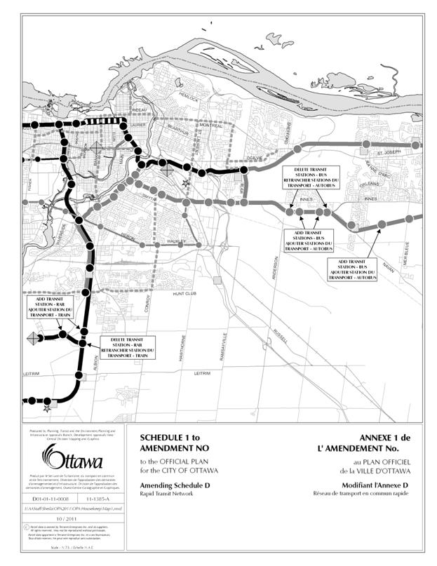
1. That Schedule 1 to the Technical Amendment be revised to
also show the addition of the EA approved transit station at Lester Road and
the future North-South LRT line.
2. That part b – The Amendment be amended to include the
following additional wording:
“Section 3.1 Generally Permitted Uses,
is hereby amended as follows:
a. by adding the words “and Municipal Services” following the
words “Public Utilities” in the title that precedes policy 9; and
b. by adding the words “and Municipal Services” following
the words “Public utility facilities” in the first line of policy 10.
(Recommendations 1 and 2 from the Planning
Committee meeting of 24 January 2012).
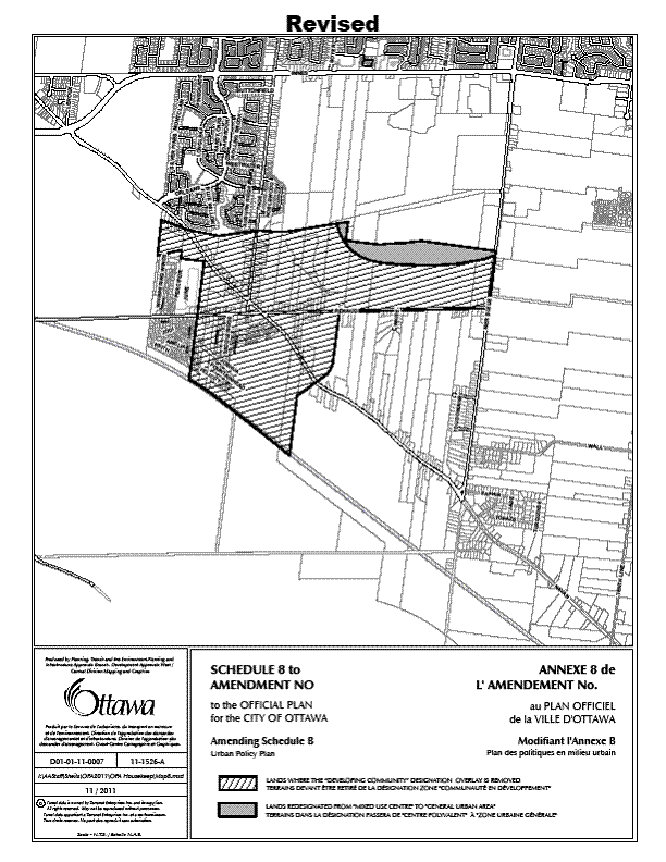
3. That
Schedule 8 to the Technical Amendment be revised to reflect the correct parcel
shapes.
RecommandationS
DE COMITÉ DE L’URBANISME ET LE RECINNANDATIONS COMITÉ DE L’AGRICULTURE ET DES
AFFAIRES RURALES MODIFIÉES DU Comité
Que le Conseil approuve
et d'adopter la modification XX au Plan officiel, qui est énoncée dans
le document 1, telle que modifiée par ce qui suit :
1. Que
l’Annexe 1 de la modification technique soit révisée pour faire état de
l’addition de la station de transport en commun approuvée par l’évaluation
environnementale sur le chemin Lester et le futur circuit nord-sud du TLR.
2. Que
la « Partie B – Modification » ssoit modifiée afin de comprendre la
formulation supplémentaire suivante :
« Partie 3.1 Utilisations
généralement permises est modifiée par la présente comme suit :
a. en
ajoutant les mots « et services municipaux » à la suite des mots
« services publics » dans le titre qui précède la politique 9;
b. en
ajoutant les mots « et services municipaux » à la suite des mots
« installations de services publics » dans la première ligne de la
politique 10 et,
(Recommandations 1 et 2 issues de la réunion du 24 janvier 2012 du
Comité de l’urbanisme).
3. Que l’Annexe 8 de la modification technique sera révisée afin de refléter
les formes correctes des parcelles.
Documentation
1. Deputy City Manager's report, Infrastructure Services and Community Sustainability, dated 13 December 2011 (ACS2012-ICS-PGM-0006).
2. Extract of Minutes
Planning Committee meetings of 24 January 2012
3. Extract of draft
minutes, Agriculture and Rural Affairs Committee meeting of
9 February
2012.
4. Extract of Draft Minutes, Planning
Committee meetings of 14 February 2012.
Report
to/Rapport au :
Planning
Committee
Comité
de l'urbanisme
and / et
Agriculture
and Rural Affairs Committee
Comité de l’agriculture et les
questionnes rurales
and Council / et au Conseil
13
December 2011 / le 13 décembre 2011
Submitted by/Soumis
par : Nancy Schepers, Deputy City
Manager
Directrice municipale
adjointe, Infrastructure Services and Community Sustainability, Services d'infrastructure et Viabilité des collectivités
Contact Person/Personne-ressource : Richard Kilstrom,
Manager/Gestionnaire
Policy Development and Urban Design/Élaboration
de la politique et conception urbaine
Planning and Growth Management/Urbanisme et Gestion de
la croissance
(613) 580-2424, 22379 Richard.Kilstrom@ottawa.ca
|
SUBJECT: |
|
|
|
|
|
OBJET : |
REPORT
RECOMMENDATION
That the Planning Committee and Agriculture and
Rural Affairs Committee recommend Council approve and adopt Official Plan
Amendment XX, as detailed in Document 1.
RECOMMANDATION DU RAPPORT
Que le Comité de
l'urbanisme et le Comité de l'agriculture et des affaires rurales recommandent
au Conseil d'approuver et d'adopter la modification XX au Plan officiel, qui
est énoncée dans le document 1.
BACKGROUND
The purpose of this Official Plan amendment is to incorporate certain policy modifications which are of a technical nature. They involve no change in land use policy direction from what is contained in the current Official Plan.
The Official Plan includes a policy (Section 5.2.3 – Public Notification, policy 3) which allows technical amendments to be made to the Official Plan, or Zoning By-law, without full public notification, provided the technical amendment is limited to correcting the following anomalies:
a. where further amendments are required to fully implement an approved recommendation of City Council to amend the Official Plan or Zoning By-law;
b. to carry forward in the Zoning By-law, the regulations of the former municipalities’ zoning by-laws, where required, to accurately harmonize those regulations;
c. to amend the language of a provision so as to clarify its intent; and
d. to eliminate unnecessary redundancies and outdated references.
The policy modifications proposed in this amendment – in the form of updates to both the text and schedules – all meet the definition of technical amendments under Section 5.2.3.
DISCUSSION
The
changes proposed through this amendment are detailed in Document 1, which
includes the text of the proposed Official Plan Amendment. The recommended changes therein are grouped
in accordance with the reason for the change: Clarification following Official Plan
Amendment (OPA) 76, Correction, or Update.
The
changes described in the category “Clarification following OPA 76” are intended
to clarify wording in the plan as a result of changes that were implemented
elsewhere as a result of OPA 76.
For example, the Ontario Municipal Board ordered that a policy be added
to Section 3.1 requiring consultation with TransCanada Pipelines Limited. This change has been incorporated into the
Plan. As a result of this change, the
proposed OPA recommends adding a reference to this new policy in the table
included in Section 4.2 that summarizes the policies that apply to lands
adjacent to land-use designations shown on Schedules A and B.
The
changes described in the “Correction” category are entirely technical in
nature, and are intended simply to correct the language of the Plan, and the
designations shown on the Schedules, to ensure that they are as accurate as
possible. For example, while the Zoning
By-law uses a lower-case “h” to indicate a holding zone, the OPA, in Section
5.2.1, policy 5, currently indicates that an upper-case “H” is used for this
purpose. This is inaccurate, and is proposed
to be corrected through this OPA.
The changes described in the “Update” category include updates that have occurred outside of the Plan, but should be corrected so that the language is as accurate as possible. For example, the Plan currently makes reference to “LACAC”, the Local Architectural and Cultural Advisory Committee, but this Advisory Committee has been renamed to “OBHAC”, the Ottawa Built Heritage Advisory Committee. The OPA described herein proposes to update this reference.
RURAL IMPLICATIONS
While this is a City-wide amendment, no specific rural implications have been identified.
CONSULTATION
In accordance with OPA policy 3 of Section 5.2.3, Public Notification, this technical amendment was not subject to the City’s Public Notification policy. Outside of the requirement to advertise in one English-language (The Ottawa Citizen) and one French-language daily newspaper (Le Droit), no further public notification was carried out.
COMMENTS BY THE WARD COUNCILLOR(S)
While this amendment was not
subject to public consultation, in keeping with the policies of Section 5.5.5
of the Official Plan, all Councillors were made aware of the amendment, and
were provided a copy. No comments were received.
LEGAL IMPLICATIONS:
As this provides a technical amendment only, it is unlikely that an appeal will be brought before the Ontario Municipal Board.
FINANCIAL IMPLICATIONS
There are no direct financial implications. In the event of an appeal, funds are available within existing resources to defend Council’s position.
ACCESSIBILITY
IMPACT
N/A
TECHNOLOGY IMPLICATIONS
CITY STRATEGIC PLAN
N/A
SUPPORTING DOCUMENTATION
Document 1 Proposed Official Plan Amendment XX - Technical
DISPOSITION
City Clerk and Solicitor Department, Legislative Services to notify the owner, applicant, OttawaScene Canada Signs, 1565 Chatelain Avenue, Ottawa, ON K1Z 8B5, Ghislain Lamarche, Program Manager, Assessment, Financial Services Branch (Mail Code: 26-76) of City Council’s decision.
Planning and Growth Management to prepare the by-law adopting the Official Plan Amendment, forward to Legal Services, and undertake the statutory notification.
Legal Services to forward the implementing by-law to City Council
PROPOSED OFFICIAL PLAN AMENDMENT DOCUMENT 1
|
|

Official Plan Amendment No. XX
To the Official Plan of the City of Ottawa
Land use
Utilisation du sol
________________________________________________________________________
INDEX
THE STATEMENT OF COMPONENTS
PART A – THE PREAMBLE
Purpose
Location
Basis
PART B – THE AMENDMENT
Introduction
Details of the Amendment
Implementation and Interpretation
PART A – THE PREAMBLE
Purpose
The purpose of this technical amendment is to update the Official Plan through technical corrections, clarification and update in advance of the 2014 Official Plan Review.
Location
This Official Plan Amendment affects the entire area of the City of Ottawa, as shown on Official Plan Schedule A: Rural Policy Plan and Official Plan Schedule B: Urban Policy Plan.
Basis
This section of the preamble to the proposed Official Plan Amendment explains why the amendments are proposed, whereas Part B includes the technical amendments that will be applied to the Official Plan, if approved. The proposed changes are grouped into three categories here, but are listed numerically in Part B.
CLARIFICATION FOLLOWING OPA 76
Section 2.3.1,
policy 21
Transportation
The proposed
amendment recommends the addition of wording to cross reference transit
right-of-way widening policies found in the note accompanying Schedule 4 –
Primary Transit Network.
Section 3.1, policies 9 and 10 Generally Permitted Uses
The proposed amendment recommends wording changes to Section 3.1 to clarify the public utilities and municipal services that policies 9 and 10, as amended by OPA 76, apply to.
Section 3.2.2 Natural Environment Areas
The proposed amendment recommends working changes to the preamble of Section 3.2.2, as amended by OPA 76, to clarify the language regarding the natural heritage system.
Section 4.2 Adjacent to Land-Use Designations
The proposed amendment recommends a change to the table included in Section 4.2, as amended by OPA 76, to identify when development proponents should engage in pre-consultation with Trans-Canada Pipelines Limited.
Section 4.7 Environmental Protection
The proposed amendment recommends changes to the table included in Section 4.7, as amended by OPA 76 to clarify the requirements for studies and assessments in order to assess development applications.
Section 4.7.3, policy 5 Erosion Prevention and Protection of Surface Water
The proposed amendment recommends including a reference to policy 4 in the text of policy 5, as amended by OPA 76, to clarify the intent of the policy.
CORRECTION
Section 5.2.1, policy 5 Implementation
Mechanisms, by Authority under the Planning
Act
The proposed amendment includes a correction to remove the words “South and East of the Canadian Shield” from the Significant Wetlands designation.
Section 5.2.1, policy 12 Implementation Mechanisms, by Authority under the Planning Act
The proposed amendment includes a correction to indicate that a holding symbol in the Zoning By-law is shown through a lower-case “h”, rather than an upper-case “H”, which is used to indicate maximum height limits.
Schedule A Rural Policy Plan
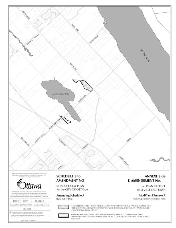
The proposed amendment includes a recommendation to adjust the Natural Environmnent Area boundary near Constance Lake to be consistent with the boundary in the Comprehensive Zoning By-law.
Schedule B Urban Policy Plan
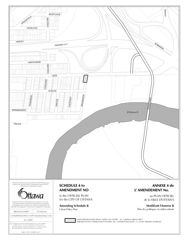
The proposed amendment includes a recommendation to align the northwest boundary of the Mixed-Use Centre at Lees Avenue and Highway 417 with Brunswick Avenue to reflect its actual shape. This will require re-designating a portion of land from Mixed-Use Centre to General Urban Area.
Schedule B Urban Policy Plan
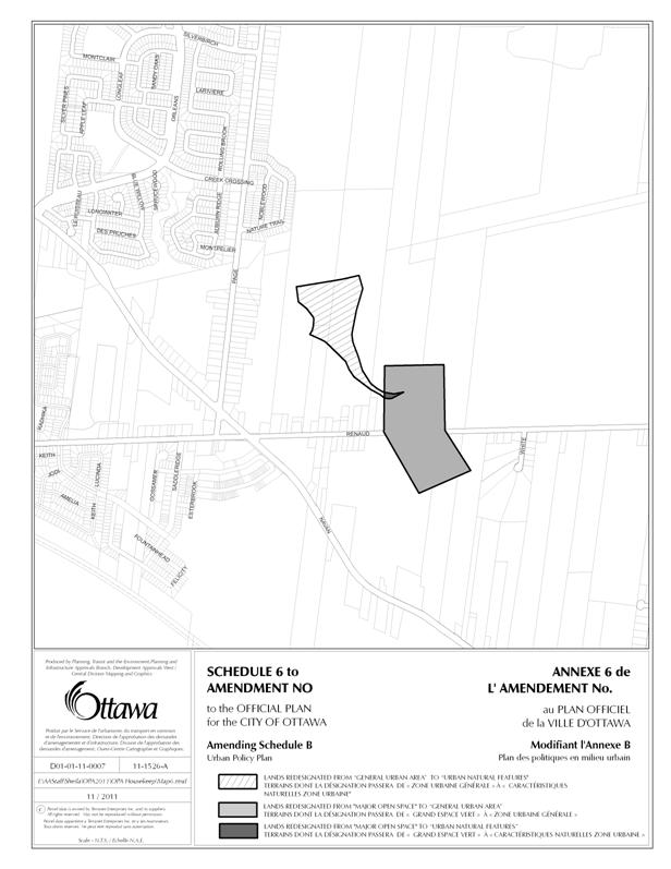
The proposed amendment includes a recommendation to update the Urban Policy Plan to reflect current designations as a result of City ownership. This will require re-designating a portion of land from Major Open Space to General Urban Area, and a portion of land from General Urban Area to Urban Natural Features.
Schedule B Urban Policy Plan
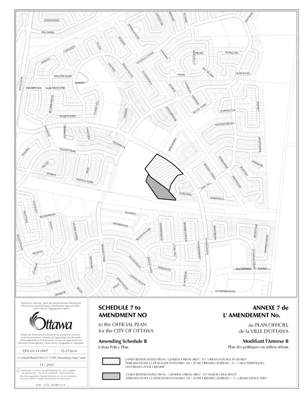
The proposed amendment includes a recommendation to update the Urban Policy Plan to reflect current designations as a result of City ownership. This will require re-designating a portion of land from General Urban Area to Urban Natural Features.
Schedule B Urban Policy Plan
The proposed amendment includes a recommendation to remove the Developing Community designation from Phase 1 of the East Urban Community. This will require re-designating the lands from Developing Community to General Urban Area.
Schedule B Urban Policy Plan
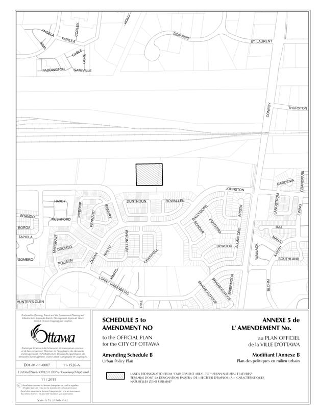
The proposed amendment includes a recommendation to remove the Employment Area designation from a portion of the lands municipally known as 1991 Johnston Road. This will require re-designating the lands from Employment Area to Urban Natural Features. The subject lands, which are City-owned, form part of the Greenboro Turtlehead Nature Area, and have been evaluated and identified as Urban Natural Area (UNA) 151 (Conroy Swamp).
Schedule D Primary Transit Network
The proposed amendment recommends a correction to the location of the Lester LRT station on the North-South (N-S) LRT line from the currently shown incorrect location at the future “T” junction of the N-S and airport spur line to a location, per the N-S Environmental Assessment, further west near the Lester/Uplands intersection. The amendment further recommends a change to add a transitway station along the Cumberland Transitway at the future extension of Belcourt Boulevard, which has been planned but which was had not yet been shown on Schedule D.
Schedule F Central Area/Inner City Road Network
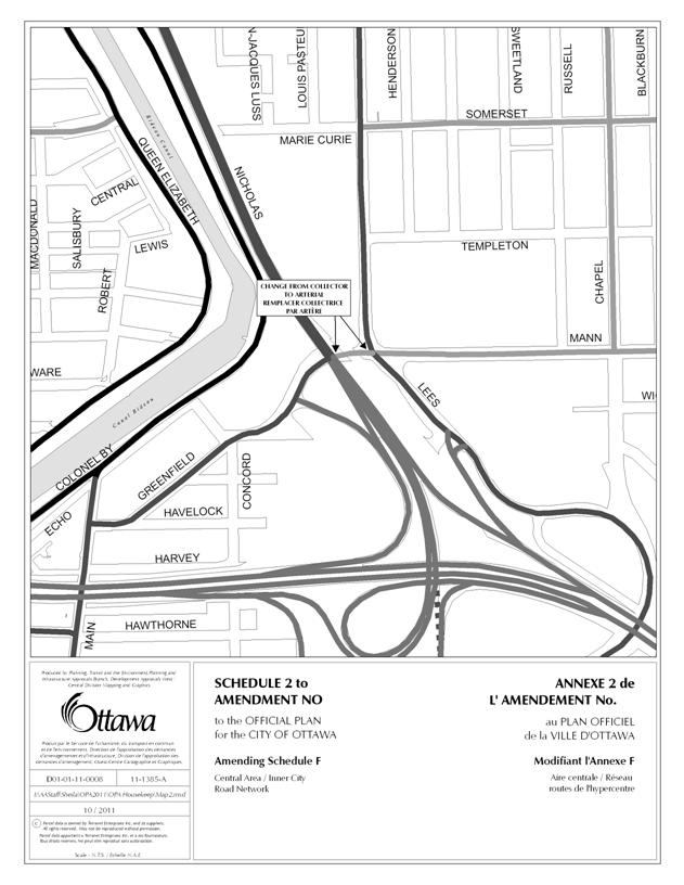
The proposed amendment recommends a correction of the road classification from collector to arterial of a 35 metre section of Mann Avenue west of the King Edward intersection to the Nicholas overpass. The roadway is an arterial on the west side of the overpass as it continues on to join Greenfield Avenue and Main Street. Mann Avenue is only a collector east of the King Edward intersection, not west of it.
Annex 1 Road Classification and Rights-of-Way
The proposed amendment revises Table 1 – Road Right of Way Protection to reintroduce the ROW widening requirements for select rural arterial roadways that lead to, or are near, the urban boundary. These roadways were in OPA No. 76 as adopted by Council, but by error were not in the version sent to and approved by Ministry of Municipal Affairs. Similarly this amendment would add back in two 23-metre ROW village arterial segments that were omitted in OPA No. 76 and by consequence the 30-metre non-village standard, which is inappropriate, currently applies. This revision applies to portions of the following roadways: Bankfield, Carp, Eagleson, Earl Armstrong, Fallowfield, Frank Kenny, Huntmar, March, Mitch Owens, Navan, Old Montreal, Prince of Wales and Richmond.
UPDATE
Section 4.4.2.4 Small Water and Wastewater Works
The proposed amendment recommends adding a new policy to clarify the original intent of the policy, being that small water and wastewater works may be permitted for commercial uses.
Section 4.7.3, policy 11 Erosion Prevention and Protection of Surface Water
The proposed amendment recommends updating a reference, in policy 11, to the “Fill, Construction and Alteration to Waterways regulation” with the “Development, Interference with Wetlands and Alterations to Shorelines and Watercourses Regulation”.
Section 4.8.3, policies 2 and 3 Unstable Soils and Bedrock
The proposed amendment recommends a change to the text of policies 2 and 3, as amended by OPA 76, to be more consistent with the Provincial Policy Statement (2005).
Cultural Heritage
The proposed amendment includes a recommendation to update references to three cultural heritage terms, wherever they appear throughout the Official Plan. This will require the removal and replacement of the following terms:
(i) Local Architectural and Conservation Advisory Committee (LACAC) to be removed, and replaced with Ottawa Built Heritage Advisory Committee (OBHAC);
(ii) Heritage Impact Statement to be removed and replaced with Cultural Heritage Impact Statement; and
(iii) Heritage Act to be removed and replaced with Ontario Heritage Act.
Schedule D Primary Transit Network
The proposed amendment recommends minor revisions to the shown locations of two future Transitway stations south of Blackburn Hamlet as per the recently completed Environmental Assessment for the Hospital Link and Cumberland Transitway Westerly Planning Study.
Annex 1 Road Classification and Rights-of-Way
The amendment recommends a number of modifications to Table 1 – Road Right-of-Way to incorporate changes, such as:
1. correction of street names, e.g. White not Whaite, Lévis not Lewis, Blackburn Hamlet By-pass extension is now Brian Coburn Boulevard, or correction of direction, e.g. “east” of Fourth line not “west”.
2. removals or shortening of road segment descriptions, e.g. between streets A and C becomes between streets A and B. These changes are required, for example, due to a widening having been obtained, it being determined that a widening is not needed due to the existing ROW meeting the requirement, or it being determined that a lesser ROW width would suffice.
3. consolidation of adjacent segments with the same ROW widening requirement; e.g. instead of two listings A to B and B to C, indicating one listing of A to C.
4. Similar segment naming adjustment is done to reflect road classification changes.
PART B – THE AMENDMENT
1. Introduction
All of this part of the document entitled Part B - The Amendment, consisting of the following text and the attached maps designated as Schedules “1” to “8” to Amendment No. __, constitutes Amendment __ to the Official Plan of the City of Ottawa.
2. Details
The Official Plan for the City of Ottawa is hereby amended as follows:
1. Section 2.2.2 Managing Growth in the Urban Area, policy 9 is hereby amended by adding the word “Ontario” before the words “Heritage Act” in the two locations in which they occur.
2. Section 2.3.1 Transportation, policy 21 is hereby amended by adding the following new sentence at the end: “Reference should be made to Schedule 4 – Rapid Transit Network and its accompanying notes.”
3. Section 2.5.5 Cultural Heritage Resources is hereby amended:
(a) in policy 2 by adding the word “Ontario” before the words “Heritage Act” where they occur;
(b) in policy 3 by adding the word “Ontario” before the words “Heritage Act” where they occur;
(c) in policy 4 by adding the word “Ontario” before the words “Heritage Act” where they occur;
(d) in policy 6 by:
(i) replacing the words “Local Architectural Conservation Advisory Committee (LACAC)” following the words “known as the”, with the words “Ottawa Built Heritage Advisory Committee (OBHAC)”;
(ii) adding the word “Ontario” before the words “Heritage Act”; and
(iii) italicizing the words “Heritage Act”.
(e) in policy 7 by adding the word “Ontario” before the words “Heritage Act” where they occur;
(f) in policy 8 by adding the word “Ontario” before the words “Heritage Act” where they occur;
(g) in policy 12(b) by adding the word “Ontario” before the words “Heritage Act” where they occur;
(h) in policy 13 by adding the word “Ontario” before the words “Heritage Act” where they occur; and
(i) in policy 22(a) by adding the word “Ontario” before the words “Heritage Act” where they occur.
4. Section 3.2.2 Natural Environment Areas is hereby amended by deleting the first three preamble paragraphs, and replacing them with the following two paragraphs:
“The Natural Environment Area designation applies to land having a high environmental value as assessed through federal, provincial and municipal studies. The lands within this designation typically contain several components of the City’s natural heritage system, including wetlands, significant woodlands, and wildlife habitat. These areas are among the most significant in Ottawa in terms of maintaining biodiversity and ecological functions. As such, development within and adjacent to these areas could unduly stress significant natural features and their ecological functions and careful management, restoration and enhancement are required.
The Natural Environment Area designation includes areas identified by the Province as significant Areas of Natural Scientific Interest (Life Science), such as Green’s Creek in the eastern area of the Greenbelt and Torbolton Forest near Constance Bay, as areas that are significant in the larger area that includes the City of Ottawa.”
5. Section 4.2 Adjacent to Land-Use Designations is hereby amended by
a. Inserting the following row, respecting section 3.1, above the row respecting section 3.2.1:
|
See Section |
Policy for Adjacent Designation |
Where Required |
|
3.1 |
Pre-consult withTrans-Canada Pipelines |
For development that will be located within 200 metres of a TransCanada Pipeline right-of-way or within 750 metres of a TransCanada Pipeline compressor station. |
b. adding the word “Cultural” before the words “Heritage Impact Statement” in the second column of the now sixth row, relating to section 3.4.
6. Section 4.4.2.4 Small Water and Wastewater Works is hereby amended by adding the following new policy as policy 3: “Notwithstanding policy 1, small water and wastewater works, being systems that are owned, operated and managed by a single owner for a single building or complex of buildings, may be considered for commercial uses, without the requirement of an agreement between the City and the proponent, as described in policy 2, provided the development does not contain any residential uses.”
7. Section 4.6.1 Heritage Buildings and Areas is hereby amended as follows:
a. in policy 1 by adding the word “Ontario” before the words “Heritage Act” where they occur;
b. in policy 2 by adding the word “Ontario” before the words “Heritage Act” where they occur and by italicizing the words “Heritage Act”;
c. in policy 3 by adding the word “Ontario” before the words “Heritage Act” where they occur and by italicizing the words “Heritage Act”;
d. in policy 4 by adding the word “Ontario” before the words “Heritage Act” where they occur; and
e. in policy 11 by adding the word “Ontario” before the words “Heritage Act” where they occur.
8. Section 4.6.2 Archaeological Resources policy 1 is hereby amended by italicizing the words “Ontario Heritage Act” where they occur in the first sentence.
9. Section 4.7 Environmental Protection includes a table indicating where studies/assessments may be required, depending on characteristics of the site, to assess a development application. The section is hereby amended by deleting this table, and replacing it with the following:
|
See
Section |
Studies/Assessment
Required |
Where
Required |
|
4.7.1 |
Integrated environmental review to assess
development applications |
Subdivision, site plan and rezoning
applications requiring an environmental impact statement, or tree retention
and protection plan or landscape feature assessment. [Amendment #76, August
04, 2010 |
|
4.7.2 |
Tree Conservation Report |
All plans of subdivision, plans of
condominium, and site plans |
|
4.7.3 |
Determine appropriate setback from rivers,
lakes, streams, and other surface water features |
Adjacent to rivers, lakes, streams, and
other surface water features |
|
4.7.3 |
Erosion and sediment control plan |
All development proposals |
|
4.7.3 |
Demonstrate no negative impact on fish
habitat; if there is impact – review by Department of Fisheries and
Oceans |
In or adjacent to fish habitat |
|
4.7.4 |
Environmental impact statement to demonstrate
no impact on the significant habitat of endangered and threatened species or
on its ecological functions |
On lands adjacent to significant habitat of
endangered and threatened species. |
|
4.7.5 |
Groundwater impact assessment |
Groundwater resources areas (to be defined
in future studies) |
|
4.7.5 |
Wellhead protection study |
Wellhead Protection Area designated on
Schedule K |
|
4.7.6 |
Stormwater site management plans |
Site plan, subdivision, and zoning
applications |
|
4.7.7 |
Assessment of landform feature / environmental impact statement to demonstrate
no negative impact on earth science areas of natural and scientific interest |
Geomorphic, geological and landform
features / earth science ANSIs (designated
on Schedule K) |
|
4.7.8 |
Environmental Impact Statement |
On or adjacent to elements of the natural heritage system, as required in
Section 2.4.2, or to designated Significant Wetlands, Natural Environment
Areas, Urban Natural Features and Rural Natural Features as required in
Sections 3.2.1 through 3.2.4 |
10. Section 4.7.3 Erosion Prevention and Protection of Surface Water, policy 5 is hereby amended by adding the words “under Policy 4” following the words “to the setback is requested” in the first sentence.
11. Section 4.7.3 Erosion Prevention and Protection of Surface Water, policy 11 is hereby amended by replacing the words “Fill, Construction and Alteration to Waterways regulations” with the words: “Development, Interference with Wetlands and Alterations to Shorelines and Watercourses Regulation”.
12. Section 4.8.3 Unstable Soils or Bedrock is hereby amended as follows:
a. by replacing the existing policy 2 with modified wording of the existing policy 3, as amended by OPA 76, as follows:
2. The
City will not permit development, meaning the creation of a new lot, an
amendment to the zoning by-law, change in land use, or the construction of
buildings and structures in areas with Unstable Soils or Unstable Bedrock where
the use is:
(a)
an institutional use associated with hospitals, nursing homes, pre-school,
school nurseries, day care and schools, where there is a threat to the safe
evacuation of the sick, the elderly, persons with disabilities or the young
during an emergency associated with soil instability;
(b)
essential emergency service such as that provided by fire, police and ambulance
stations and electrical substations that could be impaired in the case of soil
instability;
(c)
uses associated with the disposal, manufacture, treatment or storage of
hazardous materials; or
(d)
outdoor industrial storage.
b. by replacing the existing policy 3 with modified wording of the existing policy 2 as follows:
3. Notwithstanding policy 2 above, for uses
other than those listed in policy 2, the City will review applications for site
plan, plan of subdivision, condominium and consent in areas designated as
having unstable soils, or in other areas where there is evidence of unstable
soils or unstable bedrock, using the following criteria:
(a) There is sufficient soils and engineering
information (obtained using established standards and procedures) to indicate
that, although the site is identified as having unstable soils or unstable
bedrock, it is in fact suitable or can be made suitable for development;
(b)
Alterations to the site will not cause adverse environmental effects or aggravate
the hazard elsewhere.
(c)
Vehicles and people have a way of safely entering exiting the area during times
of erosion and other emergencies; and [Ministerial Modification 48, November
10, 2003]
13.
Section
5.2.1 General, policy 5 is hereby
amended by deleting the words “South and East of the Canadian Shield” between
the words “Significant Wetlands” and the words “Urban Natural Features”.
14.
Section
5.2.1 General, policy 12 is hereby
amended by replacing the capital H in parentheses following the words “holding
symbol”, with a lower-case h in parentheses, so the policy now reads as
follows: “The City may utilize a holding
symbol (h), in conjunction with any use designation in the zoning by-law to
specify the use to which lands shall be put to in the future, but which are now
considered premature or inappropriate for immediate development.”
Schedule
D – Primary Transit Network
15.
Schedule D – Primary Transit Network is
amended as shown on Schedule “1” of this Official Plan Amendment.
Schedule
F – Central Area / Inner City Road Network
16.
Schedule
F – Central Area / Inner City Road Network is amended as shown on Schedule “2”
of this Official Plan Amendment.
Schedule
A – Rural Policy Plan
17.
Schedule
A – Rural Policy Plan is amended as shown on Schedule “3” of this Official Plan
Amendment.
Schedule
B – Urban Policy Plan
- Schedule B – Urban Policy
Plan is amended as shown on Schedules “4” through “8” of this Official
Plan Amendment.
Annex 1 – Road Classification and Rights-of-Way
- Annex 1- Road Classification and Rights-of-Way, Table 1 – Road Right-of-Way Protection is amended to delete the text indicated with a strikeout bar and replace or add new rows and text indicated in gray highlight as shown below:
|
Road |
From |
To |
ROW
to be Protected |
Classification |
Sector |
|
Airport Parkway |
Bronson |
|
ECP |
arterial |
urban |
|
Bankfield |
Highway 416 |
100m west of Colony Heights |
34 |
arterial |
rural |
|
Bégin |
Montréal |
|
6 m east side, 9 m west
side |
local |
urban |
|
Boundary |
Russell |
South boundary of Carlsbad Springs |
23 |
arterial |
village |
|
Brian Coburn |
Blackburn Hamlet
By-pass |
Trim |
40 |
arterial |
urban |
|
Brian Coburn |
Trim |
Frank Kenny |
40 |
arterial |
rural |
|
Bren Maur |
|
Prince of Wales |
24 |
collector |
urban |
|
|
|
|
|
|
|
|
Carp |
Richardson Side |
Urban Area Limit |
37.5 |
arterial |
rural |
|
|
|
|
|
|
|
|
|
|
|
|
|
|
|
Eagleson |
Urban Area Limit |
Fallowfield |
34 |
arterial |
rural |
|
Earl Armstrong |
Bowesville |
Albion |
44.5 |
arterial |
rural |
|
Fallowfield |
Eagleson |
Moodie |
34 |
arterial |
rural |
|
Frank Kenny |
Innes |
Rockdale |
33 |
arterial |
rural |
|
Greenfield |
Main |
|
23 |
arterial |
urban |
|
Harbour |
Market |
Nicholson |
23 |
collector |
|
|
|
|
|
|
|
|
|
|
|
|
|
|
|
|
Heron |
|
Walkley |
44.5 |
arterial |
urban |
|
Hobin |
Renshaw |
Main Stittsville |
24 |
collector |
urban |
|
Huntmar |
Richardson Side |
Urban Area Limit |
37.5 |
arterial |
rural |
|
Innes |
Blackburn Hamlet
by-pass |
Blackburn Hamlet
by-pass |
34 |
|
urban |
|
Johnston
|
Bank |
Albion |
26 Note: measured
from south side |
major collector |
urban |
|
|
|
|
|
|
|
|
L’Église |
Montréal |
35 north of College |
20 |
local |
urban |
|
Lemieux |
St. Laurent |
Labelle |
30 |
arterial |
urban |
|
|
|
|
|
|
|
|
Maple Grove |
Approx. 500 m east of
Johnwoods Stittsville
Main St. |
|
|
|
urban |
|
March |
Dunrobin |
Urban Area Limit |
34 |
arterial |
rural |
|
March |
Richardson |
|
44.5 Note: An additional
5.0m on the Greenbelt side may be required to construct a rural
cross-section. |
arterial |
urban |
|
Merrivale |
South Urban Community –
|
Prince of Wales |
37.5 |
arterial |
urban |
|
|
|
|
|
|
|
|
Millview |
Arthur |
south end |
20 |
local |
village |
|
Mitch Owens |
River |
Bank |
34 |
arterial |
rural |
|
Moodie |
Urban Area Limit (Greenbelt) |
Fallowfield |
34 |
arterial |
rural |
|
Navan |
Urban Area Limit |
Trim |
34 |
arterial |
rural |
|
|
|
|
|
|
|
|
Northside |
Larkspur (west intersection) |
Cassidy |
24 |
collector |
urban |
|
Old Montréal |
East Urban Community – east limit |
Approximately 250 m west of Chevalier |
34 |
arterial |
rural |
|
|
|
|
|
|
|
|
|
|
|
|
|
|
|
Silver Seven |
Terry Fox |
|
arterial |
urban |
|
|
Patricia |
Richmond |
40 m north of Richmond |
Note: widening only on west side |
local |
urban |
|
Prince of Wales |
Urban Area Limit |
Bankfield |
40 |
arterial |
rural |
|
Preston |
|
Albert |
26 |
arterial |
urban |
|
Renaud |
150 m west of |
150 m west of Mer Bleue |
24 |
collector |
urban |
|
Rideau Terrace |
Noel |
Acacia |
Note: On south side
between Noel and Lambton 3.048 m widening required. Widening to be taken equally from each side
between Lambton and |
collector |
urban |
|
Rideau Valley |
Blue Rock |
Stevens Creek |
23 |
arterial |
village |
|
Richmond |
Hope Side |
Fallowfield |
34 |
arterial |
rural |
|
River Road |
Urban area limit |
Mitch Owens |
|
arterial |
rural |
|
Roger Stevens |
Approx. 600m west of
Craighurst (North Gower Village |
Approx. |
23 |
arterial |
village |
|
Roosevelt
|
Richmond |
Byron (Danforth) |
18 Note: west side |
local |
urban |
|
Russell |
Walkley |
Ramsayville |
G |
arterial |
urban |
|
|
|
|
|
|
|
|
Tenth Line |
|
Amiens |
44.5 |
arterial |
urban |
|
|
|
|
|
|
|
|
|
|
|
|
|
|
|
Whitby
|
Churchill |
Winona |
15 Note: North side |
local |
urban |
|
|
|
|
|
|
|


As revised by Planning Committee on 24
January 2012 (Motion No. PLC 27/3)