|
4. ZONING - 760 MARCH ROAD ZONAGE -
760, CHEMIN MARCH |
Committee
recommendationS as amended
That
Council approve:
1. An
amendment to Zoning By‑law 2008-250 to change the zoning of 760 March
Road, from Development Reserve Zone [DR] to Residential Fourth Density Subzone
Z urban exception Zone with a Schedule [R4Z(XXXX) SXXX] and Open Space Zone
with a Schedule [O1 SXXX], and amend the boundaries of the flood plain
hazard overlay, as shown in Document 1 and as detailed in Documents 2 and 3.
That
the legend of Document 1 be amended by adding after the text “R4Z[XXXX]” and
“O1” the text “SXXX” wherever they appear, so that they read “R4Z[XXXX] SXXX”
and “O1 SXXX” respectively.
That
Document 2 be amended by replacing item 1 with the following:
“1. The Zoning Map of By-law 2008-250 will be
amended by rezoning the subject lands and revising the boundaries of the flood
plain hazard overlay on the subject lands shown on Document 1 as follows:
a. Area
A from DR to R4Z[XXXX] SXXX.
b. Area
B from DR to O1 SXXX.
c. Area C from DR to O1 SXXX and over which the flood plain
hazard overlay is to be added.
d. Area D from DR to R4Z[XXXX] SXXX and from which the flood
plain hazard overlay is to be removed.”
That there be no further notice pursuant
to Section 34 (17) of the Planning Act.”
2. That the recommended zoning be amended to require parking
to meet the current zoning of 1.1 spaces per dwelling plus 0.2 visitor spaces.
RecommandationS
MODIFIÉES DU Comité
Que le Conseil approuve :
1. Une modification au Règlement de zonage no 2008-250
en vue de changer le zonage de la propriété située au 760, chemin March, de
Zone d’aménagement futur [DR] à Zone d’aménagement résidentiel de densité 4,
sous-zone Z, avec une zone d’exception urbaine assortie d’une annexe
[R4Z(XXXX) SXXX] et à Zone de parc et d’espace
vert avec annexe [O1 SXXX], et de
modifier les limites de la Zone sous-jacente de plaine à risque d’inondation, tel qu’illustré dans le document
1 et exposé en détail dans les documents 2 et 3.
Que la légende du document 1 soit modifiée par l’ajout de la mention
« SXXX » après les
textes « R4Z[XXXX] » et « O1 », de manière à ce
qu’on y lise « R4Z[XXXX] SXXX » et « O1 SXXX » respectivement.
Que le document 2 soit modifié par le remplacement du point 1 par le
texte suivant :
« 1. La carte de zonage du Règlement 2008-250 sera modifiée per un
changement de zonage du terrain visé et la révision des limites de la Zone sous-jacente de
plaine à risque d’inondation, tel qu’illustré dans le document 1 :
a. Secteur A, de DR à R4Z[XXXX] SXXX.
b. Secteur B, de DR à O1 SXXX.
c. Secteur C, de DR à O1 SXXX et sur
laquelle la zone
sous-jacente de plaine à risque d’inondation doit être ajoutée.
d. Secteur D, de DR à R4Z[XXXX] SXXX,
et d’où la zone
sous-jacente de plaine à risque d’inondation doit être enlevée. »
Qu’il n’y plus d’avis relatif à l’article 34 (17) de la Loi sur l’aménagement du territoire.
2. Que le zonage recommandé soit
modifié de manière à exiger que l’exigence de stationnement réponde à celle du
zonage actuel de 1,1 place par unité d’habitation et de 0,2 place pour
visiteur.
Documentation
1. Deputy
City Manager's report, Infrastructure
Services and Community Sustainability, dated 10 January 2012 (ACS2012-ICS-PGM-0043).
2. Extract of Draft Minutes, Planning
Committee meeting of 14 February 2012.
Report to/Rapport au :
Comité de l'urbanisme
and Council / et au Conseil
10 January 2012 / le 10 janvier 2012
Submitted by/Soumis par : Nancy Schepers, Deputy City Manager/Directrice
municipale adjointe, Infrastructure Services
and Community Sustainability/Services d’infrastructure et Viabilité des
collectivités
Contact
Person/Personne-ressource : Derrick Moodie, Acting Manager/Gestionnaire
intérimaire, Development Review-Suburban Services/Examen des projets
d'aménagement-Services suburbains, Planning and Growth Management/Urbanisme et
Gestion de la croissance
(613)
580-2424, 15134 Derrick.Moodie@ottawa.ca
|
SUBJECT: |
|
|
|
|
|
OBJET : |
REPORT RECOMMENDATION
That the Planning Committee
recommend Council approve an amendment to Zoning By‑law 2008-250 to
change the zoning of 760 March Road, from Development Reserve Zone [DR] to
Residential Fourth Density Subzone Z urban exception Zone [R4Z(XXXX)] and Open
Space Zone [O1], and amend the boundaries
of the flood plain hazard overlay, as
shown in Document 1 and as detailed in Document 2.
RECOMMANDATION
DU RAPPORT
Que le Comité de l’urbanisme
recommande au Conseil d’approuver une modification au Règlement de zonage no 2008-250
en vue de changer le zonage de la propriété située au 760, chemin March, de
Zone d’aménagement futur [DR] à Zone d’aménagement résidentiel de densité 4,
sous-zone Z, avec une zone d’exception urbaine [R4Z(XXXX)] et à Zone de parc et
d’espace vert [O1], et de modifier les limites de la Zone sous-jacente de
plaine à risque d’inondation, comme le montre le document 1 et l’explique le
document 2.
BACKGROUND
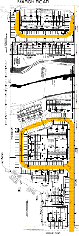
The subject property, 760 March Road, is located in Kanata North, south of Klondike Road with frontage on both March Road and Sandhill Road.
The site measures 2.87 hectares in area. The
property is currently vacant with the exception of a few mature trees.
Shirley’s Brook runs through the centre of the property, creating two separate
developable parcels; one fronting onto March Road and one fronting onto
Sandhill Road. An existing foot bridge connects the two parcels.
Surrounding uses include the St. John’s
Anglican Church and Blue Heron Cooperative Homes to the south, the Fellowship
Baptist Church, residential uses and the Morgan’s Grant Montessori School to
the north. The Klondike Crossing Shopping Centre is located across March Road
to the west. The South March Public School and Sandhill Park are located east of
the site.
Purpose of Zoning Amendment
The purpose of the proposed
amendment is to change the current Development Reserve Zone to allow for the
construction of a planned unit development consisting of 156 stacked townhouse dwelling units and four
multiple attached dwelling units. The larger
development parcel with frontage on Sandhill Road is proposed to accomodate 100
stacked townhouse dwelling units located in seven buildings. The second parcel
is proposed to accomodate 56 stacked
townhouse dwelling units located in four buildings, two of which will face
March Road. A third development parcel on Sandhill Road is proposed to
accommodate four street townhome dwelling units. A current site plan proposal
is shown in Document 5.
Existing Zoning
The lands are zoned Development Reserve (DR). The Development Reserve zone has been placed on the subject lands as they are vacant undeveloped lands located within the General Urban Area designation, on Schedule B of the Official Plan. This zone recognizes lands intended for future urban development. The types of permitted uses are limited to those that will not inhibit future development options. Generally, the existing land uses within this zone are of a low scale and density. The site is also subject to a floodplain hazard overlay which indicates the limits of the existing 100-year floodplain limits.
Proposed Zoning
The applicant is requesting to amend the current zoning in effect over the subject site to reflect its proposed site plan of a planned unit development. The proposed planned unit development consists of stacked townhouse dwelling units. The proposed zoning will also allow for street townhouse dwelling units which will be located on a separate block fronting on Sandhill Road. The areas shown as Areas A and Area D on Document 1 are proposed to be rezoned Residential Fourth Density Subzone Z urban exception Zone (R4Z [XXXX]) to accommodate the proposed dwelling unit types and associated setbacks and zoning requirements. The Residential Fourth Density Subzone Z allows for a variety of low and medium density uses including street townhouse dwelling units, stacked townhouse dwelling units and a planned unit development. The applicant is also proposing an open space zone identified as Areas B and C on Document 1 to recognize the location of Shirley’s Brook corridor. The corridor will be dedicated to the City through the Site Plan approval process. The necessary width of the creek corridor to be dedicated in this location has been determined by staff in conjunction with the Mississippi Valley Conservation Authority, and reflects the 100-year floodplain limit. In order to accurately reflect the proposed flood plain boundaries, the flood plain hazard overlay is proposed to be admended as shown on Document 1. All other portions of the flood plain hazard overlay within the subject lands will remain. This will ensure that what is proposed is accurately reflected in the Zoning By-law.
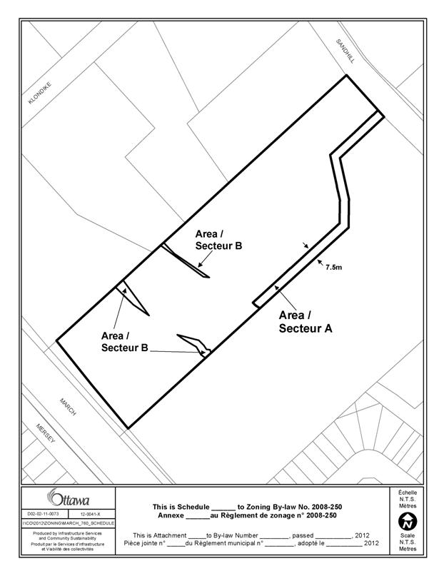
The applicant also proposes a site specific exception for the residential zone to reflect a proposed reduction in the parking requirement to one parking space per dwelling unit whereas the Zoning By-law requires 1.2 spaces. The proposed site specific exception also includes a reduction in the width of required landscape buffers for parking lots as detailed in Document 2. The proposed exception also includes a reduced minimum lot width of 12.5 metres for a planned unit development and stacked townhouse dwelling unit to reflect the proposed frontage on Sandhill Road. A new schedule (Document 3) is also recommended to incorporate a 7.5 metres landscaped heritage buffer abutting the existing St. John’s church and cemetery property. The schedule also includes a second area (Area B) to recognize three areas located beyond the proposed open space zone but within the 55-metres meander belt identified for Shirley’s Brook. No buildings are to be permitted in Area B.
DISCUSSION
Planning Act and Provincial Policy Statement
Section 2 of the Planning Act outlines those land use matters that are of provincial interest, for which all City planning decisions shall have regard. The provincial interests that apply to this site are the adequate provision of a full range of housing, and the protection of ecological systems, including natural areas, features and functions. In addition, the Planning Act requires that all City planning decisions be consistent with the Provincial Policy Statement (PPS), a document that provides further policies on matters of provincial interest related to land use development. Section 1.1.1 of the PPS addresses healthy, liveable and safe communities. Specifically, planning authorities are to accommodate an appropriate range and mix of residential, employment, recreational and open space uses to meet long-term needs. Section 1.4 of the PPS is also of particular importance in light of the proposed amendment, as it requires planning authorities to provide for an appropriate range of housing types and densities required to meet projected requirements of current and future residents of the regional market area.
The proposed residential use for the subject site meets the intent of both the Planning Act and the Provincial Policy Statement on the basis that it helps provide a range of residential densities and housing types in the community. The proposed rezoning also ensures the protection of natural features found on the subject site, by way of rezoning these areas to an Open Space zone designation to ensure their protection and to limit any future development on this land.
Official Plan
The subject lands are designated
General Urban Area on Schedule B of the Official Plan. The General Urban Area
designation allows for a variety of uses, including a range of residential uses
and densities. The proposed use meets the intent of the General Urban Area
Designation. In
accordance with Section 3.6.1 of the Plan, all types and densities of housing,
as well as employment, shopping, service, leisure and parks and natural areas,
are permitted within areas designated General Urban Area. Although the lands are not within the
“Developing Community” designation, such policies were used as guidance for
this development. The proposed
development has a net residential density of 68 dwelling units per hectare,
which exceeds the minimum requirement for the Developing Communities
designation of 34 units per hectare. The proposed Zoning By-law amendment meets
the intent of Section 3.6.1 on the basis that it allows for a form of
residential development which acheives a mix of housing types in the community.
The proposed Zoning By-law amendment also meets the objectives of the
Environmental Protection Policy 4.7.
Shirley’s Brook, which bisects the property, will be protected as part
of the planned development for this
property. Specifically, a creek corridor reflecting the proposed 100-year flood
plain limit will be dedicated to the City to protect this resource and
associated flood plain lands.
Compatibility
Section 2.5.1 of the Official Plan provides guidance with respect to creating and fostering compatible development. The section states “compatible development means development that although it is not necessarily the same as or similar to the existing buildings in the vicinity, nonetheless enhances the established community and coexists with the existing development without causing undue adverse impact on surrounding properties”. The surrounding land uses include a mix of residential densities in both the Briarbrook and Morgan’s Grant communities and a wide variety of commercial and institutional uses. The proposed development is compatible with the adjacent church property and four-storey low-rise apartment building to the south. In order to ensure compatibility with the low density residential properties located to the north, the applicant has provided a 12.3-metres driveway which may ultimately be augmented and dedicated as a public right-of-way, if and when the properties to the north are re-developed for more urban forms of development. The stacked townhouse units have also been oriented to allow for the balconies to face away from low density residential properties, to reduce the perception of invasion of privacy and potential noise. The applicant is also proposing four street townhouse dwelling units fronting on Sandhill Road to respect the current character of the streetscape. The proposed building materials, heights, massing and landscaping of the development are all in keeping with the low to medium density residential character of the surrounding community. On this basis, the proposed rezoning meets the intent of Section 2.5.1 of the Official Plan.
Section 4.11 provides additional guidance when evaluating planning applications for compatibility. The proposed development meets all of the criteria outlined in Section 4.11. The following key considerations have been applied to the proposed rezoning to ensure the intent of Section 4.11 has been met.
Traffic/Transportation Considerations. The proposed development
fronts onto March Road, which is an arterial road, and Sandhill Road, which is
a collector road as identified on Schedule E of the Official Plan; both of
these roads have been determined to have the ability to accommodate traffic
generated by users of the site. A Transportation Study concludes that the roads
serving the subject property have sufficient capacity to accommodate the
proposed development. Both
the AM and PM peak periods have been reviewed in the Transportation Study. The Transportation Association of Canada (TAC)
guidelines identify collector road thresholds as being less than 8000 vehicles
per day (800 per hour). The 2019 projected total traffic on Sandhill Road
is 141 vehicles west of the site and 153 vehicles east of the site in the AM
peak hour and 119 vehicles east of the site and 132 vehicles west of the site
in the PM peak hour, which is well below the acceptable threshold. The peak
hour is the accepted industry highest hour for traffic analysis and impact.
Pedestrian connectivity through the site is proposed to be provided by way of the proposed stonedust pathway and upgraded footbridge through Shirley’s Brook corridor. This will allow for residents in both areas of the site to access the commercial uses located on the opposite side of March Road and future bus-rapid transit. The access will also allow residents to access South March Public School and parkland located on the opposite side of Sandhill Road. Sidewalks are located on both March Road and Sandhill Road.
Noise, Odours and Other Emissions. It is not expected that the
proposed development will generate noise, odours and other emissions. Due in
part to comments provided through public consultation, two of the stacked
townhouse blocks have been re-oriented such that the balconies face away from
existing residential uses on Billingham Crescent and the St. John’s cemetery to
the greatest extent possible. Garbage is proposed to be contained within two
enclosures to reduce the potential for odours.
Servicing Considerations. The subject property will be connected to
both municipal water and wastewater facilities. The existing services are
adequate to accommodate the proposed development.
Environmental
Considerations. The proposed Zoning By-law amendment also meets the
requirements of the Official Plan’s Environmental Protection Policy 4.7. The stretch of Shirley’s Brook which bisects
the property, will be protected as a requirement of the proposed plan.
Specifically, a corridor, which reflects the proposed 100-year floodplain limit,
will be dedicated to the City to protect this resource. The applicant has
worked closely with the Conservation Authority to determine the flood line shown on Document 1 using
the existing floodplain mapping and cross sectional information provided by the
Conservation Authority and updated topographical information. A cut and fill permit
from the Conservation Authority will be required for the minor floodplain
alteration in advance of Site Plan approval. All lands located within the flood
plain as shown on Document 1 are to be zoned Open Space (01) to ensure that
development is prohibitted within these lands. The Shirley’s Brook
Environmental Management Plan also identifies a required meander belt for this
segment of Shirley’s Brook. The identified meander belt is identified to have a
range in width from 40 metres at a minimum to 55 metres maximum. The majority
of the 55-metres meander belt is located within the proposed floodplain limits
to be dedicated to the City. Three small areas identifed as part of the maximum
55-metres meander belt are located beyond the 100-year floodplain limit. These
areas will be identified on the proposed site plan, and restrictions will be placed on title to ensure that no buildings be
located within these three areas. These three areas have been identified on
Schedule (XXX) as Area B. No buildings shall be permitted within them. The
applicant is proposing to enhance the creek corridor by providing extensive
riparian plantings as detailed in their site plan application.
Details of Proposed Zoning
The applicant is proposing to rezone Area A as
shown on Document 1 from DR to R4Z[XXXX] and Area B from DR to O1. The proposed
R4Z[XXXX] zoning will permit a planned unit development as proposed by the
applicant. The proposed planned unit development is shown in Document 5. The
proposed R4Z zone also includes provisions for low-rise apartment dwelling
units, stacked townhouse dwelling units, street townhouse dwelling units and a
variety of other dwelling types.
In order to reflect the applicant’s proposed
site plan, an urban exception zone is recommended. The urban exception zone is
requested to amend two Zoning By-law provisions and also includes a provision
for a 7.5 metres landscaped heritage buffer abutting the St. John’s Church property
and a provision for the prohibition of buildings within the 55-metres meander
belt of Shirley’s Brook.
Due to the location of a proposed freehold
block of four freehold townhomes on Sandhill Road, the frontage provided for
the proposed planned unit development is reduced to 12.5 metres to accommodate
a private street entrance. This reduction is necessary in order to accommodate
the townhouses on Sandhill Road, which provide for a continuous streetscape.
Areas C and D reflect the proposed alterations
to the floodplain overlay, in order to accurately reflect the amended
floodplain boundaries as proposed. The areas identified as Area C will be added
to the existing overlay and the areas identified as Area D will be removed.
Parking
The first requested exception pertains to the
required parking rate for the subject site. The Zoning By-law currently
requires 1.2 spaces per dwelling unit for a stacked townhouse, in accordance
with Table 101 of Zoning By-law 2008-250. The by-law also requires an
additional 0.2 visitor parking spaces be provided per dwelling unit on-site.
The applicant is proposing to reduce the parking requirement to 1.0 spaces per
dwelling unit, but is not proposing to amend the visitor parking space
requirement. The proposed site plan includes a surplus of 20 visitor parking
spaces, for a total of 51 visitor spaces, which exceeds the minimum requirement.
The reduction in parking is appropriate given the proximity of existing and future transit as well as the availability of public and commercial spaces close to the site. To ensure that no spill over parking onto Sandhill Road occurs, the surplus of 20 visitor parking spaces is to be provided to meet the needs of those visiting the site. Each residential unit will be assigned one parking space. The provided parking is in keeping with other residential uses in the community. Only one parking space is required for detached, semi-detached and townhouse dwelling units, all of which are typically larger dwelling unit types. The proposed stacked townhouse dwelling units are to be assigned with one parking space per dwelling unit. Enforcement of parking within the condominium will be at the discretion of the condominium corporation. All municipal parking by-laws apply to parking on Sandhill Road and will be enforced accordingly.
An Environmental Assessment is currently
underway for a future bus rapid transit route along March Road. This transit
route will include a station within 600 metres of the subject site, allowing
for strong transit use possibilities for residents. Currently, All Day Route 93
located on Klondike Road and Express Route 60 located on Flamborough Way serve the
subject site. Route 93 provides an all day connection to Bayshore Transit
Station and Route 60 provides a direct service to the downtown core in the AM
and return in the PM for future residents. Therefore, staff support the
proposed reduction in the parking requirement, on the basis of transit
availability, a surplus of at least 20 visitor parking spaces, and the
pedestrian connectivity of the site.
Landscape Buffer Requirements for
a Parking Lot
The second requested exception pertains to the landscape buffer requirements for a parking lot. The Zoning By-law currently requires a landscaped buffer of 3.0 metres abutting a property line for a parking lot containing more than 100 parking spaces. The By-law also requires a 1.5-metres landscaped buffer abutting a property line for a parking lot containing between 10 and 100 parking spaces. The applicant is requesting reductions to both requirements. There are two proposed parking lots on the subject lands. The first parking lot is accessed from March Road and contains 94 parking spaces. The southern boundary of the parking lot abuts the Blue Heron Co-operative Housing parking lot. The applicant is proposing to reduce the required buffer to 1.0 metres in this location, a reduction of 0.5 metres. In lieu of providing a full 1.5 metres, the proposal is to provide landscaping between the two parking lots on both properties. This will achieve an overall landscaped buffer greater than 1.5 metres. As a result, the intent of the by-law is maintained, and staff support the proposed reduction.
The larger parking area is accessed from Sandhill Road and contains 113 parking spaces. The applicant is proposing to locate a drive aisle along the northern edge of the site with a landscape buffer of 1.5 metres and a fence in lieu of the required 3.0 metres. The combination of a fence and landscaping meets the intent of the zoning by-law. It should also be noted that no parking spaces are proposed abutting the buffer; it is only the drive aisle that is proposed in this location. Therefore, staff support the proposed reduction in the required landscaped buffer.
Heritage Considerations/Heritage Buffer
St.
John’s Anglican Church and Cemetery is designated under Part IV of the Ontario Heritage Act and abuts the
southern property boundary of the subject site. When a development is proposed
adjacent to a heritage resource, Official Plan policy 4.6.1 requires that
applicants demonstrate that the proposal is compatible with the heritage
resource. Planning
staff in conjunction with the applicant, agree that a 7.5 metres landscaped
heritage buffer would be appropriate between the property line abutting the
cemetery and any proposed building. This buffer space will allow for additional
plantings and a continuation of the existing hedge which borders the cemetery.
No building or structure shall be located within the heritage buffer. Schedule
A as shown in Document 3 illustrates the proposed location of the buffer.
Conclusion
The proposed residential use is considered appropriate
for the site, and will achieve the goal of providing a full range and choice of
housing types in the community. Further,
the location on both a collector and an arterial road is considered an appropriate
location for a medium density development, while
respecting the existing character of the community. The proposal makes use of
existing services, and is supportive of transit and pedestrian use. The
Department supports this Zoning By-law amendment because the proposed use is
compatible with the surrounding area and conforms to the applicable policies
outlined within the Provincial Policy Statement and the Official Plan.
Concurrent Application
The proposed planned unit development and street townhouse units are subject to an active Site Plan Application, file no. D07-12-11-164.
RURAL IMPLICATIONS
N/A
CONSULTATION
Notice of this application was carried out in accordance with the City's Public Notification and Consultation Policy. The public consultation undertaken and the comments received are summarized in Document 4.
COMMENTS BY THE WARD COUNCILLOR(S)
Councillor Wilkinson is aware of the application.
LEGAL IMPLICATIONS
Should this matter be appealed to the Ontario Municipal Board, it is anticipated that a two day hearing would be required. In the event, the recommendation is adopted, this hearing could be conducted within staff resources. Should the recommendation be refused, reasons must be provided. Were there an appeal, it would be necessary to retain an outside planner and likely an outside transportation consultant at a total estimated cost of $40,000 to $50,000.
RISK MANAGEMENT IMPLICATIONS
There are no risk implications.
FINANCIAL IMPLICATIONS
In the event of an appeal, it would be necessary to retain an outside planner and likely an outside transportation consultant at a total estimated cost of $40,000 to $50,000. Funds are not available from within existing resources, this expense would impact Planning and Growth Management’s 2012 operating status.
ACCESSIBILITY IMPACT
TECHNOLOGY IMPLICATIONS
CITY STRATEGIC PLAN
The City’s Strategic Plan promotes Healthy and
Caring Communities which provide a high quality of life and contribute to community
well-being through healthy, safe, secure, accessible and inclusive places. The
Strategic Plan also calls for long-term sustainability and reductions to the
city’s environmental footprint by maintaining and improving the quality of the
air and water, by utilizing green technology and promoting energy efficiency,
and by protecting the natural resources and land to enhance the quality of the
environment for residents. The proposed rezoning respects both of these goals,
by providing a range of safe, healthy, energy efficient, and affordable housing
options, and by ensuring that the local watercourse and floodplain are
protected.
APPLICATION PROCESS TIMELINE STATUS
This application was processed by the "On Time Decision Date" established for the processing of Zoning By-law amendment applications.
SUPPORTING DOCUMENTATION
Document 1 Location Map
Document 2 Details of Recommended Zoning
Document 3 Zoning Schedule (XXX)
Document 4 Consultation Details
Document 5 Proposed Site Plan
DISPOSITION
City Clerk and Solicitor Department, Legislative Services to notify the owner, applicant, OttawaScene Canada Signs, 1565 Chatelain Avenue, Ottawa, ON K1Z 8B5, Ghislain Lamarche, Program Manager, Assessment, Financial Services Branch (Mail Code: 26-76) of City Council’s decision.
Planning and Growth Management to prepare the implementing by-law, forward to Legal Services and undertake the statutory notification.
Legal Services to forward the implementing by-law to City Council.
LOCATION MAP DOCUMENT
1
DETAILS OF RECOMMENDED ZONING DOCUMENT 2
1. The Zoning Map of By-law 2008-250 will be
amended by rezoning the subject lands and revising the boundaries of the
flood plain hazard overlay on the subject lands shown on Document 1 as follows:
a. Area
A from DR to R4Z[XXXX].
b. Area
B from DR to O1.
c. Area
C from DR to O1 and over which the flood plain hazard overlay is to be added.
d. Area
D from DR to R4Z[XXXX] and from which the flood plain hazard overlay is to be
removed.
2. Section 239 – Urban Exceptions will be
amended by adding a new exception with provisions similar in effect to the
following:
- Notwithstanding Table 101 Row (r), Column IV the minimum required
number of parking spaces for a stacked dwelling is 1 per dwelling unit.
- Notwithstanding Table 162a Row (Z), Column IV, the minimum required lot
width for a planned unit development is 12.5 metres.
- Notwithstanding Table 162a Row (Z), Column IV, the minimum required lot
width for a stacked dwelling unit is 12.5 metres.
- Notwithstanding Table 110 Row (b), the minimum required width of a
landscape buffer not abutting a street for:
(i) a parking lot containing between 10 and
100 parking spaces is 1.0 metres; and,
(ii) a parking lot containing more than 100
parking spaces is 1.5 metres.
- All of Area A on Schedule XXX must be landscaped with soft landscaping and no buildings and structures are permitted.
-
No buildings are permitted within Area B on Schedule XXX.
3. Add
to Part 17 - Schedules Document 3 as Schedule XXX.
SCHEDULE (XXX) DOCUMENT
3
CONSULTATION DETAILS DOCUMENT 4
NOTIFICATION AND CONSULTATION PROCESS
Notification and public consultation was undertaken in accordance with the Public Notification and Public Consultation Policy approved by City Council for Zoning By-law amendments. One public meeting/information session was also held in the community on November 24, 2011.
PUBLIC COMMENTS
1. Comment: I am writing to tell you that I am definitely against the
re-zoning on Sandhill Road. so that Minto can build Terrace Homes on this
property. First of all the increase of traffic will be phenomenal, not
only on Sandhill Road but also on Klondike Road. This will cause many
safety problems, not just for children, but also for seniors that live in this
area. Hopefully the City of Ottawa will be able to come to a better solution
for this property.
Staff Response: The
proposed development fronts onto March Road, which is an arterial road, and
Sandhill Road, which is a collector road; both of these roads have been
determined to have the ability to accommodate traffic generated by users of the
site. The Transportation Study, concludes that the roads serving the subject
property have sufficient capacity to accommodate the proposed development.
Staff accept the report conclusions.
2. Comment: I would like to voice my objection to the Site Plan
Application for this piece of land. While I have no objection to it being
developed for residential purposes, I feel the density proposed is far too high
to integrate well into the surrounding community. I live on Billingham
Crescent, and the homes on the west side of it, of which mine is one, will back
on to this new development, with only three large properties between us, most
of which are comprised of land, the buildings or dwellings on them being close
to Sandhill Road, thus not able to block noise. We on Billingham Crescent will
be subject to a lot of noise from so many dwellings in such close proximity to
each other, especially in summer when sounds carry farther and people /
children are outside more often. Another concern is the increased traffic on
Sandhill Road. It was not built to handle the amount of traffic it is now being
asked to. Between residents of the large Brookside development, and the
residents of this new development which is proposed, there will be more traffic
than the road should sustain. It was never intended as a major artery. Also, as
the sightline looking left onto Sandhill Road from the west intersection of
Billingham Crescent and Sandhill Road is quite poor due to a curve in Sandhill
Road at that point, and further reduced in winter due to snow banks, the
increased traffic will make it more difficult for residents of the west side of
Billingham Crescent to exit the street onto Sandhill Road. These homes will be attractive to first-time
buyers and young families. The reality is that the combination of both in such
a high-density development will create both noise and traffic congestion. I
would like the City to consider lowering the number of residences to be built
on the land in question.
Staff Response: It is not expected that the proposed development will generate noise, odours and other emissions. In addition, due in part to comments provided through public consultation, two of the stacked townhouse blocks have been re-oriented such that the balconies are positioned away from existing residential properties on Billingham Crescent and the St. John’s cemetery to the greatest extent possible.
Sandhill Road is designated as a collector road in the Official Plan and has been designed to accommodate the anticipated volume of traffic.
3. Comment: I and my wife are the property owners at 351 Sandhill Road,
just beside, and on the north of Minto's proposed
development. We met with Minto planners today and discussed development
alternatives. We all agreed that we could have the side of our property
filled in to a level with Minto's, with the addition of
a tall solid fence installed by Minto, up to the city edge of Sandhill Road.
They plan a 6-foot wood fence, while we request making it
higher, in plastic or cement.
Our second request is the access road in from Sandhill Road.
The current plan shows it directly parallel to our property, and running its
whole length and beyond. However, it needs to be closer to the
Church (graveyard) side of the Minto development, to shield us from
the traffic noise. We were advised by the Minto planners that they
have a site plan that would accommodate that change, resulting in an access
road with a bend. That would slow the traffic from the straightaway originally
proposed, but would not reduce overall housing. It may be noted that the
public school on Sandhill Road would also benefit from having the access road
closer to the Church. This would put more distance between its
side, stair-case walkway entrance on Sandhill Road, and this traffic
entrance.
Staff Response: A 1.8 metres high fence is proposed to be
provided abutting 351 Sandhill Road. The materials, height and associated
landscaping can be addressed through the associated Site Plan Approval Process.
The applicant is aware of the request for alternative material and a higher
fence.
The location of the access on Sandhill Road has been utilized to both
respect the 7.5 metres heritage buffer and to allow for the possible future
re-development of 351 Sandhill Road. The intent is to allow for the possibility
of a future 16.5 metres public right-of-way in this location, to be utilized by
both properties for access.
4. Comment: Further to our
discussion at the Community Information Session meeting Thursday, November
24th, 2011 regarding the proposed Minto project located off Sandhill Road and
directly bordering the St John's Anglican Church cemetery, I would submit the
following suggestions that were discussed at the meeting.
The cemetery is a spiritual and
solemn location and should remain as private as possible. A quiet garden
has been constructed for meditation and prayerful thought. As pointed out
at the meeting, members of the St John's congregation are aware and are worried
about the size and height of the proposed residences adjacent to the
cemetery. Block 9 and Block 10 are planned to be 4.5-storey terrace
homes.
The plan that would be more
acceptable is to change both blocks to two storey townhomes to match the
townhomes to be constructed at the entrance way facing Sandhill (Block
12). This would provide more privacy for grieving families and for
visitations to the cemetery.
The traffic study does not
reflect the actual traffic on Sandhill Road. The study was conducted
Wednesday June 22, 2011 and excludes the regular traffic generated by
the buses, parents or caregivers of school children on Sandhill Road.
The morning and afternoon peak hours are very restrictive and should be
expanded to be able to measure the actual volume of traffic. The
suggestion was made at the meeting to conduct a second study to obtain more
reliable information. The projected numbers for 2014 and 2019 can then be
calculated more accurately.
We at St John's believe that
these issues be discussed with Minto prior to the City's rezoning decision.
Staff Response: The two stacked townhouse blocks in question have been re-oriented
to address both noise and invasion of privacy concerns. The balconies no longer
directly face the cemetery and Billingham Crescent located to the east. Parking
is located adjacent to the proposed 7.5m metres wide heritage buffer.
Both the AM and PM peak periods have been reviewed in the
Transportation Study, and it has been determined that there is sufficient
capacity on the local road network to accommodate the development. Official Plan, Schedule E, identifies
Sandhill Road as a collector road. The Transportation Association of
Canada (TAC) guidelines identify collector road thresholds
as being less than 8000 vehicles per day (800 per
hour). The 2019 projected total traffic on Sandhill Road is 141 vehicles west
of the site and 153 vehicles east of the site in the AM peak hour, and 119 vehicles
east of the site and 132 vehicles west of the site in the PM peak hour, which
is well below the threshold. The peak hour is the accepted industry highest
hour for traffic analysis and impact. Any additional traffic generated by the
school would be negligible. It should be noted that the last day of school for
the Ottawa Carleton District School Board was June 30, 2011.
5. Comment: Where will the snow be
stored in the winter? Is Minto using some of the visitor parking spots to store
the snow? Very good! Kudos to
them for this proposal.
Staff Response: Minto
is proposing two different on-site snow storage areas that do not utilize
visitor parking spaces.
6. Comment: The Transportation Impact Study
looks at the street traffic flow and analyzes the intersections. There is no
mention of the bridge on Klondike Road being a narrow crossing. There is no
analysis of the current pedestrian traffic on Klondike Road and the impact the
extra vehicle traffic will have. All we need is one sidewalk with a footbridge
to rectify this problem. I know somebody is going to have to get hit before
something is done; just hoping it's not someone close to me.
Staff
Response: The Ward
Councillor is aware of the lack of a pedestrian sidewalk on this segment of
Klondike Road. It would be difficult to accommodate a sidewalk on the existing
bridge crossing due to the width of the existing culvert/creek crossing. The
subject segment of Klondike Road will be subject to further review and
potential upgrades when the abutting parcels of land fronting on Klondike Road
are developed.
COMMUNITY INFORMATION SESSION COMMENTS
The proposed Zoning By-law Amendment was discussed at a Community Information Session held on November 24, 2011. Four main issues were raised by those in attendance. The following are staff’s responses to the issues raised.
Transportation/Traffic Concerns:
Sandhill Road is designated as a collector road in the Official Plan and has been designed to accommodate the proposed volume of traffic. A Transportation Study, prepared by David Halpenny and Associates, concludes that the roads serving the subject property have sufficient capacity to accommodate the proposed development. Both the AM and PM peak periods have been reviewed in the Transportation Study, and it has been determined that there is sufficient capacity on the local road network to accommodate the development.
Parking Concerns:
The reduction in parking is proposed due to the proximity of existing and future transit as well as the availability of public and commercial spaces in close walking proximity to the site. To ensure that no spill over parking onto Sandhill Road occurs, the applicant is proposing to provide a surplus of 20 visitor parking spaces to meet the needs of those visiting the site. Each residential unit will be assigned one parking space. Enforcement of parking within the condominium will be at the discretion of the condominium corporation. All municipal parking by-laws apply to parking on Sandhill Road and will be enforced accordingly.
Privacy and Noise Concerns
The two stacked townhouse blocks in question have been re-oriented to address both noise and privacy concerns. The balconies no longer directly face the cemetery and Billingham Crescent located to the south. Parking is located adjacent to the proposed 7.5 metres heritage buffer.
COMMUNITY ORGANIZATION COMMENTS
March Rural Community Association (MRCA)
Comment: The MRCA reviewed the Zoning
By-law Amendment proposal for 760 March Road at the last meeting of our
community association. We represent the
rural residents just to the north of this area.
We had two questions:
1. Are left turns being proposed for the
roads into this subdivision? We have had
longstanding concerns about the safety of left turns, given the heavy traffic
along March Road.
2. How many of the "mature
trees" will be retained?
Staff Response: MRCA was advised that the entrances onto March Road will be one-way, right in and right out movement only. MRCA was also provided with a copy of the Tree Conservation Report which indicates that the majority of the existing vegetation on-site is being retained, including vegetation within the Shirley’s Brook Corridor.
PROPOSED SITE PLAN (D07-12-11-0164) DOCUMENT 5