|
6. ZONING – 5271 RICHMOND ROAD ZONAGE –
5271 CHEMIN RICHMOND |
Committee
recommendation
That Council
approve an amendment to Zoning By law 2008-250 to change the zoning of 5271 Richmond
Road from Development Reserve Zone (DR) to Residential First Density Subzone W
exception zones (R1W[XXXX], R1W[XXXY]and R1W[XXXZ]), Residential Third Density
Subzone YY exception zone (R3YY[XXXW]),
Residential Fourth Density Subzone A exception zone with a holding provision
(R4A[XXXV]-h) and Parks and Open Space Zone (O1) as shown in Document 2 and
detailed in Document 3.
Recommandation
DU Comité
Que le Conseil approuve
une modification au Règlement de zonage 2008-250 de la Ville d’Ottawa en vue de
faire passer le zonage du 5271, chemin Richmond de Zone d’aménagement futur
(DR) à Zone résidentielle de densité 1, sous-zone W et zones d’exception
(R1W[XXXX], R1W[XXXY] et R1W[XXXZ]), Zone résidentielle de densité 3, sous-zone
YY, zone d’exception (R3YY[XXXW]), Zone résidentielle de densité 4, sous-zone
A, zone d’exception assujettie à une disposition d’aménagement différé
(R4A[XXXV]-h) et Zone de parc et d’espace vert (O1), tel qu’illustré dans le
document 2 et exposé en détail dans le document 3.
Documentation
1. Deputy
City Manager's report, Infrastructure
Services and Community Sustainability, dated 26 January 2012 (ACS2012-ICS-PGM-0052).
Report
to/Rapport au :
Comité de l'urbanisme
and Council / et au Conseil
26 January 2012 / le 26 janvier 2012
Submitted by/Soumis par :
Nancy Schepers, Deputy City Manager/Directrice
municipale adjointe, Infrastructure Services
and Community Sustainability/Services d’infrastructure et Viabilité des
collectivités
Contact
Person/Personne-ressource : Derrick Moodie, Acting Manager/Gestionnaire
intérimaire, Development Review-Suburban Services/Examen des projets
d'aménagement-Services suburbains, Planning and Growth Management/Urbanisme et
Gestion de la croissance
(613)
580-2424, 15134 Derrick.Moodie@ottawa.ca
|
SUBJECT: |
|
|
|
|
|
OBJET : |
REPORT RECOMMENDATION
That the recommend Council approve an amendment to Zoning
By‑law 2008-250 to change the zoning of 5271 Richmond Road from
Development Reserve Zone (DR) to Residential First Density Subzone W exception
zones (R1W[XXXX], R1W[XXXY]and R1W[XXXZ]), Residential Third Density Subzone YY
exception zone (R3YY[XXXW]), Residential
Fourth Density Subzone A exception zone with a holding provision (R4A[XXXV]-h)
and Parks and Open Space Zone (O1) as shown in Document 2 and detailed in
Document 3.
RECOMMANDATION
DU RAPPORT
Que le Comité de recommande au
Conseil
d’approuver une modification au Règlement de zonage 2008-250 de la Ville
d’Ottawa en vue de faire passer le zonage du 5271, chemin Richmond de Zone
d’aménagement futur (DR) à Zone résidentielle de densité 1, sous-zone W et
zones d’exception (R1W[XXXX], R1W[XXXY] et R1W[XXXZ]), Zone résidentielle de
densité 3, sous-zone YY, zone d’exception (R3YY[XXXW]), Zone résidentielle de
densité 4, sous-zone A, zone d’exception assujettie à une disposition
d’aménagement différé (R4A[XXXV]-h) et Zone de parc et d’espace vert (O1), tel
qu’illustré dans le document 2 et exposé en détail dans le document 3.
BACKGROUND
The subject property is located at
5271 Richmond Road, at the southerly limit of the Bridlewood community. The
larger portion of the subject site encompasses the lands located north of Hope
Side Road and west of Richmond Road, extending westward to the southerly
segment of Crownridge Drive and the Monahan Drain Constructed Wetlands facility. A smaller, non-contiguous
portion of the site is located to the west of the stormwater ponds, fronting
onto Eagleson Road, between Hope Side Road and Bridgestone Drive.
Description of Site
The subject lands are located northwest of the
intersection of Richmond Road and Hope Side Road. The subject property has an area of 54.2 hectares. The property is mostly vacant,
with the exception of an existing house and several outbuildings located on the
easterly portion of the site. A 2.6-hectare woodlot is located in the
northeasterly portion of the site, and a smaller 0.6-hectare woodlot is located
along a drainage ditch near the south edge of the property.
Surrounding
uses are as follows: The abutting lands to the north in the Bridlewood
neighbourhood are occupied by a mix of detached and freehold townhouse
dwellings. The Monahan Drain Constructed Wetlands Facility is located between
the main portion of the site and the Eagleson Road parcel. Lands on the west
side of Eagleson Road are currently vacant and form part of a draft-approved
industrial/commercial subdivison. Medium density residential uses (townhouses
and stacked units) are located immediately to the south of the westerly portion
of the property, while the easterly portion of the site extends to Hope Side
Road. Lands south of Hope Side Road are outside the urban boundary and are
rural in nature. Lands to the east of Richmond Road are occupied by the Stoney
Swamp Wetland Complex, while to the southeast is an active limestone quarry.
Purpose of Zoning Amendment
The purpose of the requested zoning amendment is to implement the draft approved plan of subdivision to allow for a new residential development which will contain approximately 1,300 dwelling units. There will be a range of housing types including detached dwellings, freehold townhouses, condominium townhouses, and back-to-back townhouses. The plan of subdivision will also include three parks.
Details of Draft
Approved Subdivision
South Kanata Development Corporation has received draft approval to create
a residential subdivison of approximately 1,300 dwelling units, with the
preliminary unit distribution being approximately 715 singles and 585 townhouse dwellings.
The draft plan of subdivison defines large residential blocks to provide
flexibility, with the final lotting to be determined prior to registration of
each phase. A key transportation component of the subdivison is the completion
of Crownridge Drive, and the connection of the three separate segments of
Meadowbreeze Drive.
The
subdivision plan provides four street connections to the existing neighbourhood
to the north, and a new connection to Hope Side Road. The plan of subdivision
is based on local streets being 16.5 metres wide, with collector streets having
an increased right-of-way to accommodate a larger asphalt surface and municipal
sidewalks.
Three neighbourhood
parks are proposed. In the westerly portion of the site, an expansion of
Meadowbreeze Park will be provided, while the central portion of the site will
contain a new community park at the northeast corner of Crownridge Drive and
Hope Side Road. In the easterly portion of the site, a natural park will be
provided to preserve most of an existing woodlot.
The subdivision layout is consistent with
contemporary principles of land use planning. It provides a modified-grid
street pattern, with shorter block lengths than typical suburban design to
contribute to a walkable community with parks as community focal points and
access to transit. The alternative standard right-of-way width of 16.5 metres proposed
for local streets contributes to increased
project densities and the creation of an urban appearance to the community. The
blocks are shallower in depth than traditional suburban lots, to permit the
“wide-lot” form of development found in new communities, allowing the garages
to be recessed from the building front for a more attractive streetscape.
The draft plan of subdivision is comprised
of blocks to be developed with a mix of detached dwellings, freehold townhouses
and back-to-back townhouses. The intent is that detached dwellings be located
in the northern portion of the subdivision abutting existing single and
townhouse dwellings, and that blocks for townhouse dwellings be located
primarily in the southerly portions of the site adjacent to the existing
condominium development, the Monahan Drain Constructed Wetlands Facility,
Richmond Road and Hope Side Road. The separate parcel fronting on Eagleson Road
would be developed as a condominium.
Existing Zoning
The subject property is currently
zoned Development Reserve Zone (DR). The purpose of this zone is to recognize
lands intended for future urban development in areas designated General Urban
Area in the Official Plan, and the range of permitted uses is limited to those
that will not preclude future development.
Proposed
Zoning
The applicant is proposing to amend the existing DR Zone to a variety of residential zones including Residential First Density subzone, Residential Third Density subzone, and Residential Fourth Density subzone, and a Parks and Open Space Zone for the park lands. The zones would include site-specific exceptions to reflect the draft approved plan of subdivision and the proposed unit types.
DISCUSSION
Provincial
Policy Statement
Under Section 3 of the Planning Act, all decisions affecting planning matters shall be consistent with the Provincial Policy Statement, which provides direction on matters of provincial interest related to land use planning and development.
Section 1.1.1 of the Provincial Policy Statement (PPS) states that healthy, liveable and safe communities are created by promoting efficient development and land use patterns which sustain the financial well being of the Province and municipalities over the long term. Section 1.1.3 states further that planning authorities shall identify and promote opportunities for intensification and redevelopment where this can be accommodated, taking into account existing building stock and the availability of suitable existing or planned infrastructure and public service facilities required to accommodate projected needs.
Section 1.4.3 of the PPS specifies that planning authorities shall provide for an appropriate range of housing types and densities to meet projected requirements of current and future residents of the regional market area. This is to be implemented by directing the development of new housing towards locations where appropriate levels of infrastructure and public service facilities are or will be available to support current and projected needs, and by promoting densities for new housing which efficiently use land, resources, infrastructure and public facilities, and support the use of alternative transportation modes and public transit in areas where it exists or is to be developed.
The subject proposal conforms to the
Provincial Policy Statement. The proposal promotes an efficient, cost effective
pattern of development, stimulates economic growth and takes full advantage of
existing infrastructure. The
proposal promotes a liveable community by expanding the range of choice in
housing types offered in the community. As directed by the Provincial Policy
Statement, the proposed Zoning By-law amendment promotes intensification and
redevelopment opportunities within a built up area where existing or planned
infrastructure can support development. The proposal takes full advantage of an
available opportunity to develop lands within the limits of an established and
planned neighbourhood. The
proposed development includes a mix of residential uses which will efficiently
use land and contribute to a balanced community. The site is centrally located
with access to three arterial roads, which provide good access to nearby facilities
and services. Staff conclude that the proposal is consistent with the matters
of provincial interest as outlined in the Provincial Policy Statement.
Official
Plan
The Official Plan designates the subject
property as “General Urban Area”, which permits the development of a full range
and choice of housing types to meet the needs of all ages, incomes and life
circumstances in combination with conveniently located employment, shopping,
park, and institutional uses. The proposed plan of subdivision respects these policies, as it provides a range of housing options, has a
strong emphasis on liveability, and promotes the preservation of natural areas together
with parks and greenspace for future residents.
The proposed subdivision is consistent with
the intent and policies of the General Urban Area designation. The proposed
zoning will implement the policies of the Official Plan.
The Official Plan also
establishes strategic directions for managing growth by directing growth to
areas where it can be accommodated in compact and mixed-use development, and
intensifying the use of land in accordance with the compatibility and community
design criteria. Policies state that future development in new communities is to
be compact and efficient from a servicing point of view. This approach is
based on an underlying commitment to conserving the natural environment and
would result in reduced consumption of land and other resources outside of the
urban boundary. Wherever growth occurs, it is to be managed to ensure that
communities are liveable. More compact urban development promotes
sustainability by reducing travel distances, making transit service more
desirable, reducing overall land consumption, and maximizing the use of
existing infrastructure. In addition, the City is to make use of opportunities to
increase the supply of affordable housing throughout the urban area. The proposed
Zoning By-law amendment supports the policies noted above by promoting a
compact urban form of development and will contribute to creating a livable
community by increasing the variety of housing choice in the neighbourhood,
offering development of different densities, appearances and design.
Urban Design Guidelines for Greenfield
Neighbourhoods
The Council-approved
Urban Design Guidelines for Greenfield Neighbourhoods translate the broad
framework of the Official Plan into detailed principles for development, play
an integral role in achieving high quality design throughout the city, and are
applicable to the related future subdivision. These design
guidelines are focussed on providing guidance for neighbourhood design during
the subdivision review and zoning processes. Among the principles of the design
guidelines are to mix various types of housing on each street, to consider the
relationship of the various types of housing to each other and existing houses,
to locate residential buildings close to the property line, and to provide
visual interest along the streetscape with a variety of setbacks and
projections.
The anticipated development, which would be reflective
of the proposed land uses and zoning provisions, meets the Urban Design
Guidelines for Greenfield Neighbourhoods. Rear yards avoid backing onto major streets,
and single-loaded streets have been utilized to eliminate noise barriers and to
create a more open and safer streetscape. The proposed parks are square
or rectangular in shape, front onto two streets, are central to the community and
easily accessible. The reduced street
width, combined with a deliberate mix of housing types and proposed building
setbacks, will contribute to intimate and pleasing streetscapes throughout the
entire neighbourhood.
Details
of Proposed Zoning
The proponent originally requested that all
residential lands within the subdivision be zoned a single zone (R3YY[1455]),
which permits both singles and townhouses, with specific provisions for lot
area, lot width and setbacks to reflect the more urban lot fabric. This approach, while allowing maximum
flexibility for the developer to determine the unit mix, would theoretically allow
for large areas of the subdivision to be developed entirely as townhouse
dwellings. Although the policies of the General Urban Area of the Official Plan
encourage denser development to make efficient use of public infrastructure and
encourage transit use, it is staff’s opinion that a deliberate mix of dwelling
types is required in the subject instance.
The intent of the proponent is indeed to provide a
mix of housing types within the subdivision, and to restrict the housing types
permitted in the northerly portion of the subdivision adjacent to the existing
residential community in Bridlewood to single detached dwellings. This
commitment was also presented by the proponent to the community at the time of
the statutory public meeting for the associated subdivision. Accordingly, staff consider it appropriate to
differentiate the zoning provisions within these areas. The subject Zoning By-law amendment therefore delineates
specific areas identified for exclusively detached dwellings, in order to
regulate unit type distribution. These lands are to be zoned to a site-specific
Residential First Density Zone (R1), which permits only single detached
dwellings. The exception zone would contain unique zone
provisions involving modest decreases to minimum lot areas, widths, and
required yards to reflect the compact form of development contemplated. The detached homes would be on lots ranging in width
from 9 to 13 metres, and have a typical lot depth of 25 to 28 metres.
In addition, the two blocks of the subdivision
which back onto the existing homes would have a further specific exception,
denoting an increased rear yard setback to increase compatibility with the
existing homes, which have a rear yard requirement of 7.5 metres. These lands are to be zoned Residential First Density
Zone (R1), which permits only single detached dwellings, with the same provisons
as noted above, with an additional exception requiring a 7.5-metres setback for the easterly
block, and a 7.0-metres setback provided for the westerly block, where the
block depth is shallower.
The remainder of the subdivision would permit the
range of dwelling types allowed by the R3 Zone, with the appropriate density
and mix of units controlled through the registration process of each phase of
the subdivision. The provisions proposed are
similar to the standard R3YY zone requirements applicable to other new communities
described above, and closely follow Exception
1455, which was created to accommodate a similar compact urban development. That
exception zone created unique zone provisions for the proposed housing
products, involving modest decreases to minimum lot areas, widths, and required
yards, as well as increases to the maximum permitted lot coverage and height
for multiple attached dwellings. The detached
homes would be on lots ranging in width from 9 to 13 metres, and the townhouses
would range in width from 5.0 metres to 7.0 metres, with all having a typical
lot depth of 25 to 28 metres. A close relationship
between the house and street is achieved by permitting a front yard setback shallower
than that of traditional suburban communities and requiring that garages be
either set back from, or flush with the building face. This zone also includes
provisions which will allow for wrap-around porches into exterior sideyards. The minimum front yard setback would be 3 metres for
the main building and 3.5 metres for the garage.
The separate parcel of land fronting on Eagleson
Road would be rezoned to R4A[XXXV], a zoning compatible
with that of the abutting condominium townhouse development located immediately
to the south. This parcel is appropriately suited to a higher density form of
development, being located on an arterial road. A holding provision (-h) would
be applied to this zone, indicating that development cannot proceed until the final
stormwater management solution for the subdivision is approved and it has been
determined whether or not this parcel is required for stormwater management
purposes. Should the City be required to provide additional storage capacity
for the Monahan Drain, it could be accommodated within this block, reducing the
amount of developable area.
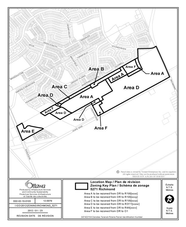
The proposed zoning amendment to reflect the draft approved plan of
subdivision is detailed in Document 2 and illustrated in Document 3. Specifically,
the proposed zoning by-law amendment would create the following zones:
1) Area A - The blocks identified for
single family dwelling lots would be rezoned to a Residential First Density
Subzone W (R1[XXXX]), permitting single dwellings only, with site-specific
provisions regarding lot size and setbacks.
2) Area B - The westerly block along
the northerly property line which abuts existing residential properties would
be rezoned to the above-noted Residential First Density Subzone W (R1W[XXXY]),
but with an exception specifying an increased rear yard setback requirement.
3) Area C - The easterly block along
the northerly property line which abuts existing residential properties would
be rezoned to the above-noted Residential First Density Subzone W (R1W[XXXZ]),
but with an exception specifying an increased rear yard setback requirement.
4) Area D - The majority of the
subdivision lands would be rezoned to Residential Third Density Subzone YY (R3YY
[XXXW]), permitting detached, townhouse or back-to-back townhouses, with site-specific
provisions regarding lot size and setbacks.
5) Area E - The separate parcel
abutting Eagleson Road would be rezoned to Residential Fourth Density Subzone A
R4A[XXXV], permitting a condominium development of townhouses or stacked units. The exception denotes that a holding symbol will apply to this
zone until such time as the final stormwater management solution for the
subdivision is approved.
6) Area F - The three parks will be
zoned Parks and Open Space Zone (O1).
Conclusion
The
proposed Zoning By-law amendment balances the need for intensification as
supported in the Official Plan with compatibility considerations. The proposed
zoning provisions will permit development of compact, more urban form of
housing that has been implemented in other new communities in the city by offering
an affordable product and wider range of housing types. It responds to
policies in the Official Plan that speak to the creation of unique, compact and
innovative developments that in the long term result in more efficient use of
the City infrastructure and resources.
The
Department supports the Zoning By-law amendment application and recommends that
it be approved.
RURAL IMPLICATIONS
N/A
CONSULTATION
Notice of this application was carried out in accordance with the City's Public Notification and Consultation Policy. The public comments and staff response are detailed in Document 4.
COMMENTS BY THE WARD COUNCILLOR
Councillor Allan Hubley is aware of the application and the staff recommendation.
LEGAL IMPLICATIONS
There are no legal implications associated with this report.
RISK MANAGEMENT IMPLICATIONS
There are no risk implications.
FINANCIAL IMPLICATIONS
There are no financial implications associated with this
report.
ACCESSIBILITY IMPACT
N/A
ENVIRONMENTAL IMPLICATIONS
The Rideau Valley Conservation Authority has indicated that there are no issues from an environmental point of view regarding the proposed Zoning By-law Amendment.
TECHNOLOGY IMPLICATIONS
CITY STRATEGIC PLAN
The proposed development aligns with the City Strategic Plan in that it respects the existing urban fabric, neighbourhood form, and the limits of existing infrastructure services, so that new growth is integrated seamlessly within an established community.
APPLICATION PROCESS TIMELINE STATUS
The application was processed by the "On Time Decision Date" established for the processing of Zoning By-law amendments. The application was “On Hold” for several months while the associated subdivision issues were resolved.
SUPPORTING DOCUMENTATION
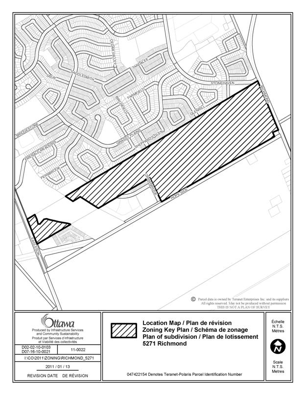
Document 1 Location Map
Document 2 Details of Recommended Zoning
Document 3 Zoning Schedule
Document 4 Consultation Details
DISPOSITION
City Clerk and Solicitor Department, Legislative Services to notify the owner, applicant, OttawaScene Canada Signs, 1565 Chatelain Avenue, Ottawa, ON K1Z 8B5, Ghislain Lamarche, Program Manager, Assessment, Financial Services Branch (Mail Code: 26-76) of City Council’s decision.
Planning and Growth Management to prepare the implementing by-law, forward to Legal Services and undertake the statutory notification.
Legal Services to forward the implementing by-law to City Council.
LOCATION MAP DOCUMENT 1
DETAILS OF RECOMMENDED ZONING DOCUMENT 2
1. Proposed changes to Zoning Bylaw 2008-250:
Rezone the subject lands shown in Document 1 as follows:
a. Area A from DR to R1W[XXXX]
b. Area B rezoned from DR to R1W[XXXY]
c. Area C from DR to R1W[XXXZ]
d. Area D from DR to R3YY[XXXW]
e. Area E from DR to R4A[XXXV]-h
f. Area F from DR to O1.
2. Add new exceptions, R1W[XXXX], R1W[XXXY], R1W[XXXZ], R3YY[XXXW], and R4A[XXXV]-h to Section 239 - Urban Exceptions with provisions similar in effect to the following:
For the R1W[XXXX] Exception:
· Minimum lot area is 220 m.²
· Minimum front yard setback is 3 m.
· Minimum front yard setback for an attached garage is 3.5 m.
· Minimum total interior side yard setback is 1.8 m with a minimum of 0.6 metres on at least one side. Where there is a corner lot on which is located only one interior side yard, the minimum required interior side yard setback equals the minimum required for at least one yard.
· Minimum corner side yard is 2.5 m.
· Maximum lot coverage is 55%.
·
A maximum of 60 per cent of the area of the front
yard, or the required minimum width of one parking space, whichever is the
greater, may be used for a driveway, and the remainder of the yard, except for
areas occupied by projections permitted under Section 65 and a walkway with a
maximum width of 1.8 metres, must be landscaped with soft landscaping.
·
Where
an attached garage accesses a public street by means of a driveway that crosses
a sidewalk, the attached garage must be setback at least 6 metres from the
nearest edge of the sidewalk.
·
Despite Table 65, Rows 1, 2 and 3, a chimney,
chimney box, fireplace box, eaves, eave-troughs, gutters and ornamental
elements such as sills, belts, cornices, parapets and pilasters may project 1
metres into a required interior side yard but no closer than 0.2 metres to the
lot line.
· Despite Table 65, Row 6(b), balconies and porches may project to within 0 metres of a corner lot line.
- Despite Table 65 Row 6(b), the steps of a porch may project 2.5 metres into a required yard, but may be no closer than 0.5 metres from a lot line other than a corner side lot line, from which they can be as close as 0 metres.
- Despite Table 65, Row 6(a), any portion of a deck with a walking surface higher than 0.3 metres but no higher than 0.6 metres above adjacent grade may project to within 0.6 metres of a lot line, and any portion of a deck with a walking surface less than 0.31 metres may project to within 0.3 metres of a lot line.
· Despite Table 65, Row 8, an air conditioning condenser unit may project 1 metres, but no closer than 0.2 metres to a lot line, and may not be located in a front yard except in the case of a back-to-back multiple dwelling, but may be located in a corner side yard.
· Despite Section 57(2), for multiple attached dwellings, the corner sight triangle will be calculated using 57(1) and in the instance of any dwelling listed in (1) including multiples, the distance used to determine a corner sight triangle is 2.75 metres and not 6 metres.
For the R1W[XXXY] Exception:
In column V the following:
· All of the provisions applicable to the R1W[XXXX] zone; and
· Minimum rear yard setback is 7.5 m.
For the R1W[XXXZ] Exception:
In column V the following:
· All of the provisions applicable to the R1W[XXXX] zone; and
· Minimum rear yard setback is 7.0 m.
For the R3YY[XXXW] Exception:
In column V the following:
·
A maximum of 60 per cent of the area of the
front yard, or the required minimum width of one parking space, whichever is
the greater, may be used for a driveway, and the remainder of the yard, except
for areas occupied by projections permitted under Section 65 and a walkway with
a maximum width of 1.8 metres, must be landscaped with soft landscaping.
·
Where
an attached garage accesses a public street by means of a driveway that crosses
a sidewalk, the attached garage must be setback at least 6 metres from the
nearest edge of the sidewalk.
·
Despite Table 65, Rows 1, 2 and 3, a chimney,
chimney box, fireplace box, eaves, eave-troughs, gutters and ornamental
elements such as sills, belts, cornices, parapets and pilasters may project 1
metres into a required interior side yard but no closer than 0.2 metres to the
lot line.
· Despite Table 65, Row 6(b), balconies and porches may project to within 0 metres of a corner lot line.
- Despite Table 65 Row 6(b), the steps of a porch may project 2.5 metres in to a required yard, but may be no closer than 0.5 metres from a lot line other than a corner side lot line, from which they can be as close as 0 metres.
- Despite Table 65, Row 6(a), any portion of a deck with a walking surface higher than 0.3 metres but no higher than 0.6 metres above adjacent grade may project to within 0.6 metres of a lot line, and any portion of a deck with a walking surface less than 0.31 metres may project to within 0.3 metres of a lot line.
· Despite Table 65, Row 8, an air conditioning condenser unit may project 1 metres, but no closer than 0.2 metres to a lot line, and may not be located in a front yard except in the case of a back-to-back multiple dwelling, but may be located in a corner side yard.
· Despite Section 57(2), for multiple attached dwellings, the corner sight triangle will be calculated using 57(1) and in the instance of any dwelling listed in (1) including multiples, the distance used to determine a corner sight triangle is 2.75 metres and not 6 metres.
· In the case of a home based business operating within a multiple attached or semi-detached dwelling, a parking space is only required if a non-resident employee works on-site.
· Section 136 does not apply.
Zone requirements for detached dwellings:
· Minimum lot area is 220 m.²
· Minimum front yard setback is 3 m.
· Minimum front yard setback for an attached garage is 3.5 m.
· Minimum total interior side yard setback is 1.8 metres with a minimum of 0.6 metres on at least one side. Where there is a corner lot on which is located only one interior side yard, the minimum required interior side yard setback equals the minimum required for at least one yard.
· Minimum corner side yard is 2.5 m.
· Maximum lot coverage is 55%.
Zone
requirements for semi-detached and multiple attached dwellings:
· Minimum lot area is 137 m.²
· Minimum lot width is 5.5 m.
· Minimum front yard setback is 3.0 m.
· Minimum interior side yard setback is 1.5 m.
· Minimum corner side yard is 2.5 m.
·
Maximum
building height is 14 m.
· Maximum lot coverage is 65%.
Zone requirements for back-to-back multiple
attached dwellings:
· Minimum lot area is 81 m.²
· Minimum lot width is 5.5 m.
· Minimum front yard setback is 3.0 m.
· Minimum rear yard setback is 0.0 m.
· Minimum interior side yard setback is 1.5 m.
· Minimum corner side yard is 2.5 m.
· Maximum building height is 14 m.
For the R4A[XXXV]-h Exception:
In column IV the text “all uses until such time as the holding symbol is removed.”
In column V the following:
·
The holding symbol can only be removed at such
time as it is shown to the satisfaction of the General Manager of Planning and
Growth Management that the final stormwater
solution for the subdivision has been identified and approved, and it has been
determined if stormwater management ponds are to be located within the area
affected by the Holding Zone.
ZONING SCHEDULE DOCUMENT
3
CONSULTATION DETAILS DOCUMENT 4
NOTIFICATION AND CONSULTATION PROCESS
Notification
and public consultation was undertaken in accordance with the Public
Notification and Public Consultation Policy approved by City Council for Zoning
By-law amendments. The statutory
public meeting for the associated Plan of Subdivision application was held in
the community on March 28, 2011, and was attended by approximately 120
residents. As a result of the public notification and
consultation process, concerns were raised by neighbouring residents, primarily
pertaining to traffic issues and type of proposed development. The concerns
related to zoning are summarized below.
SUMMARY OF PUBLIC INPUT
Public Comments
1. The proposed density
appears to be higher than that of the adjacent area, and lots appear to be quite shallow in depth. It
is unclear whether homes get a backyard of a reasonable size. The density should reflect the adjacent areas
to maintain the quality and character of the urban fabric.
2. The plan indicates
that both the singles and townhouse lots are to be smaller than those of the
adjacent properties, changing the character of the neighbourhood. This is not reflective of Bridlewood’s
existing community and built form.
3. The zoning requested
would rezone the entire area to a classification that permits townhouses
everywhere. This is worrying, because local residents don’t know what would be
built behind the existing single houses on Apple Creek Crescent or Wheatland
Avenue. Only single houses should be allowed on blocks that back onto existing
singles.
4. Smaller lot sizes suggest that townhouse units may be three-storey rather
than two-storey units, so new homes on the northern boundary of the site would
be close to, and tower over, adjacent existing homes. Along the northern
boundary, the proposed development should reflect the form of existing
townhomes.
5. The distribution of singles and townhouses should be established,
rather than just showing blocks that will be divided up later. It is understood
that the blocks behind existing homes will be lots for singles, but there is nothing
to prevent the developer from deciding to turn these blocks, or most of the development,
into townhouse lots, if the zoning allows it.
6. This development will introduce increased noise levels, view
restrictions, affect light availability or introduce shadowing to yards of existing
homes that back onto the land. This
would impact quality of life of people in the existing neighbourhood.
7. The edges of the
development along Hope Side Road and Richmond Road may be suited to stacked
homes, but the remainder of the plan should not be compromised. Higher density uses
should be provided along outer edges of
the community only, not near existing homes.
Response: The associated
draft plan of subdivision is comprised of blocks to be developed with a mix of
detached dwellings and freehold townhouse dwellings. In response to concerns
from neighbouring residents, certain portions of the site will be zoned to
permit only detached dwellings. The proposed zoning provisions therefore ensure
that only detached dwellings will be constructed in the northern portion of the
subdivision, on those blocks abutting all existing homes. This restriction
applies not only to blocks backing onto Wheatland Avenue, Apple Creek Crescent and
Glenrill Avenue, where detached homes are located, but also to blocks backing
onto Sheppard’s Glen Avenue and Flower Tree Crescent, which are occupied by
townhouses. This promotes compatibility with adjacent homes, and mitigates any
negative impact.
The largest portion of the site will be
occupied by a mix of housing types, with larger groupings of townhouse
dwellings being located primarily in the southerly half of the site. The block
adjacent to Eagleson Road has been identified for condominium development,
being in proximity to the existing condominium development. This ensures that
compatibility with the existing type of development will be maintained.
The subdivision layout proposes a reduced lot depth as one of the components in making efficient use of land and allowing for a more urban, compact type of development that has been constructed in many other parts of the City. The proposed plan complies with the urban design and development guidelines of the Official Plan, providing a modern form of development that is compatible with the existing community.
Community Organization Comments
The following are the comments and concerns of the Bridlewood Community
Association regarding the initial submission of the subject application:
1. The re-zoning
application seeks to rezone the entire area as R3YY which will permit detached
homes or townhouses to be built anywhere.
This ambiguity is unacceptable, as the resulting density could vary
greatly. Therefore, the BCA requests
that all townhouse blocks be specifically identified for zoning purposes and
all remaining lands be specifically identified for the purposes intended, such
as detached residential, school and park use.
Response: The Zoning By-law amendment will
specifically delineate areas where only detached dwellings are permitted, in
order to control unit type distribution. The park blocks will also be
specifically zoned for such use.