|
6. ZONING - 200 LOCKHART AVENUE ZONAGE -
200, AVENUE LOCKHART |
Committee
recommendation
That Council
approve an amendment to the Zoning
By-law 2008-250 to change the zoning of 200 Lockhart Avenue from Community
Leisure Facility Zone (L1) to Residential Fifth Density Subzone P exception
zone with a height limit of 26 metres,
R5P [XXXX] H(26m) as shown in Document 1 and detailed in Document 2.
Recommandation DU Comité
Que le Conseil approuve
une modification au Règlement de zonage 2008-250 visant à faire passer
la désignation de zonage de la propriété située au 200, avenue Lockhart, de
Zone d’installation de loisirs communautaire (L1) à Zone résidentielle de
densité 5, sous-zone P, zone d’exception, avec une hauteur limite de 26 mètres (R5P [XXXX] H(26m)), comme l’illustre le document 1 et le
précise le document 2.
Documentation
1.
Deputy City
Manager's report, Planning and Infrastructure, dated 3 March 2012 (ACS2012-PAI-PGM-0077).
Report to/Rapport au:
Comité de l'urbanisme
et de l'environnement
03 March 2012 / le 3 mars 2012
Submitted by/Soumis par : Nancy Schepers, Deputy City
Manager/Directrice municipale adjointe, Planning and
Infrastructure / Urbanisme et Infrastructure
Contact Person/Personne-ressource : John
Smit, Manager/Gestionnaire, Development Review Urban Services/Examen des
projets d'aménagement-Services urbains, Planning and Growth
Management/Urbanisme et Gestion de la croissance
(613) 580-2424, 13866 John.Smit@ottawa.ca
|
SUBJECT: |
|
|
|
|
|
OBJET : |
REPORT RECOMMENDATION
That the Planning and Environment Committee recommend Council approve
an amendment to the Zoning By-law 2008-250 to change the zoning of 200 Lockhart
Avenue from Community Leisure Facility Zone (L1) to Residential Fifth Density
Subzone P exception zone with a height limit of 26 metres, R5P [XXXX] H(26m) as shown in Document 1 and detailed in
Document 2.
RECOMMANDATION DU RAPPORT
Que le Comité de
l’urbanisme et de la gestion de la croissance recommande au Conseil d’approuver
une modification au Règlement de zonage 2008-250 visant à faire passer la
désignation de zonage de la propriété située au 200, avenue Lockhart, de Zone
d’installation de loisirs communautaire (L1) à Zone résidentielle de densité 5,
sous-zone P, zone d’exception, avec une hauteur limite de 26 mètres (R5P [XXXX] H(26m)), comme l’illustre le document 1 et le
précise le document 2.
BACKGROUND
The subject site is located at
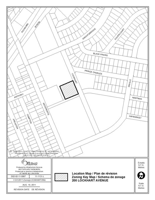
The property is square in shape and has an area of 3677 square metres, with a 60.9 metre frontage along Lockhart Avenue. It is currently occupied by a fitness facility (YMCA) and an associated parking lot.
This neighbourhood was developed
during the 1950s and 1960s and is comprised of a broad mixture of land uses. Immediately north of the site along the
western side of
Purpose of Zoning Amendment
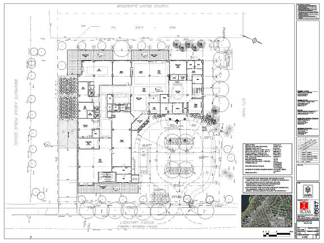
The purpose of this Zoning By-law amendment is to facilitate the construction of an eight-storey retirement and residential care facility. The development will be comprised of approximately 105 independent living units and approximately 54 assisted living units for a total of approximately 159 units.
Existing Zoning
The site is currently
zoned “Community Leisure Facility Zone” (L1), which permits recreational uses
that meet the needs of the surrounding community. The following uses are permitted in
the L1 zone: community centre, community garden, day care, emergency service, library,
municipal service centre, park, recreational and athletic facility and sports
arena.
Proposed Zoning
The requested by-law amendment proposes to rezone the site at 200 Lockhart Avenue from Community Leisure Facility Zone (L1) to Residential Fifth Density Subzone P exception zone with a height limit of 26 metres (R5P [XXXX] H(26)) in order to construct an eight-storey (24.5‑metre) retirement and residential care facility with a total of 159 units. The zoning would also allow for a 0-metre southern interior side yard for a portion of the building to accommodate the ramp into the underground garage.
DISCUSSION
Provincial Policy Statement
The Provincial Policy Statement (PPS) provides
direction on matters of provincial interest related to land use planning and
development. The Planning Act
requires that decisions affecting planning matters “shall be consistent with”
such policy statements issued under the Act.
The PPS policies speak to an appropriate mix of uses to support strong, liveable, and healthy communities, and densities that efficiently use land and support alternative transport modes.
The proposal meets the intent of the PPS by providing a new and
appropriate housing type, a retirement and residential care facility, in the
area to meet the needs of current and future residents. The development is serviced by appropriate municipal
infrastructure (water, sewer, roads, and transit) and other amenities (park,
commercial development, places of worship).
The PPS encourages intensification of sites in order to make use of
existing services, which also minimizes the cost of housing and facilitates
compact form while creating strong, liveable and healthy communities.
The site is located on a local road, close to an arterial road which forms the boundary of the neighbourhood and allows for reasonable access by pedestrians and transit.
Staff concludes that the proposal is consistent with the matters of provincial interest as outlined in the PPS.
Official Plan
Land Use Designation:
The
subject property is designated as “General Urban Area” in the Official Plan. “This designation permits the development of a full
range and choice of housing types to meet the needs of all ages, incomes and
life circumstances.”
The Official Plan supports infill development and other intensification
that enhances and complements the desirable characteristics and ensures the
long-term vitality of existing communities.”
The proposal to provide new and modern retirement units and residential
care units contributes to the overall housing choice available to residents in
the area. As residents age, many wish to
stay in the same residential neighbourhood where they have lived for many
years. The development, facilitated by
the re-zoning, will permit that option, in keeping with the intent of the
Official Plan policies for the General Urban Area.
2.5.1 Compatibility and Urban Design:
Section 2.5.1 outlines strategic directions to deal
with growth in Ottawa and how best to build liveable communities. Compatibility Policies consider how well a
new building fits into an existing built up community. Urban design takes into account how well a
proposal deals with the streetscape on a human scale and considers whether buildings,
landscapes and public space function well together. New developments do not need to replicate the
existing buildings, but should ‘fit in’ with the existing physical context and
enhance an established community and coexist – without causing undue negative
impacts on adjacent properties.
Section 2.5.1 also sets out broad design objectives as qualitative
statements on how the City will influence the built environment as the city
evolves. These objectives are focused on enhancing the sense of community
and maintaining places with their own distinct identity, providing quality
public and private spaces through development, creating places that are safe,
accessible and easy to get to and move through, ensuring that new development
respects the character of existing areas, and creating places that can adapt
easily and evolve over time. Design principles further describe how each of the
design objectives may be achieved.
The proposed eight-storey building has been adequately
designed with an outdoor patio and restaurant area located at the front of the
building, which will animate the street. The site layout has also been designed with
only one sidewalk cut for the circular driveway at the front of the building –
which provides for a safe pedestrian environment. A
portion of the building has been recessed from the street in order to provide a
circular driveway for the ease of residents’ access to the building entrance.
4.11 Urban Design and Compatibility:
The proposed development, facilitated by the re-zoning, has been
reviewed based on the Official Plan criteria for compatibility – namely – building
height and massing, pattern of surrounding community, traffic, vehicular
access, parking, outdoor amenity area, loading areas, service areas and outdoor
storage, lighting, noise and air quality, sunlight, microclimate and supporting
neighbourhood services. The following key considerations have been
applied to the proposed rezoning to ensure the intent of Section 4.11 has been
met.
a) Building Height and Massing/Pattern of Surrounding Community:
The development should be “massed to fit
harmoniously for the area…” In this
case, the existing built context surrounding the subject site is one of low
profile institutional facilities (schools and churches) and three mid-rise
apartment buildings. There are also some
single detached dwellings in proximity to the subject property. The construction of an eight-storey
residential building fits well within the built context of the area and should not
unduly affect the existing residents nor will it change the general character
of the neighbourhood.
b) Vehicular Access:
The location of vehicular access should address nuisances such as noise, headlight glare and loss of privacy on adjacent properties. The proposed use is not expected to be a high traffic generator and it is therefore an appropriate use for this local street. The site is bounded to the north by a municipal park and to the south by an undersized and un-travelled Municipal road allowance –and as such, there should be no nuisance to these properties due to vehicles accessing the subject site.
c) Loading Areas, Service Areas and Outdoor Storage:
The operational characteristics and visual appearance of loading, service areas and outdoor storage should be mitigated. The preferred site design places loading and refuse collection area near the front of the building, however they are screened by the building from the property to the south and through the site plan control process, the facilities will be well designed so as to not be visually obtrusive from the street or from adjacent properties. There is no proposed outdoor storage.
d) Sunlight:
Developments should minimize shadowing on
adjacent properties. Shadow studies have
been prepared for the proposed development and show that there is very little
shadow impact on adjacent properties. Specifically
in the summer months – there is no projected shadow over the adjacent wading
pool and park, nor over the rear yards of the residents to the rear of the
subject site.
City staff has determined that the development meets the compatibility
criteria.
Details of Proposed Zoning
The proposed zoning for the site
is Residential Fifth Density Subzone P, Exception [XXXX] with a height limit (R5P
[XXXX] H(26)) to permit a 24.5-metre retirement home/residential care facility
as detailed in Document 2. The zone will
also permit the reduction of the southerly interior side yard to 0-metres for approximately
20.0 metres for the portion of the building that houses the ramp to the
underground garage.
Conclusion
The proposed development balances the need for intensification and infill as supported in the Official Plan, while also addressing compatibility considerations. The proposed Zoning By-law Amendment conforms to the general intent of the Official Plan and staff recommends approval of the proposed zoning. The Site Plan Control (see Document 4) will be further reviewed and approved at such time as the proposed Zoning By-law Amendment is in full force and effect.
RURAL IMPLICATIONS
There are no rural implications associated with this report.
CONSULTATION
Notice of this application was carried out in accordance with the City's Public Notification and Consultation Policy. The City received five negative comments on this application. A summary of public comments and the staff response is included in Document 3.
COMMENTS BY THE WARD COUNCILLOR
Councillor Mark
Taylor, Bay Ward, is aware of, and supports the application.
LEGAL IMPLICATIONS
Should the zoning be appealed to the Ontario Municipal Board, it is anticipated that a three day hearing would result. If the zoning is refused by Council, reasons must be provided. In the instance of a refusal an external planning consultant would need to be retained by the City at an estimated cost of $30,000.
RISK MANAGEMENT IMPLICATIONS
There are no risk implications associated with this report.
FINANCIAL IMPLICATIONS
ACCESSIBILITY IMPACT
There are no accessibility issues associated with this zoning application.
ENVIRONMENTAL IMPLICATIONS
The Rideau Valley Conservation Authority and City staff have indicated that there are no issues from an environmental point of view regarding the proposed Zoning By-law Amendment.
TECHNOLOGY IMPLICATIONS
There are no direct technical implications associated with this report.
CITY STRATEGIC PLAN
The proposed development and planning applications align with the City Strategic Plan in that it respects the existing urban fabric, neighbourhood form, and the limits of existing hard services, so that new growth is integrated seamlessly with established communities.
APPLICATION PROCESS TIMELINE STATUS
The Zoning By-law amendment application was not processed by the "On Time Decision Date" established for the processing of this type of application, due to the time required to resolve site design issues.
SUPPORTING DOCUMENTATION
Document 1 Location Map
Document 2 Details of Recommended Zoning
Document 3 Consultation Details
Document 4 Site Plan
DISPOSITION
City Clerk and Solicitor Department, Legislative Services to notify the owner, applicant, OttawaScene.com, 174 Colonnade Road, Unit #33, Ottawa, ON K2E 7J5, Ghislain Lamarche, Program Manager, Assessment, Financial Services Branch (Mail Code: 26-76) of City Council’s decision.
Planning and Growth Management to prepare the implementing by-law, forward to Legal Services and undertake the statutory notification.
Legal Services to forward the implementing by-law to City Council.
LOCATION MAP DOCUMENT 1
DETAILS OF RECOMMENDED ZONING DOCUMENT 2
Proposed Changes to the Comprehensive Zoning By-law
1. Rezone the lands shown in Document 1 from L1 to R5P[XXXX] H(26)
2. Add a new exception, R5P[XXXX] H(26), to Section 239 with provisions similar in effect to the following:
a) In Column II the text “R5P[XXXX] H(26)”;
b) In Column V the text “ – minimum interior side yard setback from the southern side lot line for any part of a building no greater than 3.0 metres in height and located between 25.0 metres and 50.0 metres back from the front lot line: 0 m”
CONSULTATION DETAILS DOCUMENT
3
NOTIFICATION AND CONSULTATION PROCESS
Notification
and public consultation was undertaken in accordance with the Public
Notification and Public Consultation Policy approved by City Council for Zoning
By-law amendments.
PUBLIC COMMENTS
SUMMARY OF PUBLIC INPUT
There were several comments received from the public. The concerns and staff responses are summarized as follows:
1. Loss of Community Space: Several residents were upset that a community recreational facility was being lost from the neighbourhood and their ‘rights’ were being taken away. Suggestions were made that perhaps an updated YMCA or combined municipal building with library and other municipal facilities would have been a more appropriate use for the site.
Response: The YMCA is a private company who chose to
privately sell their land. The City of
2. Loss of neighbourhood attractiveness, loss of views, loss of values: Several residents were concerned that the neighbourhood would not be as attractive due to the construction of an 8-storey building and that property values would decrease. One resident was concerned about the impact on the view of the trees from their rear yard, with the eight-storey building rising up behind the trees.
Response: The City does not believe that the neighbourhood will be less attractive with the addition of an eight-storey residential building. The Planning Act does not govern the protection of views. The related development proposal will be well designed with plantings of trees and shrubs and is not considered ‘unattractive’. There is no evidence of any impact on property values.
3. Construction Disruption: One resident was concerned about the disruption to residents’ lives in terms of noise, traffic and emissions during the construction process.
Response: City Inspectors and By-law Enforcement Officers enforce the Ontario Building Code as well as Noise and Traffic complaints to ensure that all rules are applied. Emissions from construction machinery are not governed by municipal governments, but rather by Federal officials. Construction fencing and access routes will be handled during the Site Plan Control process.
4. Sunlight: Several residents were concerned about the shadow impact on adjacent properties – specifically on the park and rear yards to the west of the subject site.
Response: A sun shadow study was prepared and there is no discernable negative impact on the adjacent park nor to the residents to the west.
5. Precedent: Several residents were concerned that the approval of this rezoning will set a precedent for future rezoning.
Response: Each re-zoning application is reviewed under the Official Plan and other policies on its own merit based on the proposal and location while taking compatibility issues into consideration.
6. Compatibility: Several residents were concerned that the proposal will not fit into the community, because an eight-storey building is higher than other developments in the area.
Response: The eight-storey
building is only slightly taller than the three existing seven-storey apartment
buildings at the corner of
The related development is considered to be in keeping with the intent of the compatibility policies of the Official Plan.
DRAFT SITE PLAN DOCUMENT
4