|
7. ZONING – 145 CLARIDGE DRIVE ZONAGE –
145, PROMENADE CLARIDGE |
Committee
recommendation
That Council
approve an amendment to the Zoning By-law 2008-250 to change the zoning of 145
Claridge Drive from Minor Institutional Zone (I1A) to Residential Third Density
Zone, Subzone YY with an Exception (R3YY[XXXX]H(12)) as shown in Document 1 and
detailed in Document 2.
Recommandation DU Comité
Que le Conseil approuve
une modification du Règlement de
zonage 2008-250 qui ferait passer le zonage au 145 de la promenade Claridge de
« zone de petites institutions » (I1A) à « zone résidentielle de
densité 3, sous-zone YY, avec exception » (R3YY[XXXX]H(12)), tel que le
montre le document 1 et que le fait voir en détail le document 2.
Documentation
1.
Deputy City
Manager's report, Planning and Infrastructure, dated 16 March 2012 (ACS2012-PAI-PGM-0054).
Report to/Rapport au :
Comité de l'urbanisme
and Council / et au Conseil
16 March 2012 / le 16 mars 2012
Submitted by/Soumis par : Nancy Schepers, Deputy City Manager/Directrice
municipale adjointe, Planning and Infrastructure /
Urbanisme et Infrastructure
Contact
Person/Personne-ressource : Derrick Moodie, Acting Manager/Gestionnaire
intérimaire, Development Review-Suburban Services/Examen des projets
d'aménagement-Services suburbains, Planning and Growth Management/Urbanisme et
Gestion de la croissance
(613)
580-2424, 15134 Derrick.Moodie@ottawa.ca
|
SUBJECT: |
|
|
|
|
|
OBJET : |
REPORT RECOMMENDATION
That the Planning Committee recommend
Council approve an amendment to the Zoning By-law 2008-250 to change the zoning
of 145 Claridge Drive from Minor Institutional Zone (I1A) to Residential Third
Density Zone, Subzone YY with an Exception (R3YY[XXXX]H(12)) as shown in
Document 1 and detailed in Document 2.
RECOMMANDATION
DU RAPPORT
Que le Comité de l'urbanisme recommande au
Conseil d'adopter une modification du Règlement de zonage 2008-250 qui ferait
passer le zonage au 145 de la promenade Claridge de « zone de petites
institutions » (I1A) à « zone résidentielle de densité 3, sous-zone
YY, avec exception » (R3YY[XXXX]H(12)), tel que le montre le document 1 et
que le fait voir en détail le document 2.
BACKGROUND
Purpose of Zoning Amendment
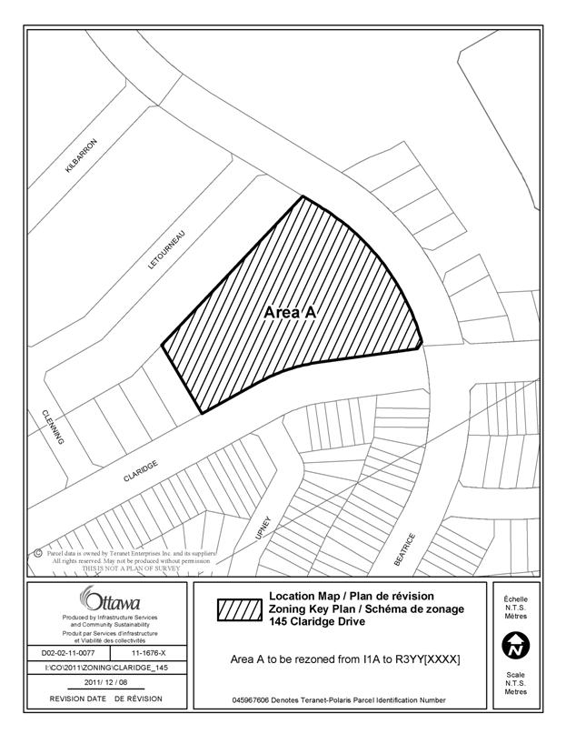
The property subject to this Zoning By-law amendment is 145 Claridge Drive. The parcel of land is within the City’s Longfields Subdivision located within the South Nepean Community of Barrhaven. The 1.2 hectare property is currently vacant and is located on the north side of Claridge Drive at the intersection of Beatrice Drive and Claridge Drive. The adjacent lands to the north are owned by the Nepean Housing Corporation and include existing townhouses. The lands west and east of the subject property are currently being constructed with single and semi detached dwellings. Existing townhouses are located on the south side of Claridge Drive. The subject property is shown in Document 1.
The Longfields Draft Plan of Subdivision was draft approved in September 2008 to accommodate a variety of residential densities and units as well as some limited institutional and commercial land uses. At that time, the subject property was rezoned (as per Bylaw 2008-290) to permit an institutional use.
The subject property subsequently has been registered through Phase 1 of the Longfields Plan of Subdivision as Block 56 on registered Plan 4M-1427. The Ottawa Land Development Corporation has marketed this parcel for institutional use without a successful purchaser and would like to rezone the property to permit residential development that would be compatible with the surrounding land uses. In order to achieve this type of development an amendment is required to the Zoning By-law to permit different or additional uses and zoning standards.
Existing Zoning
The subject property is currently zoned Minor Institutional Zone, Subzone A (I1A) which permits a range of communities uses, institutional accommodation and emergency services uses located in areas designated as General Urban Area in the Official Plan.
Proposed Zoning
The proposed zoning as shown in Document 2 is to amend the existing Minor Institutional Zone to Residential Third Density Zone, Subzone YY with an Exception (R3YY[XXXX]H(12)). The Residential Third Density Zone would permit residential development on the subject property. A site specific exception has been requested to permit stacked dwellings as an additional permitted use with a maximum building height of 12 metres.
DISCUSSION
Official Plan
Land Use Designation
The
subject property is designated General Urban Area in the Official Plan. The General Urban Area designation permits
the development of a full range and choice of housing types to meet the needs
of all ages, incomes and life circumstances.
The Official Plan supports infill and intensification within the General
Urban Area where it enhances and complements existing areas and contributes to
their long term vitality. The Plan
directs growth to established areas in order to maximize the use of land that
is already serviced, accessible and close to existing amenities. In addition to the General Urban Area
policies, development applications require consideration of Section 2.5.1 and
Section 4.11 Urban Design and Compatibility.
The proposed amendment fulfills the Official Plan intent to promote intensification due to the subject property’s location within an existing and planned residential community. The additional permitted stacked townhouse units fulfil the housing objectives through the inclusion of multiple types of housing for a variety of demographic profiles throughout the General Urban Area.
The proposed amendment is consistent with the compatibility and design policies as the residential zone provides for a range of housing types that are ground-oriented producing moderate densities and form similar to and compatible with other housing types permitted in the areas adjacent to the site.
Any future proposed site plan for the subject property will be evaluated against the compatibility criteria in Section 4.11 of the Official Plan as well as against the additional design standards set out in the South Nepean Secondary Plan for Areas 1, 2 and 3.
South Nepean Secondary Plan
The
subject property is designated Mixed Density Residential within the South
Nepean Secondary Plan Areas 1, 2 and 3. The Mixed Density
Residential designation permits a range of dwelling types including single detached, street and stacked
townhouses as well as low rise apartments. The Mixed
Density Residential designation has a minimum density of 25 units per
hectare. Higher density housing forms
are encouraged in locations near to the rapid-transit network, arterial and
collector road and community facilities such as schools and parks. Building heights are limited to four-storeys
and to decrease the dominance of residential garages along the street, garages
are to be located at the rear or side of dwelling units or even with the front
façade of the residential unit.
The subject property is located at the intersection of two collector
roads, Beatrice Drive and Claridge Drive.
Beatrice Drive, Claridge Drive and Longfields Drives are all designated
as “Community Cycling Routes”, which are designed to connect neighbourhoods to
city-wide routes and local neighbourhood amenities. The subject property is well-served by
transit with a two bus routes along Beatrice Drive providing service to the
nearby Fallowfield Transitway. The
property is in proximity to a number of existing schools and parks.
The proposed zoning amendment to permit stacked dwellings is consistent
with the provisions of the Secondary Plan as it allows for a broader range of
housing types and can produce the desired levels of density for a Mixed Density
Residential area.
Zoning By-law
The proposed zoning is to amend the existing Minor Institutional Zone to Residential Third Density Zone, Subzone YY with an Exception (R3YY[XXXX]H(12)) to permit stacked dwellings as an additional permitted use with a maximum building height of 12 metres. In addition, the following performance standards will be revised: Front Yard reduced to 3.5 metres Corner Side Yard reduced to 4 metres, Rear Yard reduced to 4m, and Interior Side Yard is 7.2 meters.
The Accessory Building size (max.) will be increased to 160m2, and the Corner Side Yard setback for the Accessory Building is proposed to be 3 metres.
The details of the proposed zoning are outlined in Document 2.
All other provisions of the R3YY subzone regarding building form massing, such as minimum lot width and area and building setbacks will remain the same.
The site is located in a residential area containing a mix of single, semi-detached dwellings and townhouses. While several adjacent properties are currently undeveloped, the area is part of the larger Longfields community and will be built out over the next few years. The proposed zoning from institutional to residential and permitting stacked dwelling units will increase the range of housing choices for a community that is experiencing a change in demographics.
The Department supports the Zoning By-law amendment application because
it is consistent with
policies in the Official Plan.
RURAL IMPLICATIONS
There are no rural implications associated with this report.
CONSULTATION
Notice of this application was carried out in accordance with the City's Public Notification and Consultation Policy. The details of the consultation can be seen in Document 3.
COMMENTS BY THE WARD COUNCILLOR
Councillor Harder is aware of this
application and the staff recommendation. She has no objections to the proposed
amendments.
LEGAL IMPLICATIONS
There are no legal implications associated
with the recommendations of this report.
RISK MANAGEMENT IMPLICATIONS
There are no risk
management implications associated with the recommendations of this report.
FINANCIAL IMPLICATIONS
There are no direct
financial implications.
ACCESSIBILITY IMPACT
ENVIRONMENTAL IMPLICATIONS
There are no environment implications associated with the recommendations of this report.
TECHNOLOGY IMPLICATIONS
There are no technological implications associated with the recommendations of this report.
CITY STRATEGIC PLAN
The Council Strategic Priorities provide direction to meet the challenge of managing growth, providing infrastructure, maintaining environmental integrity and creating liveable communities within Ottawa. To meet these challenges, priorities are set out to pursue a mix of land uses and compact forms of development. The proposed rezoning will support this overall goal and can move forward the following priorities and objectives:
Improve social and affordable housing - Provide affordable, attractive and accessible housing, and improve the range and quality of housing for people of diverse abilities and incomes to live in a community through various life stages.
APPLICATION PROCESS TIMELINE STATUS
The application was not processed by the "On Time Decision Date" established for the processing of Zoning By-law amendments as priority was given to the registration of phases within the Longfields Plan of Subdivision.
SUPPORTING DOCUMENTATION
Document 1 Location Map
Document 2 Details of Recommended Zoning
Document 3 Consultation Details
DISPOSITION
City Clerk and Solicitor Department, Legislative Services to notify the owner, applicant, OttawaScene Canada Signs, 1565 Chatelain Avenue, Ottawa, ON K1Z 8B5, Ghislain Lamarche, Program Manager, Assessment, Financial Services Branch (Mail Code: 26-76) of City Council’s decision.
Planning and Growth Management to prepare the implementing by-law, forward to Legal Services and undertake the statutory notification.
Legal Services to forward the implementing by-law to City Council.
LOCATION MAP DOCUMENT
1
DETAILS OF RECOMMENDED ZONING DOCUMENT 2
Proposed
Changes to the Comprehensive Zoning By-law
The subject land, being the property municipally known as 145 Claridge Drive and as shown on Document 1 is subject to the following text and zoning amendments:
1. The property as shown on Document 1 be rezoned from I1A to R3YY[XXXX]H(12) with a new exception that will be added to Section 239 – Urban Exception that will include the following provision in Column III and Colum V respectively:
- Stacked dwelling
- Maximum building height for a stacked dwelling: 12 metres
2. The following site specific exceptions are also proposed:
- Minimum Yard Front: 3.5m
- Minimum Corner Side Yard: 4.0m
- Minimum Rear Yard: 4.0m
- Minimum Interior Side Yard: 7.2m
- Accessory Building Size (maximum): 160 sq. m.
- Minimum Accessory Building Corner Side Yard: 3.0m
CONSULTATION DETAILS DOCUMENT 3
NOTIFICATION AND CONSULTATION PROCESS
Notification and public consultation was undertaken in accordance with the Public Notification and Public Consultation Policy approved by City Council for Zoning By-law amendments.
SUMMARY OF PUBLIC INPUT
Comment: Transportation
Two comments were received from the public outlining a concern for increased traffic as a result of the proposed rezoning.
Response:
A Transportation Impact Study was prepared for the Longfields Draft Plan of Subdivision and the findings of the study indicated that the arterial and collector roads in the area were operating at an acceptable Level-of-Service.