Report to/Rapport au :
Planning and Environment Committee
Comité de l'urbanisme et de
l’environnement
and Council / et au Conseil
18 November 2004 / le 18 novembre 2004
Submitted by/Soumis par : Ned Lathrop, Deputy City Manager/Directeur
municipal adjoint,
Planning
and Growth Management / Urbanisme et Gestion de la croissance
Contact Person/Personne
ressource : Richard Kilstrom, Manager/Gestionnaire, Community Planning and
Design Division/Conception communautaire
Planning, Environment and Infrastructure
Policy/Politique d'urbanisme, d'environnement et d'infrastructure
(613) 580-2424 x,22653,
richard.kilstrom@ottawa.ca
|
SUBJECT: |
GREELY COMMUNITY DESIGN PLAN -
Official Plan Amendment |
|
|
|
|
OBJET : |
PLAN DE CONCEPTION COMMUNAUTAIRE DE
GREELY - MODIFICATION DU PLAN OFFICIEL |
REPORT RECOMMENDATION
That Planning and Environment Committee
recommend that Council:
1. Approve
the Community Design Plan for the Village of Greely as detailed in Document 6
(separate cover).
2. Adopt
Official Plan Amendment No. X to the Official Plan (2003) of the City of
Ottawa, as detailed in Document 3, to remove the existing Greely Village Plan
and to add the new Greely Community Design Plan.
3. Adopt
Official Plan Amendment No. XX to the Official Plan of the former Township of
Osgoode, as detailed in Document 3, to remove the policies and schedule as they
relate to Village of Greely.
4. Direct Staff to bring forward at a later meeting of the Planning and Environment Committee a zoning by-law amendment, as detailed in Document 4, that implements in part the recommendations of the Greely Community Design Plan.
RECOMMANDATION DU RAPPORT
Que le Comité de l'urbanisme et de
l'environnement recommande au Conseil :
1. d'approuver
le Plan de conception communautaire pour le village de Greely, tel qu'exposé en
détail dans le Document 6 (sous pli séparé);
2. d'adopter
la modification no X au Plan officiel (2003) de la Ville d'Ottawa, telle
qu'exposée en détail dans le Document 3, afin d'y supprimer le Plan actuel du
village de Greely et d'y ajouter le nouveau Plan de conception communautaire de
Greely;
3. d'adopter
la modification no XX au Plan officiel de l'ancien canton d'Osgoode, telle
qu'exposée en détail dans le Document 3, afin d'y supprimer les politiques et
l'annexe se rapportant au village de Greely;
4. de
demander au personnel de présenter, à l'occasion d'une réunion ultérieure du
Comité de l'urbanisme et de l'environnement, une modification au règlement
municipal de zonage, telle qu'exposée en détail dans le Document 4, en vue de
mettre en œuvre en partie les recommandations du Plan de conception
communautaire de Greely.
BACKGROUND
Located in the former Township of Osgoode, Greely is
the largest rural village in Ottawa in terms of land area with approximately
1,050 hectares of land within its boundaries and the third largest in terms of
population with approximately 4,150 people (Document 1). Historically Greely was two separate
villages from a planning perspective: Greely, centered along Parkway Road west
of Highway 31, and Greely West, centered along Parkway Road and Stagecoach
Road. Several boundary expansions
throughout the 1980s and 1990s combined the two villages by adding the lands
in-between and surrounding the villages.
Presently approximately 55% of the land with Greely's boundaries is
developed, the vast majority of which is for single detached dwellings.
Greely has been the fastest growing rural
village in Ottawa over the last thirty years, attributable primarily to its
proximity to the City's urban areas combined with the draw of its rural
atmosphere. Based on the supply of land
designated Residential and current development trends, approximately 1,900 new
dwelling units could potentially be constructed in Greely. This represents a potential doubling of the
current total number of dwelling units in Greely.
A host of planning issues make Greely atypical
of other rural villages in Ottawa.
These issues include the Greely's boundary evolution and the large areas
of vacant land within the centre of the village; the absence of a "main
street" containing a concentration of commercial and service uses; the
presence of several rural estate developments adjacent to the village's
boundary; the presence of an industrial park in the centre of the village; and
residents identifying more with individual subdivisions than the community as a
whole.
The Planning and Growth Management Department
initiated the Greely Land Use and Design Study (Greely LUDS) in February 2003
to address these issues by developing a comprehensive land use vision and
plan. FoTenn Consultants Inc. was
retained by the City to undertake the Greely LUDS, the process and timeline of
which is detailed in Document 2. The
Study's final report in May 2004 included four main components: key principles
for future growth and development; a village land use plan and land use
policies; village core design recommendations; and suggested tools for
implementation.
The Council-adopted Official Plan states that City Council will approve community design plans as land use policy plans to replace the existing village plans in Volume 2C of the Official Plan. The Planning and Growth Management Department prepared a Greely Community Design Plan (Greely CDP) based on the recommendations of the Greely LUDS. The proposed Official Plan Amendments would remove the policies and schedules in the Council-adopted Official Plan and Official Plan of the former Township of Osgoode as they relate to Greely and would add the Greely Community Design Plan to the Council-adopted Official Plan.
DISCUSSION
The Planning and Growth Management Department prepared
the Greely CDP based on the recommendations of the Greely LUDS' final report.
These recommendations were revised and enhanced where necessary to fit them
into the policy framework of a Community Design Plan and to account for new
information that became available after completion of the final report. The Greely CDP, distributed under separate
cover, is comprised of the following seven components:
(1)
Community Vision
This section highlights the public consultation process of the Greely
LUDS and discusses the vision statement developed by participants at the
visioning workshop. Five key principles
were developed from the vision statement and the directions of the Official Plan and were the foundation
when developing the recommended land use plan. The five development principles
are:
Principle 1: Open Space and Recreation - develop a greenspace system that integrates all recreational and environmental areas of the Village.
Principle 2: Linkages - provide an interconnected system of walkways, trails and roads to connect different areas of the Village.
Principle 3: Sustainability - ensure that all future development does not adversely impact the Village's water resources.
Principle 4: Diversity and Community Character - provide a range of housing types and commercial opportunities while maintaining the rural atmosphere.
Principle 5: Mobility - provide an interconnected transportation system maintaining and enhancing accessibility.
(2)
Growth Management Strategy
This section identifies how all future growth
and development in Greely will be accommodated in order to promote the
sustainable development of the Village. This section is comprised of three
subsections:
Village Boundary:
Describes how Greely's village
boundary will be evaluated in the future and how development applications
adjacent to the boundary will be reviewed.
Environmental
Protection:
Describes the subwatershed study,
the drainage study and the hydrogeological characterization study undertaken
concurrently with the Greely LUDS. The
Greely CDP incorporates these studies' recommendations wherever possible.
Servicing:
Identifies that all future
development in Greely will be serviced by individual private water supply and
sanitary sewer systems, with the exception of subdivisions with previous
approvals for communal systems.
(3)
Land Use Plan
This section describes the land use plan that
will guide Greely's future development.
There are nine land use designations within the Greely CDP, five of
which are existing designations with the majority of existing policies intact
and four of which are new designations
which reflect the recommendations of the Subwatershed Study or the direction of the Official Plan. The designations are:
1. Residential
2. Village
Core
3. Shopping
Centre Commercial
4. Highway
Commercial
5. Industrial
6. Open
Space
7. Provincially
Significant Wetland
8. Ecological
Feature
9. Ecolological
Function
(4)
Village Core Plan
This section provides design guidelines that
promote the development of a unique identity
for Greely's Village Core. The design
guidelines are meant to be a guide to development within Greely's Core during
the development review process and are divided into four themes.
Built
Form Guidelines:
Promote a built form that promotes a
variety of uses and variety of forms in the Core, gives the Core a distinct
identity, and that works well with the streetscape.
Streetscape
Guidelines:
Promote streetscapes in the Core
that are safe and allow ease of movement for pedestrians, are linked to
surrounding neighbourhoods, and creates
an intimate and visually appealing public atmosphere.
Gateway
and Edge Guidelines:
Promote key gateway and edges in
the Core that are visually appealing and provide a positive image of Greely.
Key
Development Site Guidelines:
Provide further, site-specific
direction to three presently vacant sites within the Core that offer an
excellent opportunity for showcasing the guidelines.
(5)
Road Network
This section describes Greely's road network,
which is intended to accommodate all transportation types while keeping safety
and accessibility in mind. The road
network plan shows all existing arterial, collector and local roads together
with the conceptual future collector, conceptual future local road patterns,
and future road connections to areas adjacent to the village boundary. The policies for the road network plan
include right-of-way requirements, sidewalk requirements, and connection
requirements for lands adjacent to the village boundary.
(6)
Greenspace Network
This section provides the strategy for Greely's
greenspace network, which includes existing parks, future parks, walkways and
trails, and environmental areas.
Greenspace in Greely is to be well-distributed, accessible,
interconnected and varied in type and function. The greenspace network plan shows all existing parks together
with conceptual future park locations and identified environmental areas. The policies
for the greenspace system describe methods of acquisition of future parkland,
general requirements for future parks, consideration for public walkways, study
requirements for environmental areas, considerations for public walkways and
trails, and connection requirements for lands adjacent to the village boundary.
(7)
Implementation Strategy
This section identifies the strategy for
implementing the Greely CDP by establishing how the plan will be interpreted,
implemented and monitored. For
interpretation, the elements of this Plan are flexible as long the general
intent of the Plan’s policies is maintained.
For implementation, the specific action steps to be accomplished and
participants involved are identified.
For monitoring, the timing and criteria for evaluating the CDP in the
future following approval are identified.
The proposed Official Plan Amendments, detailed
in Document 3, would be the first action step for implementing the Greely
CDP. Official Plan Amendment No.X will
remove the Greely Village Plan from Volume 2C of the Council-adopted Official
Plan and will add the Greely CDP to Annex 5 in Volume 1 of the Council-adopted
Official Plan; Official Plan Amendment No.XX would remove the policies and
schedule from the Official Plan of the former Township of Osgoode as they
relate to Greely.
Additionally, staff are seeking Council's direction, following approval of the CDP, to bring forward a zoning by-amendment to implement the recommendations of the Greely CDP regarding reductions to the physical size of the Village Core to provide a clearer focus and to limit potential land use conflicts. The Zoning By-law Amendment would rezone 95 properties from Village Community (V) to Residential (R), to match the zoning on the existing established residential neighbourhoods surrounding the Core. A draft version of this zoning by-law amendment is detailed in Document 4.
ENVIRONMENTAL IMPLICATIONS
Three other studies for Greely and the surrounding
area were undertaken concurrently with the Greely LUDS: the Shields Creek
Subwatershed Study, the Greely/Shields Creek Stormwater and Drainage Study, and
the Greely Hydrogeological Characterization Study. Wherever possible the recommendations of these three studies have
been incorporated into the Greely CDP, which include:
- Creek corridors
for Shields Creek and its tributaries;
- Drainage
guidelines;
- Requirements for
hydrogeological and terrain analysis evaluations;
- Two new
designations to protect an interior woodland habitat; and
- Riparian plantings along Shields Creek within Andy Shields Park.
The study area of the Greely LUDS and Greely CDP only
includes the lands within the current village boundary, as defined by Schedule
A of the Official Plan. An expansion of
the village boundary for Greely was not considered through the Greely LUDS
given the current adequate supply of developable residential lands within
Greely. The surrounding rural areas
adjacent to the village boundary were considered in terms of road and trail
connections. Additionally, the rural
area surrounding the Village of Greely was considered during the Subwatershed
Study, which studied the lands within the village together with the surrounding
area.
The Ontario Municipal Board issued a partial order on November 1,
2004 concerning an Official Plan Amendment, Zoning By-law Amendment, and
Subdivision Approval regarding lands within the "hole in the donut",
the lands within the "centre" of the Village but outside of the
village boundary. The order was partial
in that the Official Plan Amendment to include the lands within the boundary
was allowed, but time was given for the parties to finalize the subdivision
details prior to approval. Once these
details are finalized, the subdivision will be added to the Greely CDP
schedules by staff.
CONSULTATION
A Steering Committee was initiated at the beginning
of the Greely LUDS with representatives from the Approvals Branch and the
Policy Branch of the Planning and Growth Management Department and
representatives from the South Nation Conservation Authority. Five Steering Committee meetings were held
throughout the study's duration to collect input from the representatives.
As per the direction of the Official Plan, the Greely LUDS employed
an open and collaborative process for public consultation, as detailed in
Document 2. Four public consultation
sessions were held to gain input and feedback from the public: three sessions
with the general public and one session with landowners owning large areas of
undeveloped land. These four session
are described below.
The first session on April 15, 2003 was a facilitated workshop with
the purpose of establishing a vision and set of development principles based on
the values expressed by the public.
Approximately 150 people attended the workshop.
The second session on June 11, 2003
was a meeting to present the two land use concept plan alternatives to
all landowners who own large parcels of undeveloped land. Approximately 35 people attended the
meeting, including landowners, their agents and City staff. The feedback received at this meeting
revised the alternative land use concept plans prior to their presentation at
the public session on June 26, 2003.
The third session on June 26, 2003 was an open house held jointly
with the Shields Creek Subwatershed Study with the purpose of presenting and
receiving feedback on the two land use concept alternatives and the Shield’s
Creek Subwatershed draft management strategy.
Approximately 50 people attended the open house.
The fourth session on March 11, 2004 was an open house held jointly
with the Shields Creek Subwatershed Study, with the purpose of presenting the
draft recommended land use plan and
supporting policies and the Shield’s Creek Subwatershed management
recommendations and implementation strategy.
Approximately 60 people attended the open house.
Residents and landowners were notified of the public sessions and
updated on the Study’s progress through a combination of notices in community
newspapers, flyer mail outs, invitations through the Study’s mailing list, and
notices on the City’s public consultation website. Copies of the draft report and final report for the Greely LUDS
and the draft report of the Greely Community
Design Plan have been held for public review at the Greely Public Library
throughout the process.
Several comments from the public were submitted throughout the
process. A summary of the common
comments and how the CDP addresses them is provided in Document 5.
Councillor Thompson has been involved throughout both the Greely LUDS and Greely CDP processes.
FINANCIAL
IMPLICATIONS
SUPPORTING
DOCUMENTATION
Document 1 Village
of Greely Location Map
Document 2 Greely
LUDS timeline
Document 3 Proposed
Official Plan Amendments
Document 4 Draft
Zoning By-law Amendment
Document
5 Summary of Public Comments
Document 6 Greely Community Design Plan (under separate cover and on file with the City Clerk)
DISPOSITION
1. The
Planning and Growth Management Department will issue the Notice of Decision
within the 20 day appeal period for Ottawa Official Plan Amendments X and XX.
2. The Planning and Growth Management Department will revise Annex 5 to the Official Plan to indicate that Greely is subject to a Community Design Plan, replacing the reference to a Village Plan.
STUDY AREA MAP Document 1
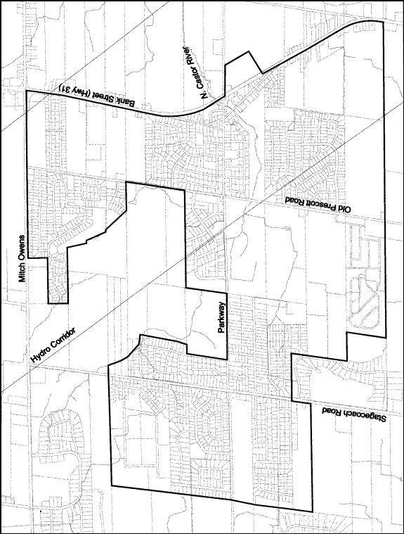
GREELY
LUDS – PROCESS AND TIMELINE Document 2
|
# |
Step |
Date |
|
1 |
Preparation of detailed work program and work schedule |
February 2003 |
|
2 |
Steering Committee meeting #1 – study initiation |
February 20, 2003 |
|
3 |
Compilation, review and analysis of background information |
February – March 2003 |
|
4 |
Steering Committee meeting #2 – review of background information and workshop preparation |
March 18, 2003 |
|
5 |
Workshop – Visioning and development principles |
April 15, 2003 |
|
6 |
Preparation of “existing conditions report” |
May 2003 |
|
7 |
Steering Committee meeting #3 – review of “existing conditions report” and initiation of concept plan alternatives |
May 2, 2003 |
|
8 |
Steering Committee meeting #4 – review of concept plan alternatives and open house preparation |
June 5, 2003 |
|
9 |
Landowner meeting – review of alternative concept plans |
June 11, 2003 |
|
10 |
Open House #1 – review of alternative concept plans |
June 26, 2003 |
|
- |
Study put on hold pending the completion of the Greely Groundwater Modelling study |
July – December 2003 |
|
11 |
Preparation of draft report |
January – February 2004 |
|
12 |
Steering Committee meeting #5 – review of draft report |
February 25, 2004 |
|
13 |
Open House #2 – review of preferred concept plan and draft report |
March 11, 2004 |
|
14 |
Preparation of preferred concept plan final report |
March – April 2004 |
|
15 |
Submission of final preferred report |
May 2004 |
Official Plan Amendments Document 3
1. OFFICIAL
PLAN AMENDMENT NO. ___ TO THE OFFICIAL PLAN FOR THE FORMER TOWNSHIP OF OSGOODE.
2. OFFICIAL PLAN AMENDMENT
NO. ___ TO THE OFFICIAL PLAN (2003) OF THE CITY OF OTTAWA.
