Report
to/Rapport au :
Planning and Environment Committee
Comité de l'urbanisme et de
l'environnement
and Council / et au Conseil
Submitted by/Soumis par : Ned Lathrop, Deputy City Manager/
Directeur municipal adjoint,
Planning and Growth Management /
Service de l'urbanisme et de la gestion de la croissance
Contact Person/Personne ressource : Karen Currie,
Manager / Gestionnaire
Development Approvals / Approbation des
demandes d'aménagement
(613) 580-2424 x28310,
Karen.Currie@ottawa.ca
|
SUBJECT: |
ZONING - 4020 and 4022 Strandherd
Drive (file No. D02-02-05-0117) |
|
|
|
|
OBJET : |
REPORT RECOMMENDATION
That the Planning and Environment
Committee recommend Council approve an amendment to the former City of Nepean
Zoning By-law to change the zoning of 4020 and 4022 Strandherd Drive from
Future Growth (FG) to Residential Mixed Use Exception (RMU Block XX) and to
Residential Sixth Density Exception (R6A Block XX) ; from Residential Fifth
Density (R5) to Parks and Recreation
(Public) (PRP) and Residential Mixed Use Exception (RMU Block XX); from
Institutional (I) to Residential Sixth Density Exception (R6A Block XX); and
Residential Fourth Density (R4) to Residential Mixed Use Exception (RMU Block
XX) as shown on Document 1 and as detailed in Document 2.
RECOMMANDATION DU RAPPORT
Que le Comité de l’urbanisme et de l’environnement recommande au Conseil
d’approuver une modification à l’ancien règlement de zonage municipal de la
ville de Nepean, soit de modifier le zonage du 4020 et du 4022 de la route
Strandherd comme suit : de zone de croissance future (CF) à zone résidentielle
à utilisation mixte assortie d’une exception (RUME, bloc XX) et à zone
résidentielle à densité six assortie d’une exception (R6A, bloc XX); de zone
résidentielle à densité cinq (R5) à zone de parcs et de loisirs (publique)
(PLP) et à zone résidentielle à utilisation mixte assortie d’une exception
(RUME, bloc XX); de zone institutionnelle (I) à zone résidentielle à densité
six assortie d’une exception (R6A, bloc XX) ainsi que de zone résidentielle à
densité quatre (R4) à zone résidentielle à utilisation mixte assortie d’une
exception (RUME, bloc XX) comme le présente le Document 1 et l’explique le
Document 2.
BACKGROUND
The
vacant site is located between Jockvale Road and Gorman Drive, immediately
south of the existing Fraservale community (in Barrhaven) and north of the new
Strandherd Drive realignment.
An
application for Plan of Subdivision for associated lands is now in the final
stages of review and should be receiving draft approval shortly. The Plan of Subdivision proposes a mix of
semi-detached units, street townhouse units and apartment units, along with one
neighbourhood park. The Zoning By-law amendment application proposes 2.5 hectares
of semi-detached lots, 2.4 hectares
for townhouse units, 0.6 hectares of condominium development and .2 hectares
for neighbourhood park space.
This
Zoning By-law amendment will permit the uses being proposed within the
development.
DISCUSSION
City Council Approved Official Plan
and Former Regional Official Plan:
The site is designated as 'General Urban Area'
in both the City Council Approved Official Plan and the former Regional
Official Plan. This designation allows
all types and densities of residential development, as well as park area. The proposed zoning is in conformity with
these policies. The proposed
residential and park uses fully comply with the City Council Approved Official
Plan and former Regional Official Plan policies.
Former City of Nepean Official Plan:
The site is designated as 'Residential' under
the former City of Nepean Official Plan.
This designation allows for all types of residential development and the
proposed zoning is in conformity with these policies.
Secondary Plan:
The site is subject to the South Nepean Urban
Area Secondary Plan - Areas 9 and 10 of the City Council Approved Official Plan
Volume 2A. The site is designated as
'Residential' in this Secondary Plan, which allows a variety of housing types.
This plan sets a unit target of 280 units for this site.
Existing and Proposed Zoning:
The site is a vacant remnant parcel of land
currently zoned as Future Growth - (FG), Residential Fourth Density - (R4),
Residential Fifth Density - (R5), and Institutional - (I). The purpose of this zoning proposal is to
obtain approval to allow for residential semi-detached units, street townhouse
units and apartment condominium units associated with the Plan of
Subdivision. A portion of existing old
Strandherd Drive is to remain open and be integrated into the proposed street
network. This existing portion of road
will also act as a buffer, and transition between the new and existing
communities. A new sidewalk is to be
installed along the south portion of old Strandherd Drive to serve as a future
pedestrian and recreational path linkage between the new and existing
communities and recreational parks.
An exception zoning will been added to
Residential Mixed Use (RMU) and Residential Sixth Density (R6A) as outlined in
Document 2. The Residential Mixed Use
(RMU) exception is to allow for a reduction of yard requirement for any lot
line that abuts old Strandherd Drive.
An existing 11.4 metre boulevard separation between the edge of the curb
to future dwellings will provide more than adequate separation between the
units and the roadway.
The Residential Sixth Density (R6A) exception
is to allow for a 3.0 metre front, rear and side yards; to allow for 1.6 metre
uncovered steps at main entrances and to provide for a density of 77 units
per hectare.
The existing 33.2 metre road allowance (old
Strandherd Drive) abuts the proposed condominium site. This road allowance plus
the 3.0 metre yard setback will provide a total of 36.2 metre separation
distance between the proposed condominium site and the closest rear lot line of
the existing community. The proposed density is consistent with the policies of
the approved Secondary Plan for Areas 9 and 10. The requested height increase for the uncovered steps at the main
entrances has been incorporated into similar condominium plans throughout the
area.
The Department supports the approval of this
application.
CONSULTATION
Notice of
this application was carried out in accordance with the City’s Public
Notification and Consultation Policy. The Ward Councillor is aware of this
application and concurs with the staff recommendation. Detailed responses to the
notification/circulation are provided in Document 3.
FINANCIAL IMPLICATIONS
APPLICATION PROCESS
TIMELINE STATUS
The application was not processed by the
"On-Time Decision Date" established for the processing of Zoning
By-Law amendments due to negotiations associated with final draft approval of
the Plan of Subdivision.
SUPPORTING DOCUMENTATION
Document 1 Location Map
Document 2 Details
of Recommended Zoning
Document 3 Consultation
Details
DISPOSITION
Corporate Services Department, City
Clerk's Branch to notify the owner Tartan Land Corporation, 237 Somerset
Street, West, Ottawa, ON K2P 0J3, Signs.ca, 866 Campbell Avenue, Ottawa,
ON K2A 2C5, and Ghislain Lamarche,
Program Manager, Assessment, Financial Services Branch
(Mail Code: 26-76) of City Council's decision.
Planning and Growth Management Department to
prepare the implementing by-law, forward to Legal Services Branch and undertake
the statutory notification.
Corporate Services Department, Legal Services
Branch to forward the implementing by-law to City Council.
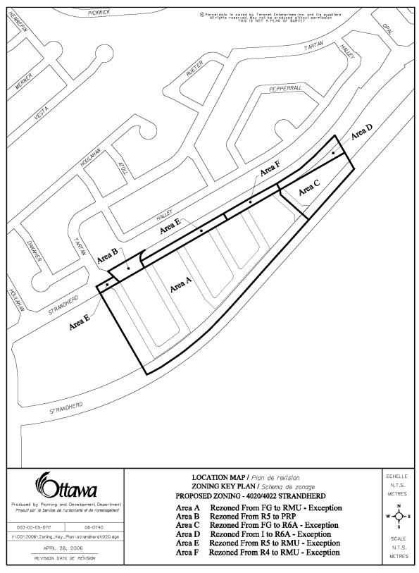
Document 1
LOCATION MAP
Document 2
DETAILS OF RECOMMENDED ZONING
1. The lands know municipally as 4020, 4022 Strandherd Drive are rezoned as follows:
(a) The Area "A" lands on Document 1 to be rezoned from Future Growth Zone - FG to Residential Mixed Use Exception Zone - RMU Block XX.
(b) The Area "B" lands on Document 1 to be rezoned from Residential Fifth Density Zone - R5 to Parks and Recreation - Public Zone- PRP.
(c) The Area "C" on Document 1 to be rezoned from Future Growth Zone - FG to Residential Sixth Density Exception Zone - R6A Block XX.
(d) The Area "D" on Document 1 to be rezoned from Institutional Zone - I to Residential Sixth Density Exception Zone - R6A Block XX.
(e) The Area "E" on Document 1 to be rezoned from Residential Fifth Density Zone - R5 to Residential Mixed Use Exception Zone - RMU Block XX.
(f) The Area "F" on Document 1 to be rezoned from Residential Fourth Density Zone - R4 to Residential Mixed Used Exception Zone - RMU Block XX.
2. A new Residential Sixth Density - R6A Exception zone be created including the following provisions:
(a) Reduce front, rear and side yard setbacks from 7.5m to 3m;
(b) To permit an increase in height of uncovered steps at main entrances from 1.3 metres to 1.6 metres;
(c) To increase the maximum density of 75 units per hectare to 77 units per hectare.
3. A new Residential Mixed Use - (RMU) Exception Zone be created including the following provisions:
(a) The minimum yard requirement from any lot line that abuts old Strandherd Drive to a building is 0 metres
Document 3
CONSULTATION DETAILS
NOTIFICATION AND CONSULTATION PROCESS
Notification and public consultation was undertaken
in accordance with the Public Notification and Public Consultation Policy
approved by City Council for Zoning By-law Amendments one public meetings were
also held in the community on November 22, 2005.
PUBLIC COMMENTS
Concern was raised by the
public regarding the impact of the proposed Residential Sixth Density Zone -
R6A Zone upon the existing Fraservale community:
Response:
The proposed Zoning By-law sufficiently supports the intent of the City Council Approved Official Plan's Secondary Plan - Areas 9 and 10 that clearly indicates that the highest densities should be generally along the southern edges of the community and at major road intersections. The proposed site is located immediately abutting Strandherd Drive; at the intersection of a proposed new road into the community. Staff is of the opinion that the proposed densities are appropriate for this location. There is over 33 metres separation between the existing and proposed development.
Comment:
Will there be some sort of buffer for privacy between existing and proposed homes?
Response:
The maintenance and retention of most of the existing 33.2 metre (old Strandherd Drive) road allowance will provide a separation between existing and proposed homes. In addition, a portion of the existing roadway is to be retained for park purposes.
Comment:
We have concerns regarding potential structural/foundation problems.
Response:
No blasting will take place.
Comment:
Why is a recreational corridor running along the abutting rear yards for both existing and proposed homes?
Response
The updated draft Plan of Subdivision proposes a sidewalk to run along the south side of the existing road allowance. This sidewalk will provide a pedestrian linkage between new and existing communities.
Comment:
Wouldn't the proposed park connection pose a "hang out" for kids and security problem?
Response:
This is a small neighbourhood park intended to service the needs of the immediate area. The location of the park, with two road frontages and abutting residents, will provide good visual security for the site.
Comment:
Where will the parking be for the proposed Java units? Parking area could draw problems to the proposed green space.
Response:
This will be a condominium development which will provide private parking on-site for residents and visitors.
Comment:
What will be the target market for the Java units?
Response:
The developer has indicated that it will be first home buyers and people moving down from larger housing.
Comment:
Why was the site for the Java units located near the entrance to new Strandherd Drive?
Response:
The location is consistent with the policies of the approved Secondary Plan.
Comment:
The proposed plan should be restricted to homes of similar type to the existing subdivision to the north.
Response:
The Official Plan encourages the provision of a mix of housing types within each community. The Secondary Plan for this area identified a unit target which required the provision of more dense housing than the community to the north.
COUNCILLOR’S COMMENTS
The Ward Councillor is in support of the proposed Zoning By-law amendment.