Report
to/Rapport au :
Planning and Environment Committee
Comité de l'urbanisme et de
l'environnement
and Council / et au Conseil
Submitted by/Soumis par : John Moser, Acting Deputy City Manager/
Directeur municipal adjoint par intérim
Planning and Growth Management / Urbanisme et Gestion de la croissance
Contact Person/Personne ressource : Karen Currie,
Manager / Gestionnaire
Development Approvals/ Approbation des
demandes d'aménagement
(613) 580-2424 x 28310,
Karen.Currie@ottawa.ca
REPORT RECOMMENDATION
That the Planning and Environment Committee authorize the Director of Planning and Infrastructure Approvals to grant Draft Subdivision Approval for the Subdivision Application for Part of 4784 and 4798 Bank Street, 4738 and 4742 Bank Street and other lands in Lots 17, 18, 19 and 20, Concession 4, Rideau Front as shown on Document 2 and to the Draft Conditions outlined in Document 3.
RECOMMANDATION DU RAPPORT
Que le Comité de l'urbanisme et de l'environnement
autorise le directeur, Approbation des demandes d'aménagement et d'infrastructure,
à avaliser la demande d'approbation provisoire de lotissement pour une partie
du 4784 et du 4798 de la rue Bank, du 4738 et du 4742 de la rue Bank ainsi que
d'autres terrains des lots 17, 18, 19 et 20, concession 4, façade rivière
Rideau, comme l'indique le Document 2, et les conditions provisoires énoncées
au Document 3.
BACKGROUND
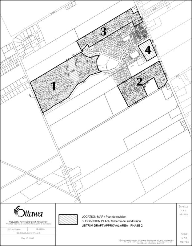
The
subject lands are comprised of four parcels totaling 116.84 ha in the Leitrim
Community generally located north of the Blais Road extension, east of Albion
Road, south of the Hope Cemetery and west of Bank Street. The lands subject to this application are
also referred to as the Stage 2 lands.
The
applicant owns an additional 48.16 hectares to the south and west of a portion
of the subject lands. This parcel consists of the Leitrim Wetlands
which are to be conveyed to the South Nation Conservation Authority in the
future.
Document
1 illustrates the subject site and breaks it into Parcels 1, 2, 3 and 4 for
easier references throughout this report.
The
City Council Approved Official Plan places the subject lands in a 'General
Urban Area' designation. Parcels 1, 2
and 3 are also impacted with a Developing Community overlay. This overlay
designation requires that a Community Design Plan be completed prior to any
development being approved. The Leitrim
Community Design Plan was approved by City Council on July 13, 2005. All parcels are within the Airport Vicinity
Development Zone which identifies land that is impacted by airport noise. The proposed development must also comply
with the provisions of the Ottawa International Airport Zoning regulations.
The
former Regional Official Plan designates Parcels 1, 2, 4 and a small portion of
Parcel 3 as 'General Urban Area' and the majority of Parcel 3 as 'Business Park'.
The
former City of Gloucester Official Plan designates the lands as Residential for
Parcels 1, 2 and 4. The majority of
Parcel 3 is designated Industrial for the lands within Lot 17 and the remaining
lands in Lot 18 are designated Community Commercial. Some of the lands within Parcel 1 have a Unstable Lands
environmental constraint overlay. The
environmental constraint overlay, 'Unstable Land' will remain in place to give
notice to potential purchasers regarding restrictions on development.
The
present zoning for Parcels 1 and 2 is "Fg", Future Growth and "Os", Open Space. The land to the north know as Parcel 3 is
zoned "HMp( R )", Holding, Industrial Park with a water restriction,
"Re1", Residential Estate 1 and "Fg", Future Growth. Parcel 4 was zoned "Cc1",
Commercial Community 1 earlier in 2006.
There
is a candidate Urban Natural Areas Environmental Evaluation Study (UNAEES) site
#108 located along the south side of Findlay Creek abutting Bank Street in
Parcel 2. The Applicant has submitted a
Environmental Evaluation Study which has rated this site as being low and while
it is recommended that the site not be considered for full protection,
perservation of the riparian vegetation along Findlay Creek is to be given
special attention. Further to this,
there was portion of UNA Site #106 that
was identified as originally being in Parcel 1. This portion was removed
and not included in the Leitrim Community Design Plan as these lands have
development status.
The Ward Councillor removed Delegated Authority approval for this subdivision application on January 10, 2006 and consequently, the application has proceeded to Planning and Environment Committee.
DISCUSSION
The original subdivision application for these lands, which will complete the development of the applicant owned lands in Leitrim, was submitted in 1994. The second submission for these lands was circulated in July 2003. The draft approval for Leitrim - Stage 2 was deferred until the Leitrim Community Design Plan was approved and until the build out of the Stage 1 area was nearing completion.
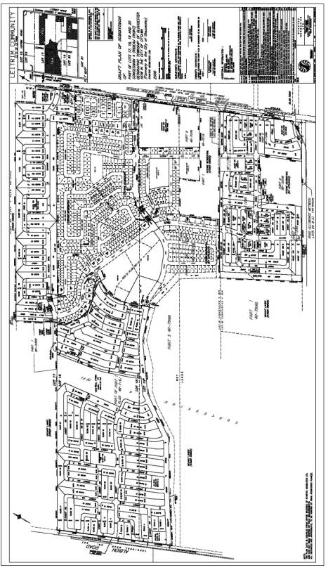
The applicant is now seeking draft approval of these lands. The subdivision consists of approximately 1936 dwelling units consisting of single family homes, semi-detached units, townhouses and apartments. Also proposed are two neighbourhood parks and a large centralized park.
The subject lands have gone through an extensive design exercise as part of the Leitrim Community Design Plan process. The draft subdivision plan was revised to closely align with and fulfill the intent of the Leitrim Community Design Plan which was approved on July 13, 2005.
A full range of housing choices, commercial and recreational uses are offered within this fully seviced phased community. The applicant is proposing to construct 1351 low density units (singles and doubles), 321 medium density units (townhouses) and 264 apartments. A neighourhood commercial use, two neighbourhood parks, one community park, an overland flow drainage corridor together with a 30 metre Buffer Area abutting the Leitrim Wetland and a 15 metre buffer strip along Findlay Creek are also shown on the Draft Plan.
Due to the phased development of this large subdivision, zoning will be brought forward once the detailed land use has been determined.
The servicing of this subdivision is a continuation of the existing services within the Findlay Creek Village - Stage 1 area. There has also be continuous dialogue with the adjacent land owner to the south to coordinate the servicing between this Leitrim Stage 2 area and the additional urban lands to the south.
As a result of review of the draft subdivision plan, some adjustments must be made to the plan and staff is recommending several special subdivision conditions to require the final subdivision plans to be to the satisfaction of the Director of Planning and Infrastructure Approvals.
It is recognized that the Leitrim Wetland is not within this draft approval area but site specific subdivision conditions have been structured to protect the Leitrim Wetland from uncontrolled human encroachment and disturbance.
In recognition of the fact that this subdivision application was filed in 1994 and acknowledging that there now exists a substantial number of homes in Findlay Creek Village, a public information meeting was held on February 23, 2006. The major issue at this meeting was the extension of Meadowlilly Road north to Stalwart Drive as shown in Parcel 3. The residents' concerns were centred around the introduction of a roadway connection and the additional traffic that may be generated along Meadowlilly Road and Devonwood Circle. Several residents felt that the extension of Meadowlilly Road north to Stalwart Drive would encourage cut through traffic onto their streets. Due to the fact that the Meadowlilly Road extension is not scheduled to be developed for approximately five years, the developer agreed to conduct a traffic analysis, at that time, as set out in Condition 29. It was also suggested by the residents that if a roadway link was determined not to be required that a walkway link should be provided.
Further to this issue,
residents expressed concerns over traffic issues on existing local streets.
There was a request tabled to close Tundra Swan Way and Bucknell Drive to limit
cut through traffic. Although these
traffic concerns were outside the Leitrim - Stage 2 Draft Plan Area, the
residents were confident that Condition 29 would examine this matter fully in
the future. This negotiated approach to
resolve the traffic concerns was well received by those in attendance at the
meeting.
Other matters that were tabled by the residents and briefly discussed at the public information meeting included: the need for a community centre for Findlay Creek Village as the Fred Barrett Complex is too removed from the community and the timing of park development to properly service the growing community. The Ward Councillor committed to discussing the need for a community centre with the developer and the City's Park and Recreation Department has been made aware of these issues.
The residents in attendance at the meeting also requested notification of any further meetings and/or changes to the proposed plan.
Staff is satisfied that this Draft Subdivision Plan does meet the intent of the City Council Approved Official Plan by providing a compact, land use mix that offers a full range of housing choices, and commercial component with recreational options, all of which emphasize walking, cycling and transit opportunities within Leitrim.
CONSULTATION
Notice
of this application was carried out in accordance with the City's Public
Notification and Consultation Policy as the policy relates to subdivision
application filed prior to 1996. The
Ward Councillor is aware of this application and the staff
recommendations. A Public Information
Meeting for this subdivision was held on February 23, 2006. There were 31 people in attendance and
concerns were expressed relating to increase of traffic on existing streets and
environmental issues. A special
subdivision draft condition to deal with the major traffic issues was tabled at
the meeting. All parties agreed to the intent of the draft condition which
allows the opportunity to revisit the issue at the time further development
triggers traffic issues.
The City has received comments and opposition to this application due to the environmental sensivity of the area. The approved Leitrim Community Design Plan has addressed these concerns and objections as part of the public process. Document 4 summarizes the public comments received.
FINANCIAL IMPLICATIONS
APPLICATION PROCESS
TIMELINE STATUS
This application was not processed by the 'On-Time
Decision Date" established for the processing of subdivision applications
as this is a 1994 application and was subject to the applicant's own agenda and
willingness to wait for the Leitrim Community Design Plan to be approved.
SUPPORTING DOCUMENTATION
Document 2 "Draft Plan of
Subdivision of Part of Lots 18, 19 and 20, Concession 4 (Rideau Front),
Geographic Township of Gloucester, Now in the City of Ottawa (formerly in the
City of Gloucester)" prepared by Stantec Geomatics Ltd on behalf of
1374537 Ontario Ltd./Findlay Creek Properties Ltd. being Submission 5 and
received by the City on May 23, 2006.
Document 3 Conditions of Draft Subdivision Approval
Document 4 Consultation
DISPOSITION
Planning and Growth Management Department to notify the owner: Pierre Dufrense, 1374537 Ontario Ltd/Findlay Creek Properties Ltd, Tartan Land Corporation, 237 Somerset Street West, Ottawa, Ontario K2P 0J3 and all interested parties of Planning and Environments Committee's decision.
File: D07-16-03-0020
Ref.
File: 15-94-0512
S-LE-94-10
CITY OF OTTAWA
CONDITIONS FOR DRAFT APPROVAL
1374537 ONTARIO LTD./FINDLAY CREEK SUBDIVISION – STAGE 2
LEITRIM GROWTH AREA
The City of Ottawa's conditions applying to the approval of the final plan for registration of the 1374537 ONTARIO LTD./FINDLAY CREEK Subdivision – Stage 2, Part of 4784 & 4798 Bank Street, 4738 & 4742 Bank Street, Part of Lots 17, 18, 19 and 20, Concession 4 Rideau Front in the former City of Gloucester, now in the City of Ottawa are as follows:
|
|
General |
|
|
|
|
|
This approval applies to the Draft Plan of
Subdivision certified by D.A. Simmonds, Stantec Geomatics Ltd. dated May 23,
2006 showing 161 Blocks for single family dwellings, semi-detached dwellings,
row housing and apartments, 1 Commercial Block, 1 Block for an overland
drainage corridor, 4 Blocks for private open space, 4 Blocks for Parks with
several Blocks for walkway purposes, 2 – 30 metre Buffer Blocks, 3 – 15 metre
Buffer Blocks, and 37 streets. |
|
|
|
|
|
The Owner shall comply and implement the following reports and any
subsequent revisions or updates: 1. Geotechnical
Overview, Leitrim Lands Development, Ottawa, Ontario, prepared by Golder and
Associates, Project No.: 05-1120-179, November 4, 2005 2. Tartan’s
Leitrim Lands, Overview of Proposed Unit Count and Transportation
Requirements, prepared by Delcan Corporation, File Number: SO1153SOJ00 dated
November 8, 2005. 3. Findlay
Creek Retail Site, Transportation Overview, prepared by Delcan Corporation,
File SO1153O100 dated July 27, 2005. 4. Findlay
Creek Village (Leitrim Community) Phase 2, Stage 1 Preliminary Tree Planting
and Conservation Plan, File Number: 573.05 dated September 27, 2005. 5. Urban
Natural Area 108, Bank Street, north of Blais Road, Environmental Review,
prepared by Muncaster Environmental Planning dated July 10, 2005. 6. Sample
Analysis Results for Monitoring Wells prepared by Transport Canada –
Environmental Affairs, Program and Divertiture, File Number AHE 7075-75-0137
dated October 6, 2005. |
|
|
|
|
|
7. Leitrim Development Area (Serviceability Report) prepared by
Cummings Cockburn Limited, File Number: 3614-LD-03 dated November 18, 2005. |
|
|
|
|
|
The Owner agrees, by entering into subdivision agreements, to satisfy all requirements, financial and otherwise, of the City of Ottawa, including but not limited to, the phasing of the plan for registration, the provision of roads, installation of services and utilities (including oversizing), and drainage, in accordance with City Specifications and Standards all to the satisfaction of the City. |
OTTAWA (PGM) |
|
|
|
|
The Owner acknowledges that this subdivision will not be cleared for registration prior to reaching satisfactory arrangements for the provisions of adequate water supply and sewer service to the proposed subdivision. |
OTTAWA (PGM) |
|
|
|
|
The Owner acknowledges that South Nation Conservation Authority is under agreement with the Department of Fisheries and Oceans Canada to screen works that are in or beside water. The impacts that any such works may have on fish habitat, whether directly adjacent to the site or downstream, will necessitate a review by the Conservation Authority and may require approval of the Department of Fisheries and Oceans Canada. |
SNC |
|
|
|
|
The Owner shall be responsible for
the provision of the following services, including over sizing, at its cost,
to the satisfaction of the City and/or the Province: a) watermains
b)
sanitary
sewers c) storm sewers d) roads e) street lights f) sidewalks & recreational
pathways c)
landscaping d)
street name and traffic signs e)
stormwater management facilities. |
OTTAWA (PGM) |
|
|
|
|
The Owner shall provide a Phase 1 Environmental Site Assessment for the land subject to this draft approval prior to the registration of the first phase of development. |
OTTAWA (PGM) |
|
|
|
|
The Owner shall remove any debris from the site and dispose of the debris in accordance with provincial regulations prior to any site works being undertaken. |
OTTAWA (PGM) |
|
|
|
|
The Owner acknowledges and agrees that all reports and/or studies required as a result of the approval of the Plan of Subdivision shall be implemented to the satisfaction of the City at the sole expense of the Owner. Further, that the City may require certification by the Owners Professional consultants that the works have been designed and constructed in accordance with the approved reports, studies, standards specifications, and plans to the satisfaction of the City. |
OTTAWA (PGM) |
|
|
|
|
The Owner shall provide, at no cost to the City, a 10 metre wide easement in favour of the City over the proposed Cedar Creek Drive, between Street 25 and the lands to the south (Remer/Minto). |
OTTAWA (PGM) |
|
|
|
|
The Owner shall provide, at no cost to the City, a 10 wide metre easement in favour of the City along the west side of the easement described in Condition 8 above. This easement is to be negotiated with federal authorities having ownership of said lands. Failing the registration of this easement, the 0wner will register a 10 metre wide easement on Blocks 165 & 163, along the eastern side of the easement mentioned in Condition 8 above. (i.e. total easement width of 20 metre on Owner’s property) |
OTTAWA (PGM) |
|
|
|
|
The Owner acknowledges the fact that should it not be successful in the registration of the western portion of the 10 metre easement mentioned on Condition 9, that Cedar Creek Drive will need to be realigned using the 20 metre easement on the Owner’s property. The Owner acknowledges that developable lands may be adversely affected from abutting Blocks. |
OTTAWA (PGM) |
|
|
|
|
The alignment of two internal road connections (Cedar Creek & Kelly Farm Drives) as well as storm, sanitary and water distribution issues need to be coordinated with the subdivision application to the south (Remer/Minto Lands). The Blais Road upgrade to a 24 metre municipal standard cross section, access, road patterns, drainage and servicing as well as issues mentioned in the Master Servicing study referred to in Condition 107 will have to be addressed to the City of Ottawa’s satisfaction prior to final approval of the subdivision plan to be registered. |
OTTAWA (PGM) |
|
|
|
|
The Owner shall indicate the 1:100 year water level for Findlay Creek on the draft plan and revise the Buffer Blocks 182, 183 & 184 and part of Block 169 layout if required to ensure the 100-year water level falls within said blocks. This shall be done to the satisfaction of the City of Ottawa and South Nation Conservation Authority. |
OTTAWA (PGM) SNC |
|
|
|
|
The Owner shall provide a minimum 20-metre wide road right of way over Street 25 subject to the Owner’s Engineer providing documentation satisfactory to the City of Ottawa with regards to the feasibility of a large diameter storm culvert on such roadway width. (A larger ROW may be required) |
OTTAWA (PGM) |
|
|
|
|
The right of way widths for the following roads are to be revised and shown on the plan as follows; ROW required Street From To 16.5 metres 21 Stalwart Dr.
Stalwart Dr. 11 Northern Limit Findlay Creek Drive of application 18 metres 1 Block 17 Findlay Creek Drive 5 Street 3 Findlay Creek Drive 6 Street 3 Findlay Creek Drive 9 Block 57 Findlay Creek Drive 3 Street 1 Findlay Creek Drive Bradwell Way Kelly Farm Drive Findlay Creek Drive 20 metres min. Refer to Condition 13 25 Kelly Farm Dr. Street No. 30 This shall be to the satisfaction of the Director, Planning and Infrastructure Approvals. |
OTTAWA (PGM) |
|
|
|
|
The Owner shall be required to pay his share
of cost for any municipal service as provided by others and as determined by
the Director, Planning and Infrastructure Approvals Branch. |
OTTAWA (PGM) |
|
|
|
|
The Owner shall obtain such
permits as may be required from Municipal or Provincial authorities and shall
file copies thereof with the Director of Planning and Infrastructure
Approvals. |
OTTAWA (PGM) |
|
|
|
|
Any residential blocks on the final plan shall be configured to ensure that there will generally be no more than 25 units per block. |
OTTAWA (PGM) |
|
|
|
|
Prior to registration of any phase, the Owner shall submit a phasing plan to the City of Ottawa for approval. |
OTTAWA (PGM) |
|
|
|
|
The Owner shall build as many
units as possible with a south-facing exposure oriented within 25 degrees of
the true east/west axis to the satisfaction of the City. |
OTTAWA (PGM) |
|
|
|
|
Prior to any further division of lots or blocks, the City of Ottawa may require an additional agreement to address any new or amended conditions. |
OTTAWA (PGM) |
|
|
|
|
The Owner shall orient all driveway accesses for residential units onto the internal streets. |
OTTAWA (PGM) |
|
|
|
|
The Owner shall convey to the City,
all lands required for public purposes, including but not limited to,
reserves, road widenings, daylighting triangles, walkway blocks, open space
blocks, lands required for parks or cash-in-lieu thereof and for storm water
measures, to the satisfaction of the Director, Planning and Infrastructure
Approvals. |
OTTAWA (PGM) |
|
|
|
|
The Owner shall
acknowledge and agree that any dead ends and/or open spaces of road allowances created by this
plan of subdivision shall be terminated in 0.3-meter reserves to be conveyed
to the City. This shall include a 0.3-meter reserve along any temporary
turning circle(s). |
OTTAWA (PGM) |
|
|
|
|
The Owner shall acknowledge the following conditions as related to Building Permits: a) Prior to placement of Granular "A" road bedding, the Owner shall acquire approval of the City to ensure that Granular "B" materials are not contaminated. The above shall also apply prior to placement of base course asphalt as it relates to approval of the Granular "A" materials. b) The Owner shall not demand of the City to issue, nor shall anyone claiming title from it or under its authority, demand of the City to issue, one or more building permits to construct any building or other structure on any lot or block on the Site until: i) All roads on the Site have been connected to a public street. ii) Access for fire fighting equipment has been provided to each building by means of a street or private roadway, which shall be designated and posted to the satisfaction of the Director, Planning and Infrastructure Approvals and Fire Chief. iii) The
access route has been surfaced with concrete, asphalt, or Granular
"A" base capable of permitting accessibility under all climatic
conditions and is continuously maintained so as to be immediately ready for
use by the Emergency and Protective Services Department vehicles or any other
vehicles in the event of an emergency. iv) The City has approved, where applicable, a site plan, a grading plan and a design plan for the proposed building or structure |
OTTAWA (PGM) |
|
|
|
|
Upon registration of the plan of
subdivision (i.e. Plan 4M-_____), the Owner shall submit to the
Director, Planning and Infrastructure Approvals, a chronoflex reduction of
said plan. The reduction shall be to
a size of 8-1/2" x 14". |
OTTAWA (PGM) |
|
|
|
|
Zoning |
|
|
|
|
|
Prior to registration of the plan of subdivision, the proposed plan shall conform with a Zoning By-law approved under the requirements of the Planning Act, with all possibility of appeal to the OMB exhausted. |
OTTAWA (PGM) |
|
|
|
|
The Owner shall provide certification of Zoning By-law compliance prepared by an Ontario Land Surveyor for all lots and blocks prior to the registration of the plan of subdivision. |
OTTAWA (PGM) |
|
|
|
|
Highways/Roads |
|
|
|
|
|
The Owner shall
undertake a Transportation Impact Study certified by a Professional Engineer
with expertise in undertaking such studies which complies with the City of
Ottawa’s Transportation Impact Study Guidelines in identifying Transportation
Demand Management measures and analyzing traffic impacts, transit impacts and
implications for pedestrian and bicycle movements. The methodology and
analysis principles shall be to the satisfaction of the Director, Planning
and Infrastructure Approvals. The Owner further agrees to revise the Draft
Plan in accordance with the recommendations of the study to the satisfaction
of the City of Ottawa. |
OTTAWA (PGM) |
|
|
|
|
Prior to the registration of each phase of subdivision, the Owner shall prepare traffic analysis that will consider the warrants and implementation of traffic calming measures and traffic signalization for the lands subject to the plan registration, as well as for any measures recommended to be installed on the Findlay Stage 1 lands. Prior to the registration of each subdivision plan, the Owner shall post security for the recommended measures of the traffic analysis. |
OTTAWA (PGM) |
|
|
|
|
The Owner shall revise the eastern intersection of Street 21 and Stalwart Drive to deter through traffic on this crescent street to the satisfaction of the Director of Planning and Infrastructure Approvals. |
OTTAWA (PGM) |
|
|
|
|
The Owner agrees to construct Blais Road (Street 31) as a 24 metre municipal standard cross section for the portion within this draft plan of subdivision. |
OTTAWA (PGM) |
|
|
|
|
The Owner shall provide temporary turn-arounds for all streets terminating at the edge of any phase of development, prior to registration, to the satisfaction of the City of Ottawa. |
OTTAWA (PGM) |
|
|
|
|
The Owner shall convey to the City, at the Owner’s expense, an unencumbered road widening along Bank Street, measuring 22.25 meters from the existing centerline of pavement, and an unencumbered road widening along Albion Road, measuring 18.75 meters from the existing centerline of pavement. The Owner shall dedicate the proposed streets, shown on the M-plan, as public highways, to the City of Ottawa. The Plan shall have ties to the Horizontal Network and be submitted in draft to the City Surveyor for review and approval. |
OTTAWA (PGM) |
|
|
|
|
The Owner shall provide, at its’
expense, a 0.3 meter reserve adjacent to the widened limit of Bank Street and
Albion Road on the following locations: a)
Blocks
7, 8, 12, 13, 17 &, 83 facing Albion Road b) Blocks 120, 156, 158, 166, 167 & 168 facing Bank Street |
OTTAWA (PGM) |
|
|
|
|
The design of all
road intersections, including geometric, intersections spacing, grades, the
conveyance of the necessary sight triangles and required 0.3 meter reserves
necessary for lot access control or until the future construction of road
extensions or future development of adjacent lands, shall be to the
satisfaction of the City of Ottawa. |
OTTAWA (PGM) |
|
|
|
|
The Owner shall
be responsible for 100% of the cost and installation of all permanent and
temporary street name signs and traffic signs that may be required in
accordance with City specifications. All signs shall be installed and located
to the satisfaction of the City and installed prior to the City’s acceptance
of the roads within the subdivision. |
OTTAWA (PGM) |
|
|
|
|
The Owner shall conform to the City's Street
Numbering By-law. |
OTTAWA (PGM) |
|
|
|
|
All streets shall be named to the satisfaction of the City’s Planning and Growth Management Department. |
OTTAWA (PGM) |
|
|
|
|
The Owner is required to remove all spill, dirt, mud, stone or other transported material from all roads at the end of each day during construction. However, should this material at any time pose a hazard to vehicles or pedestrian, the Owner shall clean the road immediately. In the event of a dispute, the Director, Planning and Infrastructure Approvals, or his designate, will be the judge of what constitutes a hazard. In the event that the material is not removed as required, the material may be removed by the City at the expense of the Owner. |
OTTAWA (PGM) |
|
|
|
|
Public Transit |
|
|
|
|
|
The Owner shall
design and construct, at its expense; all streets which have been identified
as transit service routes, to TAC standards, including right-of-way width,
horizontal and vertical geometry, and pavement structure, paved transit
passenger standing areas, or shelter pads and shelters, to the specifications
of OC Transpo, and the construction of a sidewalk on both sides of the
street(s) |
OTTAWA (PGM) |
|
|
|
|
Prior to submitting the final registration plan for each phase, the Owner acknowledges and agrees to submit for approval a preliminary lotting plan to determine that the proposed lot and/or block frontages do meet the requirements of OC Transpo, Canada Post and the City with respect to bus stops, community mail box locations, and snow storage. This shall be to the satisfaction of the Director, Planning and Infrastructure Approvals.
|
OTTAWA (PGM) |
|
|
|
|
The Owner shall: a) orient dwellings and vehicular accesses in the vicinity of bus stops in a manner as to avoid traffic conflicts and visual intrusion and to submit plans for approval by the City of Ottawa indicating the orientation of all dwellings and private accesses in the vicinity of all bus stop locations; b) inform all prospective purchasers, through a clause in all agreements of purchase and sale and indicate on all plans used for marketing purposes, those streets identified for potential transit services, the locations of the bus stops, paved passenger standing areas, or shelter pads and shelters, which may be located in front of or adjacent to the purchasers' lots at any time. |
OTTAWA (PGM) |
|
|
|
|
The Owner shall design and construct, at no cost to the City of Ottawa, paved transit passenger standing areas, or shelter pads and shelters, to the specifications of OCTranspo. |
OTTAWA (PGM) |
|
|
|
|
The Owner shall
ensure that the staging of the subdivision, including dwellings, roadways,
walkways and paved passenger standing areas, or shelter pads and shelters,
will be constructed in a sequence that permits the operation of an efficient,
high-quality transit service at all stages of development. In accordance with this requirement, the
provision of transit service to this development will be staged by the City
of Ottawa to coincide with dwelling occupancy. |
OTTAWA (PGM) |
|
|
|
|
City Roadway Modification |
|
|
|
|
|
The Owner shall pay all expenses including but not limited to land acquisition, contract drawings preparation, utility relocations, advertising, road work, traffic signal lights installation, construction supervision, as built drawing preparation, and other engineering and administrative costs for the modification of any intersection(s) and installation of an additional traffic lane(s) along any affected road as recommended by the approved study (s). |
OTTAWA (PGM) |
|
|
|
|
Geotechnical |
|
|
|
|
|
The Owner shall submit a Geotechnical report prepared by a Geotechnical Engineer, licensed in the Province of Ontario containing detailed information on Geotechnical matters and recommendations pertaining to but not limited to the following; a) the existing sub-surface soils, groundwater condition b)
slope stability and erosion protection, in addition to
any building construction requirements adjacent to unstable slope c)
design and construction of underground services d)
design and construction of internal roadways, fire
routes and parking lots e)
Design and construction of retaining walls and/or slope
protection f)
Design and construction of engineered fill g)
Design and construction of building foundations h)
Site dewatering i)
Design and construction of swimming pools The report shall provide recommendations to address any of the latter
situations to the satisfaction of the City. |
OTTAWA (PGM) |
|
|
|
|
The Owner shall retain the services of the previously referred to Geotechnical Engineer to ensure that the recommendations of the report are fully implemented to the satisfaction of the City of Ottawa. |
OTTAWA (PGM) |
|
|
|
|
The Owner shall have topographical
surveys completed beyond the boundaries of rear and side yards of lots
adjacent the new proposed lots for the purposes of drainage water
control. This shall be to the
satisfaction of the City of Ottawa.
The developer shall obtain all necessary access permission to carry
out this work at his cost. |
OTTAWA (PGM) |
|
|
|
|
The Owner shall submit for
approval detailed grading and drainage plans for this subdivision, prepared
by a Civil Engineer licensed in the Province of Ontario, to the Director of
Planning and Infrastructure Approval. |
OTTAWA (PGM) |
|
|
|
|
The Owner shall provide services oversized and overdepth to service
lands beyond the limits of the subdivision as required and to the
satisfaction of the City of Ottawa. |
OTTAWA (PGM) |
|
|
|
|
Where the Owner
is required under this Agreement to provide and install sanitary sewers of a
diameter larger and/or at a greater depth than would be required to service
the area to be developed, as detailed in the approved plans of this
agreement, the Owner shall convey to the City such 0.3m reserves as may be
necessary to prevent the owners and developers of adjacent lands from making
connections to the sanitary sewers installed by the Owner. Insofar as it
legally may, the City will require other persons connecting to the sewer to pay
an equitable share of the cost thereof to the Owner, the amount of which
payment shall be determined by the Director, Planning and Infrastructure
Approvals. |
OTTAWA (PGM) |
|
|
|
|
Where the Owner
is required under this Agreement to provide the oversize and/or over-depth
storm sewers or open drains in order to make provisions for later development
of upstream lands not owned by the Owner herein, as referred to in the
approved plans, the City shall, insofar as it legally may, require that
payment shall be made by the Owner of such upstream undeveloped land which
will utilize the said storm sewers as an outlet(s), prior to the approval of
a Plan of Subdivision for such land by the City, the amount of which shall be
determined by the Director, Planning and Infrastructure Approvals. |
OTTAWA (PGM) |
|
|
|
|
As the Owner proposes a road allowance(s) of less than 20 meters, and if the Owner also proposed boulevards between 4.0 and 5.0 meters wide, the Owner shall meet the following requirements: a. Extend water, sanitary, and storm services a minimum of 2.0 meters onto private property during installation before being capped. b. Install hydro high voltage cable through the transformer foundations to maintain adequate clearance from the gas main. c. Provide and install conduits as required by each utility. d. Provide and install transformer security walls when a 3.0 meters clearance, as required by the Electrical Code, cannot be maintained. The design and location of the security wall must be approved by the local hydro utility. e. Install all road crossing ducts at a depth not to exceed 1.2 meters from top of duct to final grade. |
OTTAWA (PGM) |
|
|
|
|
The Owner shall retain the
services of a Civil Engineer or Ontario Land Surveyor to certify to the City
of Ottawa that the final lot grading is within 0.15 metres of the approved
grades on the grading and drainage plan. |
OTTAWA (PGM) |
|
|
|
|
The Owner shall have a Civil
Engineer or Ontario Land Surveyor certify the elevation of the top of
footings prior to completion of the foundation walls, and the Owner shall
remove said footing if found to be out by more than 0.1 metre from the
approved design grading plan. Said
elevation shall be submitted by the Civil Engineer or Ontario Land Surveyor
to the City for approval prior to the completion of the foundation walls. |
OTTAWA (PGM) |
|
|
|
|
The Owner shall submit an as-built
grading plan showing actual ground elevations to geodetic datum at front,
rear and side of house, driveway at curb and at garage, all lot corners,
swale, inverts, terraces and top and bottom of retaining walls. The grades must be taken under the
supervision of a Civil Engineer or Ontario Land Surveyor. |
OTTAWA (PGM) |
|
|
|
|
The Owner shall have competent professional engineering inspection personnel on site at all times during the period of construction to supervise the Works and the Director, Infrastructure Services shall have the right at all times to inspect the installation of the Works. Should it be found in the sole opinion of the Director, Infrastructure Services that such personnel are not on site or are incompetent in the performance of their duties, or that the said Works are not being carried out in accordance with approved plans or specifications and in accordance with good engineering practice, then the Director, Infrastructure Services may order all work in the project to be stopped. |
OTTAWA (PGM) |
|
|
|
|
Sidewalks, Walkways, and Fencing |
|
|
|
|
|
The Owner is responsible to build a recreational pathway on Block 185 south of Findlay Creek Drive as identified in the Leitrim Community Design Plan. If the recreational pathway is not built within 5 years from the date of registration of the Plan of Subdivision then the Owner will be responsible to build a sidewalk on the south side of Findlay Creek Drive. |
OTTAWA (PGM) |
|
|
|
|
The Owner shall install and
maintain, at its expense, a barrier in the form of a 1.5 metre high vinyl
covered chain link fence to the City standard along the common boundary line
of developed land and parkland or constraint lands. Said fence shall be located 0.15 metres inside the property
line on private property and shall be to the satisfaction of the City of
Ottawa. Where parkland abuts
residential land, gates will be allowed in designated locations as approved
by the City upon application and at the expense of the homeowner. Gates are to be self-locking and opening
onto (into) private property. Gates
will not be allowed along constraint lands where storm water management areas
occur. |
OTTAWA (PGM) |
|
|
|
|
The Owner shall provide a 1.8 metre high wooden privacy fence along the residential rear lot lines where they abut the commercial block to the satisfaction of the City of Ottawa. |
OTTAWA (PGM) |
|
|
|
|
The Owner shall agree to design and construct, at no cost to the City sidewalks to the specifications of the City of Ottawa in the following locations: Street Location From To 1 East Side Block 17 Findlay Creek Dr. 6 West Side Street 10 Findlay Creek Dr. 9 East Side Block 57 Street 3 3 North Side Street 1 Findlay Creek Dr. 11 West Side North Limit Findlay Creek Dr. 12 West Side North Limit Street 13 Bradwell Way East Side Kelly Farm Dr. Findlay Creek Dr. 13 South Side Street 11 Bradwell Way Findlay Creek Dr. North Side Albion Road Bradwell Way South (Cond. 58) Albion Road Bradwell Way Stalwart Dr. South Side Bank Street Kelly Farm Dr. West Block 175 Block 175 East Block 100 Block 100 Cedar Creek Dr. East Side North Limit Bl. 184 Findlay Creek Dr. Kelly Farm Dr. E & W Side South Limit Street 25 North Side Kelly Farm Dr. Cedar Creek Dr. Street 31 North Side East Limit Cedar Creek Dr. This shall be to the satisfaction of the Director of Planning and Infrastructure Approvals. |
OTTAWA (PGM) |
|
|
|
|
Land/Streetscaping |
|
|
|
|
|
The Owner shall supply to the City
a Landscape Plan for approval prior to final subdivision plan registration
and the Owner agrees to implement the streetscape plan. Said plans shall be prepared by a
Landscape Architect registered in the Province of Ontario and implemented by
a qualified Horticulturist, Nurseryman or Landscape Contractor. |
OTTAWA (PGM) |
|
|
|
|
The Owner shall acknowledge and
agree that any future City or Conservation Authority owned trees in conflict
with future road allowances or at the rear of building lots must be pruned
and/or removed prior to conveyance of the Blocks to the City or South Nation
Conservation to eliminate safety hazards. |
OTTAWA (PGM) |
|
|
|
|
Parks |
|
|
|
|
|
The Owner covenants and agrees that Blocks 175 and 176 shall be conveyed to the City, at no cost, as dedicated parkland. |
OTTAWA (PGM) |
|
|
|
|
The Owner acknowledges that as set out in the Leitrim Community Design Plan, a neighbourhood park is required in the southerly parcel of the subdivision. The neighbourhood park (Block 169) will have an approximate size of 0.8 hectares. The Owner agrees to negotiate the final configuration and size of this park with the City and South Nation Conservation prior to the submission of the final 4M-plan for the subdivision phase that contains Block 169. This park shall be to the satisfaction of the Director of Planning and Infrastructure Approvals and conveyed to the City, at no cost, as dedicated park. |
OTTAWA (PGM) |
|
|
|
|
The Owner acknowledges that as set out in the Leitrim Community Design Plan, that the southerly portion of a community park is required in the area of Block 177. This portion together with a portion of land to the north will create a community park having a total approximate size of 10.6 hectares. This community park will be developed with active park facilities. The Owner agrees to negotiate with the City the final park block configuration and size recognizing that a 18 metre wide corridor must be provided in the area of Block 190 for an overland drainage ditch prior to the submission of the final 4M-plan for the subdivision phase which includes all or part of Block 177. The final park block size and configuration together with the financial arrangements for parkland over dedication, if required shall be to the satisfaction of the Director of Planning and Infrastructure Approvals. |
OTTAWA (PGM) |
|
|
|
|
The Owner acknowledges and agrees that any park block containing any vegetation shall automatically be considered a tree preservation zone until Park Development Plans are received and approved by the Director, Parks and Recreation. |
OTTAWA (P&R) |
|
|
|
|
The Owner shall provide a separate legal survey plan of all park blocks. This plan shall be at a scale of 1:500 in both digital (compatible with current City software application) and reproducible format and shall be to the satisfaction of the Director, Parks and Recreation. |
OTTAWA (PGM) (P&R) |
|
|
|
|
The Owner shall install temporary fencing in accordance with standards approved by the Director, Parks and Recreation in the following locations: a) Around the perimeter of park block(s) prior to the commencement of construction on lands adjacent to the park block(s); b) Adjacent to road frontages. This fencing shall be kept in good repair until the City approves its removal. |
OTTAWA (PGM) (P&R) |
|
|
|
|
The following information is
required by the City of Ottawa prior to acceptance of a parkland block: a) A
topographic plan with the property boundaries identified, signed by a registered
Ontario Land Surveyor. The scale of
drawing shall be 1:500 with a contour interval of 0.5 of a metre (or as
approved by the Director, Parks and Recreation). Spot elevations are required at all property corners ten metres
on centre where the parkland abuts a roadway (i.e. along the curb line). All service connection locations are to be
identified on said plan. a) Existing
Vegetation Plan for the subdivision. b) A copy of the
Class 1 Environmental Assessment. c) A copy of the
draft stormwater report and/or hydrogeological report. d) A coloured
aerial photograph of the park block and surrounding context. e) A copy of the
soil report prepared under the agreement which must determine the following: ·
suitability
of soil as a founding stratum ·
possibility
of soil contamination ·
existence
of perched water table ·
subsurface
preparation required (if in excess of typical preparation practices) to construct on-grade facilities (eg: playing fields) -MINIMUM: 1 bore hole per 1.5
hectares to a depth of 2.0 metres,
installation of stand pipes in at least 40% of bore holes, date and site
conditions at time of survey a) It is the
responsibility of the Owner to clearly demonstrate to the Director of Parks
and Recreation that soils in all designated parks are satisfactory for the purposes
for which the City intends the use of the park. b) More detailed
soils investigation may be required in specific park blocks, to be determined
by the Director, Parks and Recreation. Upon review of
the above-noted information if any remedial work is necessary to make the
park developable, this shall be at the cost of the Owner and to the
satisfaction of the Director, Parks and Recreation. The estimated costs for this work to be included in to Schedule
of Costs in the Agreement and shall not be considered part of any
cash-in-lieu of parkland contribution.
A schedule for the completion of any required remedial works must be
submitted to the Director, Parks and Recreation. The schedule must indicate substantial completion of all
remedial work prior to the issuance of the first building permit. |
OTTAWA (PGM) (P&R) |
|
|
|
|
The Owner shall, unless otherwise modified and as part of the required works, and at no cost to the City, provide, at a minimum, the following services and utilities to the future park blocks: a) A 300 mm diameter storm sewer and CB/MH at 2 metres inside the park property line. b) A 50 mm diameter water line complete with a valve chamber at 2 metres inside the park property line. c) A 120/240 volt, 400 ampere single phase hydro service and panel at 2 metres inside the park property line. d) A 150 diameter sanitary sewer and manhole at 2 metres inside the park property line. |
OTTAWA (PGM) (P&R) |
|
|
|
|
If servicing plans indicate the
location of above-grade or below-grade infrastructure is placed such that it
will interfere with the park development, where possible, the infrastructure
will be adjusted to coordinate with the park development. |
OTTAWA (PGM) (P&R) |
|
|
|
|
The Owner shall not use dedicated
parkland for parking or storage of equipment or vehicles or for disposal of
snow or any other material without prior written approval from the Director,
Parks and Recreation. |
OTTAWA (PGM) (P&R) |
|
|
|
|
The Owner shall not remove or
disturb any of the existing vegetation and topsoil on dedicated
parkland. If the parkland is disturbed
by the Owner, it must be reinstated to the satisfaction of the Director,
Parks and Recreation. If fill is
required for park development, the requirement for reinstatement of existing
vegetation may be waived or amended contingent on the park concept plan, to
the satisfaction of the Director, Parks and Recreation. |
OTTAWA (PGM) (P&R) |
|
|
|
|
The Owner must include a Notice on
Title, which shall provided notification to all purchasers that adjacent
parkland designated under the Agreement and/or already existing may have
active lighted sports, recreation and leisure facilities installed. |
OTTAWA (PGM) (P&R) |
|
|
|
|
The Owner shall, at his expense,
provide one vehicle access point to the community park (Block 177) across the
proposed open drainage channel on the east side of the parkland. The design and location of this access
point shall be to the satisfaction of the Director, Parks and Recreation. |
OTTAWA (PGM) (P&R) |
|
|
|
|
Environmental Constraints |
|
|
|
|
|
The Owner shall agrees that
the development of the Subdivision shall be undertaken in a manner such as to
prevent or to ameliorate the effects of environmental constraints through the
preparation of, if required, an Impact Assessment of Adjacent Waste Disposal
Sites, an Impact Assessment of Adjacent Limestone Resource or Sand/Gravel
Resource, an Assessment of Former Uses of Abandoned Mines, Pits or Quarries
and/or a Minimum Distance Separation Analysis, if the proposed development is
close to an active livestock operation. |
OTTAWA (PGM) |
|
|
|
|
The Owner shall provide and implement,
where required, a Compensation Plan for the loss of fish habitat, as well as
a monitoring program for the project to the satisfaction of the Conservation
Authority and Fisheries and Oceans Canada.
|
SNC |
|
|
|
|
The Owner shall submit an
application for authorization works or undertakings affecting fish habitat
completed and signed by the applicant/owner (Tartan Development Inc.). The completed applications will include
the following: a)
Details
concerning the length and width of the drain portion that will be affected; b)
Drawings
of the altered Findlay Creek (site plan, cross section illustration the
compensation items; c)
Sediment
and erosion control measures (details); and d)
A
completed Channel Relocation Application Form (although the project is not
proposing to relocated the creek, the information requirements are similar
and this completed application is necessary for DFO) |
SNC |
|
|
|
|
The Owner agrees that all
approvals and conditions of approval shall be met as required by the South
Nation Conservation, Department of Fisheries and Oceans, and all other
Municipal and Provincial authorities.
A copy of all agreements and certificates of approvals required by the
agencies noted above shall be presented to the City prior to the City issuing
commence work notifications to begin construction. |
SNC |
|
|
|
|
The Owner shall transfer ownership
of Blocks 181, 182, 183, 184 and part of Block 169 as Buffer land to South
Nation Conservation. |
SNC |
|
|
|
|
Prior to registration of the phase
that includes Blocks 181, 182, 183, 184 and part of Block 169, the Owner
agrees to prepare, submit and receive approval for a Landscape Plan for the
vegetated buffer strips. Only
indigenous trees and shrubs native to Eastern Ontario are to be utilized for
all of the vegetated buffer strips.
The said plan is to be prepared by a qualified professional with
expertise in a riparian corridor restoration to implement the plan and its
recommendations within one year of registration of the plan, to the
satisfaction of South Nation Conservation. |
SNC |
|
|
|
|
The Owner agrees and acknowledges
to provide and receive approval from South Nation Conservation for detailed
designs and supplemental landscape plan(s) for any pathway within the Buffer
Area abutting this plan of subdivision.
Any buffer design shall protect and to enhance the features and
functions of the buffer and adjacent wetlands. The natural features shall be inventoried to determine
opportunities enhance riparian vegetation and habitat in this corridor. The Owner shall be responsible for buffer
implementation to the satisfaction of the City of Ottawa and South Nation
Conservation. |
OTTAWA (PGM) SNC |
|
|
|
|
The Owner shall provide a detailed
Tree Retention and Conservation Plan, along with a Detailed Streetscape
Landscape Plan and Map Plan and indicate how it is to be implemented to the
satisfaction of the City of Ottawa and South Nation Conservation, including: a)
Conservation
and retention of vegetation as outlined in the Preliminary Plan – along the
existing road allowance, buffer zones along Findlay Creek and building
envelope, as shown within the proposed subdivision and individual housing
lots; b)
Specifics
about the amount of natural linked vegetation area that will be preserved;
connection within pathways and buffer zones; c)
Plans
to follow and be in conjunction with the Design with Nature Principals, as
listed in the City of Ottawa Official Plan. |
OTTAWA (PGM) SNC |
|
|
|
|
The Owner agrees to prepare a
Sediment and Erosion Control Plan following applicable documents and
Regulations and indicate how it is to be implemented to the satisfaction of
the City of Ottawa and South Nation Conservation, appropriate to the site
conditions, prior to undertaking any site alterations (filling, grading,
removal of vegetation, etc.) and during all the phases of the site
preparation and construction in accordance with the current Best Management
Practices for Erosion and Sediment Control. Erosion and Sediment Control
Measures must be installed prior to the commencements of construction and
maintained in good order until vegetation has been established along the
roadsides, ditches and other disturbed areas. The implementation of adjustment or corrective maintenance of
the Erosion and Sediment measures is an integral part of the plan. |
OTTAWA (PGM) SNC |
|
|
|
|
The Owner agrees to provide a
Monitoring and Mitigation Plan to be in conjunction with the Sediment and
Erosion Control Plan, during and post-construction, for the determining
impacts to water quality, terrestrial environment, and drainage to the
satisfaction of the City of Ottawa and South Nation Conservation. |
OTTAWA (PGM) SNC |
|
|
|
|
The Owner agrees to prepare and
submit a Lot Grading and Drainage Plan and indicate how it is to be
implemented to the satisfaction of the City of Ottawa and South Nation
Conservation. |
OTTAWA (PGM) SNC |
|
|
|
|
The Owner acknowledges and agrees
that Conditions 80 to 85, all
inclusive, shall be met to the satisfaction of the City of Ottawa and South
Nation Conservation prior to the commencement of site works including any off
site work and/or construction such as but not limited to roads and utilities
of any phase of this draft approval area. |
OTTAWA (PGM) SNC |
|
|
|
|
The Owner shall provide a 1.5
metre high chain link fence along the rear and side property lines of all
lots and/or blocks adjacent to the lands labelled ‘Buffer Lands’ to clearly
indicate property limits while minimizing vegetation damage and/or loss
within the ‘Buffer Lands’. The fence
shall be erected within the applicable subdivision blocks, 0.3 metres from
the property line. No gates, stiles
or other forms of access to the ‘Buffer Lands’ shall be permitted. |
OTTAWA (PGM) SNC |
|
|
|
|
The Owner shall prepare to the
satisfaction of the City of Ottawa, a Conservation Handbook describing the
natural attributes of the subdivision and the importance of good stewardship
practices to ensure the long-term health and sustainability of the wetlands,
watercourses, and woodlots. The
Handbook shall be distributed to all new homeowners. |
OTTAWA (PGM) SNC |
|
|
|
|
The Owner shall undertake to
protect all existing vegetation on site until such time that a “Detailed Tree
Planting and Conservation Plan” is approved by the City of Ottawa and the
vegetation communities and specimen trees which are to be conserved are
appropriately marked with snow fencing on-site. The “Detailed Tree Planting and Conservation Plan” shall be
prepared by a qualified landscape architect and shall be integrated with the
“Grading and Drainage Plan”, the “Environmental Impact Statement/Wetland
Impact Statement”, and the “Stormwater Site Management Plan and Erosion and Sediment
Control Plan”. Particular attention
shall be paid to preservation of vegetation in and adjacent to the ‘Buffer
Land’ and the ‘Wetland’ over the long-term and measures taken to ensure their
long-term health. |
OTTAWA (PGM) SNC |
|
|
|
|
All prospective purchasers will be informed through a clause in all agreements of purchase and sale that, prior to taking any water from the subsurface - such as would be done for example, for the operation of a heat pump or for filling a swimming pool - they will need to obtain from the Ontario Ministry of the Environment a Permit to Take Water under Section 34 of the Ontario Water Resources Act, if the taking is for more than 50,000 litres per day (flow) or 50 cubic metres (volume). Such clause shall apply to all successors and assignees and such clause shall appear in all subsequent agreements of purchase and sale. |
MOE |
|
|
|
|
All prospective
purchasers will be informed through a clause in all agreements of purchase
and sale that, prior to discharging to the subsurface - such as would be done
for example, for the operation of a heat pump or for emptying a swimming pool
- they will need to obtain from the Ontario Ministry of the Environment a
Certificate of Approval under Section 53 of the Ontario Water Resources Act,
if the discharge exceeds 10,000 litres per day (flow). Such clause shall apply to all successors
and assignees and such clause shall appear in all subsequent agreements of
purchase and sale. |
MOE |
|
|
|
|
Archaeology |
|
|
|
|
|
The Owner shall undertake an archaeological assessment of the entire property by a licensed consultant archaeologist and implement the recommendations of the approved assessment. This archaeological assessment shall be to the satisfaction of the Ministry of Citizenship Culture and Recreation and the Director of Planning and Infrastructure Approvals. |
OTTAWA MCzCR (PGM) |
|
|
|
|
Stormwater Management |
|
|
|
|
|
The Owner shall agree that the
development of the Subdivision shall be undertaken in a manner such as to
prevent any adverse effects, and to protect, enhance or restore any of the
existing or natural environment, through the preparation of any storm water
management reports, as required by the City.
All reports are to be approved prior to the commencement of any Works. |
OTTAWA (PGM) |
|
|
|
|
The Owner agrees to prepare to final version of the Leitrim Development Area Stormwater Management Report and describe how it is to be implemented in accordance with current Stormwater Management Best Practices to the satisfaction of the City of Ottawa and the South Nation Conservation. The final version of the Master Study Update will ensure that the entire stormwater management plan is designed according to, and is consistent with the MOE Stormwater Management and Design Manual – March 2003 |
OTTAWA (PGM) (SNC) |
|
|
|
|
The Owner shall provide to the City any and all Storm Water reports
that may be required by the City for approval prior to the commencement of
any works in any phase of the Plan of Subdivision. Such reports shall be in
accordance with any Watershed or Sub-watershed Studies, Conceptual Storm
Water Reports, City or Provincial standards, specification and guidelines.
The reports shall include but are not limited to, the provision of erosion
and sedimentation control measures, implementing or phasing requirements, all
storm water monitoring and testing requirements. |
OTTAWA (PGM) |
|
|
|
|
The Owner shall submit drainage and grading plan to the City of Ottawa
for review and approval with respect to all streets and once approved, drain
and grade the subject development in accordance with the approved plans. This
requirement shall be incorporated into the Stormwater Site Management Plan. |
OTTAWA (PGM) |
|
|
|
|
The Owner shall acknowledge and agree that commencement of any works
within any phase of the Plan of Subdivision shall not be permitted until such
time as the required storm water management measures have been designed and
approved by the City and any other approval agency, the implementation plan
has been approved or the storm water measures has been constructed to the
satisfaction of the City. |
OTTAWA (PGM) |
|
|
|
|
The Owner agrees that the commencement of construction of any phase of
this subdivision (buildings, roads utilities, etc.) will not occur until such
time as the stormwater management facilities required by the approved
Sub-Watershed Plan have been designed and constructed and have been initiated
in accordance with all municipal and agency requirements. |
OTTAWA (PGM) |
|
|
|
|
The Owner
acknowledges that any construction or alteration activities in Findlay Creek
or any associated municipal or wetland drains will require a Permit from
South Nation Conservation as required under Ontario Regulation 170/06
(Regulation of Development, Interference with Wetlands and Alteration to
Shorelines and Watercourses) before commencing any work along the watercourse. |
SNC |
|
|
|
|
Prior to the commencement of construction of any phase of this subdivision (roads, utilities, any off site work, etc.) the Owner shall: a) have an Erosion and Sediment Control
Plan prepared by a Professional Engineer in accordance with Current Best
Management Practices and applicable Regulations b) have such a plan approved by the City of Ottawa and SNC c) provide certification to the City of Ottawa through a Professional Engineer that the plan has been implemented. |
OTTAWA (PGM) SNC |
|
|
|
|
Prior to registration, or prior
to an application for a Certificate of Approval for any stormwater works,
(whichever comes first), a Stormwater Site Management Plan shall be prepared
for this subdivision which shall identify the sequence for the implementation
of the Plan in relation to the construction of the subdivision. This shall to the satisfaction of the City
of Ottawa and SNC. The Stormwater
Site Management Plan and the Sub-Watershed Plan shall: a) incorporate
best management practices to address both water quality and quantity b) include a
grading and drainage plan and deal with increased flow controls up to and
including the 100 year storm event c) adopt the
principles of and provide an implementation framework for the Master Drainage
Plan d) ensure that
the water quality and quantity of the surface water being discharged into
Findlay Creek is at a Level 1 “Enhanced” Protection in accordance with the
“Stormwater Management Planning and Design Manual” prepared by the Ministry
of Environment (March 2003) for a Type 1 Fish Habitat. |
OTTAWA (PGM) SNC |
|
|
|
|
The subdivision agreement between the Owner
and the City shall contain clauses for the implementation of the approved
stormwater design plan, the sedimentation and erosion control plans and the
approval granted pursuant to the Lakes and Rivers Improvement Act and the
South Nation River Conservation Authority’s Fill Construction and Alteration
to Waterways Regulation (Ont. 724/94).
The wording of the subdivision agreement clause shall be to the
satisfaction of all agencies. |
OTTAWA (PGM) SNC |
|
|
|
|
On completion of all stormwater works, the Owner shall provide
certification to the City of Ottawa through a Professional Engineer that all
measures have been implemented in conformity with the Stormwater Management
Plan. |
OTTAWA (PGM) SNC |
|
|
|
|
The Owner shall monitor water quality of the stormwater facility per the Ministry of Environment Certificate of Approval requirements and as outlined in the Stormwater Site Management Plan to the satisfaction of the City of Ottawa and the relevant Conservation Authority as required. The monitoring strategy should incorporate details of location of the sampling, type of sampling, frequency and a parameter list consistent with the needs of the receiving aquatic environment. An independent and approved laboratory shall complete tests and the results shall be made available in an approved format and timing acceptable to the City of Ottawa and the relevant Conservation Authority as required. |
OTTAWA (PGM) SNC |
|
|
|
|
Water and Wastewater Services |
|
|
|
|
|
The Owner shall prepare, at his cost, a Master Servicing Study including but not limited to the preparation of a hydraulic network analysis of the proposed water plant of the surrounding areas to the satisfaction of the City of Ottawa. |
OTTAWA (PGM) |
|
|
|
|
The Owner acknowledges that the downstream capacity within the sanitary trunk sewer system is limited. The Owner further acknowledges that prior to the upgrade of the downstream sanitary system, a limit as to the amount of building units allowed for the entirety of the Findlay Creek Village will be implemented. This limit will be established in the Master Servicing Study mentioned in Condition 106. |
OTTAWA (PGM) |
|
|
|
|
The Owner shall submit detailed municipal
servicing plans, prepared by a Civil Engineer licensed in the Province of
Ontario, to the Director, Planning and Infrastructure Approvals for
approval. |
OTTAWA (PGM) |
|
|
|
|
Schools |
|
|
|
|
|
The Owner shall be
required to notify prospective purchasers that Ottawa-Carleton Catholic
Schools in the area are overcrowded and therefore existing attendance
boundaries may be changed and/or students may be directed to schools outside
their community or accommodated in portables. |
OCCSB |
|
|
|
|
The Owner shall be
required to notify prospective purchasers that school accommodation pressures
exist in the Ottawa-Carleton District School Board Schools designated to
serve this development which is currently being addressed by the utilization
of portable classrooms and/or by directing students to schools outside their
community. |
OCDSB |
|
|
|
|
Fire Services |
|
|
|
|
|
The Owner shall
acknowledge that all fire hydrants must be fully operational prior to any
structural framing and be maintained accessible and operational at all times. |
OTTAWA (PGM) |
|
|
|
|
The Owner shall acknowledge that: a) Where no municipal hydrants are available the Owner will provide alternate means of water supply for approval as required in Section 3.2.5.7 of the Ontario Building Code. b) That public street access must be provided by a road complete with first lift of asphalt prior to combustible framing. Alternatively, at times of the year when asphalt plants are not operational, the MINIMUM road construction must be sub base with full depth base material, topped with granular “A” gravel OR within 2” of finished grade. |
OTTAWA (PGM) |
|
|
|
|
The Owner shall acknowledge that where Single Family Home Firebreak Lots are required, no construction is to proceed past the deck stage until the adjacent units are completed with exterior cladding, windows installed, and roof shingled. |
OTTAWA (PGM) |
|
|
|
|
The Owner shall acknowledge that the Fire Department shall provide a list of firebreaks for inclusion in the Subdivision Agreement (where applicable). |
OTTAWA (PGM) |
|
|
|
|
The Owner shall undertake and shall agree to provide and erect of
affix, at its expense, such municipal number signs, illuminated or otherwise,
in such locations and of such a size, design and colour as submitted to and
approved by the Fire Chief of the City of Ottawa prior to occupancy of any
building, or part thereof, in the subject development, and that any such
numbering shall be visible from the street during both the day and night. |
OTTAWA (PGM) |
|
|
|
|
Post |
|
|
|
|
|
This
development will receive postal service via community mailboxes located to
Canada Post’s satisfaction. The Owner
shall: I.
Inform all prospective purchasers, through a clause
in all Agreements of Purchase and Sale, as to those lots identified for
potential community mailboxes, mini-park and/or kiosk locations and/or all
plans used for marketing purpose shall indicate the proposed community
mailbox location(s). II.
Provide, at the Owner’s expense, curb depressions,
at proposed community mailbox site location(s). These are to be 2 meters in width and no higher than 25 mm. III.
If a grassed boulevard is planned between the curb
and the sidewalk where the community mailbox is located, the Owner shall
install at the Owner’s expense, a walkway across the boulevard. The walkway is to be 1.0 meter in width
and constructed of material suitable to the municipality (e.g. interlock,
asphalt, concrete, etc.). In
addition, the developer shall ensure, by forming or cutting the curb, that
this walkway is handicapped accessible by providing a curb depression between
the street and the walkway. This
depression should be 1 m wide and no higher than 25 mm. |
POST |
|
|
|
|
The Owner
agrees to provide a location plan of the Canada Post super mailboxes and
OC-Transpo bus stops and to provide landscaping at these locations to the
satisfaction of the City of Ottawa, in accordance with an approved
landscaping plan. |
OTTAWA (PGM) |
|
|
|
|
Utilities |
|
|
|
|
|
The Owner shall acknowledge and shall agree to enter into such agreements and provide such easements which may be required, but not limited to, drainage, servicing, electrical, gas, telephone, and cablevision facilities, to the satisfaction of the appropriate authority, and that the Owner shall ensure that these easement documents are registered on title immediately following registration of the final plan, and the affected agencies are duly notified. |
Bell Gas Cable Hydro |
|
|
|
|
Where the relocation or removal of any existing on-site/adjacent utility facility, including water, sewer, electrical, gas, telephone and cablevision, is required as a direct result of the development, the owner shall pay the actual cost associated therewith to the satisfaction of the appropriate utility authority. |
Bell Gas Cable Hydro |
|
|
|
|
The Owner shall coordinate the preparation of an overall utility distribution plan showing the location (shared or otherwise) and installation, timing and phasing of all required utilities (on-grade, below-grade or above-grade), including on-site drainage facilities and streetscaping)-such location plan shall be to the satisfaction of all affected authorities and shall consider their respective standards and specification manuals, where applicable. |
OTTAWA (LEGAL) Bell Gas Cable Hydro |
|
|
|
|
The Owner shall be requested to enter into a
Servicing Agreement (Letter of Understanding) with Bell Canada complying with
any underground servicing conditions imposed by the municipality and if no
such conditions are imposed, the Owner shall advise the municipality of the
arrangement made for such servicing. |
Bell |
|
|
|
|
The Owner shall grade all streets to final elevation prior to the installation of the gas lines and provide necessary field survey information required for the installation of the gas lines, all to the satisfaction of Enbridge Consumers Gas. All of the natural gas distribution system shall be installed within the proposed road allowance so that easements will not be required. |
Gas
|
|
|
|
|
The
Owner shall by written notice to all telecommunication carriers and
distribution undertakings regulated by the Canadian Radio-Television and
Telecommunication Commission and operating within the City, and as specified
by the City, provide the opportunity to install, repair and maintain
equipment in a common utilities trench within all future road allowances, and
up to but not interfacing with or connecting to, individual dwelling or
commercial building units. |
OTTAWA (LEGAL) Bell |
|
|
|
|
Noise Attenuation |
|
|
|
|
The Owner shall: a)
have a noise study prepared and certified by a
Professional Engineer (expertise in the subject of acoustics related to land
use planning). The study shall be to
the satisfaction of the City of Ottawa and shall comply with MOEE LU-131,
Noise Assessment Criteria in Land Use Planning, the City of Ottawa's
Standards for Noise Barriers and Noise Control Guidelines, and be in
accordance with the current version of the APEO Guidelines, for Professional
Engineers providing Acoustical Engineering Services in Land Use Planning; b)
implement the specific noise control measures
recommended in the approved noise study and any other measures recommended by
the City of Ottawa including, as applicable, the City of Ottawa's
"Standards for Noise Barriers" as may be amended; c)
prior to the registration of the plan of
subdivision, provide financial security in the amount of 100% of the cost of
implementing the recommended noise control measures; and d)
prior to final building inspection, provide
certification to the City of Ottawa, through a Professional Engineer, that
the noise control measures have been implemented in accordance with the
approved study |
OTTAWA (PGM) |
|
|
|
|
Prior to final approval of the
plan, the Ministry of the Environment shall be in receipt of a copy of the
fully executed Subdivision Agreement between the Owner and the City stating
that the specific noise control measures, recommended in the acoustical
report in accordance with the previous condition, and any other additional
measures shall be completed by requirement of the Subdivision Agreement. |
OTTAWA (PGM) |
|
|
|
|
Lighting |
|
|
|
|
|
All exterior shall be designed and installed so as not to cause interference with adjacent roadways and neighbouring properties. |
OTTAWA (PGM) |
|
|
|
|
All street lighting and pathway lighting shall be designed and constructed in accordance with the City of Ottawa designs and specifications. |
OTTAWA (PGM) |
|
|
|
|
Purchase and Sale Agreements and
Covenants on Title |
|
|
|
|
|
The Owner shall include the following statement in the subdivision agreement and in all Offer of Purchase and Sale Agreements with prospective lot purchasers: “Purchasers/building occupants are forewarned that this property/dwelling unit is located in a noise sensitive area due to its proximity to Ottawa Macdonald-Cartier International Airport. Noise due to aircraft operations may interfere year round with some indoor activities and with outdoor activities, particularly during the summer months. The purchaser/building occupant is further advised that the Airport is open and operates 24 hours a day, and that changes to operations and the future construction of a new east-west runway may affect the living environment of the residents of this property/area. The Ottawa Macdonald-Cartier International Airport Authority and the Municipality are not responsible if the purchaser/occupant of this dwelling finds that the noise levels due to aircraft operations continue to be of concern or are offensive.” |
OMCIA |
|
|
|
The Owner shall insert a clause in
each Agreement of Purchase and Sale and in Deeds for lands upon which fences
have been constructed stating that: "Purchasers are advised that they must
maintain the fences as constructed along the boundary of this property to the
satisfaction of the City of Ottawa.
The Purchaser agrees to include this clause in any future Purchase and
Sale Agreements." |
OTTAWA (PGM) |
|
|
|
The Owner shall include the
following statements in all Agreements of Purchase and Sale and in all Deeds
for the whole or any part of a Lot/Block within the plan of subdivision: “The Purchaser acknowledges that
the ‘Buffer Lands’ and the Wetlands’ are: No Touch/No Development Lands. The Purchaser acknowledges the
sensitive environmental nature of the Leitrim Provincially Significant
Wetlands contained within the
‘Wetlands’ as labelled on the Draft Subdivision Plan, the importance
of good stewardship practices to ensure the health and sustainability of
these natural features and that it is the City’s intent to protect these
areas and leave the ‘Wetlands’ in a natural state to the long-term. The Purchaser of Lots and/or
Blocks adjacent to the ‘Buffer Lands’ undertakes and agrees that gates,
stiles or other forms of access into the ‘Buffer Lands’ shall not be
permitted from the rear and/or side yards through the required chain link
fence. |
OTTAWA (PGM) |
|
|
|
|
The Purchaser undertakes and
agrees that composters, garden plots, yard waste pile(s) and/or other such
disturbances shall not be introduced into the ‘Buffer Lands’ and/or the
‘Wetlands’ which disturb the natural state of these lands. The Purchaser undertakes and
agrees that all roof leaders shall be directed to pervious areas such as
lawns to enhance ground water recharge.” |
|
|
|
|
|
Early Servicing Requirements |
|
|
|
|
|
The Owner shall acknowledge that municipal services within the Plan of Subdivision
may be installed provided appropriate approvals have been provided, financial
security, insurance, and a letter of indemnity are posted to the satisfaction
of the City. |
OTTAWA PGM |
|
|
|
|
Airport Zoning
Regulations |
|
|
|
|
|
The Owner shall demonstrate, to the City’s satisfaction, compliance with the Ottawa-Macdonald Cartier International Airport Zoning Regulations (AZR). The Owner shall acknowledge that the AZR apply to temporary construction equipment, such as cranes, and that if a crane is intended for use on the site, Transport Canada in Toronto must be notified a minimum of 3 weeks in advance to determine if it will cause a safety hazard to pilots manoeuvring in the area. |
OMCIA |
|
|
|
|
The Owner shall acknowledge that draft plan approval area falls within the Ottawa-Macdonald Cartier International Airport Bird Hazard Zone and shall agree that there will be no actions (present or future) undertaken that results in any bird attraction conditions and therefore become hazards to aircraft flying in the area. |
OMCIA |
|
|
|
|
Financial Requirements |
|
|
|
|
|
The Owner agrees, that those works which have been designed and constructed by the Owner within their registered subdivision shall be entitled to repayment, provided that the works are identified works in the City of Ottawa’s 2004 Development Charges By-Laws in accordance with the City of Ottawa’s approved Front Ending Policy and subject to budget approval of the required expenditure by City Council in the year in which it is approved. |
OTTAWA (PGM) (LEGAL) |
|
|
|
|
The Owner acknowledges that another party may have provided roads
and/or services to these lands, at the parties expense and that the Owner
agrees to pay to the other party, a proportionate share of the costs to
provide these roads and/or services. The City will require written proof from
the parties that an agreement has been reached and/or that sufficient
remuneration has been provided. |
OTTAWA (PGM) (LEGAL) |
|
|
|
|
A letter of credit in the amount of 100% of the value of
construction must be posted to the satisfaction of the City of Ottawa, and
all associated fees must be paid prior to the registration of agreement. |
OTTAWA (PGM) |
|
|
|
|
Survey Requirements |
|
|
|
|
|
The plan of subdivision shall be referenced, where possible, to the Horizontal Control Network, in accordance with the City requirements and guidelines for referencing legal surveys. |
OTTAWA (SURVEY) |
|
|
|
|
The Owner shall provide the final plan intended for registration on diskette in a digital form that is compatible with the City of Ottawa computerized system. |
OTTAWA (SURVEY) |
|
|
|
|
Closing Conditions |
|
|
|
|
|
The Owner shall inform the purchaser after registration of each lot or block of the development charges that have been paid or which are still applicable to the lot or block. The applicable development charges shall be as stated as of the time of the conveyance of the relevant lot or block and the statement shall be provided at the time of the conveyance. The statement of the owner of the applicable development charges shall also contain the statement that the development charges are subject to changes in accordance with the Development Charges Act 1997 and the Education Development Charges Act. |
OTTAWA (LEGAL) |
|
|
|
|
At any time prior to final approval of this plan for registration, the City of Ottawa may, in accordance with Section 51 (44) of the Planning Act, R.S.O. 1990, amend, delete or add to the conditions and this may include the need for amended or new studies. |
OTTAWA (LEGAL) |
|
|
|
|
The Subdivision Agreement shall state that the conditions run with the land and are binding on the owner's, heirs, successors and assigns. |
OTTAWA (LEGAL) |
|
|
|
|
Prior to registration of the plan of subdivision, the City of Ottawa is to be satisfied that Conditions 1 to 142 have been fulfilled. |
OTTAWA (PGM) |
|
|
|
|
If this plan of subdivision has not been completely registered by (date three years after the date of draft approval) the draft approval shall lapse pursuant to Section 51(32) of the Planning Act. Extensions may only be granted under the provisions of Section 51(33) of said Planning Act prior to the lapsing date. |
OTTAWA (PGM) |
|
|