Report to/Rapport au :
Planning and Environment Committee
Comité de l'urbanisme et de l'environnement
and Council / et au Conseil
Submitted by/Soumis par : Nancy Schepers, Deputy City Manager /
Directrice municipale adjointe,
Planning, Transit and the Environment / Urbanisme,
Transport en commun et Environnement
Contact Person/Personne ressource : Karen Currie,
Manager / Gestionnaire, Development Approvals / Approbation des demandes
d'aménagement
(613) 580-2424, 28310 Karen.Currie@ottawa.ca
REPORT RECOMMENDATION
That the recommend Council approve an amendment to the former City of Gloucester Zoning By-law to change the zoning of parts of 4051 Spratt Road, 4450 and 4500 Limebank Road, and 804 Nakina Way as shown in Document 1 and as detailed in Document 2 and 3.
RECOMMANDATION DU RAPPORT
Que le Comité de l'urbanisme et de l'environnement
recommande au Conseil d’approuver une modification au Règlement de zonage de
l’ancienne Ville de Gloucester visant à modifier la désignation de zonage de
certaines parties du 4051, chemin Spratt, des 4450 et 4500, chemin Limebank et
du 804, voie Nakina de la façon illustrée au document 1 et décrite en détail
aux documents 2 et 3.
BACKGROUND
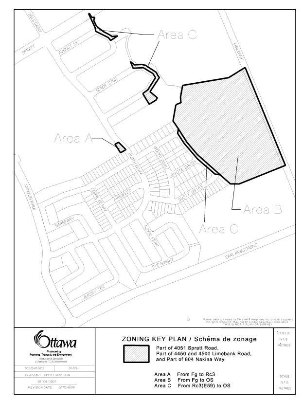
There are three parcels of land that are the subject of this Zoning By-law amendment application that are located in Riverside South – Phase 4. There is one small parcel of land in Phase 3 of Riverside South. Phases 3 and 4 are south of Spratt Road and Nakina Way, north of Earl Armstrong Road, east of North Bluff Drive and Canyon Walk Drive and west of Limebank Road. The sites are shown in Document 1.
Purpose of
Zoning Amendment
The purpose of the zoning changes requested is to recognize the stormwater facilities as part of Riverside South – Phase 4 and to process necessary technical zoning changes to update the zones within two registered subdivisions.
The lands that are the subject of this Zoning By-law amendment are zoned Future Growth, Fg and Special Mixed Residential (Exception 59), Rc3(E59).
The applicant wishes to bring the stormwater facility that services Riverside South – Phase 4 into the appropriate zone and to update the existing zoning in several locations to align with the registered subdivision plans.
DISCUSSION
The Official Plan places the subject lands in
the General Urban Area within the Airport Vicinity Development Zone. The General Urban Area designation
facilitates the development of complete and sustainable communities. The Airport Vicinity Development Zone
ensures that all development is to be protected from the effects of aircraft
noise.
The lands subject to this application form part
of Draft Approved and registered subdivision plans. All technical studies,
including the Noise Studies have been completed for these lands.
The proposed zoning changes are in keeping with
development that has already occurred within Riverside South. Staff supports this proposed Zoning By-law
amendment as it continues the orderly development of the Riverside South
community and follows through with several housekeeping zoning matters which
must be addressed (see Documents 2 and 3).
ENVIRONMENTAL IMPLICATIONS
The zoning of the stormwater pond and outlet to an ‘Open Space’ zone is in keeping with the City’s direction to have this type of infrastructure recognized as a green land use which is environmentally sensitive.
CONSULTATION
Notice of this application was carried out in accordance with the City's Public Notification and Consultation Policy. The Ward Councillor is aware of this application and the staff recommendation. The City did not receive any negative comments or opposition to this application.
FINANCIAL IMPLICATIONS
APPLICATION PROCESS TIMELINE
STATUS
This application was processed by the "On Time
Decision Date" established for the processing of Zoning By-law amendment
applications.
SUPPORTING DOCUMENTATION
Document 1 Location
Map
Document 2 Details
of Recommended Zoning
Document 3 Proposed
Zoning Map
DISPOSITION
City Clerk’s Branch, Secretariat Services to
notify the owner, Urbandale, Attention: Mary Jarvis, 2193 Arch Street, Ottawa,
Ontario K1G 3H5, applicant, Mary Jarvis, 2139 Arch Street, Ottawa, Ontario K1G
3H5, OttawaScene.com, 174 Colonnade Road, Unit #33, Ottawa, ON K2E 7J5,
Ghislain Lamarche, Program Manager, Assessment, Financial Services Branch (Mail
Code: 26‑76) of City Council’s
decision.
Planning, Transit and the Environment
Department to prepare the implementing by-law, forward to Legal Services Branch
and undertake the statutory notification.
Legal Services Branch to forward the
implementing by-law to City Council.
LOCATION MAP DOCUMENT
1

DETAILS OF RECOMMENDED ZONING DOCUMENT
2
The following changes are proposed to Zoning By-law 333 of 1999 of the former City of Gloucester:
1. The parcels of land that are part of 4051 Spratt Road, 4450 & 4500 Limebank Road, and 804 Nakina Way are to be rezoned as follows and Map 21D of Zoning By-law 333 of 1999 will be amended to reflect the changes as shown on Document 3:
Area A Fg, Future growth be rezoned to Rc3, Special Mixed Residential Dwelling
Area B Fg, Future growth be rezoned to OS, Open Space
Area C Rc3(E59) be rezoned to OS, Open Space
DETAILS OF RECOMMENDED ZONING DOCUMENT
3