Report
to/Rapport au :
Planning and Environment Committee
Comité de l'urbanisme et de
l'environnement
and Council / et au Conseil
11 June 2007 / le 11 June 2007
Submitted by/Soumis par : Nancy Schepers, Deputy City Manager/Directrice
municipale adjointe,
Planning, Transit and the Environment/Urbanisme, Transport en commun et
Environnement
Contact
Person/Personne ressource : Richard Kilstrom, Manager/Gestionnaire, Community
Planning and Design/Aménagement et conception communautaire, Planning
Branch/Direction de l’urbanisme
(613)
580-2424 x22653, richard.kilstrom@ottawa.ca
REPORT RECOMMENDATION
1. That
Planning and Environment Committee recommend City Council:
a) Approve the Richmond Road/Westboro Community Design Plan (distributed separately and on file with the City Clerk and shown as Document 2) as Council's direction on the future development of the area.
b) Approve an amendment to the former City of Ottawa Zoning By-law, 1998 as shown on the location maps and detailed in Document 3.
c) Rescind the January 25, 2006 City Council motion that all rezoning and Official Plan amendment requests for the Richmond Road/Westboro Community Design Plan study area be deferred until the completion and approval by Council of the Community Design Plan process.
2. That Planning and Environment Committee direct the Planning, Transit and the Environment Department to:
a) Initiate a transportation management implementation plan to examine in greater detail how the 40 per cent transit modal share target can be achieved in the Community Design Plan area and how the City and developers can implement the various measures proposed (including potential funding mechanisms).
b) Refer the Development Review Mechanism model discussed in the Richmond Road/Westboro Community Design Plan to the 2008 Official Plan Review's analysis of the interpretation and implementation of the City's intensification objectives.
RECOMMANDATION DU RAPPORT
1. Que le Comité de
l’urbanisme et de l’environnement recommande au Conseil :
a) D’approuver
le plan
de conception communautaire Chemin Richmond/Westboro
(distribué séparément et versé au dossier auprès du greffier de la Ville et
indiqué comme document 2), et que ce plan constitue l’orientation approuvée par
le Conseil pour tout aménagement futur du secteur.
b) D’approuver
la modification du règlement de zonage de l’ancienne Ville d’Ottawa, 1998,
selon les indications du plan d’emplacement et les détails précisés dans le
document 3.
c) D’annuler
la motion du 25 janvier 2006 du Conseil municipal demandant de reporter toute
demande de modification des règlements de zonage et du plan officiel jusqu’à la
fin du processus du plan de conception communautaire Chemin Richmond/Westboro
et son approbation par le Conseil.
2. Que le Comité de l’urbanisme et de
l’environnement demande au Service de l’urbanisme, du
transport en commun et de l’environnement :
a) De
préparer un plan de mise en œuvre de la gestion du transport afin d’examiner en
profondeur la façon dont on pourrait atteindre la cible de répartition modale du
transport en commun de 40 pour cent dans le secteur visé par le plan de
conception communautaire et la manière dont les promoteurs et la Ville
pourraient appliquer les diverses mesures proposées
(dont les mécanismes éventuels de financement).
b) Étudier
les mécanismes d’approbation d’un aménagement précisés dans le plan de conception
communautaire Chemin Richmond/Westboro en regard de
l’analyse de l’examen du plan officiel de 2008 quant à l’interprétation et à la
mise en œuvre des objectifs de la Ville en matière d’intensification.
EXECUTIVE SUMMARY
Assumptions and Analysis:
This report recommends approval of the Richmond Road/Westboro Community Design Plan (CDP) (Document 2) as Council's direction for the future development of the Richmond Road/Westboro area. It provides a basis for several Zoning By-law amendments detailed in Document 3 to implement the CDP recommendations.
The CDP's planning strategy provides a framework for change that will see Richmond Road/Westboro as it is today become the Richmond Road/Westboro of tomorrow. A unifying vision foresees an attractive and liveable urban community, based on "green" principles and featuring a wide mix of uses, enhanced green spaces, excellent transit service and well-designed development that will enhance the area's diversity and vibrancy. Compatible intensification will occur primarily on appropriate sites along Richmond Road and Scott Street, and adjacent to transitway stations, where Official Plan policy objectives related to compatible development can be met.
The CDP area currently contains about 5300 dwelling units. Full built-out under the existing zoning could add 3200 units, a potential 60 per cent increase. The CDP projects that close to 4000 new units could be built in the CDP area, which is a moderate increase from the existing zoning development potential.
The CDP also projects that the current mix of residential and commercial uses on the Mainstreets will continue, existing industrial uses will be replaced by residential/commercial mixed use and that the Westboro Transitway Station area provides an opportunity for increased office employment use.
The CDP proposes detailed building envelope and infill development guidelines derived from a broad-based assessment of the Westboro area to help achieve the Official Plan's compatibility principles for intensification in established neighbourhoods. Notwithstanding these principles, the Department recognizes that there may also be particular circumstances as a result of unique property conditions or development proposals, where a built form program different from that recommended in the CDP may be acceptable. Such situations will continue to be dealt with through site-specific development review processes which will consider the broad objectives on which the CDP is based, as well as applicable Official Plan policies, and, where appropriate, will include an amendment to the CDP for the area.
A greenspace network strategy is also proposed including improving pathway links to the Ottawa River corridor, enhancement of Byron Tramway Park and confirmation of the Rochester Field/Maplelawn and Atlantis-Selby sites as green space.
A transportation impact study was undertaken to examine the impact of full build-out under the existing zoning and the proposed CDP recommendations. The traffic generated by full build-out under the CDP proposals can be safely accommodated on the area road network. A fundamental concept of this would be very strong transit supportive measures and enhanced pedestrian/cycling facilities where applicable. The target is for a 40 per cent transit modal share (TMS) in the Richmond Road corridor by 2021, an increase from the existing Transportation Master Plan city-wide target of a 30 per cent TMS.
Financial Implications:
The Richmond Road/Westboro CDP contains several initiatives and studies that are follow-up measures to move forward the implementation of the Plan. When these initiatives and studies come forward in future work programs, each will have budget implications that will be addressed at that time.
Public Consultation/Input:
A summary of the public consultation program, including the comments received, is detailed in Document 4.
Hypothèses et analyse :
Dans ce rapport, on recommande
d’approuver le plan de conception communautaire Chemin Richmond/Westboro (PCC)
figurant au document 2, et que ce plan constitue l’orientation approuvée par le
Conseil pour tout aménagement futur du secteur. Il sert également de base à
plusieurs modifications des règlements de zonage, détaillées dans le document
3, afin de permettre la mise en œuvre des recommandations du pCC.
La stratégie de planification du PCC
constitue un cadre de changement grâce auquel le secteur Chemin
Richmond/Westboro pourra devenir le quartier Chemin Richmond/Westboro de
demain. La vision unificatrice proposée permettra de mettre en place une
collectivité urbaine attrayante et vivable, basée sur des principes «
écologiques » et offrant toutes sortes de possibilités, dont des espaces verts
améliorés, un excellent service de transport en commun et un aménagement bien
conçu pour améliorer la vitalité et la diversité du secteur. Des emplacements
appropriés, situés le long du chemin Richmond et de la rue Scott, à proximité
de stations du transitway, seront réservés pour une concentration résidentielle
compatible avec le quartier, dans la mesure où pourront être respectés les
objectifs politiques du plan officiel relatifs à la compatibilité des
aménagements.
Le secteur visé par le PCC contient
actuellement environ 5 300 unités d'habitation. En fin de projet, on
pourrait ajouter, avec le zonage actuel, 3 200 unités supplémentaires,
soit une hausse de 60 pour cent. Selon le PCC, on pourrait construire près de
4 000 nouvelles unités résidentielles dans le secteur du PCC, ce qui
constitue une hausse modérée par rapport au potentiel d'aménagement du zonage
actuel.
Toujours selon le PCC, la variété
actuelle d'utilisations résidentielles et commerciales sur les rues principales
se maintiendra, les utilisations industrielles existantes seront remplacées par
des utilisations polyvalentes résidentielles/commerciales et le secteur de la
station du transitway Westboro pourrait accueillir davantage d'utilisations
d'emploi administratif.
Le PCC propose une enveloppe de
construction détaillée et des lignes directrices applicables à l’aménagement
des terrains intercalaires, qui découlent d’une évaluation globale du secteur
Westboro, afin de respecter les principes de compatibilité du plan officiel
relatifs à l’intensification de la concentration résidentielle dans les
quartiers établis. Nonobstant ces principes, le Service reconnaît que, dans
certaines circonstances spéciales découlant de conditions foncières
particulières ou des propositions d’aménagement, il est possible d’accepter un
programme de construction différent de celui qui est recommandé dans le PCC. Ce
genre de situation continuera à être analysé dans le cadre du processus
d’approbation de l’aménagement des sites, qui prendra en compte les objectifs
généraux du PCC, ainsi que les politiques du plan officiel et, le cas échéant,
autorisera une modification du PCC du secteur.
On propose également une stratégie
des espaces verts avec amélioration des sentiers d’accès au couloir de la
rivière des Outaouais, du parc Byron Tramway et confirmation de la vocation
d’espace vert des sites de Rochester Field/Maplelawn et d’Atlantis-Selby.
On a entrepris une étude d’impact du
transport dans le cas de l’utilisation de tous les terrains à bâtir dans le
cadre des règlements de zonage actuels et en fonction des recommandations du
PCC. Le trafic engendré par la construction, sur tous les terrains, selon la
proposition du PCC, pourrait être absorbé en toute sécurité sur le réseau
routier du secteur. Le principe fondamental proposé ici est de prendre des
mesures très importantes de promotion du transport en commun et d’améliorer
l’infrastructure piétonnière/cyclable, le cas échéant. L'objectif de
répartition modale est de 40 pour cent dans le couloir du chemin Richmond d’ici
2021, une hausse par rapport à l'objectif actuel du Plan directeur des
transports pour l'ensemble de la ville, fixé à 30 pour cent.
Répercussions financières :
Le plan de conception communautaire
Chemin Richmond/Westboro mentionne plusieurs initiatives qui constituent des
mesures de suivi de sa mise en œuvre. Lorsque ces initiatives et ces études
apparaîtront dans le programme futur des travaux, elles seront assorties
d’implications financières qui devront être prises en compte à ce moment là.
Consultation publique/Commentaires :
Le document 4 propose un résumé du
programme de consultation publique, ainsi que les commentaires reçus
BACKGROUND
On June 28, 2005 Planning and Environment Committee approved the terms of reference for the Richmond Road/Westboro Community Design Plan (CDP). The planning study had been previously requested by the Committee in response to three development applications along Richmond Road. In addition, two Community Associations in the area requested that a CDP study be undertaken in order to have a plan in place to guide future development.
The goal of the study was to develop a broad and integrated 20-year vision for the Richmond Road/Westboro area in order to guide both private development and the undertaking of public works. Following the selection of an urban design consultant team headed by GGBB Consultants, the study commenced in September 2005 and was completed in April 2007. A transportation consultant (IBI Group) was also hired to undertake a transportation impact analysis of the CDP recommendations.
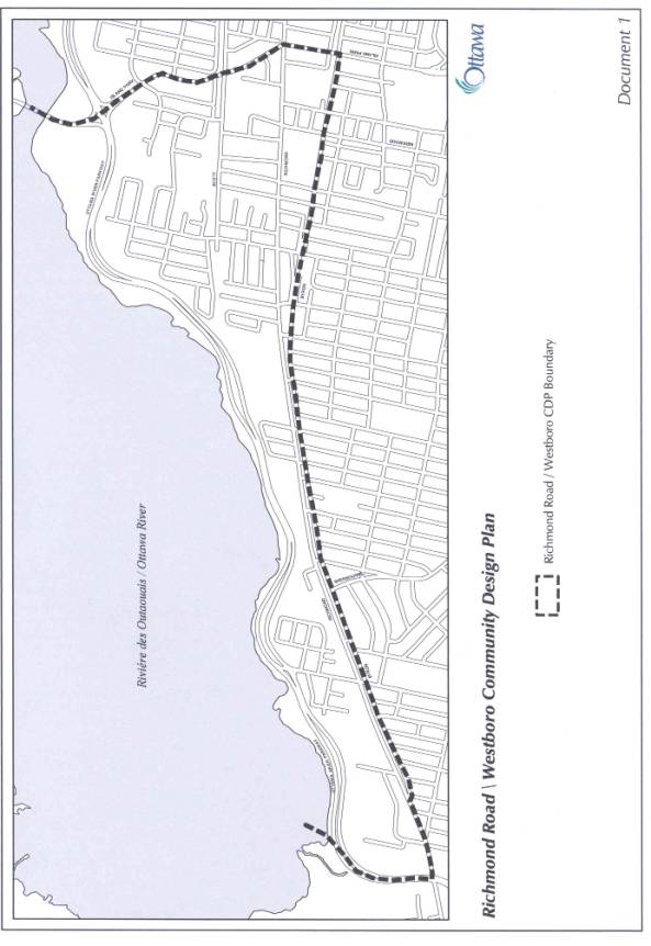
The CDP boundaries as shown on the Location Map (Document 1), include Island Park Drive on the east, the Ottawa River on the north, Ottawa River Parkway on the west and Byron Avenue on the south, an area of 2.7 square kilometres. Two Traditional Mainstreets, Richmond Road, running east-west along its entire length, and Scott Street, are included in the planning area. The CDP encompasses part of, or is bounded by, several neighbourhoods that are influenced by their proximity to Richmond Road, including Westboro, Westboro Beach, Hampton-Iona, Highland Park, McKellar Park, Woodroffe North and Woodpark. The large size of the planning area necessitated that it be divided into nine different sectors to address the planning issues of particular relevance to each sector.
DISCUSSION
Recommendation 1a) is to approve the CDP as Council's direction for the future development of the Richmond Road/Westboro area. It provides a basis for the Zoning By-law amendment detailed in Document 2 to implement the CDP recommendations related to built form and land use. While the CDP does set out specific provisions for zoning changes, its primary purpose is to guide City Council, staff, residents and property owners and developers in assessing the appropriateness of development proposals, including those development proposals where zoning changes are being requested to address a unique site condition or development program .
The CDP notes that it is the position of the Planning Advisory Committee (PAC) for the study that the CDP should be added to the Official Plan as a secondary plan. The Department does not support adding CDPs to the Official Plan at this time in order to avoid the situation where Council needs to adopt two similar amendments (to the Zoning By-law and to the secondary plan), when considering development applications, when one amendment would be sufficient. With respect to the Westboro CDP, development proposals may be submitted that are consistent with the spirit and direction of the CDP, but that may not be consistent with the specific built form direction provided in the CDP for the property in question. Staff consider it best to have these proposals considered through a Zoning By-law amendment process only, rather than also requiring an Official Plan Amendment. Where such rezoning proposals may be recommended for approval, an amendment to the property-specific direction set out in the CDP would also be recommended. Staff also note that, with Bill 51 being proclaimed on January 1st, 2007, Council-approved documents must be considered by the Ontario Municipal Board (OMB) in its decisions, meaning that the CDP will play a role at an OMB hearing whether it is a secondary plan or not. Finally, CDPs approved by Council to date have not been added to the Official Plan as new secondary plans. This issue will be examined in the 2008 Official Plan Review, as one of the "white paper" series that will be submitted to Committee and Council this autumn.
Planning Strategy
The CDP's planning strategy provides a framework for change that will see Richmond Road/Westboro as it is today become the Richmond Road/Westboro of tomorrow. A unifying vision foresees an attractive and liveable urban community, based on "green" principles and featuring a wide mix of uses, enhanced green spaces, excellent transit service and well-designed development that enhance the area's diversity and vibrancy. Compatible intensification will occur on appropriate mainstreet sites along Richmond Road and Scott Street, and adjacent to transitway stations, as directed by the Official Plan. This is not to say, however, that the compatibility polices of the OP may not also be able to be met on other properties which have uncommon site conditions or a unique development proposal. Such proposals will continue to be assessed through the process of site-specific Zoning By-law amendment applications which, if approved, could result in simultaneous amendments to the CDP for the property in question.
Building on the vision, three objectives for Richmond/Westboro govern the principles and directions set out in the CDP. These objectives are:
- Encourage intensification at appropriate locations that can achieve a human scale and is compatible with the existing residential community and the planned function for the site and/or area;
- Preserve, enhance and add to the green space network providing access to the Ottawa River and also serving local community needs;
- Define the distinct urban character of each sector of Richmond Road.
Based on the vision, objectives and accompanying principles, the CDP includes a greenspace network strategy and proposed streetscape improvements, a land use and appropriate building scale strategy, and building envelope guidelines and proposed zoning changes to help implement the CDP. It is also recognized that there may be site-specific circumstances or unique development proposals on particular sites where modifications to the CDP's specific built form and/or use directions applicable to the property in question are appropriate and remain consistent with the overall direction of the CDP and its underlying objectives. The CDP also features a 3D model to demonstrate what the area could look like in the future.
The CDP projects that close to 4000 new residential units could be built in the planning area, if full build-out of every property with redevelopment potential was to occur. This is a moderate increase from the approximately 3200 units representing full build-out under the existing zoning. Much of the potential increase in units is focused on existing industrially-zoned properties that do not presently permit residential uses, and on lands adjacent to the Westboro Transitway Station. Due to the size of these specific properties, and with no anticipated redevelopment proposals, the CDP is not recommending any zoning changes at this time. Rezoning applications at the time of future redevelopment proposals will provide an opportunity to examine individual site impacts in more detail, in keeping with the CDP directives. Zoning changes for properties elsewhere in the planning area are outlined in Document 3.
Building Envelope and Infill Development
Guidelines
The CDP sets out detailed building envelope and infill development guidelines on a broad basis to provide direction for achieving the Official Plan's compatibility principles for intensification in established neighbourhoods. The purpose of the first set of guidelines is to promote redevelopment that will reinforce the existing character of well-defined traditional mainstreet sections, such as Westboro Village and the developing mainstreet between Tweedsmuir and Island Park Drive. In addition, the guidelines aim to help create a renewed urban form in other sections of Richmond Road and along Scott Street. The second set of guidelines provides more specific guidance for infill development at key areas/sites in each of the planning area's nine sectors.
Greenspace
Network Strategy
Preserving, enhancing and extending existing green spaces was one of the top planning issues raised by the community. The CDP proposes a greenspace network strategy, with a key element being to improve pathway links to the Ottawa River Parkway corridor, which constitutes 80 per cent of the total green space in the planning area.
Other components include:
- A restored streetscape for Richmond Road/Byron Tramway Park. An extension westward of the existing recreational pathway from Redwood Avenue to Richardson Avenue is proposed to be included in the Community and Protective Services Department's 2008 Capital Works Program;
- Confirmation of the National Capital Commission's (NCC) Atlantis-Selby lands and Rochester Field/Maplelawn parcel as green space. The means by which these sites will be confirmed as green space is to be determined via discussions among the City, the NCC and affected Community Associations as an implementation measure of the CDP;
- Transformation of key local streets providing links to the Ottawa River Parkway corridor through tree planting, landscaping and the provision of minimum two-metre-sidewalks;
- Investment of cash-in-lieu of parkland funds generated by development toward the improvement of existing park and recreational facilities and creation of new parks in the planning area.
MAJOR ISSUES
Intensification,
Compatibility and Building Heights
Intensification on Richmond Road and other parts of the Planning Area was a contentious issue that emerged during the preparation in the CDP. Ottawa's Official Plan calls for intensification in the urban area over the next 20 years, with mainstreets such as Richmond Road and lands along the Transitway and in proximity to transitway stations being among the targeted areas for intensification. However, the Official Plan also recognizes that infill development has to be compatible with existing communities that are adjacent to mainstreets and the transitway, and must be consistent with the planned function for an area. Much discussion and debate centred on what could be considered compatible in terms of maximum building heights and form. Area residents wanted to keep building heights lower because of concerns about the impacts of intensification on their adjacent neighbourhoods--loss of privacy, shadowing, blocking of views, increase in traffic volumes, lack of infrastructure capacity and green spaces, overcrowded community facilities and schools, etc. Some developers and property owners proposed higher buildings, which they saw as implementing the City's intensification policies for mainstreets.
The CDP addresses these divergent views, in part through proposed changes to the existing zoning discussed under Recommendation 1b) below, and by establishing building envelope and infill development guidelines noted previously. In doing so, the Department recognizes that unique site conditions and development proposals may be brought forward in the future that are consistent with the overall direction of the CDP, but that may not fit within the specific details of the CDP related to built form and/or use on a particular site. When such proposals are received, they will be assessed on their merits as is required under the Planning Act, and in the context of the underlying principles and objectives of the CDP, as well as the broader-based policy directions set out in the OP which will continue to apply. Where a development proposal requiring a Zoning By-law amendment is deemed to be acceptable and appropriate, the CDP will be amended when appropriate to reflect the necessary site-specific modifications related to built form and/or land use.
Traffic
The transportation impact of intensification in the Planning Area was another major community issue to emerge during the study. A transportation impact study was undertaken to examine the impact of full build-out under the existing zoning and the proposed CDP recommendations. The following is a summary of the study findings:
· The traffic generated by full build-out under the CDP proposals can be safely accommodated on the area road network. A fundamental concept of this finding is very strong transit supportive measures and enhanced pedestrian facilities where applicable;
· It will not be necessary to widen Richmond Road to a four-lane arterial throughout the corridor as a result of the CDP recommendations;
· In order to provide higher Levels of Service (LOS) at key intersections, certain intersection modifications (additional turning lanes and tapers) would be required under the present transit modal share (TMS). At the preliminary design level, the modifications are feasible. However, with 40 per cent TMS in the corridor, these intersection modifications would not be required. This finding reinforces the importance of higher TMS to the City’s intensification goals, and as such, 40 per cent should become the City’s target for future transit use in this corridor, and be included in the review and update of the Transportation Master Plan in 2008.
This study is a new approach to transportation impact analysis and as outlined Document 3, there is some public scepticism that the 40 per cent target is realistic. Consequently, following Council approval of the CDP, the Department will initiate a transportation management implementation plan to examine in greater detail how the 40 per cent target can be achieved and how the City and developers can implement the various measures proposed, including their potential funding mechanisms. This plan should be included as part of the review and update of the TMP in 2008.
The measures that will need to be examined by this transportation management implementation plan include:
- Transit Priority Measures, such as queue jumps (which will require some roadway modifications), at key Richmond intersections (McEwen, New Orchard, Woodroffe, and Fraser (one exists now at Richmond/Golden), and signal priority at most intersections;
- Development of the New Orchard area transitway station, which is included in the TMP. It is also possible that additional stations in the corridor between Dominion Avenue and Lincoln Fields should be developed as well;
- An intensification of office employment uses in the Westboro Transitway Station area to encourage transit use by commuters;
· Enhancements to the pedestrian/cycling environment, including two-metre minimum sidewalks and improved connections to transitway stations. Such enhancements could occur at the time of road rehabilitation or reconstruction;
· Transportation Impact Assessments (TIA) prepared for new developments should propose physical, policy and planning measures that will improve the pedestrian/cycling environment and improve transit operations, as opposed to focusing on intersection modifications to increase vehicular capacity.
· The promotion of Transportation Demand Measures (TDM) as a component of new developments. TIA studies prepared for new developments should include an evaluation of the TMS at that time, as well as a TDM program to help reduce car usage. The City has an existing TDM program that has experienced reduced funding in recent years, and the Public Works and Services Department is in the process of preparing a report to Transportation Committee on this issue.
McKellar
Park/Highland Park/Westboro Area Traffic Management Plan Study
The McKellar Park/Highland Park/Westboro Area Traffic Management Plan is examining existing cut-through and other local traffic issues on the streets south of Richmond Road. A community concern, shared by the PAC, is that cut-through traffic will increase as a result of future intensification along Richmond Road. The PAC would have liked the CDP and the area traffic management study to have also examined and proposed measures to address such potential future increases.
With regard to broadening the scope of the McKellar Park Highland Park/ Westboro Area Traffic Management Plan, it is important to recognize that area traffic management is primarily an operational process intended to address existing traffic issues deemed to be of a significant nature (i.e., not easily resolved through an operational review) within neighbourhoods. The typical recommendations of these studies are various traffic management measures (usually in the form of traffic calming) that are both warranted given current conditions, and supported by the community given these conditions. Such measures, however, often have secondary impacts, especially for area residents. Attempting to consider future issues based on development potential that may or may not occur over the 20-year perspective of the CDP, and implement measures based on these, would likely be problematic for everyone involved. As well, the McKellar Park/Highland Park/Westboro Area Traffic Management Plan is already well underway, and broadening the scope would significantly delay the study, and lead to additional frustrations for many of the people involved and concerned about today’s problems.
Transportation Impact Assessments Guidelines, approved by Council in 2006, now require transportation impact assessment (TIA) studies, with varying degrees of complexity, as part of individual site plan application approvals above a certain size. The TIA evaluates, among other operational requirements, the potential for community impacts resulting from the proposed development, with a focus on the potential for neighbourhood infiltration by site-generated traffic.
Infrastructure
An analysis undertaken of the existing water, sanitary sewer and stormwater management infrastructure in the Planning Area concluded that the intensification proposed by the CDP can be serviced by existing City infrastructure, with a few exceptions that will require upgrading and/or minor extension at the time of redevelopment.
RECOMMENDATION 1b
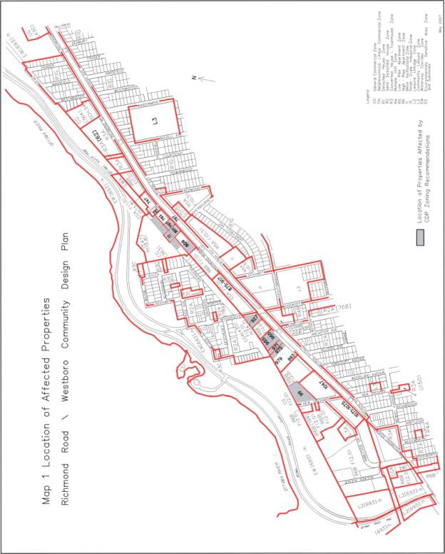
Recommendation 1b) is to approve an amendment to the former City of Ottawa Zoning By-law, 1998, as detailed in Document 3, to implement the zoning recommendations of the CDP. The CDP's zoning recommendations attempt to address both resident and developer concerns noted above in terms of the Official Plan's intensification and compatibility policies. However, this was done on a broader area-wide basis without any detailed site-specific or potential project analysis. The broad characteristics of each sector, the nature of the adjoining land use, and the general depth of lots were among the factors considered in developing the recommendations. In some cases the CDP proposes to reduce existing maximum building heights because of the potential impacts on the adjacent low-rise neighbourhood, such as the Woodroffe North area. The PAC reached consensus on the zoning and design for almost all of the key sites that are potential candidates for intensification. Part of that process included four PAC meetings with proponents for current or future development proposals on particular sites.
All owners whose properties would be affected by the CDP's zoning recommendations, if adopted by City Council, received a copy of the proposed zoning changes.
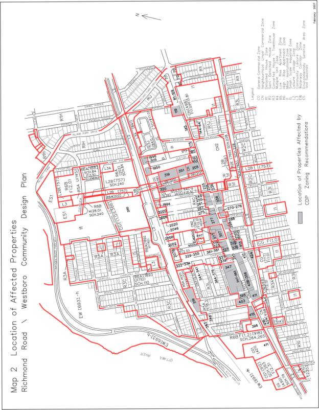
747
Richmond Road
Relative to 747 Richmond Road (see Map 1 in Document 3), consensus could not be reached among staff, nearby property owners, the PAC and the development proponent. The residents of 727 Richmond Road (a five- storey condominium immediately to the east) propose a maximum of six storeys as per the policies for Traditional Mainstreets. This position is supported by the PAC. The proponent has a rezoning application for a 19- and 21-storey condominium development that, according to the applicant, conforms to the City's intensification and compatibility policies, enhances the pedestrian environment, has limited impact on adjacent uses because of its relative isolation, and is in keeping with the nearby 15-storey height limit for 793 Richmond approved by Council and the OMB in 2005. Recently the proponent revised their application to a 15-storey height for the east half and a 18-storey height for the west half.
Staff considered both of the above positions, including the applicant’s recently revised position, in an attempt to develop a compromise recommendation for the CDP. That compromise was eight storeys on the east half of the site to relate to the adjacent five-storey condominium, and 12 storeys on the west half to relate to the approved 15-storey condominium proposal west across Cleary Avenue. This was not, however, acceptable to the community nor to the applicant, nor does staff consider it the best solution for this particular site with its unique context.
Staff’s view is that two narrow towers which leave a significant portion of the ground plane open for views to the Ottawa River Parkway and to the river itself from Richmond Road, is superior to a building of lesser height which fills the site and perpetuates the lack of views to the river that currently exists with the adjacent five-storey condominium, which covers well over 100 metres of its Richmond Road frontage.
It was therefore decided not to recommend a zoning change to 747 Richmond through the CDP process, but rather to bring forward a separate report, with a recommendation dealing specifically with the existing rezoning application submitted for this property, for consideration by Planning and Economic Development Committee (PEC) and Council. PEC and Council will also give consideration to any amendment to the CDP that would be required at the time that the rezoning for 747 Richmond is considered.
The issue that is central to the CDP discussion as reflected through the 747 Richmond Road proposal relates to attempting to achieve the different objectives of different stakeholder groups through CDPs. The Official Plan clearly states that CDPs should provide more detailed direction to advance the objectives of the OP related to intensification and compatibility, which in turn suggests a more policy-focused approach to CDPs. Communities experiencing development pressures, while recognizing the role of the CDP, then look to CDPs as a means to set in place detailed regulations and standards, which are achieved by incorporating zoning changes into the CDP. The development industry is seeking to ensure that CDPs provide clarity with respect to how Official Plan objectives will be advanced within the specific geographic areas where CDPs are to be prepared, and that these CDPs not be used as a means to undertake area-wide zoning changes. CDPs are intended to establish the manner in which Official Plan policies will be implemented at the community level for Mainstreets, Mixed-Use Centres, and Developing Communities; and, in the urban area, CDPs often recommend zoning amendments to reflect this additional level of detail. It is this level of detail that communities seek, and that is of concern to the development industry in those cases where the community maintains a view that there should be no site-specific zoning changes considered once a CDP is prepared.
Staff recognize that a CDP cannot ‘fine-tune” the zoning for every property in its area because almost every site has its own context and characteristics, and each site’s context and characteristics can change over time as properties are consolidated or severed, and as new development occurs nearby. Regardless of how a site receives its zoning—through the new Comprehensive Zoning By-law or via the implementation of a CDP—it is still possible that a development proponent, working within the unique context of a specific site, may propose a zoning amendment to accommodate a unique site context and/or an innovative alternative development proposal that was not, and could not be, foreseen when the existing zoning was established. Under the Planning Act, zoning amendment applications can be made at any time, including during or at the conclusion of a CDP. The Act requires that Council make a decision on each application based on its merits.
CDPs, as a planning process, have been in use since 2003, and have established a “track record” which can be evaluated in terms of what works well, what could be improved, and what needs more attention. The Official Plan Review’s “white paper” process provides this opportunity. The “white paper” process, by engaging all stakeholders, can facilitate this evaluation. One of the white papers to be developed will deal specifically with the foregoing discussion related to CDPs. It is expected through this process that greater clarity will be established on the role and structure of CDPs.
RECOMMENDATION 1c)
On January 25, 2006 Council passed a motion that all rezoning and Official Plan amendment requests for the Richmond Road/Westboro CDP study area be deferred until the completion and approval by Council of the CDP process. As that process is completed by the approval of this report, this motion can now be rescinded.
RECOMMENDATION 2a)
Recommendation 2a) asks Committee to direct this Department to undertake a transportation management implementation plan as discussed previously under Recommendation 1a), Major Issues.
RECOMMENDATION 2b)
During the preparation of the CDP, the PAC proposed that "density caps" and "triggers" were needed to monitor intensification in Richmond Road/Westboro on an on-going basis. They felt that a development monitoring/review mechanism was necessary to determine if intensification was having a negative impact on the community (e.g., impact on traffic and infrastructure capacities, level of cut-through traffic, the transit modal split, among others). At a certain percentage increase in the number of residential units in the overall CDP area or sub-area, a review mechanism of these impacts would be triggered to determine if the CDP's maximum development potential projections needed to be adjusted, the zoning amended accordingly, and/or future community infrastructure/facility needs addressed. Note that the Richmond Road/Westboro CDP study examined transportation and infrastructure capacities in terms of the CDP's and the existing zoning's maximum growth potential projections, and these matters are addressed in the CDP.
This issue is not unique to the Richmond Road/Westboro area. It has been raised in other CDP studies, and was most recently dealt with, on October 24, 2006, by Planning and Environment Committee in the report on the Queensway Terrace North Interim Control By-law study (ACS2006-PGM-POL-0069). The Committee directed staff to consider the Development Review Mechanism model, proposed by the Queensway Terrace North Public Advisory Committee, as part of addressing the interpretation and implementation of the City's intensification objectives during the five-year review of the Official Plan in 2008. The establishment of a development review mechanism to monitor the impacts of intensification on established neighbourhoods is a city-wide issue and is better addressed on a city-wide basis. The Richmond Road/Westboro CDP area should also be included in the Official Plan review of intensification objectives.
ENVIRONMENTAL IMPLICATIONS
Implementation
of the Richmond Road/Westboro CDP will help enhance the planning area for
residents, shoppers and visitors alike.
It will lead to future streetscape improvements, enhance the pedestrian
environment, confirm green spaces for recreational activities, establish green
links to the Ottawa River corridor, and provide design guidance to address
local microclimate conditions potentially affected by future development.
CONSULTATION
The Richmond Road/Westboro CDP entailed an extensive and detailed public consultation program. This program facilitated a creative process that saw initial ideas discussed, refined and incorporated into the recommendations as the study progressed, so that the CDP being recommended for approval, with the few exceptions discussed in this report and the CDP, represents the community's planning vision for Richmond Road/Westboro.
A
summary of the public consultation program, including the comments received
from the NCC to date, is detailed in Document 4
FINANCIAL IMPLICATIONS
The Richmond Road/Westboro CDP contains several initiatives and studies that are follow-up measures to move forward the implementation of the Plan. When these initiatives and studies come forward in future work programs, each will have budget implications that will be addressed at that time.
SUPPORTING DOCUMENTATION
Document 2 Richmond Road/Westboro CDP (on file with the City Clerk and distributed separately).
Document 3 List of Zoning Bylaw Changes and Location Maps
Document 4 Consultation Details
DISPOSITION
Planning,
Transit and the Environment Department, Planning Branch to:
·
Undertake the follow-up implementation measures
outlined in the CDP that are its responsibility;
·
Notify the Community and Protective Services Department
of Council's decision regarding the CDP recommendations, including: adding the
extension of the Byron Tramway Park pathway from Redwood Avenue to Richardson
Avenue to their 2007 Capital Works Program; confirming Atlantis-Selby and Rochester
Field as greenspace; directing cash-in-lieu of parkland funds generated within
the CDP area remain in the CDP area; and, examining the programming of
Churchill Seniors Centre as there is some potential to increase capacity, with
the caveat that parking is a major issue at the centre.
·
Prepare implementing by-laws;
·
Notify persons who made oral or written submissions at
Planning and Environment Committee and all persons and public bodies who
requested to be notified of the amendments;
·
Advertise the adoption of the amending Zoning By-laws.
Legal Services to forward implementing by-laws to
City Council.
LOCATION MAP DOCUMENT
1
LIST OF ZONING BYLAW CHANGES AND LOCATION MAPS DOCUMENT 3
LIST OF ZONING BY-LAW CHANGES INCLUDING ZONING MAPS
|
Address |
Existing Zoning |
Proposed Zoning |
|
99 New Orchard |
CG F(2.0) General Commercial Zone |
CG F(2.0) H(25) Increase height limit from 18 to 25 m. |
|
975 Richmond |
CG4 [435] F(2.0) H (24.7) |
CG4 [435] F(1.0) H(15) Decrease the height limit from 24.7 m to 15 m. and FSI from 2.0 to 1.0. |
|
971 Richmond |
CG4 F(2.0) H(24.7) |
CG4 F(1.0) H(15) Decrease the height limit from 24.7 m to 15 m. and FSI from 2.0 to 1.0. |
|
955-65, 927 Richmond 108 Woodroffe |
CG4 [435] F(2.0) H(24.7) |
CG4 [435] F(1.0) H(15) Decrease the height limit from 24.7 m to 15 m and FSI from 2.0 to 1.0 |
|
809 Richmond |
CG [362] |
West half of property - CG[362]H (15) Decrease the height limit from 18 m to 15 m. East half – no change |
|
797 Richmond |
CG4 F(1.0) H(13.8) |
CG4 F(2.0) H (18) Increase the height limit from 13.8 m to 18 m and FSI from 1.0 to 2.0. |
|
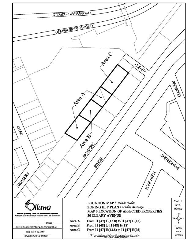
Part of 30 Cleary |
I1 [47] H (13.8); I1[48] Minor Institutional Zone |
I1 [47] [48] H (18 and 25) Increase the height limit from 13.8 m to 15 and 18 m for part of 30 Cleary Avenue as shown on Map 3. |
|
415 Richmond |
CN2 [507] F(2.0) H (24) Neighbourhood Linear Commercial Zone |
CN2 [507] F(1.0) H (15) Decrease the height limit from 24m to 15m and the FSI from 2.0 to 1.0. |
|
403 Richmond |
CN2 [507] F(2.0) H (24) |
CN2 [507] F(2.0) H (18) Decrease height limit to 18 m |
|
Address |
Existing Zoning |
Proposed Zoning |
|
395 Richmond |
CN2 [507] F(2.0) H (24) |
CN2 [507] F(1.0) H (15) Decrease the height limit from 24 m to 15 m and the FSI from 2.0 to 1.0 |
|
Front half of 358-382 Richmond; Front half of 408 Churchill; 356, 386-390 Richmond; 411 Roosevelt; 352 Danforth; 424 Churchill |
CN2 [507] F(2.0) H (24) |
CN2 [507] F(2.0) H (18) Decrease the height limit from 24 m to 18 m |
|
337-339 Richmond; 347-383 Richmond; 393-99 Winston; 376 Madison |
CN2 [507] F(2.0) H (24) |
CN2 [507] F(2.0) H (18) Decrease the height limit from 24 m to 18 m. |
|
322-32 Richmond; 413 Churchill |
CN2 [507] F(2.0) H (24) |
CN2 [507] F(2.0) H (18) Decrease the height limit from 24 m to 18 m. |
|
319-27; 300-318 Richmond |
CN2 [507] F(2.0) H (24) |
CN2 [507] F(1.0) H (15) Decrease the height limit from 24 m to 15 m and the FSI from 2.0 to 1.0 |
|
277 Richmond 307 and 307A Richmond; |
CN2 [507] F(2.0) H (24) CN2[508] F(2.0) H (24) |
CN2 [507] F(2.0) H (18) CN2 [508] F(2.0) H (18) Decrease the height limit from 24 m to 18 m |
|
377 and 81 Winona |
CN2 [507] F(2.0) H (24) |
CN2 [507] F(2.0) H (18) Decrease the height limit from 24 m to 18 m. |
|
267-75; 288-98; 270-74 Richmond 396 Athlone |
CN2 [507] F(2.0) H (24) |
CN2 [507] F(1.0) H (15) Decrease the height limit from 24 m to 15 m and the FSI from 2.0 to 1.0 |
|
276 Richmond |
CN2 [775] F(2.0) H (24) |
CN2 [775] F(1.0) H (15) Decrease the height limit from 24 m to 15 m and the FSI from 2.0 to 1.0 |
|
256 Richmond; 401 Athlone; 406 Tweedsmuir |
CN2 [507] F(2.0) H (24) |
CN2 [507] F(2.0) H (18) Decrease the height limit from 24 to 18 m |
|
249-61 Richmond |
CN2 [507] F(2.0) H (24) |
CN2 [507] F(1.0) H (15) Decrease the height limit from 24 m to 15 m and the FSI from 2.0 to 1.0 |
|
Address |
Existing Zoning |
Proposed Zoning |
|
205 Richmond |
CN [640] H (15) |
CN [640] H (18) Increase the height limit from 15 m to 18 m. |
|
119 Richmond |
CN [498] F(1.0) H (13.8) |
CN [498] F(2.0) H (18) Increase the height limit from 13.8 m to 18 m and the FSI from 1.0 to 2.0 |
|
1946-50 Scott 305 Clifton |
R5A H (18) Residential Low-Rise Apartment Zone |
R5A H (18) Add Apartment building high-rise as a permitted use. |
|
335, 342-46 Roosevelt |
R5A H (18.3) |
R5A H (18.3) Add Apartment building high-rise as a permitted use. |
|
351 McRae |
IS [631 H (15) Small-Scale Industrial Zone |
Change zoning to CG H (15) Maximum Height within 20 m of a residential zone - 11 m In all other cases - 15 m |
|
319 McRae |
IS F(1.0) |
Change zoning to CG F(1.0) Maximum Height within 20 m of a residential zone - 11 m In all other cases - 18 m |
|
320-344 McRae |
IS [631] H (15) |
Change zoning to CG H (15) |
CONSULTATION
DETAILS DOCUMENT
4
The
Richmond Road/Westboro CDP had an extensive public consultation program ,
including the following components:
Open Houses
The City also sponsored three open house and presentation/comment sessions for the Richmond Road/Westboro CDP, as follows:
· Joint Public Open House (Issue Identification) with the Richmond Road Widening Environmental Assessment and the McKellar Park/Highland Park/Westboro Area Traffic Management Study - Monday, November 29, 2005 - Attendance in excess of 500.
· Workshop and Public Open House - Preliminary Vision, April 3, 2006 - Attendance in excess of 300.
· Public Open House - Draft CDP, March 22, 2007 - Attendance in excess of 200.
Planning Advisory Committee
A major part of the consultation process involved a Planning Advisory Committee (PAC), which had representatives from the Community Associations in the study area, the Westboro BIA, the NCC and the two Ward Councillors' offices. The PAC met 14 times throughout the study period and provided planning advice to the study team, commented on draft documents, and heard guest speakers representing area developers.
The PAC supports approval of the CDP by City Council to guide development with the following caveats:
- The 2008 Official Plan and supporting Master Plans review results are needed to provide more information and guidance on lower than anticipated population growth rates, rapid transit routes, what intensification means for communities, and provision for a development review mechanism to evaluate growth;
- The McKellar Park/Highland Park/Westboro Area Traffic Study boundaries have not included the Woodpark and Woodroffe North neighbourhoods, leaving them potentially vulnerable to traffic impacts;
- Neither the CDP transportation impact study nor the area traffic study addressed the issue of potential increases in cut-through traffic resulting from intensification;
- The feasibility of achieving a 40 per cent TMS and the impacts on the community if it is not achieved;
- Infrastructure capacity may not be sufficient to accommodate intensification;
- Need for more stringent building spacing guidelines/provisions than proposed in the CDP.
The PAC would like the CDP revisited if the additional information based on the above caveats becomes available and suggests that the CDP policies needs to be augmented to provide additional guidance to ensure compatible development that minimizes negative impacts on the community.
Staff Response
This report and the CDP have responded to the caveats as follows:
- Lower growth rates means that it may take a few additional years to approach full build-out in the community. Should the Official Plan review recommend a development review mechanism, it will be applied city-wide without having to revisit this and every existing CDP. A better understanding of what intensification means for each community would be desirable for the preparation of future CDPs;
- This report outlined the issues with expanding the scope of the existing area traffic management study. The CDP also notes that TIAs prepared for individual site applications now have to demonstrate the potential for community impacts resulting from the proposed development, with a focus on the potential for neighbourhood infiltration by site-generated traffic. If an additional traffic study is deemed by Council to be required, it would need to be added to a future work program;
- This report asks Committee to direct staff to undertake a transportation management implementation plan to examine in greater detail how the 40 per cent TMS can be achieved;
- The infrastructure capacity analysis prepared for the CDP concluded that intensification proposed can be serviced by the existing infrastructure, with a few exceptions that will require upgrading and minor extensions;
- More stringent building spacing guidelines than proposed in the CDP would make it difficult to appropriately design buildings between four and 14 storeys.
This Department is of the view that the CDP and its implementation recommendations adequately addressed the caveats raised by the PAC. Should new unanticipated information come to light that suggests the CDP policies may need to be augmented, then the need for such an exercise can be addressed at that time.
NCC Comments
The NCC provided the following comments on the draft CDP:
- Our comments should be incorporated into the CDP similar to other diverse views noted on individual properties.
- In order to avoid an adversarial position in relation to the Pac’s on greenspace retention, the NCC decided to await the outcome of the study process before providing comments on the draft CDP. We disagree with the wording in the CDP regarding Rochester Field and Atlantis -Selby as it does not reflect the NCC position on these lands. We do not support any wording for local park or city-wide references. The CDP also needs to note the existing federal ownership and authority for land use planning of these sites and that the NCC is preparing an Urban Lands Master Plan for federal lands within the urban area.
- Map 3 – Existing Conditions. Suggest legend wording state “Park and/or open space ", as not all open space is park.
- The suggestion of municipal sports fields on Rochester Field, as it is presently still under OMB appeal, is not appropriate.
- The City will need to formalize an implementation strategy to achieve a 40 per cent TMS target.
- The following lines in the CDP should be rephrased: "determine the means by which Atlantis-Selby will be preserved"; "Atlantis-Selby and Rochester Field as confirmed green space"; and, "All of the Rochester Field parcel be retained as green space”.
- The following is the propose rephrasing: "Working with the NCC to preserve holdings at Atlantis-Selby as green space"; "Continued discussions as to the overall open space context of these lands"; "On-going participation in any implementation measures for these lands in the CDP and/or any NCC Planning Documents"; "As much as possible of Rochester Field should be retained as green space"; and, "Open discussions with the NCC should be continued to preserve as much open space as possible".
- Map 8 - It is premature to indicate Rochester Field and Atlantis-Selby in a separate colour as a unique "Confirmed Greenspace" designation. They should be the same colour as the ORP and listed as federally-owned. There seems little justification to single out these sites.
- The CDP be incorporated into the Official Plan as a secondary plan.
Staff Response
- Factual changes requested by the NCC have been incorporated into the CDP. NCC’s positions, where they differ from the CDP, are addressed in this section of the staff report, as they came very late in the study process and did not form part of the general public discussion, as was the case for other sites discussed in the CDP.
- Staff and the PAC tried to engage the NCC in discussions regarding the future of Rochester Field and Atlantis-Selby during the study process. The NCC chose not bring any position to the table. Without an NCC position, the CDP responded to the community's greenspace concerns and the existing deficiency of City parkland in Ottawa West, as outlined in Section 3.4 of the CDP. The CDP has been revised to note the NCC’s federal land use planning role and the Urban Lands Master Plan.
- Map 3 legend reference is to park and open space green areas in general and a legend change is not necessary. Separate categories are detailed in subsequent maps dealing with the open space network.
- The CDP quotes the Study of Potential Sportsfield Sites prepared for the City and received by the then Health, Recreation and Social Services Committee in 2006. This study identified Rochester Field as a potential future sports field site.
- The CDP and this report include a recommendation for a transportation management implementation study.
- The revised wording regarding the status of Atlantis-Selby and Rochester Field weakens the CDP position, established during the CDP study public consultation process, that these sites be confirmed as greenspace. The CDP text was revised to note the NCC's ownership and federal authority for land use planning of these sites.
- Map 8 - The separate colour of Atlantis-Selby and Rochester Field as confirmed greenspace reflects the CDP recommendations noted previously. “Confirmed Greenspace” on Map 8 is not a land use designation, but a graphic representation of the CDP recommendation. Federal ownership is noted in the text.
- It is the position of this Department that CDPs not be included in the Official Plan as Secondary Plans as discussed in the report, although the issue will be re-examined as part of the 2008 Official Plan review.
Environmental Advisory Committee
The Environmental Advisory Committee provided the following comments:
- It is very important to improve access to the Ottawa River Parkway. This suggests that it may well be advisable to consider additional measures to achieve this goal.
- More can and should be done to green, and enhance the aesthetic features of, the Byron Tramway linear park - particularly west of Roosevelt.
- The landscaping plan should include ample tree wells to help green the main streets and to ensure that the trees don't die prematurely.
- The densification provided for in the plan highlights the need to ensure that: Parkettes are developed adjacent to the multi-story buildings in order to provide relief from endless pavement and concrete structures; steps are taken to manage the additional stormwater runoff locally and to the extent possible use this runoff to water the greenspace rather than letting it flow into the sewers; and, the financial gains to the City of densification are shared equitably with the impacted communities to guarantee that the public funds are available to green the streets and Tramway, manage stormwater runoff locally, and to improve significantly access to the Ottawa River Parkway.
Staff Response
- The CDP identifies additional pedestrian/cycling connections to the Ottawa River as part of "Green Streets and recommends that the City undertake steps to create such connections as an implementation measure of the CDP.
- The CDP recommends that Byron Tramway Park landscaping be enhanced with new trees and shrubs, and as part of the 2008 Capital Works budget, the pathway be extended from Redwood to Richmond.
- The CDP recommends, as an implementation measure, a streetscaping review of the Westboro Village and East Village areas and a streetscaping plan of Richmond west of Golden, as well as Churchill, Scott and McRae. These reviews and plans will provide an opportunity to identify appropriate locations for street trees and means of planting to ensure their better survival.
- The CDP includes the following to address the impacts of intensification: Guidelines promoting enhanced landscaping of development sites, which would be implemented at the site plan approval stage; on-site attenuation of stormwater runoff for major storms, as has been the practice in the City for many years; and, a recommendation that parkland dedication resulting from development be directed to the CDP area. The timing of other implementation measures will be determined as part of future budget deliberations.
Ottawa Forests and Greenspace Advisory Committee
The Ottawa Forests and Greenspace Advisory Committee commented that the City is encouraged to find small pockets of greenspace in this area and to work to have these areas zoned so that trees may be planted to enhance the streetscape.
Staff Response
The streetscaping plans referred to above will examine opportunities for small pockets of greenspace for additional tree planting.
The following table summarizes the public comments received based on the draft Richmond Road/Westboro CDP presented at the March 22, 2007 Open House and circulated for comments.
|
Summary of 31 Comment Sheets from March 22,
2007 Open House |
||
Comment
|
No. |
Planning Response |
|
Concern the traffic study did not address cut-through traffic and increased speeds on streets to the south of Richmond, particularly on Golden and Roosevelt, with the development of the Westboro Station property. This is a major gap in the study. Concern that the Woodpark, Woodroffe North community not included in the area traffic management study. Create barriers blocking entry from Golden and Roosevelt to Byron. Control increased traffic from intensification by substantial traffic calming measures. Learn from the Glebe on how it addressed cut-though traffic and successes and problems on Bank St. |
10 |
The CDP discusses how the existing cut-through traffic and other traffic issues will be addressed by the area traffic management study underway. Too severe traffic calming measures would be of considerable inconvenience to local residents and would not likely be acceptable. One of the objectives of the CDP is to promote an urban environment where the need for car travel will be reduced. The McKellar Park/Highland Park/ Westboro Area Traffic Management Study is examining existing traffic issues on streets such as Golden and Roosevelt and will consider previous studies such as the one in the Glebe. |
|
Will traffic calming and/or increased enforcement of travel speeds along Byron Avenue be considered and plans implemented once higher density housing plans are underway? Concerned with traffic cutting through McKellar Park along Sherbourne Avenue. |
2 |
The area traffic management study is addressing existing traffic problems in this area, including Byron Avenue and Sherbourne Avenue. |
|
Concern with heavy traffic on Island Park Drive. |
1 |
The CDP’s traffic impact study noted the heavy traffic on Island Park Drive. The Richmond/IPD intersection is closely correlated with traffic movements using the Champlain Bridge. Increased capacity of inter-provincial traffic is currently being studied as part of the Inter-Provincial Bridge Crossings study. |
|
CDP proposes a realistic shift to transit use. Concern about achieving 40 per cent transit modal share (TMS) target when development is happening in advance. - CDP should have included an overall plan to stimulate increased use of transit in the study area. Increasing non-auto modes will be difficult. An addition of almost 4000 units is a 32 per cent increase from the existing dwellings in the CDP and surrounding neighbourhoods-given transportation issues (and other infrastructure problems) this appears excessive without properly defined solutions. Concern about proposed development around Cleary/Richmond – 747 Richmond, 793 Richmond Unitarian House will cause increased traffic delays on Richmond because of modifications at the Cleary intersection. |
6 |
Community recognition that a shift to transit is necessary in order to avoid increasing traffic congestion, intersection widenings and additional turning lanes. The CDP sets out a comprehensive program and a 40 per cent TMS target (transit priority measures, pedestrian/cycle enhancements, transportation demand management measures) to help increase transit use and avoid intersection modifications. A follow-up to the CDP will be the preparation of a transportation management implementation plan to determine in greater detail how the 40 per cent target can be achieved and how the City and developers can implement the various measures proposed in the CDP, including potential funding mechanisms. Although a 40 per cent target can only be achieved over time, new infill developments will also come on stream over a number of years rather than all at once. The Woodroffe and Cleary intersections with Richmond Road will be part of this implementation plan. |
|
A more comprehensive area traffic management study should be done, including areas along Richmond to the Ottawa River Parkway. If the traffic issue is to be addressed effectively the City will have to determine where it is coming from – local or pass-through. |
3 |
The transportation impact study included the area up to the Ottawa
River Parkway. This report and the CDP note that expanding the scope of the study would mean further delays in its completion. Whether traffic is local
or pass-though, it contributes to roadway traffic volumes, so needed
additional information would not be obtained by gathering such data. |
|
Intensification should only be allowed if the existing roadway infrastructure could support it – Opposed to any turning lanes at Woodroffe. |
1 |
The recommendations for the Woodroffe/Richmond area are for a reduction in maximum building heights and the potential level of intensification permitted under the existing zoning. Achieving a 40 per cent
TMS will avoid the need for turning lanes at Woodroffe. |
|
Concerned with traffic between Churchill and Golden. Reduce speed limits on Richmond from 50 to 40 km/hr between Golden and McRae to reduce accident risk. |
1 1 |
The matter of the level of a speed limit on a particular road is always a controversial issue, especially among residents, and by far, the typical request is to reduce the limit in the perception the change will improve overall safety. In this particular case, the Traffic Management Division has not received any speed related requests for the Westboro Village area of Richmond Road over the past 18 years. They will conduct a couple of spot speed surveys to determine the level of free flow speeds east and west of Churchill Avenue to determine if a full speed zone review should be undertaken. |
|
Concerned with development at Island Park Drive/Richmond intersection and increasing traffic congestion. |
1 |
The CDP transportation impact study recommended transit modal share target of 40 per cent to help address increasing traffic congestion. |
|
We need traffic lights at Berkley and Richmond. |
1 |
Problem of adjacent traffic lights at Golden and Roosevelt. Ward Councillor investigating this issue. |
|
Intensification identified in CDP is not overwhelming. |
3 |
This indicates broad support for the planning approach. |
|
Cannot understand proposing a riverbank congested with high–rise towers – should not be any in this neighbourhood. Vision is for a wall/string of apartment buildings along Richmond. Road. Issue of spacing of buildings and increased setbacks on all sides above the three storey level for light and air |
1 1 1 |
Then CDP recommends that high-rise towers be limited to a few key locations, such as the Westboro Area Transitway station. Vision is for mixed-use infill development, with guidelines of setbacks above the third storey from the side yards and above the fourth storey for the rear and front yards (as per the draft TM-Traditional Mainstreet provisions) to avoid creating a “wall” effect and provide light and air. |
|
Analysis of impacts of existing infrastructure, costs of improvements and market conditions analysis would be done in more sensitive established neighbourhoods as they are done for Greenfield CDPs. |
1 |
A transportation impact analysis and an infrastructure capacity analysis were done for the Westboro CDP. The City does not do market conditions analysis for established neighbourhood area CDPs. |
|
Challenge the need for a series of high density buildings in the planning area since it is now known that modest densification will satisfy current demographic projections |
1 |
The CDP proposed a moderate level of intensification in keeping with the Official Plan’s intensification and compatibility policies. |
|
Concerned with “Green Street” proposal will lose our front lawns and have already too heavy traffic and parked cars closer to our homes. How can it be a Green Street with the pending sale of City- owned parkland now at end of Berkley for development? |
1 |
The implementation of a “Green Street” concept will require detailed study of each designated street. Staff would work closely with the affected residents to develop a mutually acceptable plan. Loss of front lawns would not be contemplated in the development of a Green Street plan. The City-owned lots at the end of Berkley/Dominion are not parkland and the Green Street concept is not dependent on their current condition being retained. These lots are zoned R3L-Residential Converted House/Townhouse. |
|
Proceed with Lanark Street improvements as soon as possible. |
1 |
Construction is tentatively scheduled to begin mid-May 2007 with a completion date of mid-September 2007 |
|
City should relocate the store at NW corner of Richmond/Woodroffe a few metres west to eliminate impaired vision at that intersection that has many accidents. |
1 |
Should the store site be developed, this issue would be addressed at site plan control approval. |
|
Increasing population/shops will need sufficient parking. Need to avoid on-street parking. |
1 |
New developments are required to provide on-site parking. The City is also considering a public parking area as part of the Bourk site development to serve Westboro Village. |
|
Concerned with cash-in-lieu of parking granted to the Exchange |
1 |
The developer paid the full amount that the City charges for cash-in-lieu of parking, which will go into the fund for a future public parking area in the Westboro Village area. It is expected that the City’s existing cash-in-lieu policy will be reviewed in the near future. |
|
Bicycle transportation should be considered as part of the City’s overall transit strategy. Support improved pedestrian and cycle access around Westboro. Like proposed westward extension of Byron Tramway Park to provide a safe walking path. |
2 1 |
The draft CDP was revised to increase the emphasis placed on bicycle transportation. An important principle of the CDP. |
|
Like continuous storefronts along Richmond/Scott and to remove unsightly parking lots and other non-pedestrian friendly areas |
1 |
This is a fundamental principle of the CDP. |
|
Support preservation of green space (Atlantis-Selby) - must be confirmed. |
5 |
CDP recommends confirmation of the preservation of this greenspace. |
|
Additional greenspace, community parks should also be a priority (e.g., small urban play parks near high density condos) and linkages to the Ottawa River. Would like to see soccer fields. Concern about total green space available after intensification –where will the parks be developed to accommodate growth. The City should find small pockets of greenspace in this area and work to have these areas zoned so that trees may be planted to enhance the streetscape. Should be consideration of forest management and an effort to enhance the quality of trees in our existing greenspaces. |
10 |
CDP recommends that parkland dedication (either in land or cash-in-lieu) be directed to the planning area. CDP notes that Rochester Field is identified as a potential sports field location by the City sports field study. The CDP recommends that Rochester Field and Atlantis-Selby be confirmed as green spaces and not lost to development. The City’s Forestry Division has existing programs in place addressing this concern. |
|
Like “Green Streets” idea but want to know more. |
1 |
The “Green Streets” concept and application to specific streets in the planning area is a follow-up implementation measure of the CDP. |
|
Shift to a finer grain of analysis and design. |
1 |
The CDP contains several implementation measures for more detailed studies, such as streetscaping plans of Richmond/Scott and examination of the Green Streets concept. |
|
Minimize through traffic in Sector 8/ Lanark Avenue. Do not like the intensification of 250 Lanark/former CBC building too big for Lanark neighbourhood, will block sun. |
1 1 |
The CDP identifies the former CBC site located adjacent to the Westboro Transitway station as an excellent opportunity for intensification, but requires that a site-specific traffic impact study be undertaken at the time of a rezoning and site plan application to address impacts on the road network. Sun/shadow study would also be required. The CDP proposes a transition in building height from a maximum of 12 storeys adjacent to the transitway station down to 6 storeys facing Lanark. |
|
Continue Westboro Village mainstreet to the west via a gradual change between a mainstreet and a series of private/public low scale amenities. |
1 |
CDP recommends this for Sectors 1-4, including preservation of Rochester Field as green space. |
|
Would like to see more restaurants and pubs in Westboro Village and fruit and vegetable stands. |
1 |
All these uses are permitted in Westboro Village. |
|
Need a good recreation centre – Redevelop the Jules Leger Centre. |
1 |
The Council-approved Community Infrastructure study determined that recreation/community centres even with intensification adequately serve the planning area. The Jules Leger is a provincial school for those with learning disabilities and will not likely be redeveloped. |
|
Scott St. is a disaster – get rid of used car lots and should be forced to move. |
1 |
CDP proposes the redevelopment of Scott as a traditional mainstreet. Used car lots are not a permitted use under the draft Traditional Mainstreet zoning and it is expected that they will eventually be redeveloped. |
|
Should have more employment/office type uses shown on the Plan so people can work closer to where they live. |
1 |
The CDP proposes residential mixed use on the Traditional Mainstreets, with a particular emphasis on employment uses (e.g., offices) near the Westboro Transitway Station and on McRae/Churchill. Employment uses can also locate along Richmond and Scott. Residential mixed use was assumed on the Traditional Mainstreets in order to determine the maximum residential unit count that could be achieved in the Planning Area |
|
Use greenspace as part of the solution to stormwater management |
1 |
The current city-wide Stormwater Management Study is examining this approach. |
|
CDP should be added to Official Plan as a Secondary Plan. |
4 |
This department’s position is that Council approval of CDPs is sufficient to guide development as outlined in the report. |
|
Concern about health impact of diesel bus emissions on users of recreational pathways close to the transitway |
1 |
Recreational pathways provide access to the transitway stations. The City is investigating alternate diesel engine technologies to help reduce such emissions. |
|
|
|
|