Report to/Rapport au :
Agriculture and Rural
Affairs Committee
Comité de l'agriculture et des questions rurales
and / et
Planning and Environment Committee
Comité de l'urbanisme et de l'environnement
and Council / et au Conseil
07 June 2007 / le 07 juin 2007
Submitted by/Soumis par : Nancy Schepers, Deputy City Manager/
Directrice municipale adjointe,
Planning, Transit and the
Environment/Urbanisme, Transport en Commun et Environnement
Contact
Person/Personne ressource : Carol Christensen, Manager, Environmental
Sustainability/Durabilité de l’environnement, Economic and
Environmental Sustainability/Viabilité économique et de la durabilité de
l’environnement
(613) 580-2424 x 21610, carol.christensen@ottawa.ca
|
SUBJECT: |
GREATER CARDINAL CREEK SUBWATERSHED
STUDY TERMS OF REFERENCE |
|
|
|
|
OBJET : |
CADRE DE
RÉFÉRENCE DE L’ÉTUDE SUR LE SECTEUR ÉTENDU DU SOUS-BASSIN HYDROGRAPHIQUE DU
RUISSEAU CARDINAL |
REPORT RECOMMENDATION
That the Agricultural and Rural Affairs Committee and the Planning and Environment Committee recommend Council approve the Terms of Reference for the Greater Cardinal Creek Subwatershed Study.
RECOMMANDATION DU
RAPPORT
Que le Comité de l’agriculture et des questions
rurales et le Comité de l’urbanisme et de l’environnement recommandent au
Conseil d’approuver le cadre de référence de l’étude sur le secteur étendu du
sous-bassin hydrographique du ruisseau Cardinal.
BACKGROUND
Through
its Environmental Strategy and Official Plan, Council has committed to take a
watershed/subwatershed management approach to land use planning and protection
of natural resource features. A
subwatershed plan attempts to balance environmental protection, conservation,
and restoration efforts with land-use practices and development activities to
ensure the long-term health of the subwatershed. Council approved funding for subwatershed studies in the 2006
budget (project account number 902042), part of which was allocated to the
Greater Cardinal Creek Subwatershed Study.
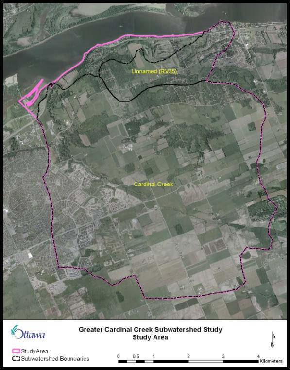
The study area (Figure 1, in attached Document 1) includes the Cardinal
Creek subwatershed and an adjacent unnamed subwatershed. The Cardinal Creek valley forms the basis of
the urban boundary in eastern Ottawa, with most of the study area being located
in the rural area of former Cumberland.
In
preparation for this subwatershed study, the Environmental Sustainability
Division initiated several field studies in 2006. These studies included an inventory of plants and wildlife, an
assessment of the physical state of the creek channels, and an assessment of
the creek flows and fish communities.
As part of the 2007 budget, Council approved the allocation of development charge funding to assess, monitor, design and construct erosion control measures within the Cardinal Creek valley (project account number 903223). The need for these measures was identified in conjunction with the stormwater management solution for the urban portion of the study area. The initial stages of this work will be carried out as part of the subwatershed study.
DISCUSSION
The
attached Terms of Reference outlines the major tasks and approach for the
subwatershed study, and will form the basis of the contractual agreement with
the selected consulting team. Minor
adjustments to these terms may be agreed to by the City and the consulting team
as required during the study.
The
first task of the study team will be to combine the 2006 field study findings
with additional analysis in the areas of hydrology, hydrogeology, geotechnical
engineering and land use, as the basis for the subwatershed plan. The team will then develop an integrated
management plan for the subwatersheds in consultation with the City, the study
Advisory Committee, the public and the various stakeholder groups. The successful implementation of the plan
will depend on the support of stakeholder agencies, the landowners, and the
general public.
The
Lower Rideau Watershed Strategy, endorsed by Council in November 2006, promotes
an integrated approach by agencies at the municipal, provincial and federal
levels for addressing the monitoring, assessment, and protection of the
environment on a watershed basis. It
will be used as a framework for the recommendations of the subwatershed plan.
The
key tasks of the study are:
a) Complete the characterisation of the existing conditions and the natural heritage system for the subwatersheds;
b) Define the environmental opportunities, issues and constraints created by the natural heritage system and existing land use;
c) Calibrate and verify an existing hydrologic model of Cardinal Creek based on flow monitoring data collected by the City of Ottawa in 2006 and 2007;
d) Develop a subwatershed plan, including goals and objectives consistent with the framework established by the Lower Rideau Watershed Strategy;
e) Identify any monitoring requirements specific to this subwatershed needed to augment the overall monitoring strategy being developed by the City as part of the Lower Rideau Watershed Strategy implementation;
f) Where not previously addressed through development approvals within the subwatersheds, establish setbacks from watercourses and provide additional direction regarding the scope of required Environmental Impact Statements;
g) Establish an implementation strategy including mechanisms/tools, roles and responsibilities of agencies and other stakeholders, costs, sources of funding and priorities for specific recommendations; and,
h) Fulfill Phases 1 and 2 of the Master Plan process of the Municipal Class Environmental Assessment and the Canadian Environmental Assessment Act, if applicable, to identify preferred conceptual solutions for needed slope stability/erosion control or stream rehabilitation works. These works will be prioritised based on a risk assessment framework to be developed in consultation with the City.
ENVIRONMENTAL IMPLICATIONS
The
purpose of the subwatershed study is to identify ways in which the City, its
residents and other stakeholders can preserve or enhance the environment by
reducing or avoiding impacts and by addressing existing issues.
The study will be conducted under the Municipal Class Environmental Assessment process. Other regulatory agencies with an interest in the project (Ministry of Environment, Ministry of Natural Resources, Rideau Valley Conservation Authority, Department of Fisheries and Oceans) will be invited to participate on an Advisory Committee for the study.
RURAL
IMPLICATIONS
Most of the proposed study area is rural. The subwatershed study may produce recommendations regarding best management practices or other environmental protection measures for the rural area. The Rural Affairs Office will be invited to participate on the Advisory Committee for the study. The public consultation events will be scheduled for periods which facilitate participation by members of the farming community.
CONSULTATION
The
subwatershed study will be carried out under the Municipal Class Environmental
Assessment process, and will include a public consultation plan which meets or
exceeds the requirements of that process.
Public
consultation to date has included direct contact with landowners during the
2006 field studies, contact with the local Councillors' offices, a City of
Ottawa web page, and notification of each of the Environmental, Rural Issues,
and Forests and Greenspace Advisory Committees (EAC, RIAC and OFGAC). Members of EAC and OFGAC expressed interest
in participating in the study as it progresses. Members of RIAC expressed concerns with regard to the purpose of
subwatershed studies in general and in the present case, and the potential for
restrictions to be placed on rural residents' use of their properties. Staff indicated that the purpose of the
study was to identify and address environmental issues, and that recommendations
would likely involve Best Management Practices for land stewardship in the
rural area. Staff will also attempt to
address these concerns through better communications with RIAC and the public
regarding subwatershed studies in general.
The City's project manager will work with EAC, OFGAC and RIAC to ensure
that they are kept informed about the study and are able to provide input as it
progresses.
Some
rural landowners contacted during the 2006 field surveys also expressed
concerns over potential restrictions on the use of private lands as a result of
this study. Rural residents also
expressed a preference for fall or winter consultation, which has been
accommodated within the proposed schedule for the project.
The Cardinal Creek Community Association has contacted the City project manager to express its interest in participating in this study. This group and other interested community groups will be notified of the public consultation events. The consultation program will be adjusted as needed to respond to community interest.
FINANCIAL IMPLICATIONS
The
cost of the 2006 field study contracts was $75,000. The cost to complete the subwatershed study based on the attached
Terms of Reference is estimated at $150,000 to $200,000. Additional costs related to the public
consultation process are estimated at $50,000.
The total cost of the Greater Cardinal Creek Subwatershed Study is
therefore $275,000 to $325,000. The
funding to carry out this study has already been approved by Council as part of
the 2006 and 2007 budget allocations in project number 902042
Watershed/subwatershed Planning and 903223 Storm Water Management - Cardinal
Creek Erosion, respectively.
Including
the initial stages of the Cardinal Creek erosion control work in this
subwatershed study will streamline the consultation process and allow issues
within the valley to be addressed more strategically. This approach maximises the effectiveness of the available
funding.
The study will be completed by a qualified consulting team managed by City of Ottawa staff. The consulting team will be selected through a Request for Proposals process in accordance with the City of Ottawa's standard practices for acquisition of services.
SUPPORTING DOCUMENTATION
Document 1 - Greater Cardinal Creek Subwatershed Study: Terms of Reference
DISPOSITION
Environmental Sustainability staff will initiate the subwatershed study upon approval of the Terms of Reference.
Terms
of Reference
Greater Cardinal Creek Subwatershed Study
1. INTRODUCTION
The City of Ottawa requires a subwatershed study and management plan for the Greater Cardinal Creek Subwatershed. An understanding of the relationships among the biotic and physical environmental systems is required to ensure the identification and protection of groundwater resources, woodlands, streams, and other valued ecosystem features and functions. Drawing on fieldwork and scientific analysis, the subwatershed plan will identify stressors affecting natural systems and propose measures to mitigate these stressors, correct any existing issues and where possible enhance the natural heritage system. A subwatershed plan attempts to balance environmental protection, conservation, and restoration efforts with land-use practices and development activities to ensure the long-term health of the subwatershed. Integration of the various scientific disciplines involved in the study is critical to the production of an effective subwatershed plan. The successful implementation of the plan will depend on the involvement and support of a wide range of stakeholder agencies, the landowners, and the general public.
Summaries of the results of each of the three field studies commissioned by the City in 2006 are included in this Terms of Reference as Appendix 1. These studies included an inventory of the terrestrial environment (Marshall Macklin Monaghan, May 2007), a geomorphic assessment (Geomorphic Solutions, April 2007), and an assessment of the creek flows, water quality, fish and benthic communities (City of Ottawa, 2006-2007). The complete studies and datasets will be provided to the successful bidder. City staff will also provide an analysis of the existing stormwater management facilities and catchment areas within the urban portion of the study area.
A map of the Cardinal Creek (RV34) and adjacent Ottawa River 1 (RV35) subwatersheds is provided in Figure 1. The subwatershed boundaries have been refined based on the geomorphological investigations, and extend south from the Ottawa River shoreline approximately to Regimbald Road between Tenth Line Road and Dunning Road.
1.1
Study Area
1.1.1 Cardinal Creek
The Cardinal Creek subwatershed, identified as RV34 on Figure 1, is part of the Ottawa River watershed, and includes several municipal drains as well as small, unnamed tributaries. The subwatershed includes over 3,100 hectares. Land use within the study area is predominantly agricultural with areas of existing and approved urban development in Orléans and rural estate lot development in the Cumberland area. The Cardinal Creek valley forms the basis of the urban boundary in eastern Ottawa. The urban lands within the subwatershed are now under development, with plans already implemented or approved for most areas within the urban boundary. Given the subwatershed’s location at the urban boundary, several large landowners in the rural area are interested in securing an urban designation. The City of Ottawa Council will make a decision on the need for additional urban land in this area or elsewhere in the City in 2008 as part of the Official Plan Review. For the purposes of this subwatershed study, it is assumed that the dominant land use in the rural area will remain agriculture, continuing the historic pattern of farming. This study needs to consider how to effectively protect and enhance the remaining natural features and functions of the subwatershed while also supporting the ongoing agricultural uses and integrating development where it is currently permitted.
The subwatershed contains part of the provincially significant Petrie Islands Wetland and associated candidate life science Area of Natural and Scientific Interest (ANSI). The subwatershed also contains forested areas identified in the former Regional Municipality of Ottawa-Carleton’s Natural Environment Systems Strategy (NESS) and the City’s Urban Natural Areas Environmental Evaluation Study (UNAEES). Some of the larger natural features have already been partially developed as rural estate lot subdivisions. Several other woodlands and natural features, including open meadows and shrublands, have also been identified and evaluated as part of the 2006 terrestrial inventory. A karst cave system which conveys the creek flow underground for a distance of approximately 250 metres is of interest geologically.
A Master Drainage Plan (MDP) for the urban area in the former municipality of Cumberland was prepared in 1992 by McNeely Engineering Consultants Limited, and subsequently updated and supplemented by Cumming Cockburn Limited in 2001. Various supporting reports to these master planning documents were also prepared by consultants. Following the completion of the MDP for the Cumberland expansion area, the preferred servicing solution was implemented through the construction of an on-line stormwater management pond in Cardinal Creek upstream of Watters Road. By-laws were enacted in 2004 to enable the City to collect financial contributions from the various urban developers benefited by this stormwater facility. The MDP and detailed design brief for the pond identified concerns regarding slope stability and erosion of the banks along the Cardinal Creek valley, which will need to be addressed as part of this subwatershed study.
1.1.2 Unnamed Creek
The Ottawa River 1 (RV35) subwatershed is drained by an unnamed creek which flows into the Ottawa River in the Village of Cumberland, and by several smaller channels draining directly to the Ottawa River. The subwatershed is approximately 550 hectares in size and is illustrated along with the Cardinal Creek subwatershed in Figure 1. Land use within the study area is rural and includes residential, agricultural and commercial recreational uses, with village development in Cumberland. The subwatershed includes several provincially significant escarpment-based vegetation communities, as well as a regionally significant earth science ANSI (Highway 17 Quarry) and a locally unique physiographic feature (mud flow scar).
The terrestrial and geomorphic field studies commissioned by the City in 2006 in preparation for the Greater Cardinal Creek Subwatershed Study included the RV 35 subwatershed area. City of Ottawa staff will undertake the aquatic resources assessment for this creek system in 2007.
1.2
Project
Tasks and Objectives
The
first task of the project team will be to successfully integrate the 2006 field
study findings with the necessary additional study disciplines in the areas of
hydrology, hydrogeology, geotechnical engineering and land use planning, as the
basis for the subwatershed plan. To
facilitate this process, the City will solicit the input of the previous field
study teams through workshops or other means, to support the work of the project
team. The team will then develop a management plan for the subwatersheds in
consultation with the City, the study Advisory Committee, the public and the
various stakeholder groups. The
subwatershed plan should reflect the differences in land uses and associated
stressors occurring in the urban and rural portions of the study area.
The
study will be required to fulfill Phases 1 and 2 of the Municipal Class
Environmental Assessment process, with regard to identifying conceptual
alternatives and preferred solutions to address slope stability and/or erosion
issues in the Cardinal Creek valley that threaten public health and safety,
infrastructure, public/private property, or subwatershed health. The
subwatershed plan will prioritise recommended slope stability/erosion control
or stream rehabilitation works on the basis of risks to public safety, property
or infrastructure, and subwatershed health. The consultant will develop a risk
assessment framework, to be approved by the City, that will facilitate the
prioritisation of recommended works.
Budget is available to address the most immediate needs within the
Cardinal Creek valley in 2007-2008, with future funding needs to be assessed in
2008. Thus, the subwatershed plan will
be expected to provide guidance in how, where and when the City’s limited
resources should be directed within the study area.
In
November 2006, City Council endorsed the Lower Rideau Watershed Strategy, which
promotes an integrated approach by the responsible agencies at the
municipal, provincial and federal levels for addressing the monitoring,
assessment, and protection of the environment on a watershed basis. While the Greater Cardinal Creek
Subwatershed Study area is not part of the Rideau River watershed, it is within
the Rideau Valley Conservation Authority’s jurisdiction. Furthermore, the basic principles of the
Lower Rideau Watershed Strategy can be applied equally well across the City of
Ottawa. Therefore, the recommendations
of the Greater Cardinal Creek Subwatershed Study should relate to those of the
Lower Rideau Watershed Strategy.
The key
tasks of the study are:
a) Complete the characterisation of the existing conditions
and the natural heritage system for the subwatersheds;
b)
Define the environmental
opportunities, issues and constraints created by the natural heritage system
and existing land use;
c)
Calibrate and verify an
existing hydrologic model of Cardinal Creek based on flow monitoring data
collected in two locations by the City of Ottawa from spring through fall in 2006
and 2007;
d)
Develop a subwatershed plan,
including goals and objectives consistent with the framework established by the
Lower Rideau Watershed Strategy;
e)
Identify any monitoring
requirements specific to this subwatershed needed to augment the overall monitoring
strategy being developed by the City as part of the Lower Rideau Watershed
Strategy implementation;
f)
Where not previously
addressed through development approvals within the subwatersheds, establish
setbacks from watercourses and provide additional direction regarding the scope
of required Environmental Impact Statements;
g)
Establish an implementation
strategy including mechanisms/tools, roles and responsibilities of agencies and
other stakeholders, costs, sources of funding and priorities for specific
recommendations; and,
h)
Fulfill Phases 1 and 2 of the
Master Plan process of the Municipal Class Environmental Assessment and the
Canadian Environmental Assessment Act, if applicable, to identify preferred
conceptual solutions for needed slope stability/erosion control or stream
rehabilitation works. These works will
be prioritised based on a risk assessment framework to be developed in
consultation with the City.
2. STUDY COMPONENTS
The
basic outline of the study process is as follows:
a) Finalize Terms of Reference;
b) Develop Existing Conditions Report addressing:
i. Earth sciences, including hydrogeology;
ii. Surface water (quality and quantity);
iii. Geomorphology;
iv. Terrestrial ecology;
v. Aquatic ecology; and,
vi. Existing land use.
c) Develop Subwatershed Plan, including:
i. Recommendations for future development review;
ii. Preferred solutions for creek restoration and slope stabilisation; and,
iii. Implementation plan.
Each of these study components is described in further detail below. It is expected that the City of Ottawa project manager and other staff will be actively involved throughout the study process (see also Section 2.4.2 below).
2.1 Finalize Terms of Reference
This Terms of Reference will be reviewed and approved by City Council. City staff and the selected consulting team may also agree to minor adjustments to the Terms of Reference as needed to respond to changes in the circumstances and context of the project as it progresses.
2.2 Existing Conditions Report
A succinct Existing Conditions Report will be produced which describes the existing conditions within the study area by summarising the 2006 field studies, other background information, and supplementary investigations. The analysis of existing conditions will identify key interrelationships between resources, issues, opportunities and constraints. Geographic Information Systems (GIS) will be the required tool used to graphically represent the subwatersheds’ natural systems. This information will form the basis of the first public consultation event to be held in the late fall of 2007 following the harvest season.
2.2.1 Background Review
The City of Ottawa will provide the consulting team with completed reports and datasets, along with an ArcView Geodatabase including such standard themes as soil types, land use, stream fabric, land cover, current air photos and topography. The field studies undertaken for the subwatersheds in 2006 and the previous MDP are expected to comprise a significant part of the background information for this study. The consultants will rely on the analyses provided from the terrestrial inventory and the geomorphic assessment, rather than re-analysing existing data.
2.2.2 Supplementary Investigations
It is expected that there will be minimal additional fieldwork required to complete this study. Limited field investigations may be undertaken to improve the consultants’ familiarity with the study area and to supplement the existing information base, particularly with regard to identifying and prioritising creek rehabilitation and slope stabilisation works. Any fieldwork by the consulting team will be scheduled for the 2007 field season. The City of Ottawa will be responsible for obtaining permission to access private property.
The scope and methodologies for all fieldwork will be developed in consultation with the study’s Advisory Committee and the City of Ottawa and will follow approved City methodologies. The consulting team will work with the City of Ottawa and other study partners to collect necessary data, i.e., water quality data will be collected by the City’s Water Environment Protection Program. Where possible, field work will be coordinated by the study team members to minimise the number of site visits and inconvenience to landowners. All data collected by the consultants will become the property of the City of Ottawa, and will be provided in an electronic format that is compatible with City software.
Earth
sciences, including hydrogeology
A reconnaissance survey to update the existing slope stability assessment of the Cardinal Creek valley (downstream of Innes Road) will be required. The goal of this survey will be to identify sites with erosion/slope stability concerns and rank these sites as requiring emergency (2007), immediate (2008), short-term (2009-2010) or long-term (beyond 2010) action, based on the combined geotechnical, geomorphological and hydrological information available. No intrusive sampling is anticipated to be required during this reconnaissance survey.
The subwatershed study should provide a general characterisation of the groundwater system within the study area, including areas of recharge and discharge, flow directions and water quality, based on a review of the Ontario Ministry of Environment’s well records and other available information. Field investigations are not anticipated as part of this study.
Surface water (quantity and quality)
The stormwater management solutions for the urban area have already been developed in the MDP and other development application-related studies. The subwatershed study will not be required to revisit the approved stormwater management for the existing urban area; however, it will recommend conceptual stormwater management requirements for any undeveloped lands within the Village of Cumberland (i.e., outline steps or studies required to confirm stormwater management criteria for future development of these lands).
An understanding of the projected
post-development hydraulics and hydrology of Cardinal Creek will be required to
inform and support the design of any required erosion control and slope
stability projects. A hydrologic model
has been developed for Cardinal Creek as part of the updated MDP. The consultant will use recently collected
flow data (see below) to update, calibrate and verify the model to reflect
existing conditions. All changes to the
model provided by the City will be documented.
Prior to undertaking this exercise, the consultant will review the model and confirm
the calibration and verification
processes via a written description for City staff and RVCA to review and
approve. The calibrated/verified
existing conditions model will also be reviewed and approved by the City and
RVCA prior to proceeding with the analysis.
Surface water quality and flow monitoring has been conducted by the City in two locations along the main channel of Cardinal Creek downstream of Innes Road in 2006. The City will also conduct surface water monitoring programs on Cardinal Creek and the unnamed RV35 creek during the 2007 field season. These data will be provided to the consultants.
Geomorphology
Geomorphic Solutions has completed a detailed geomorphological assessment at sites in both subwatersheds, as well as a more general overview of conditions throughout the study area. The report establishes meander belt widths and erosion thresholds for Cardinal Creek and the unnamed creek. The final report and data will be provided to the consultants.
Terrestrial
ecology
The terrestrial inventory undertaken by Marshall Macklin Monaghan produced the following deliverables:
· Maps identifying all terrestrial natural features (e.g., woodlands, wetlands, grasslands/meadows) in the study area which are 0.8 ha or greater in size;
· Classification of terrestrial natural features in terms of the local natural heritage system (e.g., significant species, key wildlife habitat and vegetation communities, functional linkages); and,
· Detailed inventories of selected natural features using the Ecological Land Classification system.
The final report and data will be provided to the consultants. Some updates and refinements to the mapped natural area boundaries will be required.
Aquatic
ecology
The City has completed a stream habitat assessment for the main channel of Cardinal Creek downstream of Innes Road, and will complete this work on the unnamed creek in 2007. This work collected information on fish communities and habitat assessment, delineation and classification of reaches, and benthic invertebrate communities. The data will be provided to the consultants.
The RVCA and the City jointly support a volunteer-based Macro Stream Assessment (City Stream Watch) Program, which completed macro stream assessments on the main stem of Cardinal Creek in 2003-2004. Macro stream assessments collect background information on the general in-stream and riparian characteristics at 100 m sections. This information will be provided to the consultants.
Land Use
Planning Context
The study area straddles the urban-rural boundary, and as such, is divided between Schedules A and B in the Official Plan. A full understanding of the land use context of the area is required to frame the subwatershed plan. The City will provide an overview of the current land use planning context and the existing land uses (e.g., urban residential, rural residential, agricultural, industrial, recreational) within the study area. A characterisation of the types of agriculture occurring within the study area will be needed when considering stewardship and best management practices options.
2.2.3 Reporting
The Existing Conditions Report must be concise and readable, providing a clear overview of the natural heritage system within the study area based on the integrated findings of the team. It will identify environmental issues, opportunities for environmental restoration or enhancement and potential constraints to future development. Descriptions of the various environmental components studied should provide information on both the typical and notable features observed. The report text should be complemented with effective summary tables and graphic illustrations. Detailed technical information, analyses, data tables and field notes should be provided in appendices or under separate cover, as determined by the City of Ottawa project manager. Electronic files (models, databases, maps, etc.) will also be provided to the City of Ottawa.
The report should as a minimum include the following maps:
· Basic study area map as provided by the City of Ottawa;
· Land use context map incorporating designations from the Official Plan, with additional information on existing land uses;
· Map of surface water features (including municipal drains) with names, where appropriate;
· Key map of existing natural heritage system and significant or sensitive features within the study area, based on the 2006 terrestrial inventory and additional analysis of surface and ground water features;
· Detailed maps showing portions of the natural heritage system with features of particular interest at finer scale, if necessary;
· Existing aquatic habitat conditions in the subwatershed area (e.g. natural versus altered reaches, barriers, in-stream habitat deficiencies, lack of riparian vegetation, stream health based on fish and benthic communities); and,
· Inventory of slope stabilisation/erosion control issues and/or potential channel restoration/enhancement areas, showing priorities for action.
These maps, or others that may be developed as the study progresses, will be expected to be included in the presentation materials at the first public consultation event in the late fall of 2007.
2.3 Subwatershed Plan
The
formulation of the subwatershed plan should be a collaborative and iterative
process between the study’s Advisory Committee members, the public and other
stakeholders, and the multi-disciplinary consulting team. This approach will help create a
comprehensive plan and increase local awareness and involvement.
The
subwatershed plan should:
a) Develop goals and objectives to address the issues, opportunities and constraints identified in the Existing Conditions Report, which are specific to the subwatershed and consistent with the framework established by the Lower Rideau Watershed Strategy;
b) Identify
the core elements of the natural heritage system within the subwatersheds that
need to be conserved, or which need additional study prior to development;
c) Provide a prioritised list of slope stabilisation/erosion control and/or potential channel restoration/enhancement projects, with preferred conceptual alternatives identified for each project along with an outline of any additional investigations and analyses required at the detailed design stage;
d) Recommend appropriate best management practices or other stewardship initiatives for rural landowners and also for urban residents living near natural features;
e) Where not previously addressed through development
approvals within the subwatersheds, establish setbacks from watercourses and
provide additional direction regarding the scope of required Environmental
Impact Statements;
f) Identify how the plan can be implemented through the tools available to the City and its partners (i.e., through stewardship programs, outreach and education, development review, capital projects to restore watercourses); and,
g) Identify any monitoring requirements specific to this subwatershed needed to augment the overall integrated monitoring strategy being developed by the City as part of the Lower Rideau Watershed Strategy implementation, including any recommendations for follow-up or interim monitoring that may be required on projects identified in item (c) above.
It is
expected that the recommendations for the rural portion of the subwatershed
study will primarily be directed towards private landowner stewardship
measures. The subwatershed plan should
identify which measures are likely to be effective in this study area, based on
the existing land uses, and how the City and other agency partners can support
them.
Many of the watercourses within the study area are municipal drains. The RVCA has classified these drains using the protocol developed jointly by the Department of Fisheries and Oceans and the conservation authorities. The City of Ottawa Drainage Superintendent and the RVCA will provide advice on any recommendations involving municipal drains in the study area.
2.4 Communication and Public Consultation
Communication
is a key component of this exercise.
The plan will guide the City of Ottawa and the Rideau Valley
Conservation Authority as they carry out their responsibilities for land use
and resource management in the study area, and will serve as a resource to the
federal Department of Fisheries and Oceans, provincial ministries, landowners,
developers, stewardship organizations, and the general public. An Advisory
Committee for the study will be established representing the key public sector
partners including the City of Ottawa, Rideau Valley Conservation Authority,
Department of Fisheries and Oceans, Ministry of Natural Resources and Ministry
of the Environment.
Consultation
with the landowners and general public will be administered by the City. The consulting team will support the City of
Ottawa project manager in the development and implementation of a consultation
plan consisting of public open houses, community newspaper articles and other
communications that satisfies or exceeds the requirements for Phases 1 and 2 of
the Municipal Class Environmental Assessment process.
2.4.1 Advisory Committee
An Advisory Committee will be established at the commencement of the study with representation from the following groups and organizations:
a) City of Ottawa
b) Rideau Valley Conservation Authority;
c) Ontario Ministry of Environment;
d) Ontario Ministry of Natural Resources;
e) Ontario Ministry of Agriculture and Food; and,
f) Federal Department of Fisheries and Oceans.
The consultant team will regularly consult with the study’s Advisory Committee to obtain input and guidance on the concepts and direction of work. It is anticipated that approximately three Advisory Committee meetings will be required. The first meeting, shortly following the initiation of the project, will include a tour of the subwatershed study area. The second and third meetings will precede the public consultation events in the fall of 2007 and the early spring of 2008.
2.4.2 Subwatershed Study Working Group
A working group of key members of the study’s Advisory Committee will be established to meet more frequently and provide regular input to the consultant team. Workshops will be held in Ottawa during the development of the Existing Conditions Report and the subwatershed plan, which will include members of the various 2006 field study teams.
2.4.3 Community Advisors
The City of Ottawa project manager will be responsible for providing regular updates on the study to Council’s advisory committees (i.e., Rural Issues, Environmental and Forests and Greenspace) and the local community associations. These updates will be provided either through the regularly scheduled meetings of the target group, or via other means as agreed upon with the group.
2.4.4 Landowner Contact
The City of Ottawa project manager will coordinate the necessary landowner contact for any required access to private lands. Over 70% of landowners contacted for access during the 2006 field studies responded to the letter campaign, with almost 40% providing access.
The study may benefit from additional direct consultation with individual landowners. The City of Ottawa project manager will be responsible for arranging all such consultation. Various members of the consultant team may be required to contribute information or attend meetings with landowners, depending upon the topics to be discussed.
2.4.5 Public Consultation
Public consultation for the study will include newspaper advertisements, open houses, articles in community newspapers and the City of Ottawa web site. There is an extensive francophone community in the study area. The City of Ottawa will be responsible for translating all consultation materials as needed. The City of Ottawa project manager will be responsible for coordinating and issuing all advertisements, articles and web page updates with the assistance of the consultant team in preparing the content. The consultant will be responsible for preparing all presentation materials including posters, Powerpoint presentations and handouts and will ensure that the appropriate team members, including bilingual staff, are present at the two open houses to be held. These open houses will occur at the following milestones:
a) Presentation of existing conditions findings (late fall 2007); and,
b) Presentation of subwatershed plan (early spring 2008).
2.4.6 Project
Coordination
All communications with landowners and the public, stakeholders, partners, study Advisory Committee and community groups will be coordinated through the City of Ottawa project manager:
Ms. Amy MacPherson, Planner II, Environmental Sustainability
Planning, Environment and Infrastructure Policy
Planning, Transit and the Environment
City of Ottawa
Phone: (613) 580-2424, ext. 14873
Fax: (613)
580-2459
Amy.MacPherson@ottawa.ca
3. STUDY DELIVERABLES AND MILESTONES
The City of Ottawa will be responsible for the following:
· Finalized Terms of Reference;
· Liaison with landowners and the public, stakeholders, partners, study Advisory Committee and community groups;
· Preparation of master contact lists;
· Development and delivery of the landowner contact program;
· Preparation and distribution of notifications, news articles, etc.;
· Events planning and advertising;
· Updates to City of Ottawa web site;
· Provision of data (e.g., previous reports, Geodatabase, and other data as required); and,
·
Document
translation services.
The Consultant will be responsible for all other study deliverables and milestones including the following:
a) Regular (at least weekly) contact with the project manager to ensure that the concepts and direction of work reflect the Terms of Reference for this study;
b) Work plan for the study based on the final Terms of Reference, including due dates for all deliverables, meetings and milestones;
c) A written description of the calibration and verification process to be used with the hydrologic model;
d) Background materials, presentations and minutes for all Working Group and study Advisory Committee meetings;
e) Draft Existing Conditions Report (electronic versions in Word and PDF plus 30 hard copies);
f) Final Existing Conditions Report (30 hard copies, 1 print ready copy, PDF copy on CD) with supporting field notes and data files (digital files preferred);
g) Preparation of presentation materials for all public consultation events;
h) Draft Subwatershed Plan (electronic versions in Word and PDF plus 30 copies);
i) Final Subwatershed Plan (30 copies, 1 print ready copy, PDF copy on CD) and supporting data files (digital files preferred); and,
j) Final report presentation materials for appropriate City Standing Committees (Planning and Environment Committee and Agriculture and Rural Affairs Committee) and Council.
k) All data and models including calibrated hydrologic model.
The City of Ottawa project manager will be kept informed regarding the progress of all field investigations, with specific priority given to the identification of any slope stability/erosion control issues in the Cardinal Creek valley that may require immediate action.
The consultant is responsible for the preparation of all presentation materials, printing and photocopying, unless other arrangements are agreed upon during the course of the study.
All data prepared as part of this work is the property of the City of Ottawa and copies will be provided as a deliverable of this work. The methodologies developed by the consultant for this study may be used by the consultant for other work. However, the data may not be used for any other purpose without the express permission by the City of Ottawa.
The final Existing Conditions Report and Subwatershed Plan documents should be accompanied by all information relative to the study process, recommendations, and findings. The entire study, including raw data, must be provided to the City of Ottawa in an electronic format agreed upon in consultation with City staff on CD as well as reproducible hard copy format. The electronic versions of the reports should be provided in both Microsoft Word and Adobe Acrobat (PDF). Mapping used during the study must be compatible with the City of Ottawa GIS platform (ArcView 9.0) and available for transfer as digital files. Any figures produced for the study must be compatible with City software.
The end product should be
interesting and easily understood by a wide readership and demonstrate a direct
linkage between issues and the recommended actions. All copies of the main reports and appendices will be double
sided, and will be reproducible in black and white. The final Existing Conditions Report will be concise and
well-integrated, not a compilation of sub-reports prepared for this study. The final Subwatershed Plan will not exceed
100 pages, unless otherwise agreed upon with the City of Ottawa and the study’s
Advisory Committee.
4. STUDY SCHEDULE AND RESOURCE ALLOCATION CHART
The proposal shall clearly identify the project manager and document his or her role and contribution to this study. A resource allocation chart shall be provided with a breakdown of the major tasks and the level of effort of the identified team members. This chart should indicate what task is to be fulfilled by whom and at what stage in the study process. Once the Terms of Reference have been finalised, any changes in personnel will need to be approved by the City.
The proposal shall include a clear project schedule with defined deliverable dates, consistent with the general timeline provided below.
|
Table: Greater Cardinal Creek Subwatershed Study
Timeline |
|
|
Milestone |
Approximate Date |
|
Finalise Terms of Reference |
Early July 2007 |
|
Study notification – newspaper ad, etc. (reference to open house in late fall 2007) |
Early July 2007 |
|
Project initiation meeting – information transfer and field work planning |
Mid July 2007 |
|
First Advisory Committee meeting – study kickoff and study area tour |
Mid July 2007 |
|
First Working Group meeting – field work reporting |
Late August 2007 |
|
Second Working Group meeting – input to draft existing conditions report, issues/opportunities/constraints |
Early October 2007 |
|
Draft Existing Conditions Report submission |
Late October 2007 |
|
Second Advisory Committee meeting – draft existing conditions report and open house preparation |
November 2007 |
|
First Open House – existing conditions |
November 2007 |
|
Final Existing Conditions Report submission |
December 2007 |
|
Third Working Group meeting – input to draft plan; goals and objectives, priorities, alternatives |
December 2007 |
|
Draft Subwatershed Plan submission |
Early February 2008 |
|
Third Advisory Committee meeting – draft subwatershed plan and preferred alternatives |
March 2008 |
|
Second Open House – subwatershed plan and preferred alternatives |
March 2008 |
|
Final Subwatershed Plan submission |
April 2008 |
|
Study to PEC/ARAC |
May/June 2008 |
|
Council Approval |
Summer 2008 |
|
Notification of Study Completion (following 30 day review period mandated by EA process) |
Late summer 2008 |
5. FINANCIAL PROPOSAL
The consultant’s submission will include a Financial Proposal with a total upset limit price between $150,000 and $200,000. The Financial Proposal will indicate the estimated budget allocation for each of the major study tasks and will clearly identify the specific costs of the geotechnical investigations and the public consultation activities required by the Municipal Class Environmental Assessment process as separate items within the overall budget. The upset limit price should include all fees, disbursements and taxes to complete the entire assignment in accordance with the services detailed in the Terms of Reference and in the consultant’s proposal.
The study budget is an upset limit and will not be exceeded without approval by the City of Ottawa.
The consultant will be required to sign an agreement of which the finalised Terms of Reference forms a part.
Figure 1: Study Area Boundary
Appendix 1: Summary Outlines of 2006 Field Study Results
Terrestrial Inventory
In May 2006, Marshall Macklin Monaghan Limited was retained to conduct a background review, life science inventory, and natural areas classification of the terrestrial environment within the Greater Cardinal Creek Subwatershed Study area identified by the City of Ottawa. Ecologically, the study area is situated within the St. Lawrence Lowlands Ecoregion of the Mixedwood Plains Ecozone and within Site District 6-12 of the Lake Simcoe – Rideau Site Region 6E.
Thirty-seven Natural Features were identified by the City of Ottawa for inclusion in the Greater Cardinal Creek Terrestrial Inventory. The features to be inventoried and assessed were the following: six Natural Environment System Strategy (NESS) areas that were identified by the Regional Municipality of Ottawa-Carleton in 1995 (NESS 44, NESS 45, NESS 46, NESS 47, NESS 48, NESS 63); three Urban Natural Areas that were identified by the City of Ottawa in 2005 (UNA 92, UNA 94, UNA 95); one candidate Life Science Area of Natural and Scientific Interest that was identified by the Ontario Ministry of Natural Resources in 1992 (French Hill Maple Woods) (Natural Feature NF27); and, all unexamined woodlands and wetlands greater than 0.8 ha in size (Natural Features NF1 through NF26 and NF28). NESS 63 has been displaced by development and was not available for examination during the 2006 field survey.
Seven dimensions of ecological functions were assessed for each feature: landform representation, rare vegetation community/landform representation, significant wildlife habitat, terrestrial contribution to aquatic ecosystems, valleylands and contiguous tableland forest, and connectivity to other natural features. Natural features with high ecological scores were typically large features that were situated in a landscape with high forest cover, on more than one physical landform type, with potential to serve as wildlife habitat, and that contained a headwater stream or watercourse. At least some portion of most of these features were surveyed for breeding birds, rare plants, rare vegetation types, and, typically, for areas of groundwater discharge or upwelling. Natural features with lower scores were typically small, isolated features on uniform landform types in landscapes of low forest cover. These features had typically not been included in field surveys for breeding birds, rare plants, rare vegetation types or areas of groundwater discharge. Further study may be warranted if development is proposed within or adjacent to these features.
The inventory report concludes by classifying each identified natural feature as either a core or supporting element of the local terrestrial natural heritage system, based on a set of nine basic principles. Recommendations are made as to which natural features require additional study (i.e., at the development application stage) to confirm their status as core or supporting elements.
Overall findings for the study include:
· Bedrock in the study area consists primarily of Ordovician limestone of the Ottawa Formation with a narrow band of black shale of the St. Martin Formation that parallels Old Montréal Road, and a narrow to broad band of grey-green shale with sandstone lenses of the Rockcliffe Formation which lies between the St. Martin Formation and the Ottawa River.
· A small karst formation is present on the valley floor of Cardinal Creek and adjacent tableland in the vicinity of Watters Road. This formation is composed of an upstream sink area, where the water of Cardinal Creek enters the underground cave system; underground bedrock channels; springs at the downstream end of the karst formation from which the flow in Cardinal Creek exits the underground channels; and, two large surficial sinkholes.
· Surface deposits in the study area are dominated by clay plains with small outcrops of limestone plain present along French Hill Road in the vicinity of Natural Features NF27 and NF28 and along O’Toole Road in the vicinity of Natural Feature NF20 and NESS 48. A band of till plain (undrumlinized), a rare surface deposit in the City of Ottawa, occurs along Wilhaven Road and Old Montréal Road, between Frank Kenny Road and Quigley Hill Road, in the vicinity of NESS 44, NF9, NF11, and NESS 48. The remnants of a mud flow scar are present in the vicinity of the Camelot Golf and Country Club at Regional Road 174 and Quigley Hill Road.
· Soils in the study area are dominated by poorly-drained Rideau and Bearbrook clay soils on the clay plains and by well-drained Farmington and Grenville sandy loam soils on the limestone plains and till plains, with poorly drained Goulbourn organic soils present at the headwaters of the unnamed creek in the Ottawa River 1 subwatershed. Escarpments with talus slopes are present in the vicinity of French Hill, along Wilhaven Drive, and south and parallel to Regional Road 174.
· Forests cover approximately 18.5% of the study area. The median patch size is 1.6 ha (range 0.01 ha to 88.6 ha). The dominant forest vegetation types are Fresh-Moist Lowland Ash Deciduous Forest (FOD7-2), Fresh-Moist Sugar Maple – Lowland Ash Deciduous Forest (FOD6-1), Dry-Fresh Sugar Maple – Basswood Deciduous Forest (FOD5-6), and Fresh-Moist White Cedar – Sugar Maple Mixed Forest (FOM7-1).
· Wetlands identified during the 2006 field survey cover approximately 1.1% of the study area. The median patch size is 0.2 ha (range 0.1 ha to 7.6 ha). The dominant wetland vegetation types are Green Ash Mineral Deciduous Swamp (SWD2-2), Reed-canary Grass Mineral Meadow Marsh (MAM2-2) and Willow Mineral Thicket Swamp (SWT2-2).
· Forty-four vegetation types were recorded during the Ecological Land Classification of the study area, including six provincially rare vegetation types: Bulblet Fern – Herb Robert Carbonate Open Cliff (CLO1-2) (S3), Canada Bluegrass Carbonate Open Cliff (CLO1-3) (S3), Moist Open Carbonate Cliff Seepage (CLO1-4) (S3), Dry-Fresh White Cedar Carbonate Treed Talus (TAT1-2) (S3), Fresh-Moist Sugar Maple Carbonate Treed Talus (TAT1-4) (S3), and Fresh-Moist Hemlock – Sugar Maple Carbonate Treed Talus (TAT1-6) (S2).
· Three-hundred and sixty-two species of vascular plants were recorded during the plant inventory for this study, including the provincially rare Hayden’s Sedge (Carex haydenii) (S3) and five species which are rare in the City of Ottawa: Ontario Aster (Symphyotrichum ontarione var. glabratum) (R0), Canada Manna Grass (Glyceria canadensis) (R3), Anise-root (Osmorhiza longistylus) (R5), Ontario Aster (Symphyotrichum ontarione var. ontarione) (R9), and, Wheat Grass (Elymus trachycaulus) (R10).
· Ninety-three species of birds were recorded during the breeding bird survey for this study. All but three of the recorded species are considered to breed in the Cardinal Creek and Ottawa River 1 subwatersheds.
· Fourteen species of amphibians and reptiles were either observed or reported from the study area: American Toad (Bufo americanus), Gray Treefrog (Hyla versicolor), Western Chorus Frog (Pseudacris triseriata) Wood Frog (Rana sylvatica), Northern Leopard Frog (Rana pipiens), Green Frog (Rana clamitans), American Bullfrog (Rana catesbeiana), Northern Two-lined Salamander (Eurycea bislineata), Snapping Turtle (Chelydra serpentine), Midland Painted Turtle (Chrysemys picta), Northern Map Turtle, Blanding’s Turtle, Common Gartersnake (Thamnophis sirtalis) and Northern Watersnake (Nerodia sipedon).
· Several species of mammals have been observed in the study area or are expected to occur in the study area. Observed species include White-tailed Deer (Odocoileus virginianus), Red Fox (Vulpes vulpes), Beaver (Castor canadensis), Muskrat (Ondatra zibethicus), Raccoon (Procyon lotor), Woodchuck (Marmota monax), Grey Squirrel (Sciurus carolinensis), Red Squirrel (Tamiasciurus hudsonicus), Eastern Chipmunk (Tamias striatus). Expected species include Coyote (Canis latrans), Eastern Cottontail (Sylvilagus floridanus), Snowshoe Hare (Lepus americanus), Mink (Mustela vison), Ermine (Mustela erminea), Long-tailed Weasel (Mustela frenata), Star-nosed Mole (Condylura cristata), Striped Skunk (Mephitis mephitis), various shrews, mice, voles and bats. Porcupine (Erethizon dorsatum) and Northern Flying Squirrel (Glaucomys sabrinus) are also possible; Black Bear (Ursus americanus) and Moose (Alces alces) are unlikely transients.
· Invertebrates were not included in the terms of reference for this study. Several species of spiders, butterflies, dragonflies, damselflies and various other arthropods and gastropods were noted incidentally during the field investigations. Adult Monarchs were observed to be abundant in the study area during August 2006.
· Four Species at Risk in Ontario are present in the study area: Butternut (Juglans cinerea) (OMNR Endangered – Not Regulated), Blanding’s Turtle (Emydoidea blandingii) (OMNR Threatened), Northern Map Turtle (Graptemys geographica) (OMNR Special Concern) and Monarch (Danaus plexippus) (OMNR Special Concern). Two additional Species at Risk, Stinkpot (Sternotherus odoratus) (OMNR Threatened) and Milksnake (Lampropeltis triangulum) (OMNR Special Concern), have been reported from the vicinity of the study area. These species are likely to occur in the study area owing to the presence of apparently suitable habitat. All of these provincially significant species are also regulated by the federal Species at Risk Act (SARA).
Geomorphology
The overall aim of the study was to develop an understanding of the
geomorphology of the watercourses within the Cardinal Creek watershed (RV34)
and the adjacent Ottawa 1 subwatershed (RV35). This study provides support to
future subwatershed studies by assessing stream health and sensitivity, and identifying
systematic adjustments and areas of potential concern with regard to
degradation and hazard.
The study was approached in two phases – preliminary assessment and detailed assessment. The preliminary assessment included a review of previous reports to provide background on the local geomorphology and controlling factors (i.e., hydrology and geology). Watercourses were then identified, and reaches were delineated including an historical evaluation of reach change over time. The field component of the preliminary assessment included rapid field evaluations (i.e., Rapid Geomorphic Assessment, Rapid Stream Assessment Technique) of each reach and identification of those with the greatest sensitivity.
The results of the RGA and RSAT assessments indicated that most of the reaches within the lower sections of the Cardinal Creek subwatershed are in transition. The headwaters of RV35 are in regime while the downstream reaches are in transition. The limited land use changes over the past one hundred years and local geology (i.e., silt and clay deposits) likely makes many of the reaches reasonably resilient to erosion. Those reaches showing the greatest adjustment are generally flowing through areas with increased gradients.
Overall the channels were relatively ‘healthy’ and reasonable stable, this condition is a product of the limited loss of headwater channels. The main issues with regards to stability and ‘health’ are associated with the loss of riparian vegetation, and straightening and ditching of headwater channels to facilitate drainage. The prominence of drains, along with urbanization downstream are likely the cause of the observed adjustment of the reaches along the main branch of Cardinal Creek. Steep gradients and valley wall contact are the likely cause of the observed adjustment along RV35.
The detailed assessment phase involved the application of detailed geomorphic measurements to the sensitive indicator reaches identified during the preliminary assessment. These reaches were used to quantify erosion thresholds to provide acceptable limits that should prevent an increase in channel erosion and deposition beyond natural rates. The exercise suggested that the watershed would be sensitive to changes in flow regime even for low magnitude flow events, such as those below the two-year return. These results can then be applied to assist with development of suitable stormwater management.
Aquatic
City of Ottawa Water Environment Protection Program staff established two hydrometric monitoring stations along the main stem of Cardinal Creek at the Innes Road and Old Montréal Road crossings in 2006. These permanent stations provide flow monitoring and water quality data from spring through fall. Fish and benthic communities were sampled at several locations along the main stem of Cardinal Creek between Innes Road and the Ottawa River during the summer of 2006. A hydrometric monitoring station will be established along the unnamed creek in 2007. Fish and benthic community sampling will also be undertaken on this creek in 2007.
The fish community upstream of the Watters Road crossing (in the on-line stormwater management pond) includes several common species of fish such as central mudminnow (Umbra limi), white sucker (Catostomus commersonii), fathead minnow (Pimephales promelas), creek chub (Semotilus atromaculatus), brown bullhead (Ameiurus nebulosus), brook stickleback (Culaea inconstans), pumpkinseed (Lepomis gibbosus) and Johnny or tessellated darter (Etheostoma sp.). Some additional species such as bluntnose minnow (Pimephales notatus) and longnose dace (Rhinichthys cataractae) were found farther downstream, below Old Montréal Road. The lower reaches of Cardinal Creek, below the former rail line crossing, support additional game species including rock bass (Ambloplites rupestris), black crappie (Pomoxis nigromaculatus), bluegill (Lepomis macrochirus), yellow perch (Perca flavescens), largemouth bass (Micropterus salmoides), walleye (Sander vitreus) and northern pike (Esox lucius), as well as smaller fish such as emerald shiner (Notropis atherinoides), trout-perch (Percopsis omiscomaycus) and tadpole madtom (Noturus gyrinus).