Report to/Rapport au :
Planning
and Environment Committee
Comité de l'urbanisme et de l'environnement
Submitted by/Soumis par : Nancy Schepers, Deputy City Manager
Directrice municipale adjointe,
Infrastructure
Services and Community Sustainability
Services d’infrastructure et Viabilité des collectivités
Contact
Person/Personne-ressource : John Smit, Manager/Gestionnaire, Development
Review-Urban Services/Examen des projets d'aménagement-Services urbains,
Planning and Growth Management/Urbanisme et Gestion de la croissance
(613)
580-2424, 13866 John.Smit@ottawa.ca
|
SUBJECT: |
ZONING - 2781, 2791, 2797 Baseline
Road and 2704, 2706, 2724, 2734 Draper Avenue |
|
|
|
|
OBJET : |
ZONAGE - 2781,
2791, 2797, chemin baseline et 2704, 2706, 2724, 2735, avenue draper |
REPORT RECOMMENDATION
That the Planning and Environment Committee recommend
Council approve an amendment to the Zoning By-law 2008-250 to change the zoning
of 2781, 2791, 2797 Baseline Road and 2704, 2706, 2724, 2734 Draper Avenue
from Residential Fourth Density Zone (R4N) to Residential Fifth Density
Exception Holding Zone (R5A[1700]S247-h) as shown in Document 1 and as detailed
in Document 3.
RECOMMANDATION DU
RAPPORT
Que le Comité de l'urbanisme et de
l'environnement recommande au Conseil d’approuver une
modification au Règlement de zonage 2008-250 visant à changer le zonage des
propriétés situées au 2781, 2791 et 2797, chemin Baseline ainsi qu’au
2704, 2706, 2724 et 2734, avenue Draper de Zone résidentielle de densité 4
(R4N) à Zone résidentielle de densité 5 d’exception à aménagement différé
(R5A[1700]S247-h) tel qu’il est indiqué au Document 1 et détaillé au Document
3.
BACKGROUND
The subject property is located in the Redwood Community and is bounded by Baseline Road to the south, Morrison Drive to the west and Draper Avenue to the north. At present, the property contains seven townhouse buildings with 12 units each for a total of 84 units. The property is 2.2 hectares in area and is surrounded by existing residential uses. The Redwood Community is a mixed-use area containing residential, light industrial and commercial uses. The community is also well served with two schools located east of the site on Draper Avenue. Abutting the property to the east is a townhouse development with 87 units. Across Morrison Drive to the west is a residential neighbourhood of mostly detached dwellings with a row of townhouses that face Morrison Drive. North of the site, across Draper Avenue, is an area of detached dwellings facing Draper Avenue. As Draper Avenue proceeds east, past the schools towards Greenbank Road, there are high rise apartments on the east side of Draper Avenue.
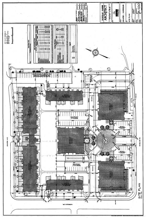
The applicant is proposing to redevelop the property into a multi-storey housing complex containing a mix of residential building forms ranging from stacked to mid-high rise apartment dwellings. The proposed development, as shown in Document 2, will consist of a total of seven buildings including two, three-storey stacked units (Buildings C and D), two, four-storey apartments (Building A and B), one, six-storey apartment (Building G), one, eight-storey apartment (Building F) and one, 12-storey apartment (Building E). A total of 334 dwelling units are proposed with parking to be provided predominantly in an underground parking garage located under Buildings E, F and G. The number of units and building heights are summarized in the chart below:
Building
|
Number of Units
|
Storeys/Height Above Grade
|
|
A |
34 |
4 storeys/ 16 metres |
|
B |
34 |
4 storeys/16 metres |
|
C (stacked) |
13 |
3 storeys/13 metres |
|
D (stacked) |
13 |
3 storeys/13 metres |
|
E |
108 |
12 storeys/39 metres |
|
F |
71 |
8 storeys/27 metres |
|
G |
61 |
6 storeys/21 metres |
TOTAL
|
334 |
|
The applicant is requesting to rezone the property to an R5A [XXXX] with exceptions to deal with some specific zoning provisions. The applicant had originally proposed the two apartment buildings fronting on Baseline Road, identified as Buildings F and G, to have a height limit of 12 storeys, and the centrally located building, Building E, to have a height of 20 storeys for a total of 537 units. However, as a result of the public consultation process and staff negotiations with the applicant, building heights and number of units were reduced.
In order to redevelop the site as proposed, exceptions to the standard provisions dealing with maximum building height and minimum landscape buffers are required. The proposed development will be required to go through Site Plan Control, which will be used to control and regulate the various features on the site such as building location, landscaping, building elevations and on-site vehicular and pedestrian movement.
DISCUSSION
The site is designated General Urban Area in the Official Plan. This designation permits the development of a full range of housing types, in combination with conveniently located employment, retail, service, cultural, leisure and institutional uses. The Strategic Directions Section of the Official Plan advocates creating liveable communities by providing a full range and choice of housing types. The Strategic Directions also call for intensifying within existing development areas to accommodate the city’s projected population growth. Within the Greenbelt, it is expected that at least 40 per cent of new housing development will be in the form of townhouses and apartments. The City supports intensification within the General Urban Area if the proposed development complements the desirable characteristics and ensures the long-term vitality of the existing community.
Section 2.5.1 (Compatibility and Community Design) indicates that when reviewing a proposal for residential intensification, it is important to consider the new development in relation to the existing built form. Introducing new development into existing areas requires a sensitive approach to differences between the new development and the established area. However, allowing for flexibility and variation that complements the character of existing communities is central to successful intensification. A variety of dwelling types are proposed by this application that will provide additional housing choices for a range of demographic profiles in this area. The R5 zone will provide an opportunity for new higher density apartments in the neighbourhood, including the opportunity for the development of retirement units. The proposed zoning will also permit new ground-oriented multiple housing, which will ensure a better fit with the low profile residential areas enclosing the site to the north, east and west.
Official Plan policies recognize that compatible development does not necessarily mean the same or similar to existing buildings in the vicinity, but that compatible development can be achieved that enhances an established community and coexists without causing undue adverse impact. Staff have reviewed the proposal in the context of design criteria and principles set out in Section 2.5.1 and are satisfied that the proposal does ‘fit well’ within the existing built environment and ‘work well’ with community functions and characteristics. The development will provide a compatible intensified form of development on the edge of an existing residential neighbourhood and adjacent to a major arterial. It is the intent of the proposed zoning changes to enable higher density use of the site in order to allow for replacement of the existing aging residential complex. Staff are of the opinion that the proposed development will contribute to the rejuvenation and renewal of the property and surrounding community.
Development applications are to be evaluated in accordance with a set of criteria found in Section 4.11 (Compatibility). The main criteria used to assess the compatibility of a proposal consist of:
Traffic
The Transportation Impact Study has concluded that there would be very minor impact on existing and projected traffic conditions on adjacent streets as a result of this proposed development. The property is highly accessible and fronts onto an arterial road, Baseline Road and a collector road, Morrison Drive.
Vehicular Access
The property is accessible from three adjacent streets as shown in Document 2. There are six accesses and these will assist in spreading the traffic entering and leaving the property throughout the property frontages.
Parking Requirements
The development proposes to provide 474 parking spaces and is not expected to generate spill-over parking onto the adjacent residential streets.
Building Height and Massing
The proposal has been designed to integrate into the existing community through the siting of the three higher apartment buildings away from the single detached housing on Draper Avenue and closer to Baseline Road. The proposed development locates the tallest building (12 storeys) at the centre of the property where it has the least impact on the existing residential areas to the east, north and west. The eight and six-storey buildings facing Baseline Road provide a transition out to the road, and frame the main entrance into the site. The lowest profile buildings, which are three to four-storeys in height, are on the north, east and west sides facing the existing low density residential development. The proposed design also generally reflects the directions in the draft Urban Design Guidelines for High-Rise Housing.
Pattern of
the Surrounding Community
This part of Ottawa West from Pinecrest/Greenbank Roads along Baseline Road presents a variety of housing types, scales and densities. Typically, existing high rise residential sites on Greenbank Road have frontage on both the arterial road (Greenbank) and a local street behind (Draper Avenue). As such, these sites are on the edge of a larger, lower density residential community. The proposed zoning change is consistent with this existing development pattern.
Sunlight and Microclimate
The applicant has undertaken a Sun Shadow Study in support of the application. The Sun Shadow Study is a compilation of illustrations of the subject lands and neighbourhood area showing the impact of shadows cast by the proposed buildings throughout the year. By reducing the heights of the buildings from what was originally proposed and strategically positioning the tallest building in the central portion of the property, the Study indicates a minimal impact only on adjacent amenity areas of existing townhouses located to the east of the site. As well, through positioning of the largest buildings at the centre and the south, and the presence of the lower buildings on the east, north and west sides will minimize changes to the local microclimate, especially wind effects. The existing mature trees on the edges of the property will also assist in the mitigation.
Supporting Neighbourhood Services
Given the subject property’s location in a mature residential community, the area has access to well established schools, parks and social services. It is highly accessible by local transit service and it is in proximity to existing commercial and employment areas to the north.
Servicing Study
A Site Servicing Feasibility Study submitted with the application, concluded that existing underground municipal services are available to service this property
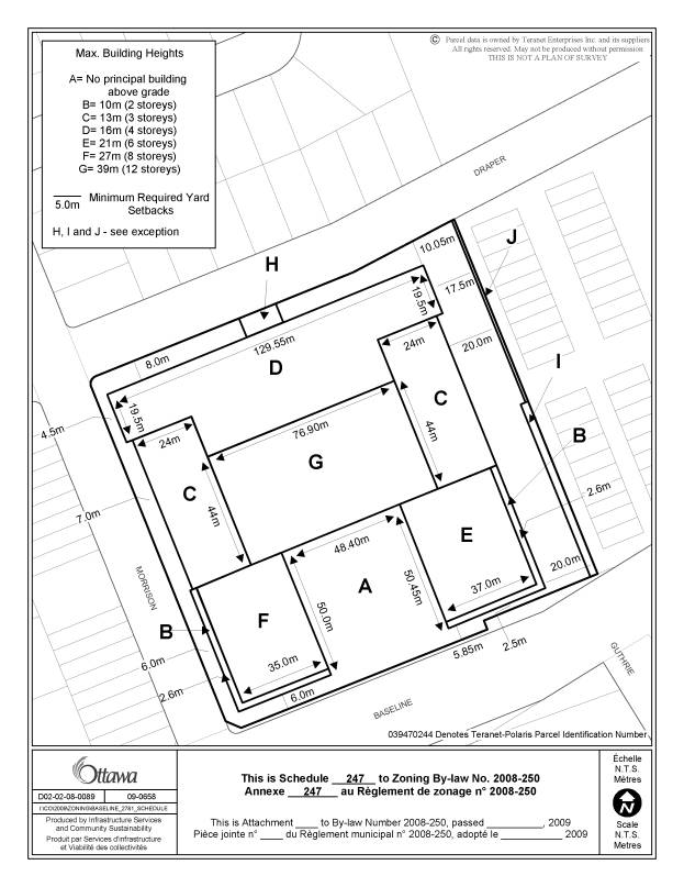
The site is zoned R4N which permits apartment buildings up to four storeys in height. Staff are recommending that the site be rezoned to R5A[1700]S247–h, which permits various forms of housing including ground oriented multiple attached, low and mid-high apartment buildings and retirement homes. As part of the rezoning proposal, staff are recommending certain modifications to performance standards to ensure the site is developed as proposed. As shown on the proposed zoning schedule, Document 4, specific height limits are being applied to permit only higher profile buildings in the southern half of the site with the 12-storey only being permitted in the centre portion of the plan. The proposed yards will offer ample separation from adjacent uses and for the most part are actually in excess of the existing minimum. The minimum width of a required landscape buffer is being modified in two locations. In Area H as shown in Document 4, the landscape buffer adjacent to Draper Avenue will be reduced to 0.3 metres for a small portion of the street frontage to permit a small visitor parking area. Area J on Document 4 is an existing 0.95 metre wide landscape buffer between an existing 24-space parking lot and an existing townhouse development located to the east at 2682 to 2700 Draper Avenue. As the parking lot is going to remain to serve the adjacent development, an exception is required to recognize the narrower landscape strip in this location. An exception is also being recommended to recognize/legalize the 24-space parking lot, which provides parking for an off-site development. The proposal exceeds the current Zoning By-law requirement for landscape open space and required parking spaces.
A Holding provision (h) is being applied which will not be lifted until a Site Plan has been submitted and approved by the City. The purpose of this is to ensure staff are satisfied with the proposed design of the buildings, in particular of the two apartment buildings located adjacent to Baseline Road at the southern corners of the plan (Buildings F and G). Similar to the way the building facades of stacked units and the four-storey apartment buildings on the northern end of the site relate well to the lower profile existing residential development nearby, staff want to ensure a similar treatment is applied to Buildings F and G. The design of these buildings must be done in such a way that they will integrate into the neighbourhood fabric. It will be important that these buildings have a residential character, which relate well to the sidewalk and have a high degree of articulation in the facades in order to enhance the pedestrian landscape along Baseline Road and Morrison Drive. If this is accomplished, it will assist in providing a better transition between the higher profile buildings and existing adjacent lower profile development and will ensure the development is visually pleasing and well connected to the public realm.
Staff supports the Zoning By-law amendment application as it advances residential and other key policies in the Official Plan and provides for a compatible residential infill development for the neighbourhood. It will allow for the construction of a variety of housing of mixed height and density on a site where the existing dwellings have reached the end of their life span and the local infrastructure can support higher density infill thus achieving an efficient use of land and resources.
CONSULTATION
Notice of this application was carried out in accordance with the City's Public Notification and Consultation Policy. The Ward Councillor is aware of this application and the staff recommendation. Numerous comments have been received from the public. The issues can be summarized as follows: building height and massing, shadowing and increased traffic. Details of the notification and consultation process are highlighted in Document 5.
LEGAL/RISK MANAGEMENT IMPLICATIONS
It is anticipated that if this matter were appealed to the Ontario Municipal Board, a three-day hearing would be required. If the staff recommendation were adopted, then external planning resources would not be required. If Council refuses the amendment, then it will be necessary to retain an outside planner at an estimated cost of $20,000 to $30,000
If this matter is appealed to the Board, whether after an adoption or a refusal, it is likely that the preparations for the hearing and possibly the hearing itself would take place while appeals to the comprehensive zoning by-law are before the Board. Therefore, it is likely that external legal services would need to be retained. The estimated cost is $30,000.
FINANCIAL IMPLICATIONS
APPLICATION PROCESS TIMELINE STATUS
The application was not processed by the "On Time Decision Date" established for the processing of Zoning By-law amendments application as a result of the need for a public meeting and the need to address community concerns. The application was placed on hold due to changes in the proposal that resulted in additional submissions and review.
SUPPORTING DOCUMENTATION
Document 1 Location Map
Document 2 Conceptual Site Plan
Document 3 Details of Recommended Zoning
Document 4 Proposed Zoning Schedule
Document 5 Consultation Details
DISPOSITION
City Clerk and Solicitor, Legislative Services, to notify the owner/agent/applicant.
Planning and Growth Management to prepare the implementing by-law, forward to Legal Services and undertake the statutory notification.
Legal Services to forward the implementing by-law to City Council.
LOCATION MAP DOCUMENT 1

CONCEPTUAL SITE PLAN DOCUMENT 2
DETAILS OF RECOMMENDED ZONING DOCUMENT 3
1. The subject property as shown on Document 1 will be rezoned from R4N to R5A[1700]S247-h.
2. A new exception will be added to Section 239 including the following zone provisions:
- Minimum required yard setbacks as shown on Schedule 247.
- Maximum permitted building heights as shown on Schedule 247.
- In Area “H” Schedule 247, the minimum required width of a landscaped buffer for a parking lot containing 10 or fewer spaces abutting a street is 0.3 m metres.
- In Area “I” on Schedule 247, the minimum required width of a landscape buffer is 3.0 metres.
- In Area “J” on Schedule 247, the minimum required width of a landscape buffer is 0.95 metres.
- 24 parking spaces for the property located at 2690 to 2700 Draper Avenue inclusive, are permitted.
- The removal of the “h” symbol is conditional on the submission and approval of a site plan.
3. Part 17 – Schedules will be amended by adding Document 4 as a new Schedule.
PROPOSED ZONING SCHEDULE DOCUMENT 4
CONSULTATION DETAILS DOCUMENT 5
NOTIFICATION AND CONSULTATION PROCESS
Notification and public consultation was undertaken in accordance with the Public Notification and Public Consultation Policy approved by City Council for Zoning By-law amendments. The Ward Councillor also held a public meeting in the community on October 2, 2008.
SUMMARY OF PUBLIC INPUT
Extensive comments were received from the public and from the public meeting regarding this application when it was originally circulated. At that time, the application proposed 537 units and a 20-storey apartment building. Following the public meeting, the applicant submitted a revised proposal. Staff circulated the revised proposal and fewer comments were received, but the concerns identified were the same.
The following contains a summary of concerns and questions raised by the community:
(1) Concern was raised by the community of the level of intensification proposed for the site. Specifically that this proposal seems to propose too much density.
Staff Response:
The proposal conforms with and implements the general policies of the Official Plan. The Official Plan encourages intensification on land designated General Urban Area to effectively use land and resources. Given the property’s location on the edge of a neighbourhood and adjacent to an arterial and a collector road, the level of intensification is seen as appropriate.
(2) Traffic Volumes – During the public open house held in October, 2008, the community raised concerns that traffic counts were undertaken during the summer time and did not reflect congestion along Morrison Drive corridor to the north of the proposed development nor major arterial roadways.
Staff Response:
Morrison Drive is a minor collector, which “serves neighbourhood travel between local and major collector or arterial roads (Baseline) and provides direct access to adjacent lands.”
The traffic consultant undertook
addition traffic counts in the fall of 2008 during the weekdays while the
adjacent schools were active and the January traffic counts were undertaken
during the OC Transpo transit strike.
The updated traffic information collected indicated traffic volumes were
indeed higher than those obtained during the summer months of 2007. However, the traffic analysis indicates that
traffic along the Morrison Drive corridor continues to operate with satisfactory
levels of service. The revised site
plan in comparison to the original concept was found to generate approximately
17 vehicles per hour less traffic. The
conclusion reached in the original Transportation Impact Assessment document
remains the same in that “the proposed redevelopment of the residential site
was determined to be negligible.” As traffic distributes itself throughout the
available roadways within the area, the traffic generated by the site was found
not to result in any significant impact to the operational performance of major
intersections and can accommodate the proposed redevelopment.
(3) Pedestrian Facilities – Residents expressed concerns regarding the need for a continuous sidewalk corridor within the community.
Staff Response: The proposed site plan provides for a continuous sidewalk surrounding the complete periphery of the development.
(4) There will be a significant load on the existing services (i.e., water, sewer, storm water services) due to this development.
Staff Response: The existing services in the area have been evaluated by City staff and it has been determined that there is adequate capacity for the needs of the proposal in the sewers serving the site. With respect to the watermain, with the addition of domestic booster pumps there will be adequate water pressure for the top floors of the apartment buildings and the proposed development can be adequately serviced with the existing watermain distribution network.
(5) Will the development be owner-occupied or rental?
Staff Response:
The applicant is proposing the project to be a condominium. The City cannot control the tenure of the property.
(6) What will happen to the existing tenants?
Staff Response:
Under the Provincial Residential Tenancies Act, 2006, a landlord may give notice of termination of a tenancy if the rental unit is to be demolished as part of a redevelopment. The date for termination specified in the notice shall be at least 120 days after the notice is given and shall be the day a period of the tenancy ends or, where the tenancy is for a fixed term, the end of the term. In the case of a demolition involving a residential complex of five or more units, as is the case with this application, a landlord shall compensate a tenant in an amount equal to three months rent or offer the tenant another rental unit acceptable to the tenant.
The applicant has indicated that a “first right of refusal” to purchase one of the new condominium units will be offered to the existing tenants.
(7) Property values may drop as a result of this development.
Staff Response:
The Department does not have any evidence that intensification of this sort has any correlation with the devaluation of property values. Property values are based on a number of qualitative and quantitative factors, of which Zoning By-law Amendments and new development are one.
(8) How much green space is proposed for the new development and what will happen to the existing mature trees surrounding the site?
Staff Response:
Most of the parking will be located in a below grade garage, which frees up more surface area for greenspace. The Zoning By-law requires a minimum of 35 per cent landscaped open space. The proposed concept plan provides 45.2 per cent. The site has many mature trees, many of which are coniferous, bordering the site along the street frontages. It is proposed that the majority of these trees will be preserved, as they are a benefit to both the site and the public because they contribute to the character of the area and will continue to provide a substantive vegetation buffer zone for the residential area immediately adjacent to the property.
(9) Nearby residents are concerned of shadows from the proposed apartments buildings.
Staff Response:
The applicant has emphasized the minimizing of visual and shadow impact on the existing neighbourhood by strategically positioning the high rise apartment building in the centre area of the site and the two mid-rise apartment buildings adjacent to Baseline Road. Furthermore, the apartment building proposed for the south east corner of the property which is located closest to existing housing has been decreased in height from 12 stories to six. The shadow studies for the December 21st scenario indicate that estimated shadows have a minor effect on the front yards of the housing on Draper Avenue and on the rear yards of the existing housing to the east.
(10) Concerns have been expressed that views from their homes will be blocked and there will be too much building massing.
Staff Response:
The view of the development from adjacent areas will be that of the central 12-storey building that is surrounded with lower buildings, with the entire project set behind stands of existing and new trees to be planted along the edge of the property. The proposed buildings have been sited and oriented to provide proper separation distances between the buildings within the property and generous separation distances to the adjacent development. The design of the buildings presents a variety of forms and scales, with certain elements e.g. corner windows and roofscapes that lend variety to the project.