Report to/Rapport au :
Planning and
Environment Committee
Comité de l'urbanisme et de l'environnement
and Council / et au Conseil
17 March 2010/le 17 mars 2010
Submitted by/Soumis
par : Nancy Schepers, Deputy City Manager/Directrice
municipale adjointe,
Infrastructure Services and Community
Sustainability/Services d’infrastructure et Viabilité des collectivités
Contact
Person/Personne-ressource : Michael Wildman, Manager/Gestionnaire, Development
Review-Suburban Services/Examen des projets d'aménagement-Services suburbains,
Planning and Growth Management/Urbanisme et Gestion de la croissance
(613) 580-2424,
27811 Mike.Wildman@ottawa.ca
|
SUBJECT: |
zoning
- 6151 renaud road (file no. D02-02-03-0072) and 6255 Renaud Road (File
no. d02-02-03-0073) |
|
|
|
|
OBJET : |
REPORT RECOMMENDATION
That Planning and Environment
Committee recommend Council approve:
1.
An amendment to Zoning By-law 2008-250 to change
the zoning of parts of 6151 Renaud Road and 6255 Renaud Road from DR
Development Reserve to R3YY[x],
Residential Third Density, Subzone YY, Exception
[x] and Parks and Open Space [O1] as shown in Document
1 and as detailed in Document 2.
2.
An amendment to Zoning By-law 2008-250 to change
the zoning of part of 6151 Renaud Road from DR Development Reserve to
Residential Third Density, Subzone Z, Exception [x1], [x2], and [x3] Zones, R3Z[x1], R3Z[x2] and R3Z[x3] and Parks and Open Space [O1] as shown in
Document 1 and as detailed in Document 2.
RECOMMANDATION DU RAPPORT
Que le Comité de recommande
au Conseil d’approuver :
1.
une modification au Règlement municipal 2008-250, visant à modifier le
zonage de parties du 6151, chemin Renaud et du 6255, chemin Renaud de DR (Zone
d'aménagement futur) à R3YY[x] (Zone résidentielle de densité 3,
sous-zone YY, assortie d’une exception
[x]) et à O1 (Zone de parc et d'espace vert), comme il est indiqué dans le
document 1 et expliqué en détail dans le document 2;
2.
une modification au Règlement municipal 2008-250, visant à modifier le
zonage d’une partie du 6151, chemin Renaud de DR (Zone d'aménagement futur) à
R3Z[x1], R3Z[x2] et R3Z[x3] (Zone résidentielle de densité 3, sous-zone Z, assortie d’exceptions [x1],
[x2] et [x3]) et à O1 (Zone de parc et d'espace vert), comme il est
indiqué dans le document 1 et expliqué en détail dans le document 2.
BACKGROUND
The subject property is bounded to the north
generally by the Hydro Corridor, to the south by Navan Road/Renaud Road, to the
west by residential development and by vacant development land to the east.
This site is the western portion of the future TrailsEdge Subdivision.
The subject land is characterized as an undeveloped area. The western portion, under the ownership of Richcraft, encompasses approximately 6.45 hectares with approximately 20 metres frontage along Page Road, 37 metres along Navan Road and 31 metres of broken frontage along Renaud Road. The second portion immediately located to the east and owned by Minto, encompasses an area of approximately 14.3 hectares with 20 metres frontage along Renaud Road. Primary access to the site will be provided from Page Road and Renaud Road with a number of local roads to be created to provide access to individual lots. A future access to Navan Road will be provided once the intersection of Navan, Page and Renaud Roads is reconfigured.
Purpose of Zoning Amendment
The applicants are proposing to amend the Zoning By-law to implement residential zones which will permit detached and multiple attached dwellings. The new zoning would conform to the lot and road pattern outlined in the Draft Plans of Subdivision filed by Richcraft approved on April 29, 2009 and Minto approved January 13, 2010.
The Richcraft proposal consists of 64 lots for detached dwellings and three blocks for 36 multiple attached dwellings. The plan also proposes 11 partial lots for detached dwellings and one partial block for 22 multiple attached dwellings. These partial lots and blocks will be subject to an inhibiting order through the subdivision which will delay development on these lands until such time as they are consolidated with the appropriate lot and block on lands to the east currently owned by Minto. The Minto portion consists of 10 blocks for multiple attached dwellings and one for detached dwellings. The subdivisions also include lands to be dedicated to the City for the Transitway Corridor, Blackburn Hamlet Bypass, stormwater management pond 1, walkways and streets.
The Zoning By-law zones the lands DR (Development Reserve), which recognizes lands intended for future urban development in areas designated as General Urban Area.
The purpose of the Zoning By-law amendment is to permit the construction of detached dwellings and multiple attached dwellings in accordance with the Draft Plans of Subdivision. The proposed zoning amends development requirements in relation to front and rear yard setbacks in order to ensure the adequate provision for trees in the front yard and a reduction in the corner side yard setback.
DISCUSSION
The Official Plan designates the area as Developing Community and General Urban Area. The Developing Community designation identifies parts of the city that are underdeveloped or substantially underdeveloped and are intended to offer a full range of housing choice, commercial, institutional and leisure activities with a development pattern which places priority on walking, cycling and transit over automobiles. In this regard, the East Urban Community Design Plan (CDP) identifies lands for medium-low density residential development. The CDP also requires an Urban Natural Areas Environmental Evaluation Study for the subject lands.
The General Urban Area designation permits a full range of types and densities of housing to meet the needs of all ages, incomes and life circumstances, including low, medium and high density housing and seniors’ apartments, in combination with well located employment, shopping, service, cultural, leisure, park, natural areas and institutional uses to facilitate the development of complete and sustainable communities. The proposed detached and multiple attached dwellings are residential uses permitted within this designation.
The Development Reserve Zone of the Zoning By-law recognizes that the subject lands are intended for future development. The proposed subdivision is adjacent to established residential development along Page Road and will form part of a larger community as the lands to the east are developed. The street layout services the proposed development and provides for the logical expansion into abutting lands for future development.
The proposed zoning for these subdivisions conforms to the proposed development as shown on the draft plans of subdivision. The zoning makes use of the existing Residential Third Density zone within the Zoning By-law, indicating that the general form of development has been previously contemplated and considered appropriate. Modifications are proposed to amend specific front and rear yard setbacks and to decrease corner side yard setbacks for a portion of the subdivision as it relates to detached, linked detached, semi-detached and multiple attached dwellings. These modifications are appropriate to the form and function of the development and should not raise concerns with respect to the impact on abutting properties.
The increase in front yard setback will permit
the planting of street trees with an adequate setback, given the presence of
sensitive marine clay on the site. The normal separation distance between a
tree and structure is 7.5 metres, with an additional 1.5-metre separation
distance required from the curb. Given the 16.5-metre road width of one of the
proposed streets, it is not possible to plant a street tree which meets the
setback constraints. In discussion with Forestry staff, in order to accommodate
trees without increasing the required front yard setback and thereby reducing
the rear yard setback, root barriers will be utilized. These barriers, once
installed between the building and tree root, are intended to direct the roots
away from building foundations and will decrease the required separation
distance to a building to 5.0 metres. The site specific setback requirements
reflect the minimum front yard and resulting rear yard required in order to
accommodate this situation. These setbacks continue to provide adequate amenity
area in the rear yard.
The reduction in the corner side yard setback
has been used in other areas of the city and is appropriate for urban development.
A reduction does not impact on the daylighting triangle or the functioning of
the intersection. The reduction creates a street environment as envisioned by
the CDP by bringing the house and porch closer to the property line.
The zoning proposed on the partial blocks and
lots correspond across the property lines. Inhibiting orders will be placed on
their development until such time as the partial lots are merged to form
developable lots.
The lands to be conveyed from the Owner to the
City through the subdivision agreement for stormwater management and Transitway
purposes will be zoned Parks and Open Space, [O1]. This continues the zoning of
lands for similar uses to the west. These lands are located to the north of the
proposed residential development.
ENVIRONMENTAL
IMPLICATIONS
This area has been identified in the East Urban Community Design Plan as an area requiring an Urban Natural Areas Environmental Evaluation Study. To this end, the following is a condition of both draft plans of subdivision that will be required to be satisfied prior to the registration of the Subdivision Agreements:
The Owner agrees to prepare and implement an "Integrated Environmental Review Statement" as set out in the Official Plan prior to registration demonstrating how all the studies in support of the application influence the design of the development with respect to the effects on the environment.
RURAL IMPLICATIONS
N/A
CONSULTATION
Notice of this application was carried out in accordance with the City's Public Notification and Consultation Policy. The City did not receive any public comments related to this application.
FINANCIAL IMPLICATIONS
COMMENTS BY THE
WARD COUNCILLOR
The Ward Councillor is aware of this application and the staff recommendation.
LEGAL/RISK MANAGEMENT
IMPLICATIONS
There are no legal/risk management implications associated with this report.
CITY STRATEGIC PLAN
In accordance with the City Strategic Plan, this development respects the existing urban fabric and the infrastructure required for the growth is available or will be available to serve the development.
TECHNICAL
IMPLICATIONS
N/A
APPLICATION PROCESS
TIMELINE STATUS
The application was not processed by the "On Time Decision Date" established for the processing of Zoning By-law amendments due to the concurrent review of the subdivision application.
SUPPORTING DOCUMENTATION
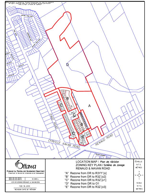
Document 1 Location Map
Document 2 Details of Recommended Zoning
DISPOSITION
City Clerk and Solicitor Department, Legislative Services to notify the owner/applicant, OttawaScene.com, 174 Colonnade Road, Unit #33, Ottawa, ON K2E 7J5, Ghislain Lamarche, Program Manager, Assessment, Financial Services Branch (Mail Code: 26-76) of City Council’s decision.
Planning and Growth Management Department to prepare the implementing by-law, forward to Legal Services Branch and undertake the statutory notification.
Legal Services Branch to forward the implementing by-laws to City Council.
LOCATION MAP DOCUMENT
1
DETAILS OF RECOMMENDED ZONING DOCUMENT 2
A. Zoning By-law 2008-250
1. The zoning map of the Comprehensive City of Ottawa Zoning By-law will be amended by changing the zoning for the subject properties from Development Reserve (DR) to R3YY[x], R3Z[x1], R3Z[x2], R3Z[x3] and O1 as shown on Document 1.
2. A new exception will be added to Section 239-Urban Exceptions, and the following special provision will apply to land zoned R3YY[x]:
Despite Table 160A:
i) minimum corner side yard setback for detached, linked detached, semi-detached and multiple attached dwellings 3 metres
3. A new exception will be added to Section 239-Urban Exceptions, and the following special provision will apply to land zoned R3Z[x1]:
Despite Table 160A:
i) minimum front yard setback 5.25 metres
ii) minimum rear yard setback 6 metres
4. A new exception will be added to Section 239-Urban Exceptions, and the following special provision will apply to land zoned R3Z[x2]:
Despite Table 160A:
i) minimum front yard setback 4.5 metres
ii) minimum rear yard setback 5.5 metres
5. A new exception will be added to Section 239-Urban Exceptions, and the following special provision will apply to land zoned R3Z[x3]:
Despite Table 160A:
i) minimum front yard setback 6.9 metres
ii) minimum rear yard setback 6 metres
It is requested that two
separate by-laws be prepared: One for the zone amendments from DR to R3Z[x1],
R3Z[x2] and R3Z[x3]
and a second by-law for the amendments from DR to R3YY[x] and O1.