Report to/Rapport au :
Planning and Environment Committee
Comité de l'urbanisme et de l'environnement
and Council / et au Conseil
08 April 2010 / le 08 avril 2010
Submitted by/Soumis par : Nancy Schepers, Deputy City Manager/Directrice municipale adjointe, Infrastructure Services and Community Sustainability/Services d’infrastructure et Viabilité des collectivités
Contact Person/Personne-ressource : Richard Kilstrom, Acting Manager/Gestionnaire intérimaire, Development Review-Urban Services, Inner Core/Examen des projets d'aménagement-Services urbains, Unité du Centre intérieur
Planning and Growth Management/Urbanisme et Gestion de la croissance
(613) 580-2424, 22379 Richard.Kilstrom@ottawa.ca
|
SUBJECT: |
|
|
|
|
|
OBJET : |
REPORT RECOMMENDATIONS
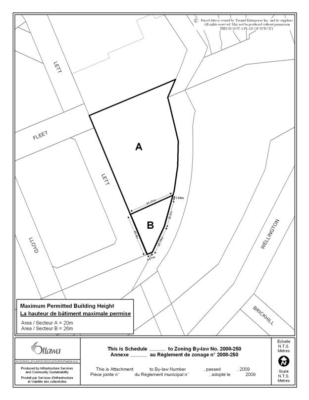
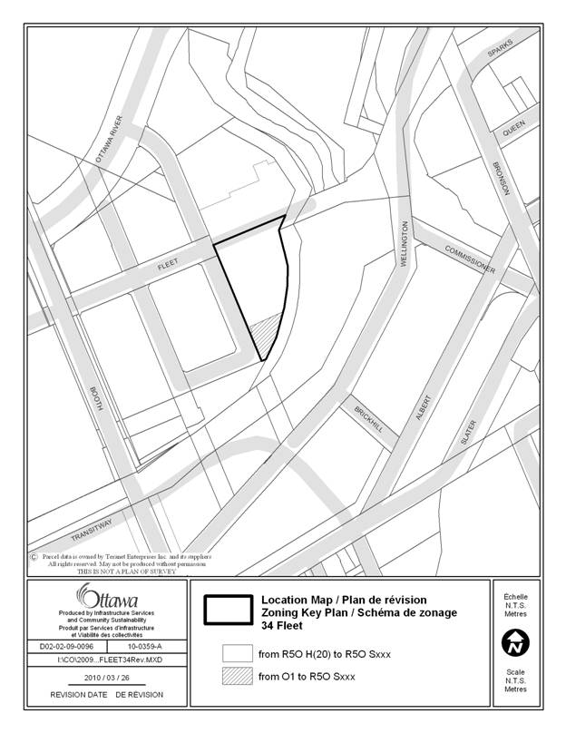
That the recommend Council approve an amendment to the City of Ottawa Zoning By-law to change the zoning of 34 Fleet Street from Open Space (O1) and Residential Fifth Density (R5O H(20)) to a new Residential Fifth Density zone with a height schedule (R5O Sxxxx), to permit a high-rise apartment building, as shown on Document 1 and as detailed in Document 2.
RECOMMANDATIONS DU RAPPORT
Que le Comité de l'urbanisme et de l'environnement recommande au Conseil d’approuver une modification au Règlement de zonage de la Ville d’Ottawa visant à changer la désignation de zonage actuelle de la propriété située au 34, rue Fleet, soit zone d’espace vert (O1) et zone résidentielle de densité 5 (R5O H(20)), et à la remplacer par une nouvelle désignation, soit zone résidentielle de densité 5 assortie d’une annexe portant sur la hauteur des constructions (R5O Sxxxx), afin de permettre un immeuble d’habitation de grande hauteur, comme l’illustre le document 1 et le précise le document 2.
BACKGROUND
The subject lands are located in LeBreton Flats, south of the Fleet Street Mews, east of Lett Street and west of the public lands running parallel to the Aqueduct. The lands are currently vacant and are triangular in nature. They comprise Block 2 on the approved plan of subdivision for this portion of LeBreton Flats. The subject property is currently dual zoned, with the majority of the site being zoned residential and a small portion at the southerly tip being zoned for open space. The applicant is proposing two amendments to the City's Zoning By-law. The first is to amend the zoning so that the entirety of the property they own is zoned for residential purposes and the second is to increase the height limit on the lands generally being rezoned, from 20 to 26 metres.
DISCUSSION
RELOCATION OF ZONING LINE
Zoning as Open Space
Prior to 1998, the Zoning By-law of the former City of Ottawa, (Z-2K) zoned the entirety of Block 2 as Government (G). This zoning line ran parallel to the Aqueduct, with the lands on the south side of the Aqueduct being zoned Residential Office (RO). This zoning remained in place until 1998, when the majority of the lands forming Block 2 were zoned to Residential (R6K) and the southern portion was zoned to Leisure (L2B). This dual zoning has been carried over into the City's new Zoning By-law, which zones the majority of the land as Residential (R5O H20), with the leisure zoning becoming Open Space (O1). There is no supporting planning rationale for the change in the location of the zoning line in 1998. As the City's new Zoning By-law followed the zoning boundary established at that time, the line appears to have been drawn arbitrarily.
Subdivision and Official Plan
When the Plan of Subdivision was approved, it provided for Blocks of open space to be dedicated to the City along the Aqueduct, as well as to the south of Block 2, west to Booth Street. It did not foresee the southern tip of Block 2 being used for open space. The Blocks of Land, which were reserved for Open Space, were approved to meet the policies of the LeBreton Flats Character Area, which require a minimum of five metres of open space between the fence line along the Aqueduct and adjacent properties. The Blocks of land along the Aqueduct, which are dedicated for open space, are a minimum of 10 metres wide and up to approximately 38 metres in width. The lands provided as open space in the approved subdivision are adequate to meet the goals of the Greenway System policies in the Central Area Secondary Plan for the LeBreton Flats Character Area. The land owned by the applicant is not needed to meet established open space requirements.
Design Guidelines
As part of the Development of LeBreton Flats, the National Capital Commission prepared Private Development Design Guidelines, to help govern not only the massing and height of buildings but also the distance between buildings and the amount of open space on a parcel of land. For the subject property, the area presently zoned as open space is indicated as being occupied by a building having a minimum height of four storeys. It is not shown as being landscaped area.
From the foregoing, it can be concluded that the southern tip of Block 2 has been inadvertently zoned as open space and the rezoning of the land to residential will not negatively affect the provision of open space in LeBreton Flats nor the intent of the City's Official Plan or the National Capital Commission's Design Guidelines.
INCREASE IN HEIGHT
In addition to rezoning the southern tip of Block 2 as residential, the applicant is also requesting that the lands generally to be rezoned from Open Space, also have a permissible height of 26 metres. The remainder of the property presently has a height of 20 metres. The proposed height increase will allow for two additional storeys, beyond what is presently allowed by the City's Zoning By-law. While it can be argued that the additional two storeys will allow for an increase in residential units, which meets the City's Official Plan policies related to intensification, the increase in height will also provide the opportunity for a more compatible and varying design. This is appropriate because Block 2 is a large site having a frontage of approximately 111 metres along Lett Street. A building with a uniform height of six storeys along this frontage would create a wall along the street and with the future development of Block 3, which is opposite the site, having the same height limit; this wall effect would be amplified. Instead, the proposed increase in height will add a variation to the design of the building and a variation to the streetscape. This in turn will create a better built form and development profile, which will add to the character of LeBreton Flats.
It is also the Department's opinion that since the proposed height increase is only being applied to a small portion of the property, it does not conflict with the intended intensity of development for this portion of LeBreton Flats, as identified in the private development design guidelines, the City's Official Plan and the Zoning By-law. It also does not conflict with the Vistas and Views to the Parliament Buildings. As a result, the Department is recommending approval of this rezoning request.
ENVIRONMENTAL IMPLICATIONS
Site contamination issues have been addressed through the complementary subdivision approval.
RURAL IMPLICATIONS
CONSULTATION
Notice of this application was carried out in accordance with the City's Public Notification and Consultation Policy. The City received one comment questioning whether changes should be made to the Overall Master Development Plan for LeBreton Flats. It is the Department’s position that the amendments are minor and do not negatively effect the Master Development plan for LeBreton Flats.
COMMENTS BY THE WARD COUNCILLOR(S)
Councillor Diane Holmes is aware of this application.
LEGAL/RISK MANAGEMENT IMPLICATIONS
There are no legal/risk management implications associated with this report.
CITY STRATEGIC PLAN
F2 – Respect the existing urban fabric, neighbourhood form and the limits of the existing hard services, so that new growth is integrated seamlessly with established communities.
TECHNICAL IMPLICATIONS
N/A
FINANCIAL IMPLICATIONS
N/A
APPLICATION PROCESS TIMELINE STATUS
This application was not processed by the "On Time Decision Date" established for the processing of Zoning By-law amendment applications as a result of the need to review elevations of the proposed buildings, in relation to the requested height increase.
SUPPORTING DOCUMENTATION
Document 1 Location Map
Document 2 Zoning Height Schedule
DISPOSITION
City Clerk and Solicitor Department, Legislative Services to notify the owner, applicant, OttawaScene.com, 174 Colonnade Road, Unit #33, Ottawa, ON K2E 7J5, Ghislain Lamarche, Program Manager, Assessment, Financial Services Branch (Mail Code: 26-76) of City Council’s decision.
Planning and Growth Management to prepare the implementing by-law, forward to Legal Services and undertake the statutory notification.
Legal Services to forward the implementing by-law to City Council.
LOCATION MAP DOCUMENT 1
ZONING HEIGHT SCHEDULE DOCUMENT 2