Report to/Rapport au :
Planning and Environment Committee
Comité de l'urbanisme et de l'environnement
and Council / et au Conseil
09 April 2010 / le 09 avril 2010
Submitted by/Soumis par : Nancy Schepers, Deputy City Manager/Directrice municipale adjointe, Infrastructure Services and Community Sustainability/Services d’infrastructure et Viabilité des collectivités
Contact Person/Personne-ressource : Richard Kilstrom, Acting Manager/Gestionnaire intérimaire, Development Review-Urban Services, Inner Core/Examen des projets d'aménagement-Services urbains, Unité du Centre intérieur
Planning and Growth Management/Urbanisme et Gestion de la croissance
(613) 580-2424, 22379 Richard.Kilstrom@ottawa.ca
|
SUBJECT: |
|
|
|
|
|
OBJET : |
REPORT RECOMMENDATIONS
That the recommend Council refuse an amendment to the Zoning By‑law 2008‑250 and former City of Ottawa By-law 93-98 to change the zoning of 801 Albert Street to permit a mixed-use development.
RECOMMANDATIONS DU RAPPORT
Que le Comité de recommande au Conseil de refuser d’apporter une modification au Règlement 2008-250 sur le zonage et au Règlement 93-98 de l’ancienne Ville d’Ottawa afin de changer le zonage du 801, rue Albert, de façon à y permettre un aménagement polyvalent.
BACKGROUND
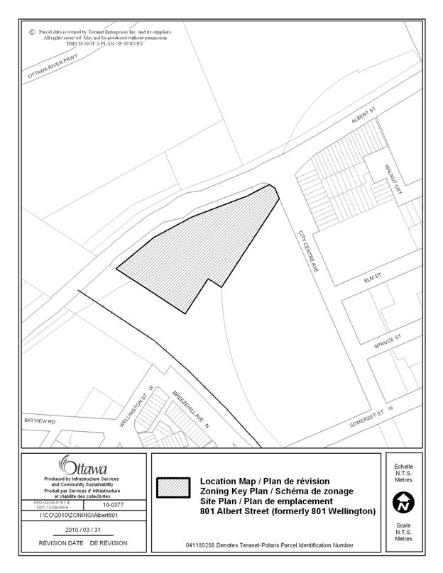
The subject property is a triangular piece of vacant land approximately 1.44 hectares in size. The property is located immediately south west of the intersection of Albert Street (formerly Scott Street) and City Centre Avenue (formerly Champagne Avenue). The site is bound on the west by the CP Rail/O-Train tracks, on the north by Albert Street and on the south and east by the City Centre development. The property has frontage on both Albert Street and City Centre Avenue. The O-Train platform and the Bayview bus station are located approximately 140 metres from the signalized crossing on Albert Street along the northern limit of the property.
The property is located at the northern edge of an area designated as a Mixed-Use Centre in the Official Plan that extends from the subject site to Carling Avenue along the O-Train Corridor, and that is currently subject to a community design plan (CDP) process. It is therefore recognized as a site offering potential for contributing to achieving the City's intensification objectives through compact mixed-use development focused on the City's transit system. Determination of the nature and intensity of development for all lands within the CDP area is intended to be completed through the CDP process. At the same time, the site has some significant constraints to achieving the nature and form of development contemplated for mixed-use centers. These constraints include the major infrastructure that serves large areas of the city (the West Nepean Collector Sanitary Sewer, the Mooney's Bay Collector Sanitary Sewer, the Nepean Bay Storm Sewer and a major High Pressure Transmission Main) crossing the site, as well as access constraints as a result of the characteristics and conditions of adjacent roads. The presence of this infrastructure and the related easements in place in favour of the City of Ottawa create portions of the site which are not developable at this time, and also limit the current options for access to the site. In recognition of the current constraints on the site, the zoning established for the site to implement its inclusion in the Mixed-Use Centre designation put in place through By-law 2008-250, holding provisions exists which prevent development from proceeding until such time that as following matters have been addressed:
i) a Master Servicing Study to confirm the water, sewer and storm sewer service infrastructure requirements, including main trunk lines;
ii) the High Pressure Transmission Main crossing the site has been replaced;
iii) a comprehensive Traffic Impact Analysis has been completed that will address the surrounding area traffic issues and the property’s vehicle access and egress requirements; and,
iv) Site Plan approval has been issued.
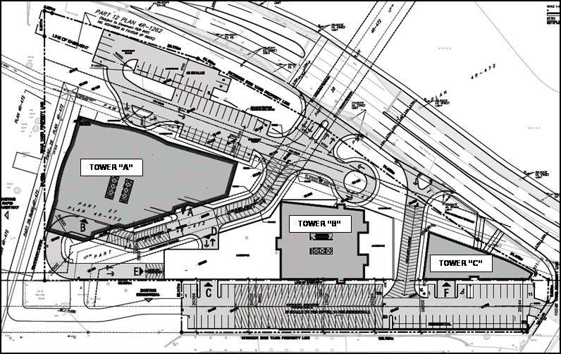
With respect to the above conditions, it is the applicant’s position that the current concept, as shown on Document 2, is not located within or built-over any of the major infrastructure easements. The High Pressure Transmission Main on the southern portion of the site has in fact been replaced. The applicant has prepared a Traffic Impact Analysis in support of their applications, and has submitted an application for Site Plan Control that is currently under review.
Purpose of Zoning Amendment
The application proposes a change in zoning to facilitate the construction of a mixed-use, multiple building development on the subject lands. The development would consist of a new office tower (Tower A), a new residential tower (Tower B), and a third smaller mixed-use building (Tower C) as shown on Document 2. The office tower would be 17 stories in height with approximately 37,632 square metres of gross floor area, with a total of 378 surface and structured parking spaces. The 378 parking spaces would be located within a podium, the top of which would be level with Albert Street and serve as the base for the tower. The residential tower would be 24 storeys in height with 184 dwelling units. The residential tower would have four storeys of structured parking totalling 219 spaces. This structured parking, located below the tower would result in the base of the tower being roughly level with the elevation of Albert Street. The smaller mixed-use building on the eastern portion of the site would be four storeys in height. The ground floor would consist of commercial uses, with the remaining three floors consisting of 15 residential units. Eight indoor parking spaces would be provided for these residential units.
The primary access to the site would be from Albert Street at a fully signalized intersection. A secondary right-in right-out only access is proposed from Albert Street with a third access proposed from City Centre Avenue. Surface parking would be located between Towers A and B and Albert Street and on the southern portion of the property.
By-law 2008-250
The subject property is currently zoned “Mixed-Use Centre, Exception Zone”, MC[1351] F(1.5)‑h. The Mixed-Use Centre zone accommodates a combination of transit-supportive uses such as offices, hotels, hospitals, community recreation and leisure centres, retail uses, service uses such as restaurants and personal service businesses, and high and medium-density residential uses. The current Mixed-Use Centre Exception Zone permits a floor space index of 1.5, and is subject to holding provisions previously mentioned.
The applicant has appealed the provisions of By-law 2008-250 as they apply to the subject site. A hearing to deal with this appeal is scheduled for May 11, 2010. The applicant has also through the zoning amendment application, requested that the holding provisions of the zoning be lifted and that further modifications be made to accommodate the proposed development.
Former City of Ottawa By-law 93-98
As a result of the applicant’s appeal to the provisions of By-law 2008-250, the zoning applicable to the site under the former City of Ottawa Zoning By-law 93-98 remains in place until such time as the appeal has been dealt with to provide for final approval of the zoning put in place by By‑law 2008-250.
Under former By-law 93-98, the subject lands are zoned “General Industrial, Exception Zone” IG[695] F (1.0). This exception zone allows a maximum floor space index of 1.0 for the site. The IG zone does not permit the mixed-use development requires for areas designated Mixed-Use Centre under the Official Plan. The applicant, given that the zoning under By-law 2008-250 is not in full force and effect, is also requesting that the zoning under former By-law 93-98 be modified to permit the proposed mixed-use development.
By-law 2008-250
The application proposes a change in zoning to “Mixed-Use Centre, Exception Zone” MC[****]. The proposed zone would remove the current holding symbol and provisions, along with the floor space index. As well, the exception zoning would permit a site-specific ratio for office parking of 0.75 spaces per 100 square metres of gross floor area whereas the By-law requires 1.8 spaces per 100 square metres of gross floor area.
Former City of Ottawa By-law 93-98
The application proposes a change in zoning to “General Commercial Exception Zone” CG. The exception zone would carry forward the site-specific parking ratio noted above.
History of Applications
The applicant first submitted applications for development of the subject property shortly after acquiring the property from the National Capital Commission in 2004. At that time, the applicant had submitted a rezoning application and a plan of subdivision to accommodate a residential development comprising an 18-storey residential tower consisting of 147 units, 32 stacked townhouses units, and 24 townhouse units located between the existing infrastructure easements. These applications were never deemed complete.
In 2005, the applicant submitted an unsolicited proposal for the site to be developed to accommodate a new main branch for the Ottawa Public Library, with some residential development. This proposal involved developing over the adjacent O-Train line to provide for integration of the Library with the then proposed North-South LRT, and also proposed to use a portion of the City-owned Tom Brown Arena lands located west of the LRT corridor. The City did not accept this unsolicited proposal. The City however, agreed to work with the applicant to determine whether there may be a potential for having the site develop in a manner that would provide for integration with the proposed North-South LRT. Towards this end, a Memorandum of Understanding was entered into and work was initiated to determine a development framework to provide for an integrated development. Guiding principles were developed and agreed to by the parties; however, the process was terminated prior to determining an implementation program as a result of the cancellation of the North-South LRT project.
In August 2007, the applicant revised its applications for a change in zoning and plan of subdivision. The modified application proposed two 19-storey residential apartment buildings with surface and underground parking. The applicant again revised its applications on January 2009 to accommodate a modified development proposal. At that time an application for Site Plan Control was submitted and the subdivision application was withdrawn. The modified proposal then called for two 31-storey residential towers consisting of 438 units and a small four-storey office building.
All of the development proposals submitted between 2007 and March of 2010 proposed building over existing infrastructure, which the City had indicated would not be accepted without a Master Servicing Study that provided for relocation of the infrastructure. Such a study was never submitted. As a result none of the applications or revisions to applications were deemed complete and were never processed to proceed for a decision to be made by Council.
In March 2010, the applicant submitted a further request to modify their applications and submitted a modified development proposal that would not require any build-over of existing infrastructure. All the required materials to allow for processing of the modified application and proposal were submitted, and the modified application was deemed complete on March 1, 2010. This final revision and associated development proposal are the subject of this report, and is being brought forward for a decision to be rendered prior to the scheduled OMB hearing to deal with the applicant’s appeal to By-law 2008-250, schedule for May 11, 2010.
DISCUSSION
Until the submission of the current development proposal and the associated revisions to the applicant’s planning applications, the applicant was proposing to develop over top of some of the City’s key infrastructure and was not respecting the existing easements protecting this infrastructure. While the City was prepared to give consideration to having some of the infrastructure relocated to unencumber the site, the City required that determinations in this regard be made through a comprehensive Master Servicing Study. With the applicant now proposing to develop the site without building over any infrastructure or without requiring relocation of infrastructure, the key engineering issues that prevented any of the previous proposals from being considered are no longer an impediment to having the applications considered on their planning merits. Towards this end, the key considerations in the review of the rezoning application relate to how the development as proposed by the applicant, does or does not respond to and/or address applicable strategic directions and policies of the Official Plan and the directions set out in the Council-approved Transit-Oriented Development and High-Rise Housing Design Guidelines.
Strategic Directions
To meet the challenge of managing growth the City will direct growth to the urban area and specifically to those areas designated as Central Area, Mixed-Use Centres, Employment Areas, Enterprise Areas, Developing Communities and Mainstreets. These areas include locations that are centred on the rapid-transit network, major roads, busy commercial streets, and large tracts of vacant land. The City will encourage a pattern and density of development that supports transit, cycling and walking as viable and attractive alternatives to the automobile. Development in these areas can strengthen the urban structure, balance housing and employment uses, and make transit provision more efficient. These areas offer substantial opportunities for new development or redevelopment and represent a key element in the Official Plan’s strategy to accommodate and direct growth in the city. Mixed-Use Centres will grow substantially, but in a way that complements the development pattern within and adjacent to them.
A key direction for areas where more intense mixed-use development is to be provided, and specifically for Mixed-Use Centres, is that they be developed as dynamic centers of activity in a way that is compact and will contribute to place-making through an urban form and organization of uses that provide for a strong pedestrian and transit orientation for the area, and provide for strong interconnections through and to adjacent areas.
The development proposed for the site under the current zoning in staff’s view is not reflective of the strategic intent of the OP for development within Mixed-Use Centres. As a result of the site’s physical condition, to the achieve development that does not impact the city’s infrastructure, the development proposed is not reaching the form and quality called for. It very much reflects a more suburban design approach of towers in a park and not the more urban interconnected pedestrian-focused development required to have the site be an integral element of the larger Mixed-Use Centre of which it is a part.
Mixed-Use Centre
The subject property and adjacent lands are designated Mixed-Use Centre on Schedule B of the Official Plan (OP). Mixed-Use Centres are strategic and critical locations along transit corridors that act as focal points of activity at the local community and regional scales. These areas have a high potential for mixed-use and compact development and are to develop as good places in their own right as components of complete neighbourhoods. Development of a Mixed-Use Centre should take advantage of the opportunities offered by transit for both internal and external commuting, and for ease of pedestrian and cycling movements. With attention placed on design and a mix of uses, these areas will contribute to the diversity in the area and facilitate the creation of centres of activity.
The implementing policies build on the strategic directions and speak to the optimization of land, and enhance opportunities for walking, cycling and transit. It is the opinion of staff that the development concept proposed demonstrates that a density and mix of land-uses consistent with the intent of a Mixed-Use Centre is possible by working within the constraints on the site, namely the servicing easements. However, the desired form of development is not appropriate when considering the context of the area and all applicable Mixed-Use Centre policies.
With respect to the optimization of lands, there has been no demonstration as to how vacant lands and surface-parking area may be developed over time to achieve the policies of Mixed-Use Centres. The completion of the Master Servicing Study through the Community Design Plan (CDP) process may bring forward options for the relocation of services to create a more developable parcel. In regard to the proposed removal of the Floor Space Index (FSI), staff is not satisfied that the removal of the current FSI is appropriate based on the concept shown. The removal of the FSI allows for significant intensification that is provided for only as additional height through the two point towers (24 and 17 stories respectively) rather than a building form that better utilizes the site and responds to the applicable design objectives to be discussed. A consideration of an increase to or the removal of, the FSI may be appropriate in company with a concept plan that responds to all the applicable Mixed-Use Centre policies.
Further, the development concept does not create enhanced opportunities for walking, cycling and transit. The southern portion of the site is designed as surface parking, thereby creating an alley effect between the existing City Centre ramp and the proposed retaining walls and new buildings. As well, the concept plan does not provide for the consideration of the extension of Wellington Street over the existing rail-line to form a new connection to the area. Pedestrian movements from the south to the north have not been considered, nor movements from the eastern portion of the site to the west leading to the signalized intersection.
Lastly, the OP states that a CDP will be required for each Mixed-Use Centre. Development may be generally permitted prior to the approval of a CDP, subject to the applicable OP policies. The Carling-Bayview CDP is currently underway and is schedule to bring forward a draft report to the Pubic and Technical Advisory Committees in the Fall of 2011. Due to the work currently in progress through the CDP that includes an evaluation of the servicing and infrastructure needs of the area, and opportunities for relocating some major infrastructure to unencumber potential development sites, it is appropriate for the applicant to allow for the completion of the CDP, as within the document a strategy to resolve the current constraints may be presented which would ultimately allow for a more responsive design. Therefore, the conditions attached to the current holding provision are deemed appropriate to allow for the proper consideration of servicing options for the property and a comprehensive analysis of traffic in the area, all leading toward bringing forward a better design for the site. As a result, staff are not recommending the current holding provision to be removed as requested by the applicant.
Overall the site appears to have been designed in isolation of the surrounding area, based on areas of the site that are not encumbered. The project is designed to technically function but does not respond to the vision intended for Mixed-Use Centres to become good quality places for the local and surrounding communities. The stand-alone concept for the project and the individual buildings on the site which are each designed around servicing easements does not create a site that allows for the integration and optimal use of the site, nor serve to advance the policies of the Official Plan.
Compatibility and Community Design
Section 2.5.1 of the Official Plan sets out broad design objectives as qualitative statements on how the City will influence the evolution of the built environment. These objectives, which are applicable to all land use designations, are focused on enhancing the sense of community; providing quality public and private spaces through development, creating places that are safe, accessible and easy to get to and move through; and ensuring that new development respects the character of existing areas. Design principles are set out to further describe how each of the design objectives may be achieved. In general terms, compatible development means development that is not necessarily the same as existing buildings in the vicinity, nonetheless enhances an established community and coexists without causing undue adverse impact on surrounding properties. It fits and works well within its physical context.
It is staff’s opinion that the proposed concept does not respond to the design objective creating quality public and private spaces. This is an area in transition from vacant land and former industrial uses to a Mixed-Use Centre permitting a wide range of uses and requiring that a defined pattern be established. This is being undertaken through the CDP and until the completion of the CDP, it is critical that the design of such a strategic site at the edge of the community, if considered prior to the completion of the CDP, give broader consideration to how it may influence an appropriate pattern for future development as it can serve as a catalyst for the design of the surrounding area. Such consideration has not been given to determining the scale and massing being proposed. Rather it is suggesting a point tower approach for development, with a significant setback from the street edge to create a site that is similar to an office park setting with surface parking located between the point towers, and Albert Street screened by landscaping. This is not considered the appropriate direction to be established for an urban Mixed-Use Centre. The absence of a continuous street frontage and human scale design elements does not create the desired built form and pedestrian environment, and does not allow for the street to become a public space. As well, the multiple access points and series of internal ramps promote a design that is more concentrated on the automobile rather than walking or cycling.
With regard to creating safe and accessible areas that are easy to move through, the placement of the buildings and access points from Albert Street are not responsive. The site configuration does not create the potential for easy northbound and southbound pedestrian movement. Due to the right-in and right-out access from Albert Street, the eastern portion of the site is severed off with no physical connection to the west and no consideration of pedestrian movements. The alignment appears to create an island effect for the smallest of the three buildings. The series of internal ramps servicing below-grade parking structures do not create a site that is considerate of pedestrian movements and linkages, nor the creation of open spaces.
With regard to creating a diverse place, the subject lands may be prejudicing the ability to create a more compact urban form by not taking advantage of the upcoming analysis in the Carling-Bayview CDP. The completion of the CDP may allow for a more intense form of development for the site that may better respond to the vision for the area and the policies of the Mixed-Use Centre.
The applicable design guidelines for Transit-Oriented Development and High-Rise Housing will be considered against the Site Plan Control application that is currently under review. These guidelines continue to advance the policies of the Official Plan and Mixed-Use Centres when considering the detailed design of a site. The guideline for Transit-Oriented Development is critical as this document is reflective of an integrated approach that blends urban planning with transit as the City continues to expand its rapid transit network with a focus on increasing transit usage. Simply put, to encourage transit usage, the urban design of a development must make it easy for pedestrians and cyclists to access it and move through it. The current design of the site has not presented a site layout or built form that encourages or creates easy movement through the site when considering the surrounding community environment and land uses. The guidelines for High-Rise Housing will be significant in considering the placement of two point towers on the site in a manner that will create human scale and a pedestrian-friendly environment, while also addressing the compatibility and relationship of the proposed buildings and their existing and planned context. As discussed above, the current placement of the buildings towards the southern portion of the site, well back from Albert Street, is not conducive to creating a strong street edge and pedestrian environment along an arterial road. As well, design of the towers and construction of the parking structures appears not to be responsive or considerate of the future development of the lands to the south.
Summary
The applicant’s current proposal provides for developing the site with uses considered appropriate for a Mixed-Use Centre, however, as a result of the site’s current constraints, is not responsive to the policies and objectives of the City for development within mixed use centers to contribute to place-making and to provide for strong integration with the adjacent community and with transit. The intended focus of Mixed-Use Centres is to have these areas developed as compact areas with a high quality public realm so that these areas will be focal points for the communities wherein they are located, and designed to integrate with transit and support pedestrian connections to and from adjacent areas within a pedestrian focused environment. The significant constraint to achieving this form of development is the existing major infrastructure crossing the site. This infrastructure, as reflected by the development concept, is preventing the site from being developed in a way that will be much more responsive to the planning and policy directions set out in the Official Plan for Mixed-Use Centres. As such, the applicant has demonstrated that development can be technically achieved within the existing site constraints, but that such development cannot achieve the key directions of the OP as discussed related to Mixed-Use Centres becoming special and unique places.
As noted, as part of the CDP process underway, the potential exists to relocate some of the major infrastructure in the area to unencumber potential development sites, which would allow those sites to be developed in a way that can respond well to not only the objectives of the OP for Mixed-Use Centres, but also in a manner that contributes to having the area advance the place-making objectives and integration objectives of the OP. This examination is part of the Master Servicing Study that is part of the CDP work program. Staff therefore are of the view that the retention of the holding provisions is appropriate. Determinations for this site, as was acknowledged when the City was working with the applicant to examine the potential for an integrated development of the site with the North-South LRT and key adjacent areas, are considered best made in the context of the CDP process. The subject site, being at the terminus of the Mixed-Use Centre and being adjacent to a major transit facility (both existing and planned), is considered too important to be developed in isolation of finding the best approach for development through the CDP process.
In this regard, as noted, the OP requires that CDP’s be completed for all Mixed-Use Centres. While the OP allows development to proceed in advance of CDP’s being completed, there is clear direction that where development does proceed that it occur in a way that is consistent with advancing all the policy objectives set out in the OP. Staff are of the view that the development proposed does not meet this direction.
An application for Site Plan Control approval has been submitted by the applicant and is currently under review (File D07-12-09-0004). A decision on the site plan will not be made until a decision on the zoning application is made.
RURAL IMPLICATIONS
N/A
CONSULTATION
Notice of this application was carried out in accordance with the City's Public Notification and Consultation Policy.
COMMENTS BY THE WARD COUNCILLOR
The councillor has inquired about the potential for contamination on the subject property due to its past use as a snow dump. As well, the councillor has requested assurances be provided that this rezoning has no effect on the City's underground utilities in this location.
LEGAL/RISK MANAGEMENT IMPLICATIONS
In addition to an application for rezoning, this site is subject to Appeal 49 to Comprehensive Zoning By-law 2008-250. Through the process associated with the Comprehensive Zoning By‑law, a pre-hearing with respect to the zoning for this site has been set down for May 11, 2010.
Should the staff recommendation be adopted, it is anticipated that a hearing of at least one week’s duration will result.
CITY STRATEGIC PLAN
The proposed development concept and application for a change in zoning is not responsive to the Planning and Growth Management objective of becoming leading edge in community and urban design. The proposal does not allow for the creation of a Mixed-Use Centre that takes advantage of the strategic location to bring forward a design that will develop in accordance with the applicable land use planning and design policies.
TECHNICAL IMPLICATIONS
N/A
FINANCIAL IMPLICATIONS
N/A
APPLICATION PROCESS TIMELINE STATUS
The application was not processed by the "On Time Decision Date" established for the processing of Zoning By-law amendments due to additional time required to assess the application.
SUPPORTING DOCUMENTATION
Document 1 Location Map
Document 2 Concept Plan
Document 3 Consultation Details
DISPOSITION
City Clerk and Solicitor Department, Legislative Services to notify the owner, applicant, OttawaScene.com, 174 Colonnade Road, Unit #33, Ottawa, ON K2E 7J5, Ghislain Lamarche, Program Manager, Assessment, Financial Services Branch (Mail Code: 26-76) of City Council’s decision.
Planning and Growth Management to prepare the implementing by-law, forward to Legal Services and undertake the statutory notification.
LOCATION MAP DOCUMENT 1