Report to/Rapport au :
Planning and Environment Committee
Comité de l'urbanisme
et de l'environnement
and Council / et au Conseil
Submitted by/Soumis par : Nancy Schepers, Deputy City Manager/
Directrice municipale
adjointe, Infrastructure Services and Community
Sustainability/Services d’infrastructure et Viabilité des collectivités
Contact
Person/Personne-ressource : Richard Kilstrom, Acting Manager/
Gestionnaire
intérimaire, Development Review-Urban Services/
Examen
des projets d'aménagement-Services urbains, Planning and Growth
Management/Urbanisme et Gestion de la croissance
(613)
580-2424 x22653, Richard.Kilstrom@ottawa.ca
|
SUBJECT: |
|
|
|
|
|
OBJET : |
REPORT RECOMMENDATION
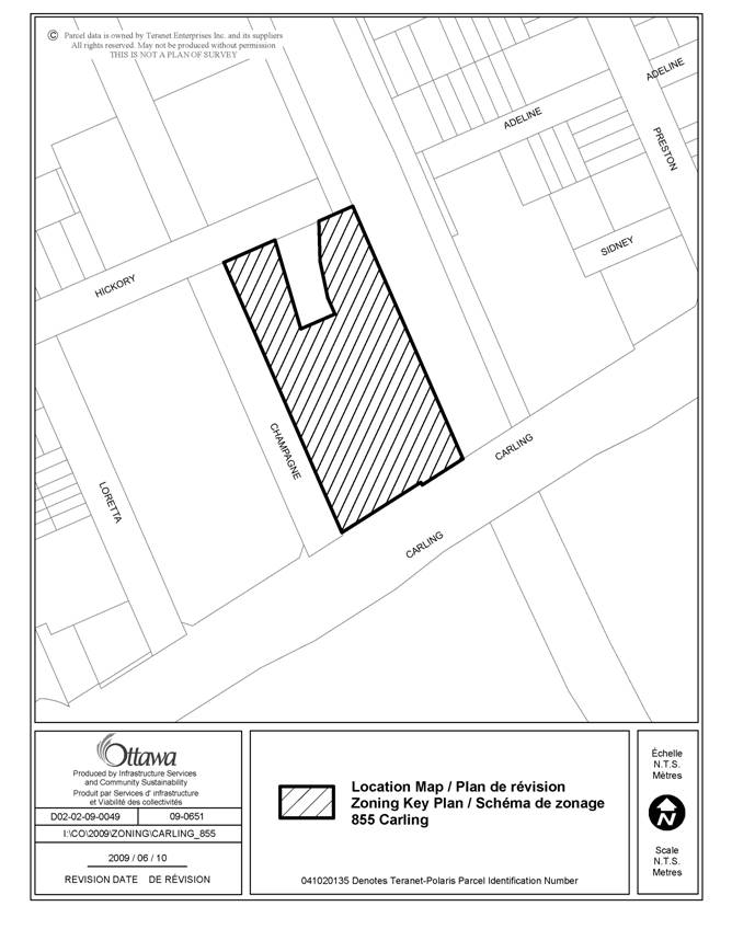
That the Planning and Environment Committee recommend Council approve an amendment to the Zoning By-law 2008-250 to change the zoning of 855 Carling Avenue from MC[24] F(2.5) Schedule 129 and MC F(1.5) to MC[24] F(4.1) Schedule 249, as shown on Document 1 and as detailed in Document 2.
RECOMMANDATION
DU RAPPORT
Que le Comité de recommande au Conseil d’approuver une modification au Règlement de zonage 2008-250 afin de
faire passer le zonage du 855, avenue Carling de MC[24] F(2.5), annexe
129, et MC F(1.5) à MC[24] F(4.1), annexe 249, tel qu’illustré dans le Document
1 et exposé en détail dans le Document 2.
BACKGROUND
The subject site is located at the northeast corner of Carling Avenue and Champagne Avenue. The property is bounded on the south by Carling Avenue which is a designated Arterial Mainstreet, Champagne Avenue to the west, Hickory Street to the north and the O-Train corridor to the east. West of the site is an existing office development consisting of two office towers, nine and seven storeys respectively.
North of the site is a vacant residential property that is the subject to an application for change in zoning. East of the site is the north-south O‑Train line and south of the site on the opposite side of Carling Avenue are federally owned lands which are currently vacant. The property is approximately 0.9 hectares in area. The property has a frontage of approximately 71 metres along Carling Avenue and is approximately 122 metres in depth. This property occupies almost an entire city block except for a small irregular parcel known as 140 Hickory Avenue. The site is currently being utilized as a surface parking lot comprised of 300 spaces servicing Civic Hospital employees.
The property is located within the Preston-Champagne Secondary Plan and is subject to two land use designations under the Secondary Plan. The southern portion of the property is designated as High-Profile, Offices and the northern portion is designated as Medium-Profile, Offices.
Under the Primary Official
Plan, the property is located at the
southern edge of an area designated as a Mixed-Use Centre on Schedule B, Urban
Land Use. The Mixed-Use Centre designation extends from the
subject site to Carling Avenue along the O-Train Corridor, and is currently
subject to the Carling-Bayview Community Design Plan (CDP) process. As a Mixed-Use Centre, the site is identified
as offering potential for advancing and achieving the City's intensification
objectives through compact mixed-use development focused on the City's transit
system. An analysis of the nature and intensity of development for all lands
within the CDP area is intended to be completed through the CDP process.
The section of Carling Avenue abutting the subject property is designated as a Supplementary LRT Transit Intensive Corridor in the City's Transportation Master Plan, to provide a future at-grade LRT connection to the main Rapid Transit Network at Lincoln Fields and Carling Stations within the 2031 planning horizon. Carling Avenue is also subject to the Western LRT Corridor (Bayview to Baseline) Planning and Environmental Assessment Study (ACS2009-ICS-PLA-0050) which is currently underway and may accelerate LRT implementation along Carling Avenue as a Rapid Transit Corridor rather than as a Supplementary LRT Corridor, subject to the requirements of the Transit Project Assessment Process (Ontario Regulation 231/08) under the Ontario Environmental Assessment Act (OEAA) and the Canadian Environmental Assessment Act (CEAA). The intersection of Carling Avenue and the existing north-south O-train line is a significant intersection with respect to the future development of light rail transit and as a result, additional land requirements beyond the protected right-of-way outlined within the Official Plan will require protection.
Purpose of Zoning Amendment
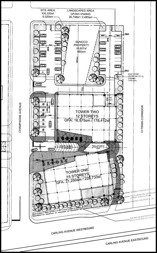
The applicant is proposing to construct two new office towers, which will be connected via a second-storey link as shown on Document 3. Tower "One" will be approximately 56 metres (15 storeys) in height and front along Carling Avenue. Tower “One” would be setback approximately three metres from Carling Avenue and six metres from the O-Train corridor abutting the eastern portion of the site. Tower "Two", which will be located approximately in the middle of the subject property, will have a height of 45 metres (12 storeys) and be setback 19 metres from Carling Avenue and five metres from the O-Train corridor.
Four levels of underground parking are proposed that will create 742 spaces, to be accessed from Champagne Avenue. Also, 58 surface parking stalls are proposed to be provided on the northern and western edge of the property. Vehicular access to the site would be from Champagne Avenue and Hickory Street. There is no proposed access to the site from Carling Avenue.
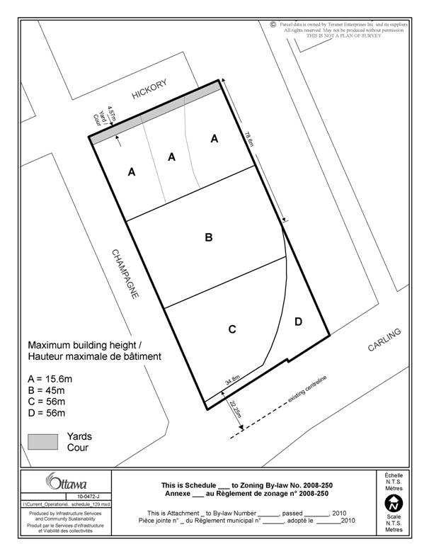
The property currently has two zoning designations. The western portion, and the majority of the property, is zoned "Mixed-Use Centre" MC[24] F(2.5) S129. Exception 24 refers to a maximum building height as per Schedule 129, which varies from a permitted height of 15.6 metres for the northern portion of the site along Hickory Street (Area "A" of Schedule 129), 27.3 metres mid-block (Area "B") and 39 metres for the southern portion of the site along Carling Avenue (Area "C"). Exception 24 also refers to specific yard requirements, which includes a minimum 9.14-metre set back along Carling Avenue, and a 4.7-metre setback along Champagne Avenue and Hickory Street. Exception 24 also requires that 50 per cent of the required parking be located below grade or within a parking structure. The permitted floor space index (FSI) for this portion of the property allows for the gross floor area of a building to be 2.5 times the total lot area.
The eastern strip of the property is zoned "Mixed-Use Centre" MC F(1.5). The permitted FSI for this portion of the property allows for the gross floor area of a building to be 1.5 times the total lot area.
The applicant is requesting an amendment to Schedule 129 to allow for an increase in the permitted height within Area "A" from 39 metres to 56 metres, and an increase in the permitted height within Area "B" from 27.3 metres to 45.0 metres. The current permitted height of 15.6 metres for Area "C" of Schedule 129 would remain. The applicant is requesting a further amendment to Schedule 129 to allow for a reduced front yard setback along Carling Avenue of 9.14 metres to 3.0 metres. The remaining provisions of Exception 24 would continue to apply with respect to parking. The applicant is also requesting an increase in the floor space index (FSI) on the west side of the site from 2.5 to 4.1, and an increase in the FSI on the east side of the property from 1.5 to 4.1 to facilitate the proposed development.
DISCUSSION
Strategic Directions
To meet the challenge of managing growth the City will direct growth to the Urban Area, and specifically to areas designated as Central Area, Mixed-Use Centres, Employment Areas, Enterprise Areas, Developing Communities and Mainstreets. These areas include locations that are centred on the rapid-transit network, major roads, commercial streets, and large tracts of vacant land. The City will encourage a pattern and density of development that supports transit, cycling and walking as viable alternatives to the automobile. Development in these areas can strengthen the urban structure, balance housing and employment uses, and make transit provision more efficient.
These areas offer substantial opportunities for new development or redevelopment and represent a key element in the Official Plan’s strategy to accommodate and direct growth in the city. Mixed-Use Centres will grow substantially, but in a way that complements the development pattern within and adjacent to them.
A key direction for areas where more intense mixed-use development is to be provided, and specifically for Mixed-Use Centres, is that they be developed as centers of activity in a way that is compact and will contribute to place-building through an organization of uses and urban form that provides for a strong pedestrian environment and orientation to transit along with strong interconnections to and through adjacent areas.
Mixed-Use Centre and Arterial Mainstreets
The subject property and adjacent areas are designated Mixed-Use Centre and this section of Carling Avenue is designated Arterial Mainstreet on Schedule B of the Official Plan (OP). Mixed-Use Centres are strategic locations along transit corridors that act as focal points of activity for both the local and regional community. These areas have a high potential for mixed-use, compact development and are to develop as vibrant places in their own right as components of a complete neighbourhood. Development within a Mixed-Use Centre should take advantage of the opportunities offered by transit, and for ease of cycling and pedestrian movements. With a focus placed on urban design and a mix of uses, these areas will contribute to diversity in the area and facilitate the creation of centres of activity. The proposed development concept as shown on Document 3 introduces a density and form of development that is appropriate taking into consideration the policies of Mixed-Use Centres and Arterial Mainstreets.
Along Arterial Mainstreets redevelopment and infill is encouraged to optimize the use of land through increased height (up to eight storeys) and density. Additional increases in height and density along Arterial Mainstreets are to be considered in circumstances where the development is at a gateway location or at a location where there are opportunities to support transit, at a transit stop or station. The site is located just west of the Preston Street (Little Italy) gateway at the intersection of Carling Avenue and Preston Street. As well, the site is at a strategic existing transit location, just west of the existing north-south O-Train line, and along existing bus routes on Carling Avenue. Based on the above criteria to be considered in such requests, the proposed increase in height and increased floor space index (FSI) is consistent with the direction of the OP for Arterial Mainstreets that allows for such considerations. The existing maximum permitted height on the southern portion of the site along Carling Avenue would permit a building approximately 11 storeys in height with a 3.5-metre floor to floor plate, which currently exceeds the OP policy. The proposed building height of 15 storeys for Tower One is considered a minor increase from the current permitted height, and any potential impacts may be further reduced through the Site Plan Control process.
With the placement of the proposed 15-storey office tower a maximum of three metres from Carling Avenue, a strong street edge is created with ample room for improved sidewalks to allow for easy pedestrian movement both within the site and through to access the O-Train station to the east and bus stops along Carling Avenue. The existing sidewalk along Champagne Avenue allows for movements to the north into the existing neighbourhood and is further enhanced with additional landscaping and courtyard elements at grade within the design of Towers One and Two.
As a result, the reduced front yard setback along Carling Avenue from 9.14 metres to 3.0 metres is considered appropriate for the site towards advancing the urban design of this Arterial Mainstreet.
Regarding the mix of uses which typically accompany increased density within Mixed-Use Centre developments, the proposed concept plan does not provide any ground floor retail or commercial space which can inhibit the implementation of the Mixed-Use Centre policies that speak to creating lively places with a range of uses that appeal to the local and wider community. As a result, staff recommends that the implementing By-law as shown on Document 2 require that retail, commercial or personal service type uses be located at-grade along the frontage of Carling Avenue. The proposed performance standard would implement the intent of the Mixed-Use Centre policies to develop such areas as vibrant spaces which are part of complete neighbourhoods.
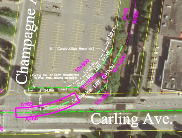
Last, as Mixed-Use Centres are strategically located with respect to the transportation system and are accessible by transit, both the existing and planned function of the area must be protected where possible, while not interfering with as-of-right development situations. As the subject property is designated as a Supplementary LRT Transit Intensive Corridor to provide a future at-grade LRT connection to the main Rapid Transit Network within the 2031 planning horizon, and also subject to the Western LRT Corridor Planning and Environmental Assessment Study currently underway, staff have completed an assessment of the site and determined an appropriate area to be protected from the developable area of the property as shown on Document 4. Staff recommends that a triangular piece of land at the southeast corner of the site preclude any form of development or use other than a public transit use. As well, the recommended by-law would also restrict development within a vertical area extension of this triangular area for a height of approximately 15 metres, effectively creating a three-dimensional box to be used only for transit infrastructure, the details of which are not known at this time. As a result, the development concept would need to be revised accordingly to accommodate the excluded area, which will impact the proposed pedestrian walkway along the eastern portion of the site. However, staff feel that through the detailed design and Site Plan Control process an appropriate design can be brought forward that respects the intent of the Mixed-Use Centre and applicable design guidelines. Due to the strategic location of the site relative to the various land use designations, and the unknown aspects regarding the specific transit technology to be implemented at this site, it is appropriate to secure this portion of the site for future transportation infrastructure needs.
Compatibility and Community Design
Direction is provided in Section 2.5.1 as to the meaning of compatible development. In general terms, it provides for compatible development meaning, development that although not necessarily the same as or similar to existing buildings, nonetheless enhances an established community and coexists with it. The development fits well within its physical context and works well among the functions that surround it. Broad design objectives are set out as to how the City wants to influence the built environment. These objectives are generally stated and are applicable to all land use designations either at the city-wide level or on a site-specific basis. Design principles are further set out to describe how the City hopes to achieve the design objectives, with acknowledgment that all the design objectives may not be achievable in all cases.
The proposed development is consistent with and implements the various aspects of the design objectives and principles discussed below. The objectives of greatest significance to the application speak to enhancing the sense of community, defining quality public and private spaces through development and providing for the creation of adaptable and diverse places.
The first design objective to enhance a sense of community is achieved by infilling a large, underutilized vacant site that does not continue a built form within a designated Mixed-Use Centre which is also along a transit priority route. The development will establish a focus at a key location along Carling Avenue, within the southern limit of the Preston-Champagne Secondary Plan that can contribute to the redevelopment of the immediate area as a significant place under the applicable land use policies.
Encouraging a continuous street frontage and being cognisant of
pedestrian needs that contribute to public spaces, is the second key design
objective. As a result of the decreased
setback along Carling Avenue, a tighter built form is created that is currently
absent due to the use of the site as a surface parking lot. The integration of walkways, landscaping and
open spaces at grade provides some variation that serves to create an amenity
area and space for pedestrian movement through the site and through the
immediate area. With respect to meeting
the needs of pedestrians, the introduction of new commercial or retail uses at
grade, as recommended, will create opportunities for social and commercial
interactions that previously did not exist. The proposed design will take
advantage of the natural focal point along this segment of Carling Avenue and
the significant location along the existing and proposed transit network.
The objective of creating
adaptability and diversity will be implemented through a more diverse building
envelope that efficiently uses land while contributing to the regeneration of
Carling Avenue. The development as proposed will create new employment space
with additional retail and service uses as recommended. The development will also help reduce
resource consumption by intensifying inside the Urban Area along a Transit
Priority Corridor and by providing services to local residents.
Preston-Champagne Secondary Plan
Schedule L of the Preston-Champagne Secondary
Plan identifies the site as being located in the southwest quadrant of
the Plan area. The property has two
employment designations as per Schedule L with the southern portion of the
property designated as High-Profile, Offices and the northern portion
identified as Medium-Profile, Offices.
The Preston-Champagne
Secondary Plan does not contain specific height limitations but rather outlines
various profiles for the land use schedule.
The planned function for this area speaks to a mix of medium-profile
and high-profile employment uses focusing on both sides of Carling Avenue
including existing buildings. The
northwest edge of the area will be redeveloped with low-profile residential
uses to provide a transition to the existing lower-profile residential areas to
the north and west. As well, the
policies of the Preston-Champagne
Secondary Plan speak specifically to the area around Carling and Champagne
Avenue to become a Secondary Employment Centre, and should consider development
proposals which provide for a mix of uses, with residential uses integrated
within to allow for a decreasing transition in development moving north from
Carling, with landscaped spaces and pedestrian links between spaces and to transit.
For predominately office-oriented developments, surface parking shall be
permitted within the first phase only and limited, with subsequent phases to
provided structured or underground parking. As the concept plan proposes building heights
decreasing from 15 storeys on the southern edge to 12 storeys mid-block,
serviced with four levels of underground parking and limited surface parking, the
proposal is consistent with the intent of the Preston-Champagne Secondary
Plan. Where the project is not
consistent with the Secondary Plan relative to providing a mix of ancillary
retail and services uses, and as a result the recommendation requires appropriate
non-residential uses to be located on the ground floor along the Carling Avenue
frontage in order to create a more active street environment.
RURAL IMPLICATIONS
N/A
CONSULTATION
Notice of this application was carried out in
accordance with the City's Public Notification and Consultation Policy.
COMMENTS BY THE WARD COUNCILLOR(S)
The Ward Councillor is aware of this application and the staff recommendation.
LEGAL/RISK MANAGEMENT IMPLICATIONS
The zoning for this site has been appealed to the Ontario Municipal Board as a decision has not been made within 120 days of the application having been deemed complete. A seven-day hearing is scheduled commencing 7 September 2010. Should the staff recommendation be adopted, then the hearing can be conducted within staff resources.
Should the recommendation be refused, it will be necessary for the City Clerk and Solicitor Department to seek to retain an outside plan. It is anticipated that the expenditure required to retain an outside planner for the hearing will be in the order of $35,000 to $45,000.
In order to achieve Council objectives, Committee and Council may wish to consider amending the applicable zoning in any event to provide for the retail, commercial or personal service type uses at grade and the setback from the rail line.
CITY STRATEGIC PLAN
The application is consistent with the Planning and Growth Management priority which encourages the development of employment lands to promote job creation and minimize infrastructure costs.
TECHNICAL IMPLICATIONS
N/A
FINANCIAL IMPLICATIONS
There are no direct financial
implications associated with this report.
APPLICATION PROCESS TIMELINE STATUS
The application was not processed by the "On Time Decision Date" established for the processing of Zoning By-law amendments due to additional time required for the assessment and analysis of the potential conflicts with the development of the site and the advancement of future transit services.
SUPPORTING DOCUMENTATION
Document 1 Location Map
Document 2 Details of Recommended Zoning
Document 3 Concept Plan
Document 4 Protected Transit Corridor
Document 5 Consultation Details
DISPOSITION
City Clerk and Solicitor Department, Legislative Services to notify the owner, applicant, OttawaScene.com, 174 Colonnade Road, Unit #33, Ottawa, ON K2E 7J5, Ghislain Lamarche, Program Manager, Assessment, Financial Services Branch (Mail Code: 26-76) of City Council’s decision.
Planning and Growth Management to prepare the implementing by-law, forward to Legal Services and undertake the statutory notification.
Legal Services to forward the implementing by-law to City Council.
LOCATION MAP DOCUMENT
1
DETAILS OF RECOMMENDED ZONING DOCUMENT 2
Proposed Changes to By-law 2008-250
1. Replace Schedule 129 with a new schedule as shown on Document 3.
2. In Exception 24 of Section 239, Urban Exceptions:
(a) delete the zone code in column II and replace it with MC[24] F(4.1) Sxxx
(b) delete the provisions in column V and replace them with the following:
- maximum building height, and required Hickory Street yard setback in accordance with Schedule 129
- at least 50% of required parking spaces to be located below grade or in a structure
- only the following uses are permitted on the ground floor of that portion of a building along Carling Avenue for a depth of 21 metres from Carling Avenue:
artist studio
bank
bank machine
bar
cinema
community centre
community health and resource centre
convenience store
day care
instructional facility
library
medical facility
museum
nightclub
personal service business
Post office
recreational or athletic facility
restaurant
retail food store
service and repair shop
theatre
- lobby area can only occupy a maximum of 25% of the ground floor of that portion of a building along Carling Avenue for a depth of 21 metres from Carling Avenue
- minimum yard setback from the south lot line abutting Carling Avenue: 3.0 m
- minimum yard setback from east lot line abutting the transit corridor of the O-Train: 4.57 m
- minimum yard setback from west lot line abutting Champagne Street: 4.57 m
- In Area D on Schedule 129 the only permitted use in the three dimensional area measured from grade to a height of 15.0 metres is a rapid transit network
3. Rezone the land from MC[24] F(2.5) and MC F(1.5) to MC[24] F(4.1) Sxxx as shown on Document 1.
Revised Schedule 129
CONCEPT PLAN
DOCUMENT 3
PROTECTED TRANSIT CORRIDOR DOCUMENT 4
CONSULTATION DETAILS DOCUMENT
5
NOTIFICATION AND CONSULTATION PROCESS
Notification and public consultation was undertaken in accordance with the Public Notification and Public Consultation Policy approved by City Council for Zoning By-law amendments.
SUMMARY OF PUBLIC INPUT
Five letters were received from
the public and the local community association as a result of the
circulation. A summary of the comments
and concerns raised and a response are summarized below.
1. Concerns were raised with respect to a potential increase in traffic in the area.
Response:
The applicant has prepared a traffic impact assessment in support of their application which has been reviewed and approved by staff. Through the Site Plan Control process a detailed analysis of the traffic impacts and site design will be undertaken.
2. A request was made that the subject application be postponed to allow for the completion of the Carling-Bayview Community Design Plan.
Response:
The policies within the Official Plan allow for development outside of a completed Community Design Plan, and such an application will be reviewed against the applicable policies of the Official Plan. Staff are satisfied that the proposal implements the intent of the Mixed-Use Centre policies with a pedestrian friendly, transit supportive and compact development, while having due regard for the policies with respect to compatibility and urban design.
3. Concerns were raised with respect to the potential increase in shade and loss of sunlight on abutting residential areas to the north
Response:
Through the Site
Plan Control process the applicant will be required to submit a sun-shadow
analysis of the proposed development to better evaluate and consider such
potential impacts.
COMMUNITY ORGANIZATION COMMENTS
Dalhousie Community Association
The Dalhousie Community Association requests that the City postpone considering the current application until such time as the Carling-Bayview Community Development Plan is completed. The Dalhousie Community Association is also concerned with how the proposed building may restrict a future LRT access Carling Avenue and request the application not be considered until the appropriate studies are complete.