Report to/Rapport au :
Planning and Environment Committee
Comité de l'urbanisme et de l'environnement
and Council / et au Conseil
25 August 2010 / le 25 août 2010
Submitted by/Soumis par : Nancy Schepers, Deputy City Manager
Directrice municipale adjointe, Infrastructure Services and Community Sustainability, Services d'infrastructure et Viabilité des collectivités
Contact Person/Personne-ressource : Richard Kilstrom, Acting Manager/Gestionnaire intérimaire, Development Review-Urban Services, Inner Core/Examen des projets d'aménagement-Services urbains, Unité du Centre intérieur
Planning and Growth Management/Urbanisme et Gestion de la croissance
(613) 580-2424, 22379 Richard.Kilstrom@ottawa.ca
|
SUBJECT: |
zoning - 90 Richmond ROad, 114 Richmond Road and 380 leighton terrace (FILE NO.d02-02-10-0021) |
|
|
|
|
OBJET : |
ZONAGE – LE 90 ET LE 114 DU CHEMIN RICHMOND AINSI QUE LE 380 DE LA TERRASSE LEIGHTON |
REPORT RECOMMENDATIONS
That the recommend Council approve an amendment to Zoning By-law No. 2008-250 to change the zoning of 90 Richmond Road, 114 Richmond Road and 380 Leighton Terrace from Minor Institutional (I1A), Traditional Mainstreet (TM[83] H(15)) and Residential First Density (R1MM[762]), to a Traditional Mainstreet Exception zone with a Schedule and holding symbol (TM[1763] S256-h) and a Residential Fifth Density Subzone B Exception zone with a Schedule and holding symbol (R5B[1763] S256-h), to permit a Mixed Use and Residential Development, as shown in Document 1 and Detailed in Documents 2 and 3.
RECOMMANDATIONS DU RAPPORT
Que le Comité de l’urbanisme et de l’environnement recommande au Conseil d’approuver la modification du Règlement de zonage no 2008-250 visant à faire passer la désignation de zonage des propriétés situées au 90 et au 114 du chemin Richmond ainsi qu’au 380 de la terrasse Leighton de zone de petites institutions (I1A), de zone de rue principale traditionnelle (TM[83] H(15)) et de zone résidentielle de densité 1 (R1MM[762]) à une zone de rue principale traditionnelle, assortie de l’exception 1763, de l’annexe 256 et du symbole d’aménagement différé (TM[1763] S256-h), et à une sous-zone résidentielle de densité 5 B, assortie d’une exception, de l’annexe 256 et du symbole d’aménagement différé (R5B[xxxx] S256-h), en vue de permettre un aménagement résidentiel et polyvalent, tel qu’il est illustré dans le document 1 et expliqué en détail dans les documents 2 et 3.
EXECUTIVE SUMMARY
Assumptions and Analysis:
The subject lands are located on the south side of Richmond Road, west of Island Park Drive, on the eastern edge of Westboro Village. The subject lands consist of three separate but contiguous properties, 90 Richmond Road, 114 Richmond Road and 380 Leighton Terrace. The entire subject lands are designated Traditional Mainstreet and General Urban Area in the Official Plan.
Development Proposal
The development proposal for the subject lands can be viewed as being divided into three separate components. The first is a mixed-use development on the northern part of the property; the second is a residential development on the southern portion of the site while the third is proposed extensive areas of public space, including a pedestrian walkway along the eastern portion of the site to connect Richmond Road and the Byron Avenue Linear Park.
Traditional Mainstreet Component
The proposed development satisfies Traditional Mainstreet policies as it will bring a new building to Richmond Road and create an animated pedestrian-friendly environment along this street edge. The proposed height increase is considered appropriate as the property is a node and is compatible with other medium profile buildings in the area. The design of the building will be approved through the Site Plan Control process and will complement the character of the Richmond Road Traditional Mainstreet.
The adaptive reuse of the existing heritage buildings, the construction of a second mixed-use building to the south of the monastery, as well as the use of the open space component to provide public space and patios, will also strengthen the Traditional Mainstreet character of this portion of the site.
General Urban Area Component
It is the Department’s position that the residential portion of the proposal satisfies policies for developments in General Urban Areas. The proposal provides the opportunity for a variety of housing options. The residential units facing Leighton Terrace and along Byron Avenue are intended to have ground floor access to create a character similar to that currently found in the neighbourhood.
Open Space
There will be a landscaped public right-of-way running down the eastern edge of the property, from the Byron Linear Park to Richmond Road; it will include a mature stand of existing maple trees. Only the existing heritage buildings and accessory uses will be permitted in this landscaped area.
Official Plan Amendment Number 76
The proposed development satisfies compatibility policies in Official Plan Amendment 76 related to integrating intensification projects into the surrounding community. The proposed development uses means such as setbacks, building transitions and architectural design to satisfy these policies and to ensure that the development will relate positively to the community.
Richmond Road/Westboro Secondary Plan
The site is subject to the policies of the Richmond Road/Westboro Secondary Plan. The proposed development satisfies the relevant policies of the Community Design Plan and Secondary Plan related to intensification by addressing issues which pertain to transition in building height, setbacks and minimizing the impact of shadowing.
Exceptions to the Zoning
To ensure the compatibility of the development with the community, the Department is recommending exceptions to the parent Traditional Mainstreet and Residential Zoning. These exceptions are: a specific height and setback schedule, restriction of uses, reducing parking requirements and the location of vehicular access.
In addition to regulating certain uses and performance standards, the Department is also recommending that a holding zone apply to the property. The holding zone, which will prohibit development from proceeding, will only be removed to allow development when a Site Plan Control Agreement is approved and registered on title. The intent of the holding zone is to use the Site Plan Control process to control the design of the building.
Legal/Risk Management Implications:
If the staff recommendation is adopted and the resulting by-law is appealed to the Ontario Municipal Board, it is anticipated that a one-week hearing would result. Staff from the Planning and Growth Management Department would be able to provide evidence on behalf of the City.
If the zoning amendment request is refused, reasons will have to be provided. Should the refusal be appealed to the Ontario Municipal Board, it is expected that a two-week hearing would result. Depending on the reasons identified, up to three outside witnesses would need to be retained (Planning, Transportation, Infrastructure). The estimated cost for the retention of such witnesses is in the range of $45,000 to $110,000.
Technical Implications:
N/A
Financial Implications:
N/A
Public Consultation/Input:
Five meetings were held with the public and the Ward Councillor. Notice of this application was carried out in accordance with the City's Public Notification and Consultation Policy. The City received 67 comments from the public and three comments from Community Associations, all expressing concerns over the proposal. The issues can be summarized as follows: Buildings are too high, too much density, too much traffic, not in conformity with the Official Plan or the Richmond Road/Westboro Secondary Plan, not in conformity with the character of the existing neighbourhood, not enough infrastructure capacity to accommodate the proposal.
As part of the consultation process, the City also engaged a Peer Design Review Panel to comment on and critique the applicant’s proposal. The panel consisted of a landscape architect, an architect and a heritage conservation expert. The Peer Design Review Panel will also be engaged as part of the Site plan Control Process to provided advice and guidance on the design of the proposed buildings and public space. A copy of their comments and design sketches, resulting from their analysis, are presented in Documents 5 and 6.
RÉSUMÉ
Hypothèses et analyse :
Les biens-fonds susmentionnés sont situés du côté sud du chemin Richmond, à l’ouest de la promenade Island Park et en bordure est du village de Westboro. Il s’agit de trois parcelles distinctes mais contiguës : le 90 et le 114 du chemin Richmond de même que le 380 de la terrasse Leighton. L’ensemble des terrains concernés se trouve dans une zone désignée rue principale traditionnelle et secteur urbain général dans le Plan officiel.
Projet d’aménagement
Le projet d’aménagement des trois parcelles visées comporte trois volets, le premier étant un aménagement à utilisations mixtes dans la portion nord du bien-fonds; le deuxième, un aménagement résidentiel dans la portion sud de la propriété et le troisième, les vastes espaces publics envisagés, y compris une voie piétonnière longeant le côté est de la propriété et liant le chemin Richmond au parc linéaire de l’avenue Byron.
Composante « rue principale traditionnelle »
Le projet d’aménagement envisagé est conforme aux politiques sur les rues principales traditionnelles puisqu’il ajoutera un nouveau bâtiment sur le chemin Richmond et créera un milieu animé et accueillant pour les piétons le long de cette rue. Bien que la hauteur du bâtiment proposé dépasse les limites permises actuellement, elle est jugée adéquate puisqu’elle est compatible avec les autres bâtiments de taille moyenne dans le secteur et que la propriété est considérée comme un noyau d’activité. Le design du bâtiment sera approuvé dans le cadre du processus de réglementation du plan d’implantation et s’harmonisera au caractère de rue principale traditionnelle du chemin Richmond.
La réutilisation adaptée des édifices patrimoniaux existants, la construction d’un deuxième bâtiment à utilisations mixtes au sud du monastère, de même que la composante des espaces libres, qui comprendra des espaces publics et des terrasses, renforceront aussi le caractère de rue principale traditionnelle de cette portion des lieux.
Composante « secteur urbain général »
Le Service est d’avis que la portion résidentielle du projet est conforme aux politiques relatives à l’aménagement des secteurs urbains généraux. Le projet offre diverses possibilités en matière de logement. Les habitations donnant sur la terrasse Leighton et celles qui longent l’avenue Byron auront un accès au rez-de-chaussée, ce qui créera un caractère semblable à celui qu’on trouve dans le voisinage.
Espaces libres
Un couloir paysagé allant du parc linéaire Byron au chemin Richmond longera le côté est du terrain; il englobera le peuplement existant d’érables matures. Seules les utilisations permises actuellement pour les édifices patrimoniaux et les bâtiments accessoires seront autorisées dans l’aire paysagée.
Modification no 76 au Plan officiel
Le projet d’aménagement est conforme aux politiques relatives à la compatibilité établies par la modification no 76 au Plan officiel en ce qui concerne l’intégration des projets de densification dans le secteur environnant. Le recours à des moyens comme les retraits et les éléments de transition et de design architectural fait en sorte qu’il respecte ces politiques et cadre harmonieusement avec le voisinage.
Plan secondaire du secteur du chemin Richmond à Westboro
Le terrain visé est assujetti aux politiques du Plan secondaire du secteur du chemin Richmond à Westboro. Le projet d’aménagement est conforme aux politiques pertinentes du Plan de conception communautaire et du Plan secondaire qui se rapportent à la densification, puisqu’il comporte des retraits ainsi que des mesures pour assurer une transition à l’égard de la hauteur des bâtiments et réduire autant que possible les effets de l’ombre.
Exceptions
Pour s’assurer que l’aménagement est compatible avec le secteur environnant, le Service recommande d’admettre des exceptions à la désignation de zone résidentielle et de rue principale traditionnelle établie. Les exceptions proposées sont : une annexe présentant la hauteur et les retraits autorisés, la restriction des utilisations permises, une réduction des exigences en matière de stationnement et l’emplacement de l’accès des véhicules.
Outre la réglementation de certaines utilisations et normes de rendement, le Service recommande également que les biens-fonds soient désignés zone d’aménagement différé. Une telle désignation, qui interdira jusqu’à nouvel ordre l’aménagement des parcelles, sera supprimée seulement une fois que l’accord de réglementation du plan d’implantation aura été approuvé et qu’un avis en ce sens aura été enregistré au titre. Le but de cette mesure est de pouvoir compter sur le processus de réglementation du plan d’implantation pour contrôler le design du bâtiment.
Incidences juridiques / concernant la gestion des risques :
Si la recommandation du personnel est adoptée et qu’il est interjeté appel du règlement qui en découlera auprès de la Commission des affaires municipales de l’Ontario, on prévoit qu’une semaine d’audience s’ensuivra. Le personnel du Service de l’urbanisme et de la gestion de la croissance pourrait fournir des preuves au nom de la Ville.
Si la demande de modification du zonage est refusée, il faudra en fournir les raisons. S’il est interjeté appel du refus auprès de la Commission des affaires municipales de l’Ontario, on s’attend à deux semaines d’audience. Selon les raisons évoquées, jusqu’à trois témoins extérieurs pourraient être retenus (Urbanisme, Transports et Infrastructure). On estime que les coûts engendrés pour retenir de tels témoins s’échelonnent entre 45 000 $ et 110 000 $.
Incidences techniques :
S.O
Répercussions financières :
S.O.
Consultation publique/commentaires :
Il y a eu cinq réunions auxquelles ont participé les résidents et la conseillère du quartier visé. Avis a été donné de la demande d’aménagement, conformément à la politique municipale sur les avis publics et la consultation. La Ville a reçu 67 commentaires de la population et trois, d’associations communautaires et tous ont exprimés des préoccupations à l’égard du projet, celles-ci pouvant être résumées comme suit : les bâtiments sont trop élevés, la densification est trop importante, le projet entraînera une trop grande augmentation du volume de la circulation, le projet n’est pas conforme aux dispositions du Plan officiel ou du Plan secondaire du secteur du chemin Richmond à Westboro, le projet ne respecte pas le caractère du voisinage, la capacité de l’infrastructure n’est pas suffisante pour soutenir le projet.
Dans le cadre du processus de consultation, la Ville a également fait appel à un comité d’examen du design par les pairs pour qu’il examine le projet envisagé et en fasse la critique. Le comité était formé d’un architecte paysager, d’un architecte et d’un spécialiste en conservation du patrimoine. Le Comité a également été engagé dans le cadre du processus de réglemenation du plan d’implantation afin de donner son avis et des directives quant au design des édifices proposés et de l’espace public. Une copie de leurs commentaires et des esquisses découlant de leur analyse sont présentées dans les documents 5 et 6.
BACKGROUND
The subject lands are located on the south side of Richmond Road, west of Island Park Drive, in an area described as the East Village, which is located on the eastern edge of an area generally known as Westboro Village. The subject lands consist of three separate but contiguous properties, 90 Richmond Road, 114 Richmond Road and 380 Leighton Terrace. Immediately to the west of the subject lands is Hilson Avenue Elementary School and single detached dwellings on Shannon Street. To the east are typical conventional two-storey single-detached dwellings along Leighton Terrace, while further to the west, along Richmond Road, are various types of commercial uses typically found along Traditional Mainstreets. To the south is the Byron Avenue Linear Park and across Byron Avenue is low profile residential housing. To the north of the subject property are two newly-approved mixed/use developments with commercial uses on the ground floor and residential uses above. One building will be six storeys (101 Richmond Road) while the other (111 Richmond Road) will be eight storeys. As with the southern side of Richmond Road, the northern side also contains commercial uses typically found on Traditional Mainstreets.
The largest of the three subject properties is 114 Richmond Road. This property is rectangular in shape and has frontage along Richmond Road and the Byron Avenue Linear Park of approximately 96 metres. The depth of this property is approximately 217 metres, giving it an area of approximately 2.1 hectares. Along the south-western edge of the site the property abuts the Shannon Street Road allowance for a depth of approximately 15 metres. Located on this site is the former Sisters of the Visitation Monastery, which includes an associated chapel and a residence. The residence on the property was constructed in 1865, in the style of Gothic Revival and is known as “The Elms.” It was the home for a succession of families until 1910, when it was purchased by the Roman Catholic Church (The Sisters of the Visitation) and became a monastery. In 1913, a large addition was constructed to the existing house, greatly enlarging the monastery. The portion of 114 Richmond Road in front and to the rear of the buildings on the property is landscaped space, with large hardwood trees located to the north of the building and down the entire eastern side of the property. A large willow tree is located near the south‑western corner of the property. The property at 114 Richmond Road is currently zoned Minor Institutional (I1A), in light of its use as a monastery.
On April 14, 2010, City Council voted to designate the Sisters of the Visitation under Part IV of The Ontario Heritage Act for its cultural heritage value. Designation under The Ontario Heritage Act identifies the heritage attributes of historic places and requires that these attributes be protected. The “Statement of Cultural Heritage Value” for this property as approved by City Council is included as Document 7. As a result of its designation under Part IV of The Ontario Heritage Act, any changes to the property that affect its heritage attributes will require an application under The Ontario Heritage Act and will not proceed without City Council support. The designation of the property was appealed by the owner, but according to the Act, it is protected from the issuance of the “Notice of Intent to Designate.”
The property at the southeast corner of Leighton Terrace and Richmond Road (90 Richmond Road) was, until recently demolished, occupied by a single-storey building formerly used for retail sales. This property is square in shape and has 22 metres of frontage along Richmond Road, 31 metres of frontage along Leighton Terrace and has an area of approximately 0.06 hectares. This property is currently zoned as Traditional Mainstreet (TM[83] H(15)).
The third property proposed for redevelopment is 380 Leighton Terrace. This property is adjacent to the commercial property at 90 Richmond Road and is currently occupied by a one‑storey single-detached dwelling. This property has frontage along Leighton Terrace of approximately 15 metres and a depth of approximately 20 metres, for a lot area of approximately 0.04 hectares. This property is currently zoned Residential R1MM[762].
The subject lands are located within the General Urban Area designation in the Official Plan and are designated Traditional Mainstreet. The exact delineation of these two designations is determined by policy 3.6.3.2., which states that the boundary of Traditional Mainstreets is flexible depending on site circumstance and lot configuration. Although it generally applies to those properties fronting onto the road so designated, it may also include properties abutting side streets. The policy goes on to state that "on lots where development has the potential to develop both adjacent to the street and to the rear of the property, the Mainstreet designation will apply to the entire lot.”
Given the flexibility of the Traditional Mainstreet designation and the nature of this proposed development, it is the Department’s position that the Traditional Mainstreet designation and associated Traditional Mainstreet Zoning, should be focused on the lands proposed to be occupied by a mixed-use building along Richmond Road, the heritage building, which through its adaptive reuse most likely will be occupied by public or commercial uses and the mixed-use building proposed to be immediately south of the heritage building. The remainder of the site, which is to contain only residential uses, is considered to fall into the General Urban Area designation and is proposed to be zoned residential (R5B).
Development Proposal
The development proposal for the subject lands can be viewed as being divided into three separate components. The first is the mixed-use development on the northern part of the property, the second is the residential development on the southern portion of the site while the third is the proposed extensive areas of public space, including a pedestrian walkway along the eastern portion of the site to connect Richmond Road and the Byron Avenue Linear Park and the garden in the interior of the existing heritage buildings on the property.
Traditional Mainstreet Component
In the broader context, the subject site is part of a stretch of approximately four blocks in which a larger lot fabric, and a built form pattern with weak building frontage along the sidewalk, introduce a gap between the Richmond Road and West Wellington Traditional Mainstreets. On the north side of the subject site, the two new buildings (101 and 111 Richmond) will feature ground-level retail uses. The subject site on the south side offers that opportunity as well. In combination, the approved buildings and the proposal for the subject site can play a key role in starting to close the gap between the Richmond Road and West Wellington Traditional Mainstreets by introducing continuous activity along the sidewalk.
As part of the Traditional Mainstreet along the entire frontage of Richmond Road (approximately 111 metres), the applicant is proposing to construct a mixed-use building having a height of approximately 30 metres (nine storeys). The applicant is proposing to have approximately 6000 square metres of commercial area on the ground floor and second floor and approximately 210 dwelling units on the upper floors. Through this new building are proposed to be two passageways. One is proposed to have a minimum width of nine metres while the other is proposed to have a minimum width of six metres. Both are proposed to have a minimum height of eight metres. The wider passage is to offer access for vehicles and pedestrians, while the narrower one will be used only by pedestrians. These passageways will provide an entrance to the interior of the site and to the heritage buildings, which have been blocked from public view and access for approximately the last 100 years. These accesses are intended to engage the curiosity of people and provide an invitation of discovery to the heritage buildings on the property. The access corridors will also provide a link to the open areas in the interior of the property, which will contain a large and fully landscaped pathway leading to the Byron Linear Park, as well as patios, gardens and landscaped open space. The mixed-use building is proposed to be separated from the existing heritage buildings to the south by a minimum setback of six metres.
The existing buildings will be designated under Part IV of the Ontario Heritage Act and while it is proposed that the lands containing these buildings be zoned Traditional Mainstreet, their alteration for any use found in the proposed zoning will be subject to approval by City Council. The monastery has a gross floor area of approximately 2325 square metres and a height of approximately 15 metres (four to five storeys). While it is presently uncertain what specific uses will be located in the heritage buildings, preliminary investigations are being undertaken to determine a future use. Among the options being considered is a centre that would rent space to arts groups, or a centre with offices, desks, common spaces and shared facilities that profit and not-for-profit groups working for social innovation would rent. This model has been very successful at the Centre for Social Innovation in Toronto, where over 40 groups share space and ideas. Its mission is “to spark and support new ideas that are tackling the social, environmental, economic and cultural challenges we face today.” Groups include arts and environmental organizations, small communications companies, publishers, law offices, etc.
Immediately behind the monastery is the last building in the Traditional Mainstreet Designation and zoning. The height of this building is intended to be staggered, ranging from 15 to 30.3 metres (four to nine storeys) and contain a mix of residential and commercial uses. The lower heights will be located on the easterly side of the building, with the height increasing towards the westerly portion of the site. It is also expected that there will be some stepping down in height towards the monastery. The commercial component is to be located on the ground floor and will be approximately 930 square metres. The remainder of the building is intended to contain approximately 150 residential apartment units.
Residential Component
The buildings to the south of the Traditional Mainstreet Designation and Zoning are intended to be residential in nature. The easterly building is proposed to be four storeys, (15 metres) and contain approximately 52 dwelling units. The proposed “L” shaped building along the southerly and westerly side of the property is intended to be four storeys along Shannon Street and Byron Avenue, with a portion to the north, stepping up to nine storeys (15 to 30.3 metres). It is proposed to contain approximately 183 units. The use of the buildings in the residential area is intended to be retirement homes of various formats, from independent living condominiums to facilities with a greater amount of care services and amenities. Access to the residential component is proposed to be provided through the Byron Avenue Linear Park.
Open Space Component
In addition to areas where development and the adaptive reuse of heritage buildings will occur, there is a large area of open space. The amount of open space is approximately 8760 square metres, which is approximately 40% of the area of the subject lands. This open space component includes a proposed extensively landscaped walkway between Richmond Road and the Byron Street Linear Park, the preservation of a linear stand of large mature maple trees along the easterly side of the property, the gardens within the interior of the heritage buildings and other landscaped area around the heritage buildings. Through the Site Plan Control Process the use of these and other public spaces will be formalized, but as part of the zoning, their overall location will be identified and the development in this area will be restricted.
DISCUSSION
The Department supports the application to allow development on the site as proposed for the following reasons.
Official Plan Policies
Traditional Mainstreet Component
Lands with a Traditional Mainstreet Designation offer some of the most significant opportunities in the city for intensification through more compact forms of development, a lively mix of uses and a pedestrian-friendly environment. The Official Plan encourages intensification along Mainstreets primarily through the redevelopment of sites and additions to buildings. The most common feature of all Mainstreets is their function as a mixed-use corridor with their ability to provide a wide range of goods and services for both the neighbouring communities and the region at large. Through compact mixed-use and pedestrian-oriented streets, development along Mainstreets is intended to increase support to the public transit system and alternative forms of transportation, to enhance a community focus, and to minimize travel and disruption to existing neighbourhoods.
The applicant's proposed development of the lands Designated Traditional Mainstreet satisfies this direction as it will bring a new building to Richmond Road and create an animated pedestrian friendly environment along this street edge by having retail uses at grade. The design of the building will be approved through the Site Plan Control process and will complement the character of Traditional Mainstreets found in Ottawa by using such methods as different building materials, creation of strong cornice lines, varying setbacks and transition in building heights.
The adaptive reuse of the existing heritage buildings, the construction of a second mixed-use building to the south of the monastery, as well as the use of the open space component to provide public space and patios, will also strengthen the Traditional Mainstreet character of this portion of the site.
Redevelopment and infill are encouraged on Traditional Mainstreets in order to optimize the use of land through increased building height and density. The Official Plan supports building heights in a range of four to six storeys along Traditional Mainstreets, however, the policy framework of the Official Plan also allows greater heights if a proposal meets any one of five certain criteria. These are:
1. Where larger building heights are established in the Zoning by-law based on a Community Design Plan or other Council-approved study.
2. Where proposed heights conform to prevailing building heights or provides a transition between existing buildings.
3. Where a development fosters the creation of a community focus where the proposal is on a corner lot or a gateway location or at a location where there are opportunities to support transit at a transit stop or station.
4. Pursuant to Section 37. of the Planning Act, where a development incorporates facilities, services that in the opinion of the City advances the vision of Mainstreets.
5. Where the application of the provisions of the compatibility policies of the Official Plan determine that additional height is appropriate.
In considering the applicant's request for an increase in height for the mixed-use building along Richmond Road, the Department notes that while only having to satisfy one of any five criteria, it is the Department's contention that the proposal satisfies criteria two, three and five. The proposed 30.3 metre high building along the Richmond Road property frontage offers an excellent transition in height between the 19 metre height limit and 24 metre height limit of the new buildings being constructed on the north side of Richmond Road, opposite the subject site. This variation in building height helps create a jagged height profile, which in turn guards against a "canyon" being created along the street by buildings with identical heights. The use of design techniques mentioned in this submission, such as different building materials, cornices, setbacks and undulations in building width, will also help break up the massing of the building.
Both the mixed-use building along Richmond Road and the proposed higher mixed-use building to the south of the monastery provide a transition in building heights down toward the single detached dwellings on Leighton Terrace, to help lessen the impact on these buildings. Since the building along Richmond Road is proposed to be closer (5.2 metres), it transitions to two storeys, which is the height of buildings along Leighton Terrace. The building behind the monastery transitions down to four storeys, as there is a 20-metre separation distance from this building to the property line along Leighton Terrace.
The subject property is located along Richmond Road, near Island Park Drive, at the eastern edge of the Westboro Commercial Area, which extends west to Golden Avenue. Island Park Drive is the dividing line between the Westboro Commercial Area and the West Wellington Commercial Area, to the east. The size of the subject lands and its location in relation to Island Park Drive, allows it to form part of a node at the eastern gateway to the Westboro Commercial Area, similar to the way the development of the Exchange (nine storeys - 35 metres high) and Westboro Station (ten and eight storeys - 31 and 28 metres high) mixed-use developments recently constructed at the western edge of Westboro village represent a node at that location. The predominance of this site, as part of a gateway node, will help define the entrance and boundary to the neighbourhood along Richmond Road, from the lands to the east. Given these characteristics and in consideration of similar and even greater heights at the western node, the proposed height increases on this property are considered appropriate.
It is also the Department's position that the construction of the two proposed mixed-use buildings, as well as the adaptive reuse of the monastery and the provision of a pedestrian/bicycle pathway between Byron Avenue and Richmond Road, will support an increase in transit usage along Richmond Road and therefore an increased level of service, as intended by the policies of this plan.
The third point relates to compatibility policies found in Section 2.5.1 and 4.11. However, these policies are used to not only evaluate a requested increase in height but also the appropriateness of a development proposal in general. As these policies are also applicable to the portion of the site to be zoned Residential, they will be discussed later in this submission in relation to the entire development.
General Urban Area Component
Approximately the most southerly 81 metres of the subject property is proposed to be zoned as Residential is considered to be subject to the policies of the Official Plan for General Urban Areas. The General Urban Area Designation permits residential development of a full range of housing types to meet the needs of all ages, incomes and life circumstances. Within the General Urban Area, residential intensification is to be evaluated with respect to a set of criteria. One of these is to recognize the importance of development in relation to the existing community character, so that it enhances and builds on desirable patterns and built form. The City must also consider the proposal’s contribution to the achievement of a balance of housing types for a variety of demographics, and that it satisfy the compatibility policies contained in Sections 2.5.1. and 4.11. Finally, consideration should be given to ground oriented forms of housing in established residential areas.
It is the Department’s position that this portion of the proposal satisfies these policies. The proposal will provide the opportunity for a variety of housing options for people of all ages, including seniors and retirement living. The residential units facing Leighton Terrace and along Byron Avenue are intended to have ground floor access, to create a character similar to that currently found in the neighbourhood and builds on the existing built form. As well, through the Site Plan Control process, the Department will ensure that the façade of these buildings will be constructed with materials that fit within the existing community and integrate in terms of character. The proposed building along the Byron Avenue, Leighton Avenue frontages, as well as opposite Shannon Street, will be four storeys. This is typical of the building heights of the existing buildings on the property (monastery) and are not dissimilar to the building heights allowed by the zoning on properties in the surrounding community (three storeys). The higher portion of the “L” shaped building on this portion of the property is to be constructed opposite the parking lot on the adjacent institutional property (Hilson Avenue School) and well away (approximately 60 metres) from the existing residential buildings, to diminish its impact on those residential structures. The monastery on the property is currently constructed in the fashion of an apartment dwelling and the buildings proposed for the property will mimic this characteristic.
The proposed development satisfies the policies contained in Sections 2.5.1. Through the Site Plan Control Process the design of the proposed development will be evaluated so as to have a design that is appropriate for the neighbourhood and that reflects the character of the community, as presented in this submission.
Compatibility Policies
As mentioned, the proposed development for the entire site is subject to consideration of the compatibility policies of the Official Plan. These are found in Sections 2.5.1 and 4.11 of that document. Section 2.5.1 provides direction primarily to the evaluation of building design and will be used extensively at the Site Plan Control stage of the proposal. Nevertheless, there are provisions in this policy that can be addressed as part of the rezoning application. In this regard, the policies indicate that development should be designed in a manner that include public with private space and that the physical environment should be enlivened and complemented by new development. As indicated, there will be an extensive area of the site where the proposed zoning will severely restrict development. This area will be primarily landscaped space, with existing buildings. It will provide a link from the Byron Avenue Linear Park, to the mixed-use building along Richmond Road.
With respect to Section 4.11, it is recognized that when assessing the relationship between existing and new development and the appropriateness of new development, prominent considerations include such things as noise, light spill-over, parking, vehicular access, shadowing, height, bulk or mass, the relationship of a building's scale to the street, the distance between buildings, impact on private amenity space and micro-climate conditions. The Official Plan indicates that, to address these issues and arrive at a compatibility of scale and use, a careful design response will be required. Like the policies in Section 2.5.1., all those contained in Section 4.11 are important considerations in reviewing a Site Plan Control application; however, issues related to building height, massing and bulk, vehicular parking, sun-shadowing, impact on private amenity space and micro-climate also need to be addressed at the Zoning By-law Amendment stage to achieve that design response.
With regard to building height and massing, the Official Plan indicates that new buildings should have regard to the area context, which consists of the massing and height of existing buildings and the planned function of the area. Building materials and transition in heights are to be employed to contribute to a sense of scale and thus softening the impact of height on adjacent buildings. As provided in this submission, the proposed building along Richmond Road is to have a height similar to the new buildings across the street and those found in the western node of this neighbourhood, at Richmond Road and Golden Avenue. The higher buildings on the interior of the site are located away from the existing low-rise buildings with the height of these buildings stepping down towards the existing residential neighbourhoods. As well, through the Site Plan Control process, the incorporation of building characteristics common to other buildings in the Westboro neighbourhood will help integrate the development into the community.
Regarding traffic, the surrounding roads are to have sufficient capacity to accommodate the traffic anticipated to be generated by the proposal. Proposals that have the potential to generate significant amounts of traffic should be located on arterial roads. The site is located on Richmond Road, which is an arterial road. A traffic study completed for this proposed rezoning application indicates that the proposed development would generate approximately 270 vehicle trips in the AM peak and 300 vehicle trips in the PM peak, as well as 75 AM peak and 35 PM peak hour “pass-by” trips (existing background traffic that turns into the site). It is important to note that while almost all the roads and intersections studied for transportation impact will experience volume increases from both background and proposed development traffic, the result will be only minor decreases in service, if at all. It is the Department’s position that the expected increase in traffic from the proposal can be accommodated and given the implementation of specific recommendations for changes to the surrounding vehicle network, the proposed development will have minimal traffic impact on the surrounding community.
The Richmond Road/Westboro Secondary Plan addresses the issue of traffic and puts forward a series of measures to be implemented in order to ensure higher levels of service at some key intersections, including Richmond Road and Island Park Drive. These measures are premised on the achievement of the development potential of 3970 new units and the conclusion that the extra traffic can be safely accommodated, provided very strong transit and pedestrian-supportive measures are also being implemented.
With respect to transit, staff has discussed service level increases with OCTranspo, to ensure the provision of adequate transit capacity as the project builds out. Staff recommends pursuing a package of transit incentives that involves having the developer purchase transit passes for new residents for a length of time to be determined in order to increase frequencies on bus routes serving the site or its immediate vicinity. Studies detailing the number of transit passes to be purchased, the length of time that such purchases must be undertaken, and the routes on which frequency is to be upgraded, will be addressed as part of each site plan application on a phase by phase basis.
In relation to parking, adequate parking should be provided on site to meet the needs of the development and reduce the possibility of overflow parking onto surrounding residential streets. The applicant is proposing to provide required residential dwelling unit parking in accordance with the Zoning By-law. However, as part of the rezoning proposal, they are intending to have the required residential visitor parking being provided as part of the commercial parking requirement. The Department does not have a concern with this relationship as there will be a significant number of commercial parking spaces provided on site and the peak times for visitors to people living in the residential units and visitors to the commercial uses on the property will be at different times of the day. The Department is also proposing to cap the amount of parking for a retirement residence at a total of 65 parking spaces. Given the availability of visitors to use the commercial parking provided on the site and the propensity of retirement residents to use forms of transportation other than a private vehicle, the Department feels this cap is justified.
The Official Plan indicates that sun-shadow effects on surrounding properties should be minimized. A sun-shadow study completed by the applicant for the proposed development indicates that the shadowing impacts will be minimal. During the earlier and later hours of the day in winter months, buildings to the north will be slightly affected by the proposed development, while the buildings to the east and west will be less affected. During the warmer months of the year, when the angle of the sun is higher, these effects will be lessened. These impacts will be further reduced as the proponent has reduced the overall height of their buildings.
Official Plan Amendment Number 76
On June 24, 2009, City Council approved modifications (Official Plan Amendment (OPA)76) to the City’s Ontario Municipal Board (OMB) approved Official Plan, as part of the required five‑year review. While appeals have been launched to specific changes proposed in OPA 76, as well as the Official Plan Amendment at large, this document is approved by City Council and it is Council’s direction to use it when evaluating development proposals.
When evaluating the appropriateness of a development proposal, a difference between the City’s OMB approved Official Plan and OPA 76 are the compatibility criteria found in Section 4.11 (Urban Design and Compatibility). One new policy is the consideration of whether the design of a proposal takes advantage of opportunities to improve the character and quality of an area and the way it functions. It is the Department’s position that the proposed development proposal satisfies this policy. The subject site is currently cloistered from the surrounding community by a large wall. The proposed development will bring a new building to Richmond Road to help complete and fill in a large gap in the Traditional Mainstreet fabric. Approximately 40% of the property will remain as open space, which will be significantly landscaped. As part of this landscaped area a row of mature maple trees will be preserved and this link will provide a connection between the Byron Linear Park and the Richmond Road Traditional Mainstreet corridor. The heritage gardens on the interior of the monastery will also be preserved. The existing heritage buildings, which have been shut off from the public for the last 100 years will now not only be accessible to the public, but through their adaptive reuse with commercial or public uses, will be integrated into the public domain. The public benefit to be gained from this proposal is substantial, and through the use of planning tools such as building articulation, building materials to provide differences in colour and texture, at-grade pedestrian access and height transition, all proposed buildings will be positively integrated into the existing community fabric.
Other new policies appropriate for consideration in a rezoning application are policies related to Building Profile and Compatibility. Integrating taller buildings into an area characterized by a lower built form is an important urban design consideration. Development proposals will address issues of compatibility and integration with surrounding land uses by ensuring an effective transition in built form. This will serve to link the proposed development with existing development. Transition is to be achieved through a variety of means:
a. Incremental changes in building height (e.g. angular planes or stepping building profile up or down);
b. Massing (e.g. inserting ground-oriented housing adjacent to the street as part of a high-profile development or incorporating podiums along a Mainstreet);
c. Character (e.g. scale and rhythm, exterior treatment, use of colour and complementary building finishes);
d. Architectural design (e.g. the use of angular planes, cornice lines); and
e. Building setbacks.
As stated throughout this submission, the proposed development will be using these techniques to ensure that the buildings to be constructed will be successfully integrated into the community.
A final policy in section 4.11 to be considered is the policy relating to Intensification within stable low-rise neighbourhoods. Criteria used to evaluate a development proposal in this section of the Official Plan relate to issues expressed throughout other policies in the Plan. These include existing building height, massing, prevailing patterns of development, transition, setbacks, shadowing and mitigation of traffic. It is the Department’s position that the proposed development can be successfully integrated into the existing neighbourhood and through the use of measures mentioned to evaluate a proposal, will positively impact the quality of the community.
Richmond Road/Westboro Secondary Plan
In addition to the applicable policies in the Primary Official Plan, the site is also subject to the policies of the Richmond Road/Westboro Secondary Plan. The Secondary Plan has been established to give further guidance and direction for the long-term design and development of the area. The Secondary Plan describes the Richmond Road/Westboro area as a location that will continue to be an attractive place to live, with an enhanced greenspace network, a wide mix of uses, including employment, neighbourhood services and facilities, a range of housing type choices, excellent transit service and well-designed compact and inclusive development that will enhance the area’s diversity and vibrancy. It is the Department’s position that the proposed mixed-use development on the northern half of the site and the residential development of the southern component will meet this unifying vision of the Secondary Plan Area. Commercial uses will be located on site that will offer goods and services to the community and region as a whole. The adaptive reuse of the heritage buildings on site will integrate them into the public realm, after being secluded for nearly 100 years. The development will be compact and there will be a range of housing opportunities for varying demographics of the population. Through the development of a well landscaped pedestrian link between Richmond Road and the Byron Linear Park, the existing green space network will be improved and through the inclusion of more residents, existing public transit service will be enhanced for all area residents. Accordingly, it is the Department’s position that the proposed development will enhance the neighbourhood’s overall desirability.
As part of the Secondary Plan, there is a direction for intensification. Such direction in the Secondary Plan includes encouraging intensification in a manner that is compatible with the existing community, preserves the character of the existing community and promotes public transit. This includes having building heights along Richmond Road that are generally in the range of four to six storeys to preserve and enhance the human scale of the Traditional Mainstreet. In addition to the foregoing, the Secondary Plan builds in flexibility for new development, to acknowledge that there are opportunities where taller buildings are appropriate. The Secondary Plan indicates that buildings higher than six storeys will be limited to sites that are compatible with adjacent uses, have deeper lots or have other natural or man-made separations enabling the impact of the development to be mitigated, and where lesser heights abutting existing lower rise buildings can be provided. Taller buildings are also to conform with the design guidelines of the Community Design Plan, which are established to respect existing built form, shared use of facilities, energy efficient buildings, setbacks and the relationship of the building to the existing neighbourhood’s character.
The buildings proposed with greater height limits satisfy these policies in the Secondary Plan as the subject lands are on a deep lot (217 metres). The separation distances and transitions in building heights provide for buildings that are compatible with existing lower buildings. In providing large setbacks and a transition in building heights, the design of these new buildings respects the existing built form, minimizes sun/shadow impact, and fits with the existing character of the neighbourhood.
In addition to the foregoing, the Secondary Plan has policies that pertain to specific sectors in the planning area. The subject property is located in the sector defined as the East Village. Policies specific to the East Village Sector include ensuring that the East Village evolves more as a Traditional Mainstreet and as an extension of Westboro Village. As well, lots having a depth of less than 45 metres are to be characterized by buildings that are generally less than five storeys while lots greater than 45 metres in depth will be characterized by buildings that are generally up to six storeys in height. In addition to these general policies for development in the East Village sector, there are policies specific to the Sisters of the Visitation. In these, consideration is to be given to zoning the monastery building Traditional Mainstreet. Given the lot size, higher building heights may be possible, provided the redevelopment is compatible with and provides an appropriate transition to the adjacent low-rise residential neighbourhood, the convent wall is removed, there is mixed-use residential/ground floor commercial along Richmond Road and as much of the existing green space as possible is retained. As part of the redevelopment application the southern portion of the site should be rezoned residential to allow buildings of a maximum of four storeys, in order to be compatible with the adjacent low-rise residential area.
The proposed development satisfies these policies related to the development of the Sisters of the Visitation site. As mentioned, the transitions in building height and setbacks proposed for the higher buildings provide for an appropriate and sympathetic transition to the adjacent residential areas. The monastery wall will be removed along Richmond Road, which will provide the opportunity for a mixed-use building along Richmond Road that will define the street, and create an animated pedestrian focus that will allow the property to represent an extension to the Westboro Village Commercial District, as envisioned by the Secondary Plan. The existing heritage buildings are proposed to be rezoned as Traditional Mainstreet providing for the opportunity for their adaptive reuse and inclusion into the public realm. The rear of the property will be zoned residential and will provide mainly for buildings that are a maximum of four storeys in height. Where the height limits exceeds four storeys (i.e. on the north-western portion of the residential lands), there are several combined elements that will ensure that they are compatible with the surrounding community. These are separation distance from existing residential uses; the transition in building heights and their design; and the predominance of the row of tall trees that will be preserved along the east property line, all of which will result in an experience at ground level that is in keeping with a low-rise residential neighbourhood with prominent green landscaping.
In addition to the foregoing, there are also policies in the Secondary Plan which speak specifically to intensification levels above those anticipated by the plan. These are:
· That buildings should safeguard exposure to sunlight along the sidewalk;
· That buildings should not have significant negative effects on surrounding properties and residential neighbourhoods regarding shadowing and visual impact;
· That the lower portions of buildings facing Richmond Road in Westboro Village should be designed with vertical distinctions that reflect the existing village character and;
· That the applicant must address the planning strategy and the urban design guidelines of the Community Design Plan and undertake a transportation impact study.
While this report has shown how the proposed development of this site satisfies the other relevant policies of the Secondary Plan, it is the Department’s position that the proposal is also in compliance with the intent of these policies. As indicated by the sun/shadow study completed for this proposal, the proposed development safeguards exposure to sunlight along the sidewalk and minimizes the shadow impact on surrounding properties as well as the visual impact through the provided setbacks, and transition in building heights. As well, through the Site Plan Control process, buildings facing Richmond Road will be designed with vertical distinctions that reflect the existing village character.
As mentioned in this report, the proposed development satisfies the Urban Design Guidelines of the Community Design Plan, which are established to respect existing built form, shared use of facilities, energy efficient buildings, setbacks and the relationship of the building to the existing neighbourhood’s character. As well, a Transportation Impact Study completed for the proposed development indicates that the surrounding community can accommodate the expected traffic with specific minor modifications to improve the functioning of the road. Through the site plan control process, the developer will need to agree to implement and pay for any required modifications to the existing road network resulting specifically from this proposal, before development can proceed.
In addition, the Secondary Plan contains direction with respect to the public realm (Section 1.2 of Appendix C) for the East Village area that encompasses this site. As part of the Site Plan process, these improvements will be required. They include the provision of a minimum two‑metre wide continuous sidewalk; planting trees in alignment with the roadway, and the installation of pedestrian-level lighting.
Development Intensity
The proposal represents the integration of approximately 595 residential units into the existing neighbourhood. Through OPA 76, recognizing the need to provide a substantial amount of residential intensification within the Greenbelt, intensification targets have been established. Between 2011 and 2031, there is anticipated to be approximately 51 000 new households. The companion technical document that fleshes out these targets (the Residential Land Strategy) establishes a minimum intensification target for the Richmond Road Traditional Mainstreet at 1800 units. This proposal will help satisfy the intensification targets established by OPA 76.
Within the Secondary Plan, anticipated targeted population increases have been established for that planning area. The intent of establishing anticipated targeted populations is not to control the number of people who are allowed to live in a neighbourhood but to regulate the amount of development in relation to the City’s infrastructure, to ensure there are adequate services to meet the increase in population. The totals in the Secondary Plan makes a number of assumptions and include the proviso that the numbers provided are done so to give a sense of what the impact could be. The Secondary Plan estimates (Section 3.0) that under its provisions, the potential number of new dwelling units is 3970, coupled with a potential 3228 units under the previous zoning. The difference (approximately 750 units) represents an idea of potential but does not represent an absolute maximum, since a maximum would contradict the intensification targets and policies of the Official Plan. The potential for the East Village, as calculated in the Community Design Plan and Secondary Plan did not account for the possible redevelopment of the Sisters of Visitation site; however, such a scenario is contemplated in other policies in the Community Design Plan and the Secondary Plan.
Exceptions to the Zoning
In order to address the proposed development and to ensure it is integrated compatibly into the community, the Department is recommending exceptions to the parent Traditional Mainstreet and Residential Zoning. These exceptions are described below.
Height and Setback Schedule
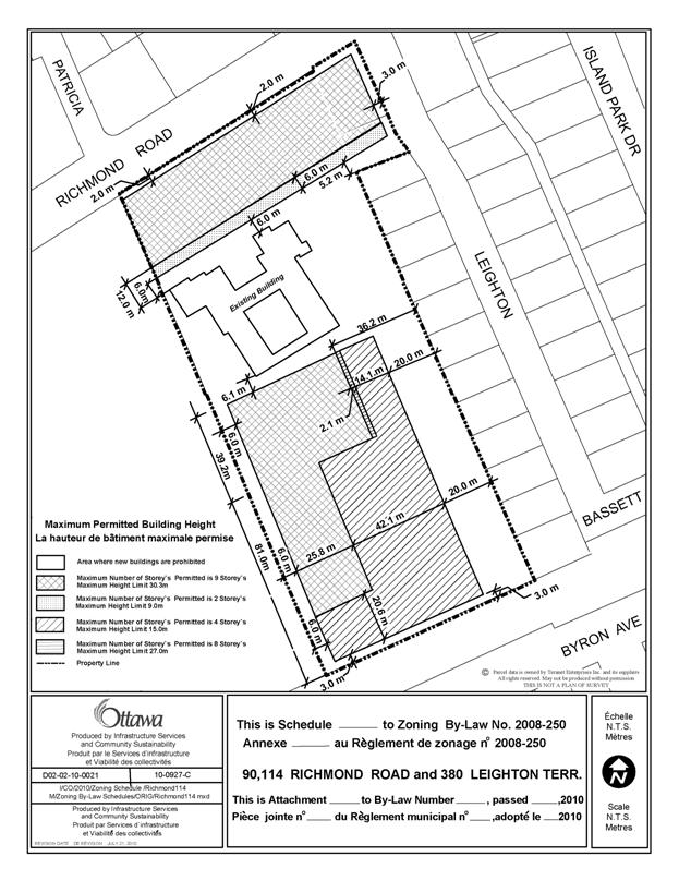
Instead of the provisions pertaining to the parent zones, the height and setbacks are intended to be regulated through a schedule. This document will establish maximum height limits and appropriate setbacks for the development as proposed. They have been established to allow for an adequate separation of uses on site and surrounding properties as well as a transition in building heights. The heights and setbacks shown represent a development envelope and the buildings within this envelope will be further refined through the Site Plan Control process, thereby further decreasing their impact on the surrounding community.
Restriction of Uses
The Department is recommending that specific uses found in the parent zones be prohibited. Public concerns were raised about the possibility of a hotel being located on the site. This use and other uses that the Department believes are not appropriate for the proposed development, namely all forms of rooming houses and a parking structure, are recommended to be prohibited. As well, in the area described on Schedule 2 as being landscaped open space and existing buildings, the Department is recommending that no new buildings be permitted, only the existing heritage buildings, and that the only uses allowed are accessory uses, such as an outdoor patio or a loading space.
Parking and Loading
With respect to parking, the applicant has indicated that the southern part of the property is to be developed with senior’s housing and that given the number of units proposed (260) only 65 parking spaces will be required. While this is a minimum in the Zoning By-law, given the concerns over traffic in the surrounding area and the assumption that seniors are less likely to own a private vehicle, the Department is recommending that the 65 spaces be a maximum for the entire residentially-zoned lands. If for some reason the residential portion of the property is not used for senior’s housing but for regular apartments instead, this will help control the level of traffic to the site in line with those projected by the applicant.
In relation to the Traditional Mainstreet zoning on the property, the applicant is proposing to have the required visitor parking for the residential uses provided as part of the required parking for the commercial uses. The Department does not have a concern with this proposal as the peak times for the uses are different and there will be substantial parking on site to satisfy the requirements of both. It should also be noted that as a heritage building, the adaptive reuse of the monastery will not require any parking.
Depending on the number and size of commercial uses, there could be a large number of loading spaces required, where functionally these could be shared between uses. The Department is proposing to control the location and number of loading spaces through the Site Plan Control process.
Vehicular Access
With respect to vehicular access to the site, the applicant is proposing that this occur at two main points. The access to the mixed-use portion of the development is proposed to be provided from Richmond Road, opposite Patricia Avenue and beside Hilson Avenue School. Vehicular access to the southern portion of the development is proposed to be provided through the Byron Linear Park. The applicant has proposed access through the Linear Park as during the preconsultation process, access from both Shannon Street and Leighton Terrace was discouraged by the residents of those streets. As well, this option is the least disruptive to the open space being proposed on the property. If access to the residential area was to be provided from Leighton Terrace, or perhaps from a second point on Richmond Road, the continuity and functionality of the public landscaped area would be lost, as it would need to accommodate a long driveway to the residential buildings. The only way to preserve the row of maple trees and the overall landscaped area is to provide access to the residential area either via the Linear Park or from Shannon Street. As the paved portion of Shannon Street would need to be widened and the resulting impact on the existing homes would be extensive, the best option to obtain the public benefits that will be derived from the proposal is to have access through the Linear Park.
Providing an access across the linear park is not unlike any of the many roads that currently bisect this park and the Department believes that the public gain from saving the Maple Trees and having the public walkway along the eastern edge of the property more than offsets the access through the Linear Park. As well, by capping the amount of parking to be provided for all uses allowed by the residential R5 zoning to 65 spaces, the impact of this crossing on the park would be minimized. The exact location of the access and its design are issues to be addressed through the Site Plan Control process and the process of the applicant obtaining a license of occupation from the City for the use of parkland. From a zoning perspective, to allow access across the park, Section 100.(1) (c) of the Zoning By-law is recommended to be amended to allow a driveway not to be on the same lot.
Administrative
As the development of the site is to function as a whole, the Department is recommending that a provision be included in the Zoning By-law amendment stating that the lot be considered one for zoning purposes.
Outdoor Patios
As part of the proposed development of the property, it is anticipated that there will be outdoor patios to create animation and friendly people places. It is possible that such a patio may be less than 30 metres from the houses on Leighton Terrace. Patios will be located through the Site Plan process to minimize conflict and sound attenuation measures will be kept in place to mitigate the effect of the patio on the residential uses.
Holding Zone
In addition to the provisions regulating certain uses and performance standards, the Department is also recommending that a holding zone apply to the property. The holding zone, which will prohibit development from proceeding, will only be removed to allow development when a Site Plan Control Agreement is approved and registered on title. Recognizing that the impact of a development on the surrounding community can be greatly influenced by design, the intent of the holding zone is to use the Site Plan Control process to control the design of the buildings, including details on setbacks and transitions in height, to create a development that is compatible with the surrounding community and to respond to the concerns raised by the residents. The provisions for the listing of the holding zone to allow development are provided in Document 3 of this report, Details of Proposed Zoning.
ENVIRONMENTAL IMPLICATIONS
N/A
CONSULTATION
Five public meetings were held with the public and the Ward Councillor. The dates of these meetings were November 23, 2009, January 21, 2010, February 1, 2010, March 10, 2010 and March 31, 2010. Notice of this application was carried out in accordance with the City's Public Notification and Consultation Policy. The City received 67 comments from the public and three comments from Community Associations, all expressing concerns over the proposed development. The issues can be summarized as follows:
- Buildings are too high.
- Too much density.
- Too much traffic.
- Does not conform to the Official Plan or the Richmond Road/Westboro Secondary Plan.
- Not in conformity with the character of the existing neighbourhood.
- Not enough infrastructure capacity to accommodate the proposal.
Detailed responses to the notification/circulation are provided in Document 4.
As part of the Consultation process, the City also engaged a Peer Design Review Panel to comment on and critique the applicant’s proposal. The panel consisted of a landscape architect, an architect and a heritage conservation expert. A copy of their comments and design sketches, resulting from their analysis, are presented as well.
COMMENTS BY THE WARD COUNCILLOR(S):
Byron Pathway - should not be breached. It is one of the few green spaces and path systems that is heavily utilized. By cutting through this resource we diminish the viability of our own City's goals for a higher modal split. This option may have been avoided if the land conveyance was seriously considered from the onset as opposed to the cash-in-lieu option. The cash-in-lieu is only a tool when there is no other option for land conveyance.
The density put forward is significantly higher than the recommended secondary plan that was designed to facilitate intensification along the Richmond Road corridor that was supportable by the existing transportation (road) infrastructure. This site should not be looked at in isolation. This particular block face will see close to 900 units exiting onto Richmond Road within one block of the Island Park Drive intersection which has been at failure for some time. Island Park Drive is over-taxed and cannot support any increases as it will continue to be the only western interprovincial crossing for decades to come.
The impacts of this development at this density and height if accepted will permanently and irrevocably alter the very nature of the community, its liveability and sustainability that is counter to the intent of the provincial policy statement and the official plan that seek appropriate intensification.
Intensification is not a rationale for over intensification. This is one the few sites in the city that has clear guidelines on appropriate intensification levels as it is based on recent planning intensification supportive documents.
It is the responsibility of the City (staff and council) to guide and ensure intensification is implemented in a fashion that is supportable. We as stewards of the City on behalf of our residents are empowered to follow and implement sound planning principles. To do less than that, we are not improving our city and communities but creating an unsustainable environment at a high cost to taxpayers as we strive to mitigate the results of poor planning.
The high level of intensification is unique to this ward and is not widely experienced. This community has accepted sound and appropriate intensification. Intensification does not mean that it should be done at any cost.
The arguments suggested by the planning department is that there is no maximum to intensification. But an appropriate level of intensification is in reality based upon our existing infrastructure. As councillors we should ensure we do not overload our infrastructure to the extent that no future intensification can take place in its localized proximity. Our capacity is not infinite but the statements offered by Planning would suggest otherwise. We know this not reality.
LEGAL/RISK MANAGEMENT IMPLICATIONS:
If the staff recommendation is adopted and the resulting by-law is appealed to the Ontario Municipal Board, it is anticipated that a one week hearing would result. Staff from the Planning and Growth Management Department would be able to provide evidence on behalf of the City.
If the zoning amendment request is refused, reasons will have to be provided. Should the refusal be appealed to the Ontario Municipal Board, it is expected that a two week hearing would result. Depending on the reasons identified, up to three outside witnesses would need to be retained (Planning, Transportation, Infrastructure). The estimated cost for the retention of such witnesses is in the range of $45,000 to $110,000.
CITY STRATEGIC PLAN
Objective 1, Manage growth and create sustainable communities by:
· Becoming leading edge in community and urban design
· Ensuring that new growth is integrated seamlessly with established communities
· Ensuring that community facilities are built in tandem with new development
· Evaluating the impact of policy and development decisions on communities
TECHNICAL IMPLICATIONS
N/A
FINANCIAL IMPLICATIONS
There are no direct financial implications associated with this report.
APPLICATION PROCESS TIMELINE STATUS
This application was not processed by the "On Time Decision Date" established for the processing of Zoning Amendments, due to the undertaking of a peer review by a design panel.
SUPPORTING DOCUMENTATION
Document 2 Height and Set back Schedule
Document 3 Details of Proposed Zoning
Document 4 Consultation Details
Document 5 Peer Review Panel Comments
Document 6 Peer Review Panel Proposal Sketches
Document 7 Statement of Cultural Heritage Value
DISPOSITION
City Clerk and Solicitor Department, Legislative Services to notify the owner, applicant, OttawaScene.com, 174 Colonnade Road, Unit #33, Ottawa, ON K2E 7J5, Ghislain Lamarche, Program Manager, Assessment, Financial Services Branch (Mail Code: 26-76) of City Council’s decision.
Planning and Growth Management to prepare the by-law adopting the Zoning Amendment, forward to Legal Services, and undertake the statutory notification.
Legal Services to forward the implementing by-law to City Council.
LOCATION MAP Document 1
Maximum Permitted Building Heights Document 2
Details of Proposed Zoning DOCUMENT
3
Proposed Changes to the Comprehensive Zoning By-law
The subject properties are to be rezoned from I1A, TM[83] H(15) and R1MM[762] to a TM[1763] S256-h and a R5B[1763] S256-h as Shown on Document 1.
A new Exception, TM[1763] S256-h and R5B[1763] S256-h, is added to Section 239 and will include in effect, the following:
Land Uses Prohibited in Column IV:
In lands zoned TM[1763]S256 the following uses are prohibited:
· Hotel;
· Above ground parking garage;
· Parking lot as a principle use;
· Rooming House;
· Rooming House Converted.
In lands zoned R5B[1763] S256 the following uses are prohibited:
· Rooming House;
· Rooming House Converted;
· Shelter.
Provisions of Column V
- All new buildings must be located within the hatched areas shown on Schedule 256 (Document 2) and subsection 164(1) Table 164A Row X, Columns VII through XII inclusive of Row X and subsection 197(3) Table 197 Rows (c) through (g) inclusive and subsection 197(4) do not apply.
- No new buildings are permitted in the area described as “Area Where New Buildings are Prohibited”, on Schedule 256 Document 2.
- Despite the above provisions:
(i) permitted projections are allowed in the area described as “Area Where New Buildings are Prohibited”.
(ii) a building located within the hatched area to the south of the existing building on Schedule 256 (Document 2) may be connected to the existing building on the lot by a structure having a maximum height of nine metres, a maximum width of 41.2 metres and a maximum length between the buildings of 11.4 metres. This structure may only connect to the southerly wall of the existing building structure and must be made of transparent material.
- The maximum permitted building heights are set out on Schedule 256 (Document 2).
- The subject properties are to be considered as one lot for Zoning By-law purposes.
- The lot line abutting Richmond Road is deemed to be the front lot line.
- Part 17, Schedules, is amended by adding Document 2 as Schedule 256.
- Despite Section 100(1)(a) parking spaces for non-residential uses within that part of the lot zoned TM[1763] S256 may be included in the calculation of and used as visitor parking spaces for the residential uses on the lot.
- The maximum permitted total cumulative number of parking spaces, including required visitor parking, for all uses located within the R5B[1763] S256 zone, is 65.
- In the R5B[1763] S256 zone all dwelling units located on the ground floor of a building and containing windows facing the rear lot line or an interior side lot line must have their principal access oriented towards that lot line.
- Within the hatched area located to the north of the existing building on Schedule 256 (Document 2) all non-residential uses located on the ground floor of a building must have direct pedestrian access to the outdoors.
- Vehicular access to the lot may be provided by a driveway running through the Byron Avenue Linear Park.
- Section 85(3)(a). does not apply.
- Section 113. does not apply.
- The holding symbol will not be removed until such time as:
§ An application for Site Plan Approval has been approved and a Site Plan Agreement is registered on title.
§ As part of its approval of the Site Plan, the City requires, in addition to any other requirements not specifically listed herein, the following:
o Public rights-of-way and easements over all the lands described on Schedule 256 as “Area Where New Buildings are Prohibited” and not occupied by permitted projections or occupied by outdoor commercial patios;
o Two separate public rights of way to be established through the mixed-use commercial building along the Richmond Road frontage. One passageway must be a minimum of nine metres wide and the other must be a minimum of six metres wide. They both must be a minimum of eight metres high;
o A substantially landscaped public walkway from the Byron Street Linear Park to Richmond Road. As part of this walkway, the existing row of mature maple trees must be preserved and incorporated into the pathway system;
o Additional Landscaping on the subject property must be provided where appropriate and new trees must have a minimum caliper of 70 mm, unless otherwise specified;
o The ground floor uses of the buildings to be built along Richmond Road must have direct access from the ground floor on both the Richmond Road façade and the southern façade facing the historic monastery;
o Vehicular access to the property must be provided in a safe and functional manner. The location of vehicular access must be approved by the City;
o The Owner agrees to undertake and pay for any required modifications to the road network affected by the proposal;
o With a view to incorporating the characteristics found along Traditional Mainstreets in Ottawa and the surrounding neighbourhood, the facades of all buildings will be subject to Site Plan Control Approval and will be reviewed with respect to materials, colours, complementary building finishes, exterior treatments, the incorporation of podiums, setbacks, transitions in height, changes in relief, overall design and the Secondary Plan Built Form Guidelines for Westboro Village and East Village;
o If the building on Richmond Road is all one height in metres, or the same number of storeys, the building on Richmond Road must be designed to look like a minimum of three different buildings;
o Assurance that parking is provided in accordance with the Zoning By-law, as amended, but not in an abundance so as to result in a reduction in the use of alternative forms of transportation.
o The determination as to whether the above-noted Site Plan requirements have been fulfilled shall be to the satisfaction of the General Manager of Planning and Growth Management or Planning and Environment Committee, whichever the case may be.
CONSULTATION DETAILS DOCUMENT 4
Notification and public consultation was undertaken in accordance with the Public Notification and Public Consultation Policy approved by City Council for Zoning By-law amendments. Sixty-seven comments were received from the public and three comments were received from Concerned Community Groups, all expressing concerns of the proposal. Five separate preconsultation public meetings were also held in the community to discuss the proposal. A summary of the comments received from the Public Notification and Public Consultation Policy circulation and a response to them, is provided below.
As part of the Consultation process, the City also engaged a review panel to comment on and critique the applicant’s proposal. The panel consisted of a landscape architect, an architect and a heritage conservation expert. A copy of their comments and design sketches, resulting from their analysis, are presented as well.
SUMMARY OF PUBLIC INPUT
1. The applicant does not propose an actual zoning for their development. There is not enough detail to provide an understanding of the possible implications of the zoning.
Response
While the applicant did not specifically request a particular Traditional Mainstreet or Residential zone for their development proposal they did have a specific concept design displaying such things as the location and height of buildings, vehicular access points, landscaping, the number of units and amount of commercial space. The applicant provided an extensive planning rationale and technical studies to support their rezoning proposal, which are posted on the City’s website. Through the refinement of their proposal, City Staff have selected the appropriate zoning labels to best reflect the recommended development.
2. The proposed development, which comprises approximately 700 units, is too much. It would meet intensification targets for the Westboro Area for the year 2031.
Response
The population intensification targets found in the Community Design Plan and Secondary Plan for Richmond Road/Westboro are not absolutes but projections based on estimated potential. Densities are permitted to go beyond those projected by the Community Design and Secondary Plan. Intensification targets found in the City’s new Council-approved Official Plan, as further detailed in the Residential Land Use Strategy, represent minimums; there are no maximums to residential intensification.
3. The proposed height, up to 12 storeys, is far too high in relation to surrounding developments.
Response
As presented in this submission, the height of the proposed development satisfies the policies in the Official Plan and the Secondary Plan for Richmond Road/Westboro. Maximum building heights have been revised down to nine storeys as part of the changes made by the applicant to better respond to policy direction.
4. The plan is intensive and inconsistent with design guidelines provided by the City for potential purchasers. This is not fair to the other purchasers.
Response
The Guidelines provided to potential purchasers of this property by the City relate to numerous factors of development, such as heritage considerations, Official Plan and Secondary Plan policies and infrastructure capacity. Despite how some people may view the guidelines or interpret what was presented in them, whoever would have bid successfully for the property would have the ability to submit a development proposal and have that development proposal evaluated by the City in relation to applicable Official Plan and Secondary Plan Polices to determine if it was appropriate.
5. I oppose the proposed access from the Byron Linear Park, this should not be allowed.
Response
Access through to site from the City’s property will be determined by City Council through a separate process and is not part of this rezoning application.
6. The proposed development plan does not provide adequate views of the historic buildings on the property.
Response
While the buildings on the property served as a monastery for approximately the last 100 years, there has been no public view provided to them. With this proposal, the historic buildings and a large portion of the site will be open to view and accessible by the public. Along Richmond Road, the development proposal offers a “view of discovery” from the street and will provide for two separate public accesses directly to the site and its historic buildings.
7. The applicant has misrepresented the plan when he says there is approximately 50 percent open space.
Response
The proposal actually does represent a development having approximately 50 percent open space. As well, the applicant has revised his plan to preserve existing significant landscaping along the eastern edge of the property and will be providing a public landscaped pathway with significant landscaping, as a pedestrian access from Byron Avenue to Richmond Road.
8. The amount of parking proposed for the development is insufficient.
Response
The applicant is providing parking in accordance with the requirements of the Zoning By-law.
9. The traffic resulting from this development and other new developments in the surrounding area will only make the existing traffic problems even worse.
Response
As presented in this submission, a transportation study submitted by the applicant and reviewed by City Staff, indicates that the traffic anticipated by this proposal will not result in any significant negative impacts on the existing road system. The modifications recommended to the existing road network as part of the transportation analysis are intended to facilitate the efficient distribution of traffic to and from the site with minimal changes to the existing road network.
10. The proposed development will ruin the village feel of Westboro.
Response
The policies of the Official Plan and the Richmond Road/Westboro Secondary Plan were established to guide the development of buildings in Westboro. As presented in this submission, it is the Department’s position that the proposed development satisfies these policies and therefore will not ruin the intended village feel of Westboro.
11. I have a concern that the existing municipal infrastructure cannot accommodate the proposed development.
Response
An analysis undertaken by Staff concerning municipal infrastructure has indicated that there are no capacity issues regarding the intensity of the proposal.
12. The trees on the site must be preserved.
Response
The applicant is proposing to preserve as much of the existing vegetation as possible, including a row of existing maple trees along the eastern boundary of the site, which will form part of a pedestrian pathway.
13. A hotel is not an appropriate use for this property.
Response
A hotel is proposed to be prohibited by the recommended zoning.
14. The proposed development does not satisfy the applicable policies of the City’s Official Plan, the Secondary Plan or the Community Design Plan.
Response
As presented in this submission, it is the Department’s position that the proposed development does satisfy the applicable policies and direction of those documents.
15. The buildings on the southern portion of the property are too high.
Response
It is the Department’s position that the buildings proposed for the southern portion of the property are in accordance with the height of buildings anticipated by the Official Plan and the Secondary Plan.
16. If the house on Leighton Terrace owned by the applicant is to be torn down, it will lead to further such intensification along the street.
Response
The house to be demolished is part of this development proposal; it does not mean that the same thing will occur to other single detached houses along the street.
17. If the existing wall around the monastery is demolished, it will simply be replaced by a new wall of development.
Response
The proposed development will have extensive publicly accessible open space with various points of access. Instead of creating a development wall around the property, it will create the opportunity for discovery and be inviting to the public.
18. This development proposal is just a money grab at the community’s expense.
Response
The amount of money the site cost or the amount that will be generated from the development is not and has never been a consideration of planning approval.
19. How can the Developer believe that their proposal is accepted by the majority of the area residents?
Response
It does not matter what the Developer believes, the development proposal is evaluated on its planning merits.
20. I am concerned over the increase in traffic on the safety of my children. This will be of particular concern along the Byron Linear Path with vehicles proposed to cross the pathway to enter the site.
Response
People driving to and from the site are expected to drive in accordance with rules and regulations established by appropriate legislation, such as the Highway Traffic Act. Through the Site Plan Control process, access to and from the site can be designed and provided so as to minimize vehicle/pedestrian conflicts.
21. The shadowing impacts from the proposed development will negatively impact the play area of Hilson Avenue School.
Response
The grassed play area for Hilson Avenue School is located adjacent to Richmond Road. While there will be some shadowing impact along the eastern edge of this grassed area, this impact is minimal and will have disappeared by noon, even in the winter months.
22. Noise and pollution from cars entering the site from Richmond Road will be bad for the children playing at Hilson School.
Response
The play area is located along Richmond Road, which is an Arterial Roadway already carrying a high volume of cars. The additional vehicles travelling to and from the site are not expected to create by themselves an unsafe pollution situation for the children playing in the school yard.
23. There will be a loss of privacy for existing residents.
Response
The setbacks provided are intended to help maintain the privacy of existing residential dwellings. The buildings proposed have been moved further from Leighton Terrace to help preserve the privacy that currently exists.
24. The proposed development will increase the amount of hard surface and the possibility of flooding in the area.
Response
Stormwater runoff is a concern that will be addressed at the time of Site Plan Control Approval.
25. The proposal does not respect the recent heritage designation of the property.
Response
While the subject property is currently in the process of being designated under the Ontario Heritage Act, the applicant has the ability to file an application for consideration by the Conservation Review Board and City Council to alter the designation, to permit the development. Ultimately City Council would decide if the proposal to alter the property under the Ontario Heritage Act was appropriate.
26. What about a noise study?
Response
A noise study is a consideration of the Site plan Control Process and would ensure that the interiors of the proposed development were not negatively affected by exterior noise sources.
27. I don’t like that people will be living next door staring down into the school.
Response
In an urban setting residential development is often located next to school sites. The setbacks proposed will help maintain a separation between uses.
28. This proposal will disrupt the integrity of Shannon Street.
Response
No access is proposed from the subject property to Shannon Street. It is the Department’s position that the setbacks proposed will allow for an adequate separation between the existing homes on Shannon Street and the proposed development.
COMMUNITY ORGANIZATION COMMENTS
Comments were received from three Community Associations, each expressing concerns. A summary of their comments and a response to them are provided below.
Wellington Village Community Association
The Wellington Village Community Association welcomes a thoughtful, sustainable and community-oriented redevelopment of the Sisters of the Visitation convent property. Indeed, we welcome new residents to our community, and the activity and life these people and businesses will bring to this stretch of Richmond Road.
However, we feel that any redevelopment must respect the character of the existing community and the heritage values of the site, and we have serious concerns about whether the proposal by Ashcroft Homes does so.
In creating their proposal, Ashcroft virtually ignored the valid, thorough planning work that occurred prior to their bid for the site, and of which they had full knowledge. The Secondary Plan covering the area around the site clearly outlines the intensity of development expected should the site be redeveloped. The Plan specifically identifies this parcel, and recommends a Traditional Mainstreet density along Richmond Road, no more than six storeys in height, and no more than four storeys on the rest of the site.
Ashcroft’s “Planning Rationale”, submitted with its rezoning application to the city, is a lengthy and belaboured attempt to spin a story to justify its proposed eight-to-twelve storey development, when the city’s planning guidelines – developed in partnership with community members -- are there to read in black and white in the secondary plan.
Our specific recommendations and concerns are as follows:
· We endorse the heritage designation for the whole property, and hope that any proposed development for the site gives serious consideration to its heritage values.
· We would like to see the plan revised to leave the area between the convent buildings and Richmond Road as a small park or plaza, instead of blocking sightlines to the buildings.
· We expect the city to insist that Ashcroft carefully manage traffic to the Byron Avenue side of the site, including compensating measures should approval be granted for any interruption of the Byron Avenue Tramway Park pathway, to which the WVCA is opposed.
· We would like Ashcroft to clarify whether or not a hotel will be built on the site, and if not, what is expected to take its place.
· We would like to see more sustainable features on the site, including parkland, renewable energy sources and alternative transportation options.
· We hope that Ashcroft will embrace a reuse of the convent buildings that enhances the community and brings new and interesting businesses or activities to the neighbourhood.
Hampton Iona Community Group
114 Richmond Road is located within the boundaries of the Hampton Iona Community. The Hampton Iona Community Group (HICG) has followed the proposed development closely and in fact anticipated this development by ensuring that the Community Design Plan (CDP) drafted in 2007 and the Richmond Road/Westboro Secondary Plan (SP) reflected the concerns of the neighbours and provided direction for the redevelopment and intensification of the site. HICG is onside with the City’s goal of intensification in Westboro but intensification needs to be respectful of the community and at acceptable levels. Our participation in the CDP process was to help insure that this happened and so that residents could achieve buy-in with respect to intensification
Based on significant input from the community and our previous history with the preparation of the CDP and SP, HICG is greatly concerned that the level of intensification being proposed by Ashcroft is much too high for the immediate neighbourhood and will result in Westboro meeting its 2030 intensification targets once the development is completed but without infrastructure required to support this intensification. This could affect the rights of other property owners and future development in the neighbourhood. The heights and building densities being requested by Ashcroft are significantly higher than that allowed in the CDP and SP and envisioned by the community and are not compatible with the character of the surrounding neighbourhood. The levels of density and building height will overpower the Convent building and will not allow the heritage of the building or the site to be properly recognized or appreciated.
HICG is onside with the entire site receiving heritage designation and we recognize that while this designation will inform any planned development, such designation does not prevent development. We consider the need for clear (even if not complete) sight lines of the convent building from Richmond Road and Byron Avenue as part of the heritage requirements and to return this building to the community. While the convent has been cloistered for almost 100 years, it has been open to the public on a limited basis in a variety of ways and has always formed part of our community.
HICG has no objection to the site being zoned for mixed use and developed accordingly. We are concerned the mixed use zoning could easily allow for uses that are not now contemplated (such as a hotel) but could easily be substituted with no rezoning required. This type of substitution was previously done by the same developer at 111 Richmond Road.
We are pleased by Ashcroft Homes’ plan to open the site to pedestrian and bicycle traffic, linking Byron Avenue to Richmond Road. We are also pleased that they are interested in various adaptive uses of the convent that will benefit both the local and wider communities but we do not see the adaptive use of the convent as a sufficient trade-off to allow for inappropriate densities or building heights on the site.
We are concerned with the level of traffic that will be generated by the site and the impact that this will have on residential streets, particularly Byron Avenue, Kensington Avenue, Brennan Avenue, Hilson Avenue and Leighton Terrace. We are also concerned that the seemingly limited underground on-site parking will result in overflow parking on these same side streets. We also believe that there are several shortcomings in the Delcan traffic study.
Much of the community does not consider an access road onto Byron Avenue as appropriate as it will result in the loss of valuable parkland along the Byron Tramway Park, break up the continuity of this park and could potentially be a safety hazard to the numerous pedestrians and cyclists of all ages who use this park in general and as a commuting route to area schools (Hilson Public School, Elmdale Public School and Churchill Alternative Schools) specifically. Very little thought has gone into the safety aspects of this access road nor is Ashcroft providing any benefit to the community for taking over public park land.
Westboro Community Association
The Westboro Community Association does support both commercial and residential intensification. However in this case we have some concerns for the proposed mixed-used zoning for this site.
As you know the WCA participated in the Westboro/Richmond Road Community Design Plan and sought and received approval for a Secondary Plan which has been approved by the OMB. During the CDP process we asked for triggers that would result in a review of what is being proposed. It appears that those triggers were not implemented or have been ignored. As such Councillor Leadman at an earlier public meeting informed the community that we are now at 104% of the projected population for 2021 and that this proposal if left unchecked will add another 700 units (per the developer). Unfortunately very little has been done to address transit, parking or infrastructure issues.
We feel that too much is happening far quicker than anticipated and that traffic is an ever increasing issue that no one seems to want to address. The lack of specifics with this application is also of concern. Another important issue is the cumulative impact of the proposed project in terms of increased traffic when combined with two other properties by the same developer in the same area. The CDP/Secondary Plan is being ignored or trivialized and that has to stop. We therefore conclude that in the absence of more specifics on how issues such as increased traffic will be addressed as well as the fact that the proposed development will create an unwelcome canyon effect on Richmond Road, the WCA is strongly opposed to this general request for a re‑zoning and also suggest that a moratorium be placed on this and future development along Richmond Road until previously noted issues are addressed not by specific site but for the area covered by the CDP
Response to Concerns from Community Associations
The concerns raised by the three Community Associations relate to the compatibility of the proposal, in relation to the surrounding community. They each want a development that respects the character of the existing community and that can be integrated into the community with the least amount of disruption to existing infrastructure. The Department understands the concerns raised by the three Community Associations and has included provision in the approval (e.g. holding zone) that will help ensure that the development responds positively to their concerns and becomes what they envisioned for the site.
Peer Review Panel Comments Document 5
Les Soeurs de la Visitation Convent
114 Richmond Road, 90 Richmond Road, and 380 Leighton Terrace
Peer Review Panel Comments:
June 21, 2010
Background
The Panel was requested by the Planning and Growth Management Department of the City of Ottawa to review and comment on the submission for 114 Richmond Road, 90 Richmond Road, and 380 Leighton Terrace.
The Panel consists of three professionals, representing the fields of architecture, landscape architecture and heritage conservation.
· David Pontarini, architecture
· Greg Smallenberg, landscape architecture
· Michael McClelland, heritage conservation
The Panel was provided with the following information:
· Basic Site Plan and Design Principles for Redevelopment of 114 Richmond Road August 2009
· Heritage Survey and Evaluation Form – 114 Richmond Road
· Statement of Cultural Heritage Value – The Soeurs de la Visitation, 114 Richmond Road
· Designation Report – Ottawa Council March 09, 2010
· City of Ottawa Official Plan Amendment X – Land Use
· City of Ottawa Official Plan Amendment – Document 2 – Land Use
· Urban Design Guidelines for Development along Traditional Mainstreets
· Residential Land Strategy for Ottawa 2006-2031
· Ashcroft Homes - Preliminary Concept document, May 28, 2010
· Ashcroft Homes - Planning Rationale
· FoTenn for Ashcroft Homes - Key Policy Framework document, May 28, 2010
· +VG for Ashcroft Homes - Interim Cultural Heritage Impact Statement
· A tree inventory
· Island Park Community Association presentation document, June 11, 2010
· Hampton-Iona Community Group presentation document, June 11, 2010
The Panel also held a series of informative interviews with the proponent team, with City staff, with the local Councillor and with representatives of the Island Park and Hampton-Iona communities.
Response to Context
The Panel noted the unique location and inherently complex characteristics of the site; a large 5.46 acre lot containing historic resources, located adjacent to a stable low rise single-family neighbourhood, fronting onto a Traditional Main Street that is undergoing a new wave of intensification and redevelopment. The panel recognizes the complexity associated with redeveloping this unique site.
1. The Panel feels that the strategy for intensifying and redeveloping this site needs to balance a carefully considered approach to the three key elements of this site.
a. The existing stable residential context to the east and south of the site
b. The heritage buildings and portions of the surrounding landscape
c. The traditional main street, Richmond Road, which forms the northern boundary line of the site.
2. The proposed buildings are currently designed to step away from the surrounding low-rise residential neighbourhoods, in some case at the expense of the heritage resource. The heights of the buildings adjacent to the residential areas have for the most part been kept low, with most of the height being located adjacent to the Convent.
3. The Panel feels that the proposed development needs to better support and more carefully respond to the heritage structures and portions of the existing landscape.
4. The proposed condo building that fronts onto Richmond Road and creates a continuous street wall has been designed to step back as it rises to the west up to 12 storeys, however, other possibilities for responding to Richmond Road should be considered in order to relieve some of the pressure placed on the Convent. The transitions on the south side of the mixed‑use building along Richmond Road need to step down and back away from the Convent in a more significant way
Site Plan Design
1. An alternate site plan that establishes a much wider landscape area along the east property line and includes the row of mature maple trees should be considered. Repositioning and / or consolidation of the buildings in the south quadrant to create a larger green open space, framed by built form and mature landscape, could vary the open space offerings of the overall development, reference the historic landscape of the Convent, provide more permeable surface to assist in ground water / storm water management, relax the relationship of the proposed building and the single family homes along Leighton Terrace and reinforce the strongly supported idea of a publicly accessible path from Byron Avenue to Richmond Road along the east property line by embedding the pathway within a thicker, mature landscape
2. Notwithstanding the philosophy expressed for obscuring the heritage house from an open Richmond Road view, slight variations on the portal location, particularly westward to reveal a bit more of the principal heritage house, should be explored. An additional, more intimately scaled pedestrian portal located west of the main portal being proposed could be considered. This would offer an additional way of penetrating the site from Richmond Road both physically and visually and could potentially create more activity in the courtyard space.
3. The site has two primary frontages along Richmond Road and along Byron Ave and a smaller frontage along Leighton Terrace. A fourth frontage exists at the end of Shannon Street, but has not been deemed a workable point of access to the site
4. The Richmond Road frontage will have one curb cut at the west end of the frontage for vehicle access to below grade parking. No curb cuts are being proposed along Leighton even though it would normally be considered a prime location for a curb cut as a secondary street connecting to a main street. No curb cut has been provided here in response to a request by the area residents. A curb cut has been proposed along Byron to provide a separate vehicle access point for the southern half of the development. The details of the design of this access point and its long –term impact on the Byron Ave linear park needs to be refined but is generally supported by the panel.
5. The arrangement of courtyards as a gesture to the historic patterns of open space on the site is interesting. This idea could be carried further by the creation of several transitional points within courtyard sequencing. Most of the proposed courtyards will likely be characterized by the built edges that form their respective edges and due to the diversity of architectural styles, both of the heritage buildings and the proposed new buildings, the courtyard idea could be made more vital if they responded in kind to these variations.
6. Consideration to repositioning Building #8 away from the Convent building should be given. In this instance, opportunities to enter into the heritage cloister garden from an external pathway system could be interesting and allow the cloister garden to become more a part of the open space experience of the development.
Building Form and Articulation
1. The Panel feels that careful consideration should be given to the following;
a. The current massing should be reviewed with particular attention being paid to the location of the highest building elements, currently located in the north east quadrant, adjacent to the Convent.
b. Consideration should be given to placing the tallest mass along Richmond Road, stepping down to the heritage resource and the single family homes along Leighton Terrace.
c. The rental building in the middle of the site should be pulled away from the heritage resource. This building, although higher than the other buildings in south quadrant of the site, should also setback and step back from the heritage resource in a more significant way.
d. The four-storey building adjacent to the row of mature maple trees should be reconsidered. The development team should consider eliminating this building altogether or shifting it further west in order to provide more space between the maples and any new buildings that are built in the south half of the site.
2. The building needs to be ‘massed harmoniously into the area’ which in this case means away from the low-rise residential areas to the east and south of the site with higher elements along the west and north boundaries.
3. The current scheme places the tallest portions of the buildings immediately adjacent to the heritage resource. The height of the buildings adjacent to the Convent should be lower and the building mass should set back and be stepped back away from the north and south faces of the existing Convent. In addition the portions of the buildings that are adjacent to the Convent should be kept low, stepping up in a gradual way to taller building forms.
4. The density and mass of the buildings on the north side of the site should be pushed away from the Convent, and positioned closer to Richmond Road. Consideration should be given to having the Richmond Road building designed to be a more consistent height along its entire frontage, extending from the west end of the site to the east end of the site. The developer indicated that a consistent street wall building with a height of 10 floors would be the equivalent density of the current 12 storey stepped building. The 10 storey building could be broken down both vertically and horizontally in order to reduce its mass. With a significant setback of any upper floors above eight floors away from Richmond. The east and west end of the street wall building could then terrace down towards the north side of the Convent building at the west end and the existing single family houses adjacent to the east end of the building.
5. An alternate site plan that establishes a much wider landscape area along the east property line (to include the row of mature maple trees) should be considered. This could be achieved by shifting or repositioning and / or consolidating the buildings in the south east quadrant to create a larger green open space, framed by built form and mature landscape, As mentioned above, this could vary the open space offerings of the overall development, reference the historic landscape of the Convent, provide more permeable surface to assist in ground water / storm water management, relax the relationship of the proposed building and the single-family homes along Leighton Terrace and reinforce the strongly supported idea of a publicly accessible path from Byron Avenue to Richmond Road along the east property line by embedding the pathway within a thicker, mature landscape. The east building could be shifted further east by tightening up the courtyard between the two north-south bar buildings that currently face each other. Alternatively the four-storey mass on the east side could be eliminated altogether with some of the density being shifted on to other buildings on the site.
6. This would enhance the current landscape and improve the open space ratio, which exceeds the minimum area required, but seems rather low for a site of this size and significance.
1. Pedestrian Realm and & Landscaping Strategy
Notwithstanding the developer’s remarks regarding the difficulties in tree retention on site there is a significant inventory of existing mature trees on the property that should be considered in the further development of the proposed site plan. In particular, an impressive north-south row of maple trees aligning approximately parallel to the east property line could potentially make a strong contribution to the estate quality of the site while recalling some of the history of the Convent’s south lawn and mature perimeter landscape. It should be noted that mature trees contribute a great deal to storm water management through the process of evapotranspiration and could be helpful in this regard given concerns for storm water management in this area.
2. A tree inventory and arborist report is requested for review. It would also be helpful to see the tree survey overlaid with a line drawing of the current site plan to examine where opportunities for tree retention might be possible. Although the developer noted difficulty in preserving existing trees during construction, partly because of ground water table changes resulting from excavations etc., there are a number of proven tree protection strategies that minimize tree loss in these instances and they should be considered.
3. Initial details describing a strategy to protect the large existing maple tree, shown as a part of the site plan proposal in the courtyard area east of the Convent building, would be helpful. In particular it would be useful to understand the proposed grades in this area in relationship to the existing grade at the base of that particular tree.
4. The proposed portal into the site from Richmond Road is an interesting feature and, as discussed with the proponent design team, could be detailed in ways that draw people into the site from the sidewalk. Wrapping the proposed Richmond Road retail façades south into the portal towards the courtyard was discussed as an idea worth pursuing and it would be helpful to see some illustrations of this approach.
5. The arrangement of courtyards as a gesture to the historic patterns of open space on the site is interesting. This idea could be carried further by the creation of several transitional points within courtyard sequencing. Most of the proposed courtyards will likely be characterized by the built edges that form their respective edges and due to the diversity of architectural styles, both of the heritage buildings and the proposed new buildings, the courtyard idea could be made more vital if they responded in kind to these variation.
6. Consideration to repositioning Building #8 away from the convent building should be given. In this instance, opportunities to enter into the heritage cloister garden from an external pathway system could be interesting and allow the cloister garden to become more a part of the open space experience of the development.
Heritage Preservation
1. The Interim Cultural Heritage Impact Statement issued by the proponent team describes impacts which could adversely affect the heritage value of the site as:
a. “Height, massing and scale around heritage sensitive areas especially the cloister garden, the chapel and the house.
b. Building setbacks at the above sensitive areas could have negative impacts if they are insufficient.”
2. The Panel agrees with this assessment. The location of the heritage resources has a major affect on how new buildings can be massed on the site. The sun shadow studies show that the cloister is significantly affected by the proximity of the proposed built form to the south. And the design of that attached built form demolishes portions of the Convent, including the south wing of the Convent. These are negative impacts and they should be avoided as the design moves forward.
3. The Planning Rationale report (March 2010) refers to the proposed south building as a hotel, with the Convent itself being for community purposes with commercial on the third floor. This hotel programme may have influenced the design of the proposed building and its siting so close to the Convent, including a proposed pool to the west of the Convent, but it is our understanding that this programme has now changed. We feel that any height of the building to the south should be distanced from the Convent and, most importantly, that a clear and strong idea for the adaptive re-use of the Convent needs to be developed as a component of the site plan application.
4. The building to the north of the Convent, facing Richmond and backing onto the Convent, comes very close to the Chapel. This relationship is not shown in the relevant Section F and needs to be addressed.
5. The Panel understands that there will be alterations proposed to the heritage structures for its adaptive reuse and possibly even carefully considered connections between the Convent and the new development. These can only be based however on a developed concept for reuse, a clear description of programmatic needs and a thorough heritage impact assessment.
6. The heritage significance of the site is rich. There is the Gothic Revival house, called The Elms, that sits on a small rise of land, and there is the later Convent structure with the Chapel. In their historic orientation, the house was entered from the east and the Convent was entered from the west. The differences in character of these structures need to be clearly understood and reflected in any proposed alterations to them or their setting. While the proposed plan describes a series of community spaces, a clearer definition of interlinked spaces needs to be developed, in particular around the heritage complex. This could include intimately scaled routes around the Convent, possibly with a pedestrian connection to Richmond, distinct from the portal. This immediate landscape could adopt some of the character of the gardens to the north of the Convent. The Panel would encourage considering, depending on the adaptive reuse of the Convent, whether the central cloister courtyard itself might link up with these defined community spaces.
7. To the south the Panel is clear that a larger portion of land needs to be retained for the pedestrian route to Byron Avenue. The large row of maples should be retained allowing for a stronger sense of the scale of the Convent’s estate and gardens to be retained. This would be in contrast to the more intimate scale of the gardens immediately around the sides of the Convent.
8. The conservation of the heritage resources of the site is a significant undertaking. As the project goes forward it will be crucial that the implementation process for this conservation be developed. The heritage resources of the site are important public assets that can only be secured, as a long-term proposition, through a successful development of the property.
Sustainable Design
1. The Panel feels that this issue should be carefully considered as the development proceeds and recommends that the proponent continue to develop the sustainability strategy to make the development a model for infill development along traditional main streets.
Response to Comments from Peer Review Panel
The Department has reviewed the comments from the Review Panel and with the applicant has incorporated the ones considered to be appropriate. These include:
- The creation of a wider landscaped area and the preservation of the mature trees along the eastern side of the property.
- The creation of a second portal through the mixed-use building along Richmond Road, to create more exposure to the Heritage Building.
- The building to the south of the monastery, which was proposed to be connected, has been moved six metres away and is terraced to minimize impact on the monastery.
- The building heights along Richmond Road have been lowered and the building mass is terraces away from the monastery.
- The building along Richmond Road steps down to the Elms and the monastery and to the buildings along Leighton Terrace.
- By saving the row of maple trees, the buildings in the rear of the property have been setback further from the buildings on Leighton Terrace.
- Uniform heights but the design of the building is to read as a minimum of three buildings.
Other points will be dealt with through the Site Plan Control process, such as:
- The design of the curb cut to provide access from Byron Avenue, (if it is permitted by City Council).
- Transitional points within the Courtyard sequencing.
Recommendations of the Review Panel not incorporated into the zoning are not eliminating a building on the southern portion of the property to create a larger landscaped area and buildings in the form of a “C”. It was felt that the proposed landscaped area in the “C” could not be well defined as public or private space and that a building at this location, with open space in the middle, for the surrounding buildings, was more appropriate.
As part of the Site Plan Control Process, the Peer Design Review Panel will be further engaged to evaluate the applicant’s proposal and provide advice and guidance on such issues as the design and location of buildings and public open spaces, including landscaping. Their input will help determine the programming and functioning of the overall development and will be used to help finalize Site Plan Control Approval and ultimately, the lifting of the holding provision recommended for the rezoning.
Design Review Panel Sketches Document 6
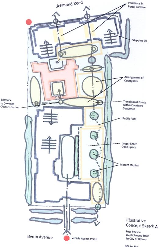
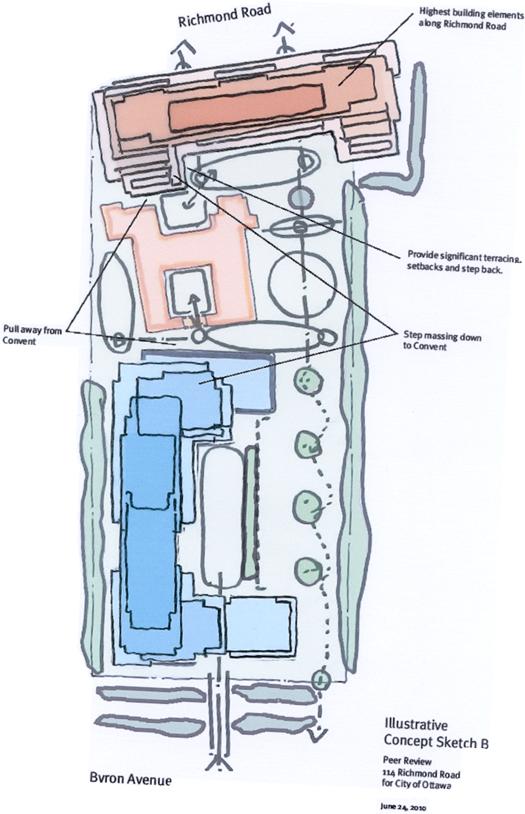
STATEMENT OF CULTURAL HERITAGE VALUE DOCUMENT 7
STATEMENT OF CULTURAL HERITAGE VALUE
Description of Property - The Soeurs de la Visitation d’Ottawa, 114 Richmond Road.
The Soeurs de la Visitation d’Ottawa Monastery is a large stone structure surrounded by vast enclosed grounds, located on Richmond Road in the Westboro neighbourhood of Ottawa.
Statement of Cultural Heritage Value or Interest
The Soeurs de la Visitation d’Ottawa Monastery consists of a convent building sited within 4 acres of carefully tended grounds, and enclosed on its perimeter by walls and mature vegetation. The building is comprised of two parts, a Gothic Revival house built in 1864-1865 and four additional wings completed in 1913 to transform the structure into a monastery. Its cultural heritage value lies in its being an excellent example of both an 1860s Gothic Revival House and an early 20th century monastery. The complex has historical value for its association with James Skead (owner 1880 until his death in 1884, whose widow lived there until 1887), a lumberman, senator, Ottawa booster and founder of Skead’s Mills and George Holland, (owner 1887-1910), a successful publisher and innovator, and with the Soeurs de la Visitation d’Ottawa. It is also a rare surviving example of a property that housed a cloistered religious community for over 100 years and functioned as a self-sustaining entity for much of that time.
The original house portion of the monastery structure was built in 1864-1865. James Dyke, a local merchant, is thought to have built the house prior to selling the property to George Eaton, a gentleman farmer. It was one of a number of properties built on larger lots laid out along Richmond Road for members of Ottawa’s emerging elite class. Features of the house associated with the Gothic Revival style include the steeply pitched gable roof, the dormer and bay windows, gables with bargeboard trim, and stone quoins and voussoirs. The picturesque gardens located at the front of the property are also a feature often associated to the Gothic Revival style.
The longest owner of the building prior to its purchase and conversion to a monastery in the early 20th century was George Holland, a prominent local newspaperman, and with his brother Andrew, a communications entrepreneur. In 1909 George and Alison Holland sold the entire property to the Soeurs de la Visitation, a cloistered order of nuns founded in Annecy, France in 1610. The order, whose members devote themselves to prayer, established monasteries across Europe in the centuries following its establishment. The Order’s founders, St. Francis de Sales and Ste. Jeanne Francois de Chantal, have both been beatified. The nuns moved into the house in 1910 and, by 1913, its conversion to a monastery was complete. It consists of four wings, arranged around a central courtyard or cloister, a plan followed by the monasteries of medieval Europe, and used for Roman Catholic convents and monasteries around the world. The features of the 1913 wings that express the building’s role as a cloistered convent include its inward-facing plan with the wings arranged around a central courtyard or cloister, the tall, two storey construction with regularly spaced rectangular windows, a high basement and an attic lit by spaced dormer windows, the chapel and its associated pointed arch windows, the steeple and the galleries and verandas.
Early on, after its acquisition by the Soeurs de la Visitation, the property was encircled by high walls and vegetation which shielded the monastery from the exterior world. The grounds demonstrate the historic use of the property by the 19th Century owners, including Skeads and Hollands, and by the Soeurs de la Visitation. They comprise, at the front, the picturesque gardens dating from the 19th Century. At the rear of the building, more domestic spaces were initially used for the purposes of communal farming, including a kitchen garden, which sustained the needs of the community. Later this evolved into a more contemplative space, which acted in part as a burial location for the Order. Like the building, the formal and domestic landscape associated with the monastery is rooted in the traditions of Western European religious architecture.
Description of Heritage Attributes
Key attributes that embody the heritage value of the Soeurs de la Visitation d’Ottawa Monastery as an excellent example of both a large Gothic Revival house and a monastery include:
House
• steeply pitched roof with narrow gable-roofed dormers
• front veranda
• bay window with wooden pointed arch details
• decorative bargeboard
• tall chimneys
• stone quoins and voussoirs
1913 Monastery addition
• tall stone walls with evenly spaced windows
• high hipped metal-clad roof with gable and triangle dormers
• bellcote
• veranda and galleries
• Chapel and its interior volume
• the plan, including central courtyard/ cloister enclosed on four sides
• the distinctive flower bed pattern in the courtyard
Grounds: • picturesque garden with its mature trees and layout of pathways and flowerbeds
• the duality of the formal landscape fronting Richmond Road, and domestic, more informal character of the grounds at the rear