Report to/Rapport au :
Planning and Environment Committee
Comité de l'urbanisme
et de l'environnement
15 June 2011 / le 15 juin 2011
Submitted by/Soumis
par : Nancy Schepers, Deputy City
Manager/
Directrice municipale adjointe,
Infrastructure Services and Community
Sustainability/Services d’infrastructure et Viabilité des collectivités
Contact
Person/Personne-ressource : Derrick Moodie, Manager/Gestionnaire,
Development
Review-Suburban Services/Examen des projets d'aménagement-Services suburbains,
Planning and Growth Management/Urbanisme et Gestion de la croissance
(613) 580-2424,
27811 Derrick.Moodie@ottawa.ca
|
SUBJECT: |
ZONING
- Part of 100 Rossignol Drive (FILE NO. D02-02-09-0050) |
|
|
|
|
OBJET : |
ZONAGE - partie du 100, promenade rossignol (dossier no. d02-02-09-0050) |
REPORT RECOMMENDATION
That the Planning Committee recommend Council refuse an amendment to the Zoning By-law 2008-250 to change the zoning of Part of 100 Rossignol Drive to a General Mixed Use Zone with exceptions to permit a mix of high density commercial and residential uses.
RECOMMANDATION
DU RAPPORT
Que le Comité de l’urbanisme
recommande au Conseil de refuser une modification au Règlement de zonage
2008-250 visant à changer la désignation de zonage d’une partie du 100, promenade Rossignol à Zone générale
d’utilisations mixtes assortie d’exceptions afin de permettre une combinaison d’utilisations résidentielles et commerciales de forte
densité.
BACKGROUND
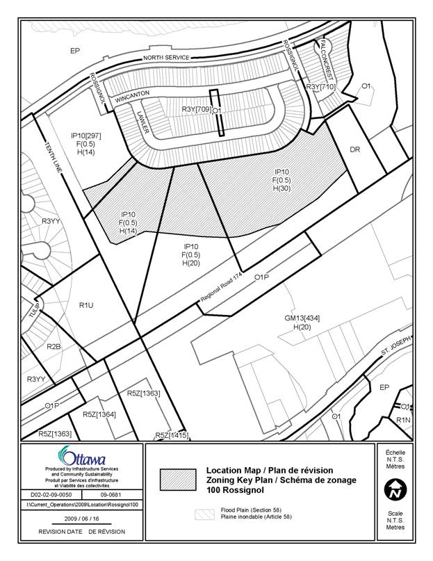
The subject lands, part of 100 Rossignol Drive, are surrounded to the north by existing residential development, the North Service Road and the Ottawa River, to the west by Tenth Line Road, to the east by residential development and Brisebois Creek and to the south by Highway 174.
The Zoning By-law Amendment proposal requested to change the zoning from a Business Park Industrial Zone (IP10 F(0.5) H(14)/H(20)/H(30)) to a General Mixed-Use Zone with exceptions to building heights and floor space index to allow a mix of high density commercial and residential uses.
The existing zoning is a Business
Park Industrial Zone IP10 F(0.5) H(14)/H(20)/H(30), which permits light
industrial uses as well as a community health and resource centre, day care, medical
facility, office and restaurant among other uses. The zoning permits a
residential care facility and retirement home only if they are
ancillary and are an integral part of a medical clinic or community health and
resource centre. There is currently a height maximum defined in three separately
identified areas which are 14 metres (six storeys), 20 metres (eight storeys)
and 30 metres (10 storeys). The
shortest height is permitted closest to Tenth Line Road whereas the tallest
buildings are permitted only in the area furthest away from Tenth Line Road abutting
Highway 174.
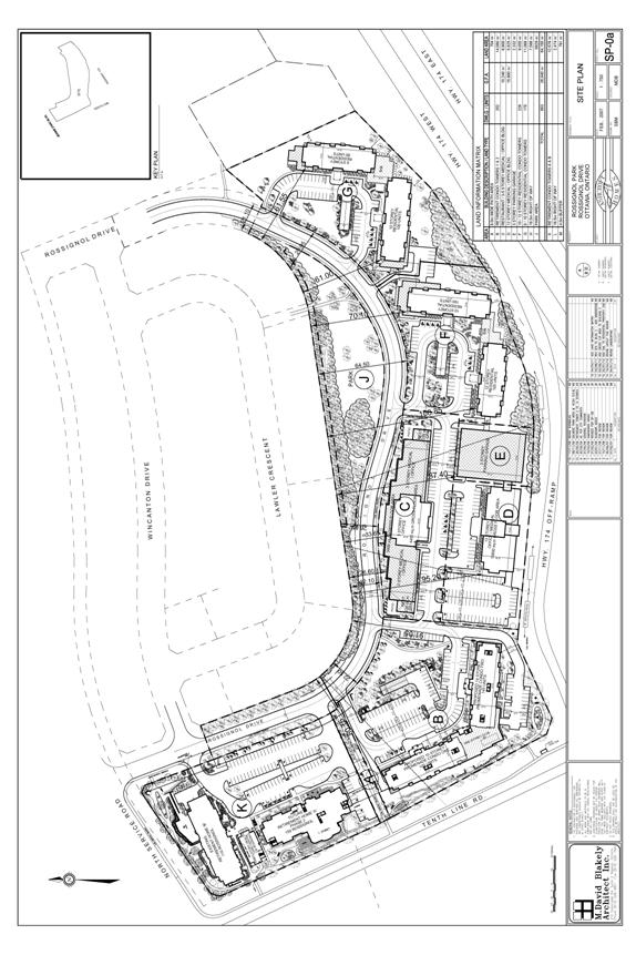
The zoning amendment proposal submitted by the applicant would permit a mixed-use development including apartment units, retirement apartment units, office space, a restaurant, a medical building and an ambulatory centre. The exceptions would be to the height and floor space index. The height adjacent to the existing residential development is proposed to be a maximum of 20 metres and abutting Highway 174 a maximum of 46 metres. The floor space index would be increased from 0.5 to 1.35.
In an attempt to create an acceptable transition from existing land uses, the proposal shows a public street, a tree buffer and a park to separate the proposed development from the existing residential neighbourhood. The buildings closest to the new public road and west of the park are shown at a height of three to five storeys. These are proposed to include medical/office uses. The tallest buildings varying between eight to 12 storeys shown abutting the Highway 174 off ramp to the south are a mix of office/medical and residential apartments. Also, two buildings of 10 and 14 storeys, intended for senior’s apartments, are being proposed at the corner where Tenth Line Road and the off ramp intersect. In response to staff comments, the buildings would be situated to ensure that the heights are graduated.
The Ontario Municipal Board (OMB) decision issued on September 1, 2006 with respect to the abutting lands at the south east corner of Tenth Line Road and North Service Road stated that on 1.45 hectares of land being developed, 160 jobs would be generated and that a job generation at a comparable rate (if not better) should be expected on the balance of the applicant’s lands. The premise for the decision was the introduction of the Ambulatory Health Care Centre in the first phase of the development. A small scale medical facility has been built to comply to the existing zoning’s requirement for a clinic with a senior’s residence as an ancillary use. The applicant has advised that to date, the six-storey senior’s residence is only partially occupied and the medical building remains vacant, which is an indication of non compliance to the OMB direction.
In light of this, the details of zoning are crucial to ensure a reasonable amount of employment is provided on the remainder of the lands currently zoned while considering the need for seniors housing. However, it is not appropriate to put any alternate in place in the absence of a plan of subdivision because the lands only have frontage on Tenth Line Road at this time.
Plan of Subdivision
In the
absence of a plan of subdivision submitted for review, the City cannot support
the proposed zoning amendment because blocks have not been created to determine
the location of the public street and the dedication of parkland required
within this community. More importantly, the proposed development currently has
only one access to a public street (Tenth Line Road) which cannot accommodate
the entire development. Furthermore, the
application review has determined that there will be no access to the proposed
development from Tenth Line Road because of the proximity to the Highway’s
off-ramp and to North Service Road, and yet that is what zoning at this stage
would oblige. An existing public street is intended to be continued in the form
of a crescent which will surround the existing residential development. This street will give the entire site
frontage along a public street, which will permit development to occur by
block. It will also allow the park to
have street frontage for full public access, will allow improved transit
service within this neighbourhood and will create pedestrian linkages
throughout the subdivision to Tenth Line Road to facilitate access to the
future transit station south of Highway 174.
DISCUSSION
The subject lands are designated
General Urban Area in the
Official Plan, policies which encourage a full range of housing types to meet
the needs of residents of all ages, incomes and life circumstances. This, combined with employment, leisure and
institutional uses will facilitate the development of complete and sustainable
communities.
The City’s Transit Oriented Development Guidelines
apply to any development located within 600 metres of a proposed transit
station or
major transit stop along the primary rapid transit network shown on Schedule D
of the Official Plan. Any proposed high-density employment and residential
development should be located close to transit stations. This proposal would be
in keeping with this policy.
Issues of compatibility are addressed in the Official Plan through the
appropriate designation of land. Locational
policies are required to direct uses that have the potential to generate
negative impacts particularly at the periphery of residential neighbourhoods. Because
land use designations such as General Urban Area, Mainstreets and Employment
Area contain broad use permissions, the Zoning By-law must establish more
specific permitted uses and development regulations on individual sites in order
to achieve compatibility among proximate uses and built forms.
At the neighbourhood scale, issues such as noise, spillover of light, accommodation
of parking and access, shadowing, and micro-climatic conditions must be carefully
considered when assessing the relationships between new and existing
development.
Arriving at compatibility of scale and use requires a specific design to
appropriately address the impact generated by infill or intensification. Any
change to the permitted use of the land and increase of the height or density
permitted may be addressed through the zoning amendment process, however, the
compatibility of the proposed development must be considered with respect to
the existing surrounding uses.
Criteria such as height, bulk or mass, scale relationship, and
building/lot relationships, such as the distance or setback from the street,
and the distance between buildings should be used to determine compatibility.
Assessing the compatibility of new development involves not only consideration
of built form, but also of operational characteristics, such as traffic,
access, and parking.
In this case, although an effort has been made to create a transition
between the existing residential neighbourhood and the proposed development,
the suggested height increase is not in keeping with the Official Plan policies
relating to compatibility within an existing community.
Rationale for why the zoning should not be approved
The zoning amendment cannot be supported in the absence of a plan of subdivision because the proposal includes an entire development which requires a public street to provide lot frontage, parkland dedication and buffer, public transit and pedestrian linkages.
Staff
requested that a plan of subdivision be submitted concurrently with the zoning
amendment very early in the process, however an application was never received.
Therefore, it is staff’s opinion that allowing a zoning amendment to go forward
without a plan of subdivision in this case is premature. The absence of a plan
of subdivision does not allow the proposed development to be evaluated in a comprehensive
manner and is not a good planning practice.
Although the City policies permit the proposed mix of uses and density in proximity to a transit station, the proposed building heights exceed the existing maximum permitted height of 30 metres (10 storeys). Despite the transition in building heights proposed, the taller buildings which exceed 10 storeys are not compatible with the surrounding uses.
The applicant’s traffic study has recommended that an eastbound right-turn lane at North Service Road and Rossignol Drive be constructed to accommodate the proposed development. OCTranspo has also identified Rossignol Drive as a future transit route.
To date, no noise report has been submitted with the zoning amendment.
At this time the applicant’s consultant has not yet demonstrated in their servicing analysis that there is sufficient capacity in the existing infrastructure to accommodate the development.
RURAL IMPLICATIONS
N/A
CONSULTATION
Notice of this application was carried out in accordance with the City's Public Notification and Consultation Policy.
The main issues which have been raised by the surrounding residents and community associations received by the City can be summarized as follows:
1) Removal of existing trees is a concern; tree preservation will minimize impact on the environment (natural habitat)
2) Loss of privacy
3) Increased traffic volumes; traffic calming measures should be introduced (i.e. raised crosswalks across Rossignol Drive)
4) Lighting on future buildings will have an impact on existing homes
5) Without trees, noise from Highway 174 will be more pronounced
6) Want the height capped at two or three storeys adjacent to residential and six storeys against Highway 174; proposed height should be reduced
7) Want tree buffer between existing residences and extension of Rossignol to shield homes from lights and noise (11- to 20-metre buffer)
8) Want entrance on Tenth Line Road to limit internal traffic on Rossignol
9) Sound barrier along Tenth Line Road should be considered
10) Want privacy fence installed behind the homes on Lawler Crescent
11) Residential uses should not be permitted; commercial/industrial land in Orleans should be maintained to allow the possibility of professional employment opportunities
12) Medical Building should not be located behind the residential homes; this will impede on the privacy of those homes
13) The park shown on the concept plan is not large enough to serve the community; an active park is needed in this neighbourhood
14) Access to the future Tenth Line transit-way stop should be provided for the public
15) Intensification should be compatible with existing neighbourhoods; proposal does not blend in with the character of the neighbourhood
16) Sun/shadow effect will have a negative effect on existing homes
17) Fear that there will be insufficient parking provided to accommodate new development; add no parking signs on Lawler Crescent and Rossignol Drive
Response to Public Comments
Staff worked with the applicant to respond to the public comments received, however the height issue was never resolved. Also, a plan of subdivision was requested but never received, making it difficult to examine this development in a comprehensive manner. Staff cannot be assured that the applicant will provide a tree buffer, a park in a centralized location and a public street further away in the absence of a plan of subdivision.
COMMENTS BY THE WARD
COUNCILLOR(S)
The Councillor believes that the zoning should remain Business Park Industrial zone for purposes of employment in the Orleans Community.
LEGAL IMPLICATIONS:
Should the recommendation be adopted and the matter appealed to the Ontario Municipal Board, it is anticipated that a three to five day hearing would result. In this scenario, it is expected that the hearing could be conducted within staff resources. In the event that a rezoning is approved, and the matter appealed to the Board, it will be necessary for the City to retain an external planner. It is estimated that the cost that would be incurred by the City would be in the range of $15,000 to $25,000. Under Council policy, where the position of a developer is substantially the same as the City, the developer would be required to reimburse the City for legal costs at the rate of $160 per hour to a maximum of $10,000.
RISK MANAGEMENT IMPLICATIONS:
N/A
FINANCIAL IMPLICATIONS
Potential costs are outlined in the Legal Implications section above. Should the services of an external planner be required, funds ($15,000 to $25,000) are not available within existing budget, and the expense may impact Planning and Growth Management’s operating budget status.
ENVIRONMENTAL IMPLICATIONS
A Tree Conservation Plan would be required with a Plan of Subdivision submission to determine which existing trees could be preserved.
TECHNOLOGY IMPLICATIONS
N/A
CITY STRATEGIC PLAN
The application is consistent with the Planning and Growth Management priority which encourages the infill and intensification of lands designated General Urban Area, however the proposed heights do not comply with City policies.
APPLICATION PROCESS TIMELINE STATUS
The application was not processed by the "On Time Decision Date" established for the processing of Zoning By-law amendments due to the absence of a plan of subdivision and the complexity of the issues associated with the proposal.
SUPPORTING DOCUMENTATION
Document 1 Location Map
Document 2 Proposed Concept Plan
DISPOSITION
City Clerk and Solicitor Department, Legislative Services to notify the owner, applicant, OttawaScene Canada Signs, 1565 Chatelain Avenue, Ottawa, ON K1Z 8B5, Ghislain Lamarche, Program Manager, Assessment, Financial Services Branch (Mail Code: 26-76) of City Council’s decision.
Planning and Growth Management to prepare the implementing by-law, forward to Legal Services and undertake the statutory notification.
Legal Services to forward the implementing by-law to City Council.
LOCATION MAP DOCUMENT
1
PROPOSED CONCEPT PLAN DOCUMENT 2