Report to/Rapport au:
Comité de l'urbanisme
and Council / et au Conseil
29 August 2011 / le 29 août 2011
Submitted by/Soumis par : Nancy
Schepers, Deputy City Manager/Directrice municipale adjointe, Infrastructure Services and
Community Sustainability/Services d’infrastructure et Viabilité des
collectivités
Contact Person/Personne-ressource : Derrick Moodie,
Acting Manager/Gestionnaire intérimaire, Development Review-Suburban
Services/Examen des projets d'aménagement-Services suburbains, Planning and
Growth Management/Urbanisme et Gestion de la croissance
(613) 580-2424, 15134
Derrick.Moodie@ottawa.ca
|
Ref N°: ACS2011-ICS-PGM-0170 |
|
|
|
|
OBJET : |
REPORT RECOMMENDATION
That the Planning Committee recommend Council approve an amendment to Zoning
By-law 2008-250 to change the zoning of 280 Herzberg Road from General
Industrial Zone Exception 1525 (IG[1525]) to Residential Fifth Density Subzone
C Exception 1866 (R5C[1866]), as shown in Document 1 and detailed in Document 4.
RECOMMANDATION DU RAPPORT
Que
le Comité de l'urbanisme
recommande au Conseil
d’approuver une modification au Règlement de zonage 2008-250 afin de faire passer le zonage du
280, chemin Herzberg de IG[1525] (Zone d’industrie générale, dotée d’une
exception 1525) à R5C[1866] (Zone résidentielle de densité 5, Sous-zone C,
dotée d’une exception 1866), comme le montre le document 1 et l’explique en
détail le document 4.
BACKGROUND
The subject property, 280 Herzberg Road, is located
on the northwest corner of Herzberg Road and Terry Fox Drive within the Kanata
North Business Park (as shown on Document 1).
The site has an area approximately 0.15 hectares in size and it currently
contains a one-storey dwelling, detached garage and small storage shed. Herzberg Road forms both eastern and southern
property lines for the subject site. The majority of the lot has been cleared
but there are mature trees along its perimeter.
Two gravel driveways have been established along Herzberg Road. The site
has approximately 32 metres of frontage on Herzberg Road. The lot is presently
on private water and sanitary facilities.
The applicant proposes to connect to full municipal services for any
future on-site development.
The Marshes Golf Course is located immediately
to the east and south of the road on the opposite side of Herzberg Road. There is a vacant parcel of land west of
Terry Fox Drive. The adjacent property
to the north has been recently developed as stacked office units.
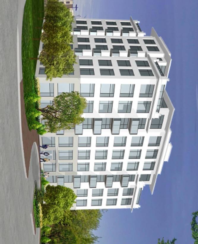
The applicant proposes to demolish the single detached dwelling unit at
280 Herzberg Road and replace it with a seven-storey residential apartment building
with 36 condominium units and 44 indoor parking spaces. The building will have
frontage on Herzberg Road and Terry Fox Drive with a footprint of approximately
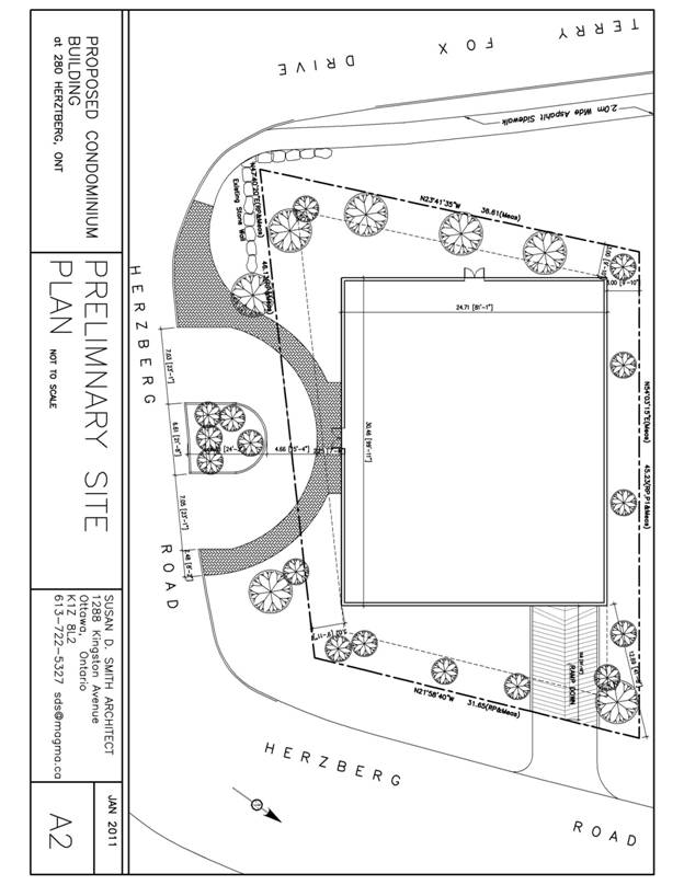
720 square metres (as shown on Document 3).
The building is proposed to be set back three metres from both Herzberg
Road and Terry Fox Drive. The ground floor will contain an amenity area. The
proposed unit breakdown will be a mix of one bedroom, one bedroom plus den, two
bedroom and two bedroom plus den units.
The vehicle entry to the underground parking is proposed to be from the
eastern side along Herzberg Road with a passenger drop-off located along the
southern Herzberg Road frontage. The drop-off will be restricted to a one-way operation
in the counter clockwise direction (as shown in Document 2).
The applicant is proposing a total of 44 parking spaces (1.0 space per
dwelling unit with 0.2 provided for visitor parking) on site located in two
underground parking levels. This includes visitor accessible parking space.
Bicycle stalls will be provided outside at the required rate of 0.5 per unit.
Purpose of Zoning Amendment
The current residential use of the property is not permitted but exists
as a legal non-conforming use. The zoning
by-law amendment proposes to rezone the subject lands to establish a
residential zone that permits a variety of residential uses including multiple-attached
dwelling, stacked townhouse dwelling, low-rise apartment, and planned unit
development.
Existing Zoning
The subject property is currently zoned General Industrial Zone
Exception 1525 (IG [1525]). The purpose of this zone is to permit a wide range
of low-to-moderate impact light industrial uses in accordance with the Enterprise
Area designation of the Official Plan. The
current residential use is legal non-conforming.
Urban Exception 1525, allows for the additional use of a Place of
Assembly but prohibits: animal care establishment; automobile dealership;
automobile rental establishment; automobile service station; car wash;
convenience store; gas bar; instructional facility; personal service business;
and/or restaurant.
Proposed Zoning
The applicant is proposing to amend the current zoning to a Residential
Fifth Density Subzone C Exception 1866 (R5C[1866]) with
a site specific exception to permit a reduction in the minimum required parking
from 1.2 spaces per unit to 1.0 spaces per unit.
DISCUSSION
Planning Act and Provincial Policy Statement
Section 2 of the Planning Act outlines those land use matters that are
of provincial interest, to which all City planning decisions shall have
regard. The provincial interests that
apply to this site include the appropriate location of growth and development
and the promotion of development that is designed to be sustainable to support
public transit and to be oriented to pedestrians. In addition, the Planning Act requires that
all City planning decisions be consistent with the Provincial Policy Statement
(PPS), a document that provides further policies on matters of provincial
interest related to land use development. PPS policies indicate that there
should be an appropriate mix of uses and range of housing types and densities
which efficiently use land, resources, infrastructure and public service
facilities, and support the use of alternative transportation modes and public
transit.
The proposed zoning allows for a mix of residential uses, which will
efficiently use land and contribute to a balanced community. The site is
conveniently located nearby residential and commercial areas to allow for
access by pedestrians. The density of
the proposal makes good use of existing urban lands, services, and
infrastructure. Staff
conclude that the proposal is consistent with the matters of provincial
interest as outlined in the Planning Act and PPS.
Official Plan
Strategic Direction
Section 2 of the Official Plan sets broad strategic directions to meet
the challenge of managing growth, providing infrastructure, maintaining
environmental integrity and creating liveable communities within Ottawa. To
meet these challenges, polices are set out to pursue a mix of land uses,
housing types and compact forms of development which in turn will enable the
City to support a high-quality transit system and make better use of existing
infrastructure and roads. The proposed
development provides a density that will support this overall goal.
Land Use Designation
The site is designated as “Enterprise Area” on Schedule B of the
Official Plan with Agricultural Resource Area and Greenbelt Rural Designations located
on the opposite side of Herzberg Road.
Enterprise Areas are areas of employment that may accommodate the
integration of housing without detracting from its ability to accommodate jobs.
The designation must still provide opportunity for a concentration of
employment but, by increasing the employment densities, may also be able to
support medium and high-density housing.
Under Section 3.6.5 of the Official Plan, Enterprise Areas have the
following characteristics:
·
The
potential to provide for at least 2,000 jobs;
·
At least
50 percent of the land is or will be devoted to employment;
·
The
employment uses existing or planned for the area will not negatively impact on
residential uses through noise, odour, health concerns or other conflicts;
·
Generally,
the employment uses have less stringent location requirements than those
associated with Employment Areas, except that the area should be well served by
public transit and may require access to truck routes;
·
Contain
business park type employment such as offices, but have the potential to
achieve employment densities higher than achieved in traditional park-like
settings; and
·
Are
easily accessible from the surrounding community so that residential uses can
be well integrated, both within the Enterprise Area itself and with the
adjoining residential area, and can easily access residential amenities and
services.
Policy 4 of Section 3.6.5 states that residential uses are permitted in
Enterprise Areas by amendment to the zoning by-law. Applications to provide for
residential uses within an Enterprise Area will be considered provided the
following criteria are met:
a)
The
applicable site development policies in the Official Plan have been satisfied;
b)
A mix of
housing is provided, but all housing is in the form of townhouses, stacked
townhouses or apartments;
c)
The
Enterprise Area and particularly the residential uses within it, is linked to
adjacent areas by roads and pathways;
d)
The
residential uses are functionally integrated with employment uses through such
means as sharing sites or buildings occupied by employment uses, occupying
sites adjacent to employment uses, provision of common linkages (roads,
pathways), strategic location of parks so as to be mutually beneficial, central
location of employment uses, opportunities to share parking, convenient transit
routing, mutual accessibility to convenience uses, amenities and services, and
any other means that may be appropriate; and
e)
Any
demand that residential uses will create for additional amenities and services
has been assessed and the means of addressing such demands has been identified.
After a thorough review of the policies listed above, staff conclude that the subject site meets all of the
criteria to permit a residential use in the Enterprise Area. Furthermore, the type of development that is
proposed meets the densities and design criteria promoted in the City’s design
guidelines.
Compatibility and Urban Design
Section 2.5.1 of the Official Plan establishes design objectives which
describe the vision for the form of the City’s built environment. These objectives are broadly stated and are
applicable to all land use designations either at the city-wide level or on a
site-specific basis. Design principles
are further set out to describe how the City intends to achieve the design
objectives, with acknowledgment that all the design objectives may not be
achieved or be achievable in all cases.
The proposed development is consistent with and implements the design
objectives which speak to enhancing the sense of community, defining public and
private spaces through development, and having new development respect the
character of existing areas. An enhanced
sense of community is being achieved by infilling an underdeveloped site and
strengthening the urban fabric of the street physically and practically. Public and private spaces are being defined
through the establishment of a strong street edge and pedestrian environment.
The proposed new development respects the character of the existing area by
complementing the massing pattern, height, and character of the surrounding
context.
The subject site is well suited to supporting higher density residential
development. The surrounding area contains a predominance of employment uses
and the Enterprise Area designation supports apartments. The close proximity of
employment areas offers ideal integration opportunities based on common
linkages (roads and pathways). Additionally, the road network can easily
accommodate a minor increase in traffic with public transit servicing the site
along Terry Fox Drive for peak hour service to and from the downtown core
(Routes 169 and 182).
Details of Proposed Zoning
The Zoning By-law Amendment proposes to amend the existing General
Industrial Zone Exception 1525 (IG [1525]) to Residential Fifth Density Subzone
C Exception 1866 (R5C [1866]) zone, which would permit the proposed residential
use and a reduction in the required parking. The details of the zoning
amendment are contained in Document 2.
Parking Requirements
A total of 44 parking spaces including visitor spaces will be provided
on two underground parking levels based on the proposed rate of 1.0 space per
dwelling unit with 0.2 spaces provided for visitor parking. The Zoning By-law
requires 1.2 parking spaces per dwelling unit for an apartment building, mid–high
rise and low rise, with a complementary 0.2 spaces per dwelling unit, for
visitor parking in suburban areas, in this case for a total of 50 spaces. However, Section 101.6 of the by-law permits a
reduction of 10 percent in the minimum parking requirement, where all spaces
are provided underground. The proposed
development would qualify for a reduction of 5.0 spaces, bringing the total
required to 45 spaces. Therefore, a
reduction of 1.0 space is being requested.
Staff recommend the reduction in parking (1 space) on the
following basis:
·
The
existence of alternative modal transportation choices such as cycling, walking
and transit service from OC Transpo routes 169 and 182 directly adjacent to the
proposed development site;
·
The
majority of the anticipated building residents are likely to be individuals
employed within the Kanata North Business Park, which is easily within walking
distance to the north and south;
·
The potential for short term parking to be provided in the
proposed lay-by area, which will be explored during Site Plan approval.
In summary, 44 spaces are proposed where 45 spaces are currently
required, for a difference of one space.
Heritage Considerations
The proposed development is not beside nor does it face any heritage
properties and therefore does not impact or overwhelm adjacent heritage
character. Its proximity to the completely altered landscapes of the recently
constructed golf course and office developments also mean that there is little
impact to the heritage landscape of the greenbelt.
Infrastructure Considerations
The proponent of the Zoning Amendment Bylaw application has
demonstrated to staff, through a Site Service Briefing letter/report and
Assessment of Sanitary Flow letter/report, that public infrastructure is
available and has sufficient available capacity to service the proposed
development.
·
Sanitary
service: the proponent shall be required to extend the existing 250mm diameter
PVC sanitary sewer (approximately 40m) at their expense along Terry Fox Drive
in order to connect to proposed sanitary sewer service.
·
Storm
service: the proponent is proposing to connect to existing 450mm diameter PVC
storm sewer located along Herzberg Road via a proposed storm sewer service.
·
Water
service: the proponent is proposing to connect to existing 406mm diameter PVC watermain along Terry Fox Drive via proposed water service.
·
Site grading
and stormwater management: the site is to be designed such that, flows
to the storm sewer in excess of the 5-year storm release rate, must be detained
on site.
Conclusion
The proposed development supports the direction of the Planning Act
and Provincial Policy Statement by creating new development at densities and
locations that efficiently uses land, existing infrastructure and supports
alternative transportation. It
represents an appropriate form of intensification, and is in conformity with
the policies in the Official Plan. Staff
are satisfied that suitability, compatibility, design, transportation, and
heritage aspects of the proposed use and site have been adequately considered
in light of the relevant Official Plan policies, heritage and design
guidelines. The proposed Zoning By-law Amendment
conforms with the general intent of the Official Plan
and is compatible with the surrounding existing residential and employment uses,
and as such, staff recommend its approval.
ENVIRONMENTAL IMPLICATIONS
The Communications Research Centre (CRC), located within the Greenbelt,
at 3701 Carling Avenue, is the Federal Government's leading centre of expertise
in satellite communications. The CRC
site contains a large satellite antenna field that emits radiofrequency
electromagnetic fields. Exposure to
radiofrequency electromagnetic fields represents a possible hazard to human
health.
Radiation Protection Bureau of Health Canada has produced Safety Code 6
– “Limits of Human Exposure to Radiofrequency Electromagnetic Fields in the
Frequency Range from 3kHz to 300 GHz” to specify maximum levels and durations
of exposure to radiofrequency fields of frequencies between 3 kHz and 300 GHz
to prevent human health effects.
As part of OPA 76, a 500m buffer was added to Schedule K which limits
the height of buildings within the area affected by the Safety Code 6 to avoid
the possibility of impacts of radiofrequency electromagnetic fields originating
from the CRC antenna and to prevent new structures from blocking or adding
possible sources of radiofrequency interference at the CRC site.
The subject site is outside the 500m radius, and therefore, the height
restriction does not apply to this proposal.
CONSULTATION
Notice of this application was carried out in
accordance with the City's Public Notification and Consultation Policy. A summary of comments received is detailed in
Document 5.
COMMENTS BY THE WARD COUNCILLOR(S)
The Councillor is
aware of the application and has given her concurrence to proceed with the
zoning by-law amendment at this time.
LEGAL/RISK MANAGEMENT IMPLICATIONS
There are no legal/risk management
implications associated with this report.
CITY STRATEGIC PLAN
The application is consistent with the Planning and Growth Management
priority which encourages the infill and intensification of lands designated
General Urban Area.
FINANCIAL IMPLICATIONS
There are
no direct financial implications associated with this report.
APPLICATION PROCESS TIMELINE STATUS
The application was not processed by the "On
Time Decision Date" established for the processing of Zoning By-law
amendments due to the complexity of the issues associated with residential
development in proximity with Communications Research Centres' satellite
operations and communications.
SUPPORTING
DOCUMENTATION
Document 1 Location Map
Document 2 Proposed Site Plan
Document 3 3D Rendering
Document 4 Details of
Recommended Zoning
Document 5 Consultation Details
DISPOSITION
City Clerk and Solicitor Department, Legislative Services to notify the
owner, applicant, OttawaScene.com, 174 Colonnade Road,
Unit #33, Ottawa, ON K2E 7J5, Ghislain Lamarche, Program Manager,
Assessment, Financial Services Branch (Mail Code: 26-76) of City Council’s decision.
Planning and Growth Management to prepare the implementing by-law,
forward to Legal Services and undertake the statutory notification. Legal Services to forward
the implementing by-law to City Council.
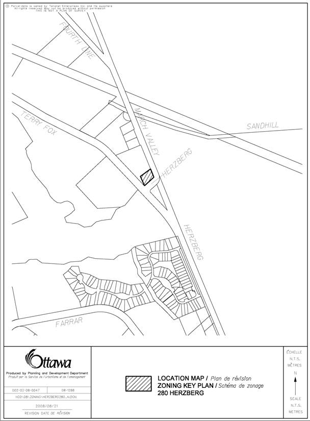 LOCATION MAP DOCUMENT
1
LOCATION MAP DOCUMENT
1
PROPOSED SITE PLAN DOCUMENT
2
3D RENDERING DOCUMENT 3
DETAILS OF RECOMMENDED ZONING DOCUMENT 4
1. The
lands known as 280 Herzberg Road will be rezoned from IG [1525] (General
Industrial Zone, Exception 1525) to R5C[1866] H25
(Residential Fifth Density Subzone C, Exception 1866, Maximum building height
of 25 metres)
2. A new exception, [1866], will be added
to Section 239 and will include the following provisions:
·
Minimum rear yard
setback shall be 3.0 metres;
·
Minimum interior
side yard setback for any part of a building located further than 21 m from the
front lot line: 3.0 metres;
·
Minimum parking
spaces required shall be 1.0 spaces per dwelling unit;
CONSULTATION DETAILS DOCUMENT
5
NOTIFICATION AND CONSULTATION PROCESS
Notification and public consultation was
undertaken in accordance with the Public Notification and Public Consultation
Policy approved by City Council for Zoning By-law amendments.
PUBLIC COMMENTS
1.
One
letter of support was received from a resident of Marshes Village, a
condominium community situated within the Kanata North Business Park. It was their opinion that any attempts to add residents to the business park in a medium density
development is a great opportunity for the area. They are concerned however with possible
impacts on the intersection of Carling and Herzberg which may be beyond
capacity.
2.
Another
resident argued against approval of this proposal. They state that the proposed development
would block their view of the golf course that they paid a premium to see. Also, they believe there would be parking
issues and trees would have to be cut down.
3.
Communications
Research Centre (CRC) required that serious investigation be undertaken prior
to Council’s decision on this proposal.
This is because of the transmission of microwave radiation emitting from
various earth stations on the CRC campus.
An additional consideration would be the line of site to the
satellites. A structure that is too tall
would interfere with satellite communication.
CRC recommends:
a) limiting construction within a 500 metre radius of
the CRC building 46 to non-residential buildings only, and limiting the height
to 10 metres.
b) At a 500 metre radius, the maximum height
could be increased to 30 metres, and further increased by 5 metres for every
100 metres further away from the compound.
These points would ensure that Safety Code 6
requirements (the Government of Canada’s Radio Frequency exposure limits) can
be met and that satellite blockage is acceptable.
RESPONSE TO
PUBLIC INPUT
·
The City
will be modifying the intersection of Carling Avenue and Herzberg Road
(scheduled for 2009) by constructing eastbound and westbound left turn lanes on
Carling Avenue and lengthening the westbound right turn lane. These modifications will improve the general
operation of this intersection.
·
Three
main points were raised:
i.
the
impact on their view:
·
At the closest point, the subject lands are
approximately 210 metres away from Marshes Village. Between the condominium and the proposed
building are 2 holes of the Marshes Golf Course. The building will not be blocking the view.
ii.
parking:
·
A total of 44 parking spaces (1 space per
dwelling unit with 0.2 provided for visitor parking) will be provided on site
on two underground parking levels; including visitor parking.
iii.
tree
cutting:
·
As part of the subsequent Site Plan Control
application, the Owner will be obliged to submit for the City’s review and
approval, a Tree Preservation and Protection Plan. He will also be required to implement the
Plan’s recommendations that will result in appropriate land stewardship.
·
Subsequent
to the submission of their initial comments, CRC undertook a detailed
investigation on the potential impact of microwave radiation on this site. They also assessed the extent of the
interruption of satellite communication that will occur as a result of the
construction of a tall building. In
addition to these examinations, extensive communication between CRC, the Owner
and City staff has taken place to consider this proposal. Through these efforts, it has been determined
that residential development at 280 Herzberg Road may proceed provided that it
is situated beyond 500 metres from CRC’s satellite transmission source
(identified as Building 46) and the height of the building remains below 25
metres. The Owner has accepted these
restrictions and will design his building accordingly.