Report to/Rapport au :
Comité de l'urbanisme
and Council / et au Conseil
19 August 2011 / le 19 août 2011
Submitted by/Soumis par : Nancy
Schepers, Deputy City Manager/Directrice municipale adjointe, Infrastructure Services and
Community Sustainability/Services d’infrastructure et Viabilité des
collectivités
Contact Person/Personne-ressource :
Richard Kilstrom, Acting Manager/Gestionnaire intérimaire, Development
Review-Urban Services, Inner Core/Examen des projets d'aménagement-Services
urbains, Unité du Centre intérieur
Planning and Growth
Management/Urbanisme et Gestion de la croissance
(613) 580-2424, 22379
Richard.Kilstrom@ottawa.ca
|
|
Somerset
(Ward 14) Ref
N°: ACS2011-ICS-PGM-0174
|
SUBJECT: |
ZONING – 409 to 411 Preston Street (FILE NO. D02-02-11-0003) |
|
|
|
|
OBJET : |
REPORT RECOMMENDATION
That the Planning Committee recommend Council approve an amendment to
the Zoning By-law 2008-250 to change the zoning of 409 and 411 Preston Street
from TM[86] to TM[XXXX], as detailed in Document 2.
RECOMMANDATIONS DU RAPPORT
Que le Comité
de l’urbanisme recommande au Conseil d’approuver une modification au Règlement
de zonage 2008-250 afin de changer la désignation de zonage des 409 à 411 de la
rue Preston de TM[86] à TM[XXXX], comme il est expliqué en détail dans le
Document 2.
BACKGROUND
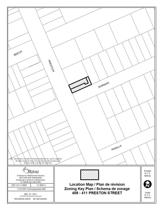
The subject site, 409 and 411 Preston Street,
is a corner property at the northeast intersection of Preston Street and Norman
Street. The site has a combined frontage of approximately 11 metres (m), a lot
depth of 27.45m and a total site area of approximately 300m2.
The two properties are occupied by a two-and-a-half storey semi-detached
dwelling fronting onto Preston Street and a detached garage located at the rear
of the lot. The garage and three surface parking spaces located in front of the
garage are accessed from Norman Street. A raised paving stone walkway provides
access from the parking at the rear of the property to the front doors of the
semi-detached building.
As part of the redevelopment of this property, the existing
semi-detached dwelling will remain while an existing frame vestibule at the
rear of the dwelling along with the detached garage will be demolished and in
its place, a three-story, three unit condominium building accessed from Norman
Street.
The site immediately to the north of the subject property is occupied by
a two-storey commercial/industrial building with a recessed loading area
accessed off of Preston Street. The
remainder of the block to the north has been developed with a one-to two-storey
building that turns the corner onto Beech Street and is occupied by a
restaurant. The area along Preston Street to the north, beyond Beech Street, is
characterized by low and medium profile mixed-use buildings containing other
retail, restaurant, commercial and office uses.
The area to the west of the property, across Preston Street, is occupied
by a two-storey mixed use building containing restaurant and office uses. The
area behind the mixed-use building, west of Preston Street, is predominantly
low-profile residential development with some limited industrial uses located
mid block.
The south side of Preston Street, immediately opposite the site, is
occupied by a two-storey Bank of Nova Scotia building and associated parking
lot located at the rear. The property immediately abutting to the east is
occupied by a two-and-a-half-storey single detached home. Continuing east, the
area is characterized by an established residential neighbourhood consisting of
low-profile single detached dwellings.
The property is within walking distance to a number of employment nodes.
The Booth Street government complex is located east of the property at the end
of Norman Street while another extensive office complex is located two blocks
north of the site near the Queensway.
The site is located within 600m of Carling Station on the O-Train
Transit Line providing easy access to downtown. In addition, Carling Avenue has
been identified as a Future Rapid Transit Corridor while Preston Street has
been designated as an on-road cycling route.
Purpose of Zoning Amendment
The purpose of the Zoning By-law amendment application is to change the
zoning on the site to permit a three-unit dwelling, defined in the Zoning
By-law as a “residential use building originally constructed to contain three
principal dwelling units divided horizontally”, where the current zoning does
not permit this type of development. The
applicant is also requesting a number of reliefs to the zone provisions
including, but not limited to, reduction in yard setbacks and parking
requirements (see Document 2).
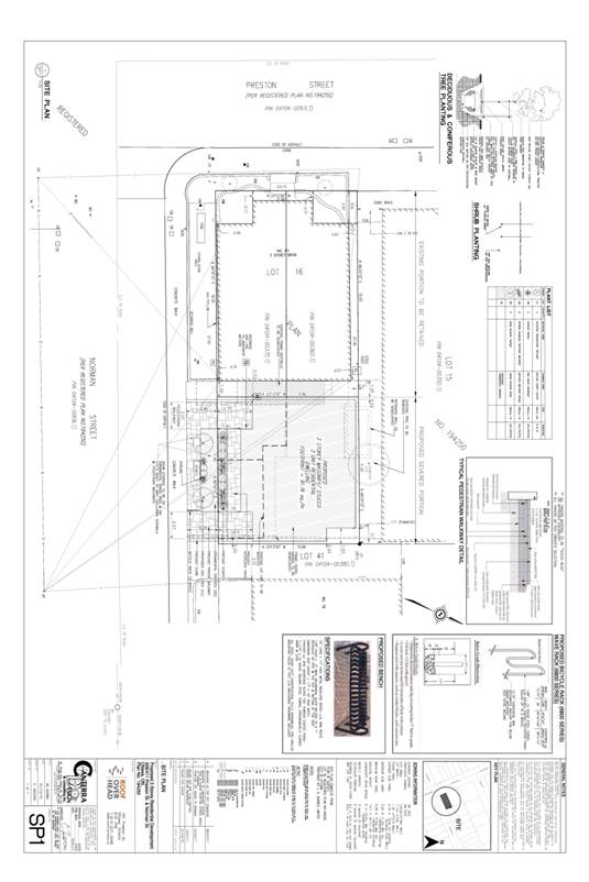
The property will be subdivided creating a new parcel of land to
accommodate the proposed development, subject to Committee of Adjustment
approval. The proposed lot will have an area of approximately 125 square metres
with a lot frontage of approximately 11.43m along Norman Street and a lot depth
of approximately 10.9m.
Existing Zoning
The property is currently zoned Traditional
Mainstreet Special Exception 86 (TM [86]). The purpose of the
Traditional Mainstreet zone is to accommodate a broad range of uses including
retail, service commercial, office, residential and institutional uses as well
as mixed-use buildings.
Urban exception 86 states that lots 603m2 in area or greater
must be developed as mixed-use with the gross floor area dedicated to
commercial uses not exceeding the gross floor area dedicated to residential
uses. Further, a place of assembly, instructional facility and recreational and
athletic facility are limited to areas above grade. The Exception also includes a definition for
restaurant.
Proposed Zoning
The proposed zoning will make the following changes to the TM[86] zone (See Document 2 for details) on this site:
·
Add three-unit dwelling as a permitted
use;
·
Subsection
197(1)(c) does not apply;
·
Minimum front
yard setback is 0.75m;
·
Minimum
corner side yard setback is 0.09m;
·
Minimum
interior side yard setback is 0.20m;
·
Minimum rear
yard is 0.20m;
·
No minimum
required landscape area abutting a residential zone;
·
No parking is
required; and
·
Despite Section 65-Table 65 6(b) –
balconies higher than 0.6 m above adjacent grade may project up to 0.2m from
any lot line.
DISCUSSION
Planning
Act and Provincial Policy
Statement
Section 2 of the Planning Act outlines
those land use matters that are of provincial interest, to which all City
planning decisions shall have regard.
The provincial interests that apply to this site include the appropriate
location of growth and development and the promotion of development that is
designed to be sustainable to support public transit and to be oriented to
pedestrians. In addition, the Planning
Act requires that all City planning decisions be consistent with the
Provincial Policy Statement (PPS), a document that provides further policies on
matters of provincial interest related to land use development. PPS policies
indicate that there should be an
appropriate mix of uses and range of housing types and densities which
efficiently use land, resources, infrastructure and public service facilities,
and support the use of alternative transportation modes and public
transit.
The proposed zoning allows for an
increased mix of residential and commercial uses in the area, which will
efficiently use land and contribute to a balanced community. The site
is located on an arterial road and transit priority corridor (Preston Street), which provides excellent access to the
site and is a focus for a mixed-use development. The site is conveniently located near
residential and commercial areas to allow for access by pedestrians. The density of the proposal makes good use of
existing urban lands, services, and infrastructure. Staff conclude that the
proposal is consistent with the matters of provincial interest as outlined in
the Planning Act and PPS.
Official Plan
Strategic Directions
Section 2 of the Official Plan
sets broad strategic directions to meet the challenge of managing growth,
providing infrastructure, maintaining environmental integrity and creating
liveable communities within Ottawa. To meet these challenges, polices are set
out to pursue a mix of land uses, housing types and compact forms of
development which in turn will enable the City to support a high-quality
transit system and make better use of existing infrastructure and roads. The proposed development provides a mix of
uses and housing types at densities that will support this overall goal.
Land Use Designation
The site is designated as
“Traditional Mainstreet” on Schedule B of the Official Plan. Traditional Mainstreets exhibit compact urban
character with a pedestrian-oriented pattern of development and mix of uses
that provide for access by a variety of transportation modes. Mainstreets are intended to function as
mixed-use corridors in order to sustain the surrounding community and the
transit system, and to provide a focus for the community. They are intended to establish a strong street
edge with buildings that are human-scaled.
This designation recognizes the importance of the site to achieving a
positive pedestrian environment, and as a location for additional density.
The proposed development achieves a more intense, yet human-scaled
built form within a mix of uses in this part of Little Italy and will
contribute to supporting the public transit system and community services, and
therefore is in conformity with the Traditional Mainstreet policies.
Compatibility and Urban Design
Section 2.5.1 establishes design objectives which describe the vision
for the form of the City’s built environment.
These objectives are broadly stated and are applicable to all land use
designations either at the city-wide level or on a site-specific basis. Design principles are further set out to
describe how the City intends to achieve the design objectives, with
acknowledgment that all the design objectives may not be achieved or be
achievable in all cases.
The proposed development is consistent with and implements the design
objectives which speak to enhancing the sense of community, defining public and
private spaces through development, and having new development respect the
character of existing areas. An enhanced
sense of community is being achieved by infilling a site that presently has
garages and a parking area and strengthening the urban fabric of the street
physically and practically. Public and
private spaces are being further defined through the establishment of a strong
street edge and pedestrian environment. The proposed new development respects
the character of the existing area by complementing the massing pattern,
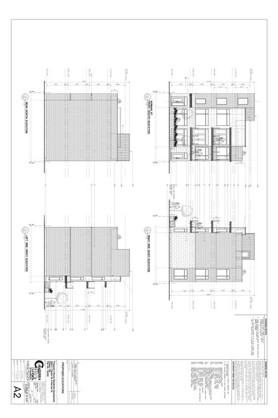
height, and character of the surrounding context (see Documents 3 and 4 for the
proposed site plan and building elevations).
Section
4.11 as well as the Urban Design Guidelines provide further
direction on design and compatible development.
The proposal was also reviewed in light of the Urban Design Guidelines
for Traditional Mainstreets and Transit-Oriented Development. The
following is an analysis of the applicable criteria, which demonstrates that
the proposed development satisfies the compatibility tests of the Official Plan
in a way that does not result in undue adverse impacts:
Building Height and
Massing:
·
The planned function for this area is
Traditional Mainstreet which allows for a building height in the range of four
to six storeys, with a minimum height requirement of two
storeys. At three-and-a-half storeys, the proposed
development is less than what is typically permitted but achieves the minimum
planned building height for Mainstreets.
·
The building typology, although not
identical, is comparable and compatible with the existing neighbourhood. The
development is considered low profile and is in keeping with the low profile
character of the neighbourhood. Building heights along Norman Street are not
consistent, ranging from two-and-a-half-storeys to
one-and-a-half-storeys.
·
At three and a half-storeys, the development transitions well from the
two-and-a-half-storey detached dwelling to the east and the two-storey semi to
the west.
·
The design includes the use of different
materials at grade from those used on the upper floors. This variation in
building materials reduces the overall mass of the building by breaking it up
visually and creating human scale at grade.
·
The residential area to the east of the
site is designated Mixed-Use Centre. The planned function for Mixed-Use Centres is a denser and more compact form of development.
Pattern of the
Surrounding Community:
·
A corner property, the site is located
at the edge of a mature and established residential community. The proposed
development will book-end the street with a form of development that may be
slightly denser than what currently exists in the neighbourhood but is
comparable both in terms of scale and size and is carefully sited on the lot.
·
The proposed development has been set
back from the front lot line to follow a similar street setback and landscape
treatment at grade as existing development.
·
A front porch feature has been
incorporated at grade which is consistent with the existing residential
neighbourhood.
·
The proposed development and the
adjacent property to the east are separated by an existing driveway for the
adjacent dwelling creating a similar rhythm of spacing as exists on the remainder
of the street.
Preston-Champagne Secondary Plan
The site is located within the Preston-Champagne Secondary Plan area
and designated Main Street Corridor.
The vision for Preston Street as described in the Secondary Plan is for a
unique pedestrian-oriented community focused street providing street level
retail, ethnic restaurants, cultural facilities and residential uses.
Section 6.4 for the Main Street Corridor (Preston Street) permits
mixed-use buildings and encourages residential or other appropriate uses above
the street level. The policies require low to medium profile, human scale
mixed-use buildings in keeping with the Main Street theme as outlined in the
City’s Official Plan.
Policy 3.6.3.3, permits a broad range of uses
on Traditional Mainstreets including retail, service commercial uses, offices,
residential and institutional uses. Further, policy 3.6.3.3 states that “uses
can be mixed in individual buildings or occur side by side in separate
buildings”.
Details of Proposed Zoning
The Zoning By-law Amendment proposes to amend the existing Traditional
Mainstreet Zone Exception 86 (TM [86]) to Traditional Mainstreet Exception XXXX
(TM [XXXX]) zone, which would permit the proposed three-unit residential use, a
reduction in the required parking and modifications (reductions) to the yard
provisions. The details of the zoning amendment are contained in Document 2.
Traffic Issues
The proposed
development consists of three residential units and is not considered a
significant traffic generator. As such, a traffic study was not required by the
City in support of this proposal.
The site is adjacent
to an existing arterial roadway (Preston Street) and in proximity to a well
developed roadway network which includes other arterial and major collector roads
(Carling Avenue to the south, access to the Queensway to the North, Rochester
and Booth Street).
This proposal seeks to eliminate all of the required parking for both
the proposed development and the existing semi-detached dwelling. As a result,
no vehicular access and egress is being provided that could negatively impact
on adjacent properties.
The existing and proposed number of units collectively
generates the need for 4 vehicular parking spaces. The request to eliminate the
requirement for vehicular parking is not anticipated to create significant
spill-over parking on adjacent areas.
The site is located within 600m of a rapid transit
station; it is in walking distance to employment as well as to many other
amenities available along Preston Street. The reduction in vehicular parking
will promote increased walking, cycling and transit. On-street parking is
available along Norman Street as well as Preston Street.
Servicing Issues
The existing infrastructure in the area has adequate capacity to support
the proposed development.
Concurrent Application
A Site Plan Control
application is being processed concurrently.
CONCLUSION
The proposed development supports the direction of the Planning Act
and Provincial Policy Statement by creating new development at densities and
locations that efficiently uses land, existing infrastructure and supports
alternative transportation. It
represents an appropriate form of intensification, and is in conformity with
the policies in the Official Plan. The
Official Plan seeks to reduce the number of surface parking lots in the inner
area through redevelopment, and this proposal satisfies that goal. Staff are satisfied
that compatibility, design, and transportation aspects of the site have been
adequately considered in light of the relevant Official Plan policies and
design guidelines. The proposed Zoning
By-law amendment conforms with the general intent of
the Official Plan and existing zoning in the area, and as such, staff recommend
approval of the proposed zoning.
CONSULTATION
Notice of this
application was carried out in accordance with the City's Public Notification
and Consultation Policy (see Document 5).
COMMENTS BY THE WARD COUNCILLOR
The Councillor is aware of the application and recommendation.
LEGAL IMPLICATIONS
There are no legal implications associated
with this report.
FINANCIAL IMPLICATIONS
There are no direct financial implications associated
with this report.
ENVIRONMENTAL IMPLICATIONS
The site has been identified on Schedule M of the Secondary Plan as
Potentially Contaminated Site- Group III Site (Low Priority). The Secondary
Plan policies state that potentially contaminated sites will be subject to the
policies of the Official Plan, Section 4.8.4 Contaminated Sites.
The Contaminated Sites policies require that a Phase I Environmental
Site Assessment (ESA) documenting previous uses of the property and providing
an assessment of the actual and potential soil or groundwater contamination on
the site be submitted. A Phase I ESA in support of this application which
details the previous uses on the site and provides an analysis of potential
contamination, was completed for the site and based on the findings of the
Phase I ESA, a Phase II ESA was not recommended.
CITY STRATEGIC PLAN
The application is consistent with the Planning and Growth Management
priority which encourages the infill and intensification of lands designated
General Urban Area.
APPLICATION PROCESS TIMELINE STATUS
The application was not processed by the "On Time Decision
Date" established for the processing of Zoning By-law amendments due to the
complexity of engineering issues.
SUPPORTING DOCUMENTATION
Document 1 Location Map
Document 2 Details of
Recommended Zoning
Document 3 Proposed Site Plan
Document 4 Proposed Elevations
Document 5 Consultation Details
DISPOSITION
City Clerk and Solicitor Department, Legislative Services to notify the
owner, applicant, OttawaScene Canada Signs, 1565 Chatelain
Avenue, Ottawa, ON K1Z 8B5, Ghislain Lamarche, Program Manager,
Assessment, Financial Services Branch (Mail Code: 26-76) of City Council’s decision.
Planning and Growth Management to prepare the implementing by-law, forward
to Legal Services and undertake the statutory notification.
Legal Services to forward the implementing
by-law to City Council.
LOCATION
MAP DOCUMENT 1
DETAILS OF RECOMMENDED ZONING DOCUMENT 2
Proposed Changes to the Comprehensive Zoning By-law
- Rezone the property as shown on Document 1 from TM[86] to TM[XXXX].
- Add an exception to Section 239, for the property
including the following:
- In Column II, the text TM[XXXX]; and,
- In Column III, the text:
Further Permitted Uses
·
Three unit
dwelling
·
Hotel
·
Place of Assembly
- In Column V; the text:
·
lots
603 m2 in area or greater must be developed as a mixed use, where
the gross floor area dedicated to commercial uses must not exceed the gross
floor area dedicated to residential use
·
the
following uses are limited to locations above the ground floor: place of
assembly, instructional facility, recreational and athletic facility
·
despite Section 54,
restaurant, full-service means a restaurant that sells, serves and prepares
on-site food and beverages to patrons seated at tables, for consumption on the
premises.
·
Subsection 197(1)(c) does not apply
·
minimum front yard setback is 0.75m
·
minimum corner side yard setback is 0.09m
·
minimum interior side yard setback is 0.20m
·
minimum rear yard is 0.20m
·
no minimum required landscape area abutting a
residential zone
·
no parking is required
·
Despite
Section 65-Table 65 6(b) – balconies higher than 0.6 m above adjacent grade may
project up to 0.2m from any lot line.
PROPOSED SITE/LANDSCAPE PLAN DOCUMENT 3
PROPOSED ELEVATIONS DOCUMENT 4
CONSULTATION
DETAILS DOCUMENT 5
NOTIFICATION AND CONSULTATION PROCESS
Notification and public consultation was undertaken in
accordance with the Public Notification and Public Consultation Policy approved
by City Council for Zoning By-law amendments.
PUBLIC COMMENTS
In
regards to the zoning bylaw amendment proposal for 409 and 411 Preston Street,
we feel there are a number of issues with this proposal that, if approved,
would seriously negatively impact on the character of Preston and Norman
Streets, and on the quality of life and financial security of the residents of
these streets.
The proposed setback reductions and lack of any parking spaces would not be in
keeping with the current neighbourhood look, and would result in a block-like
structure which would negatively impose on the adjacent properties on Norman
Street, especially 79 and 78 Norman. As well, the proposed parking amendment
would increase the pressure on street parking in a neighbourhood where
visitors (including tradespersons, family and friends visiting residents)
already have significant challenges finding parking most of the time.
As
well, considering the geology of this area, the demolition of the existing home
at 409/411 Preston, and the blasting and excavation that would precede any new
structure, would risk severely damaging the cement block homes on Norman Street
(79, 77, 75, 73, 78, 76).
Currently,
the overwhelming majority of properties on Norman Street between Preston and
Rochester are single family homes with at least some amount of front and back
yard space, and most have single or multiple parking spaces. The residences at
the Preston end of Norman Street (79, 77, 75, 73, 78, 76) all have substantial
front and backyards, and could strongly be argued, by their size and
appearance, to be the backbone of the residential area at the southern end of
Little Italy. The structure resulting at 409/411 Preston, if these amendments
were approved, would not fit in with the existing residential feel, and would
in fact be both an aesthetic eyesore and reduce property values for the
existing homeowners on Norman Street.
We
would argue that none of the setback proposals be approved. All existing
setbacks and open space areas should be maintained as currently set. The
proposal to reduce the number of required parking spaces from 4 to
0 should also be not be approved; however, in the interests of
environmental progression, we would agree that a reduction from 4 to 3 parking
spaces, to provide one space for each unit, would be acceptable. However, any
construction on this site must be minimized to mitigate the effects that
blasting and excavation would have on neighbouring properties.
Since
purchasing our home and moving to Little Italy in 2001, we have seen the
character of this neighbourhood improve for the better. While we support
intensification in downtown Ottawa and Little Italy, and feel it would add to
the improvement of this neighbourhood through increased demand for retail
services, developments must reflect any positive existing aspects, especially
on a residential street such as ours. Gardens, green space and homes
appropriately sized to their lots are essential to keeping downtown Ottawa a
pleasant place to live.
Response:
The
Official Plan contains policies which promote varied housing types in order to
provide choice and housing options throughout the City, and especially in areas
close to transit. The policies in the
Official Plan envision this area developing as an area of mixed-uses, including
all types and forms of residential dwellings.
Specific provisions have been included in the recommended zoning that
will reduce the impacts, such as building size and setbacks. Additional design considerations will be
reviewed during the subsequent Site Plan Control process. There is no evidence that the proposed
development would negatively impact the use and enjoyment of surrounding
properties or their values.
Rationale
for reducing the retail and visitor parking requirements is included in the
Discussion section above. The Official
Plan seeks to reduce the number of surface parking lots in the inner area
through redevelopment, and this proposal satisfies that goal.
COMMUNITY
ORGANIZATION COMMENTS
DALHOUSIE COMMUNITY
ASSOCIATION
755 Somerset Street West,
Ottawa, Ontario, K1R 6R1
Eric Darwin, President
March 4, 2011
City of Ottawa
Attn. Bliss Edwards
The Dalhousie Community
Association discussed the proposed site plan and zoning by-law amendments for
409-411 Preston Street, files D07-12-11-0006 and D02-02-11-003.
We have no objections to the
project.
Eric Darwin
President, DCA