PATHWAY CONNECTION – HUNT CLUB COMMUNITY TO
SOUTH KEYS STATION: ENVIRONMENTAL ASSESSMENT STUDY –
STATEMENT OF WORK DOCUMENT
1
City of
Ottawa
Pathway
Connection – Hunt Club Community To South Keys Station: Environmental Assessment Study
STATEMENT OF WORK
INTRODUCTION
The City of Ottawa is the proponent of an
Environmental Assessment (EA) to study the proposed pathway connection from the
Hunt Club Community to South Keys Transit Station.
This Statement of Work (SoW) describes the City’s
intentions with respect to the methodology, public consultation and
deliverables for this study. The SoW
outlines the tasks to be undertaken to complete the EA study, and upon approval
from the City’s Transit Committee, will form the basis for a Request for
Qualifications (RFQ) that will be issued prior to a Request for Proposal (RFP).
BACKGROUND
The
Hunt Club Area’s Western Community is an established residential
neighbourhood located inside the Greenbelt, north of Hunt Club Road and west of
the Airport Parkway. The neighbourhood
is comprised mostly of single-detached and other low-rise dwellings; served by
schools and parks and commercial uses.
Access to the area is limited from the east (the South Keys Commercial
Centre situated along Bank Street) because of the Aviation Parkway and
Transitway corridors that are restricted to pedestrians and cyclists. There is a paved maintenance road system
located between the Parkway and Transitway that generally runs in a north-south
direction following the edge of the Sawmill Creek Constructed Wetland. The use of the maintenance road for
pedestrian use is not allowed and is inaccessible from surrounding roads and
pathways. There are no formal pathways
linking the Hunt Club Community to South Keys Station. However, informal footpaths exist at the
easterly limit of Sparrow Way and Cahill Drive West that cross the Airport
Parkway to gain access to South Keys.
This is a dangerous situation for pedestrians and cyclists crossing the
Airport Parkway – in one instance, resulting in a death to a pedestrian in
October 2007.
This area is included in the Hunt Club Secondary Plan (approved, as
amended by the City of Ottawa on June 13, 2001), and found in Volume 2A of the
City’s new Official Plan. The Hunt Club
Community Area Plan shows a ‘Pedestrian Way’ on Schedule 1 of the document that
leads from Cahill Drive West and extends over the Airport Parkway, storm ponds
and Transitway, to Cahill Drive situated east of Bank Street. The Secondary Plan does not discuss details
about the type and utility of the path.
However, inherent in identifying this pathway is the need to provide
access from the Hunt Club neighbourhood to the South Keys Transit Station and
also the Shopping Centre - a Major Activity Centre land use designation.
This proposed pathway is deemed an important link from the community to
the transit station and is encouraged through policies outlined in the
Secondary Plan. There is flexibility in
the location of the pathway, now that the storm water management facility is in
place. This study will provide
recommendations to implement a formal pathway system to serve adjacent areas.
In support of the Official Plan (OP) and
Transportation Master Plan (TMP), the City’s Strategic Plan requires an emphasis
on walking, transit and cycling in communities and employment centres in
developing and redeveloped areas of the City.
The TMP focuses on increasing the modal split to
support transit and encourage new infrastructure to improve access to transit
through a number of mechanisms, including integrating the pedestrian network
with transit facilities such as the South Keys Transit Station. The TMP also identifies
the implementation of a walking, cycling and Multi-Use Pathway project for the
Sawmill Creek Corridor, via the Airport Parkway.
The study will seek to improve pedestrian
accessibility to transit services to help increase transit ridership in the
long term, as well as improving linkages amongst major nodes within the
community.
PLANNING CONTEXT
As the City is the proponent for this undertaking,
this project is subject to the Ontario Environmental Assessment Act
(OEAA).
Federal EA requirements must also be addressed due
to a potential requirement for Federal lands, permits and funding. The Study
Consultant will ensure that all relevant environmental inventories and analysis
undertaken for this assignment will be of sufficient scope to satisfy both
Federal and Provincial EA requirements.
PROJECT DESCRIPTION
The
Pathway Connection – Hunt Club Community To South Keys Station: Environmental
Assessment Study (Figure 1) involves the extension of the trail system over
City lands to connect, through a combination of a grade separation measures
and/or controlled level crossings, the Hunt Club community and the South Keys
Transit Station and Shopping Centre lands.
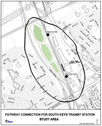
FIGURE 1- General Study Area
![]()
MAJOR ISSUES TO BE ADDRESSED
Some of the major issues to be addressed during the
course of this study include:
Potential Grade Separation
Requirements
The coordination of grade separation requirements at
the Airport Parkway and Transitway may be required. Grade separation scenarios will be developed that complement the
scenic route and gateway theme of the Parkway and could include scenarios that
provide for signalized at-grade alternatives employing signal priority for the
South Keys Transit Station.
Alternatives will include consideration of accommodating the proposed
future extension of the North-South LRT line.
The selection of location(s) for the pathway
connection to the Parkway and Transitway will require the evaluation of impacts
on the natural and green space/recreational corridor that forms part of the
Sawmill Creek Constructed Wetland. In
addition, safety, aesthetic value, and functional and security issues revolving
around the Transitway and airport operations, and emergency response will be
investigated and addressed throughout the course of the study.
South Keys Transit Station and Shopping Centre
Integration
The proposed integration of the South Keys Transit
Station and South Keys Shopping Centre with the pathway will have to consider
the Transitway BRT function and the eventual LRT and BRT expansions. This study will determine a preferred
alignment and profile of the pathway, and address a number of issues,
including:
q
Compliance
with Airport Parkway design goals and strategies
q
Compliance
with Transitway Design Guidelines and future LRT Requirements
q Aesthetic considerations
q Trail location, access
points and configurations
q Effects on the adjacent
residential community and commercial development
q Integration with the
existing pedestrian and cycling environment, including safety and access
considerations
q Effect on cycling
q Access to adjacent land uses
q Impact on underground and
overhead utilities and services, both existing and proposed
q Possible shared use of
facilities
PROJECT SCOPE,
TASKS AND DELIVERABLES
1.0 General
This project will be consistent with the approach and requirements set out in the Environmental Assessment Act. Since there may be a requirement for Federal land, permits and funding, the project must also comply with the requirements of the Canadian Environmental Assessment Act (CEAA). This project must satisfy both Provincial and Federal act requirements through a co-ordinated process to avoid duplication of effort.
1.1 Study
Area
The EA study area shown in Figure 1 will encompass those lands east of
Plante Street to the South Keys Shopping Centre, north of Hunt Club Road to the
CNR rail line. However, some study
tasks will require examination of a broader area, beyond these limits in order
to address environmental impacts and operational issues; to coordinate with
relevant on-going studies and projects; and, to study and identify tie-ins to
future network connections such as drainage and environmental influences on the
Sawmill Creek Constructed Wetland.
In addition to the general study area it is
appropriate to identify the major segments of the study area that address
different needs within the planning context.
The study area will be identified more clearly early
in the study process, however it may be modified accordingly to respond to new
information and conditions as they emerge.
The study will establish the requirements of the
connecting links for pedestrian and cycling access and identify any
Right-of-Way requirements and easements for the alignment.
1.2 Timing
The study is expected to be completed within approximately 10 to 12
months of consultant selection.
1.3 Coordination
with Other Studies
The EA Study process will take into consideration
any information including analysis and findings of previous and concurrent
transportation, development and infrastructure projects that could influence
the direction and/or conclusions of the Study.
Relevant background material will also be collected and reviewed.
2.0 Environmental
Assessment Study Tasks
The major study tasks are summarized as follows:
2.1 Project
Need
In order to reaffirm the Hunt Club Secondary Plan,
this study will assess and evaluate the need to provide the pathway
connection. The key components of this
stage include:
q Identifying and assessing
future travel demand including the benefits to transit ridership and access to
the South Keys Shopping Centre
q Identifying current and
projected transportation problems and opportunities within the study area
q A travel-forecasting
component that will identify and estimate the need for pedestrian and cycling
travel in the area. The analysis must
incorporate the principles of the TMP
q Consideration of the
implications of any corridor specific needs and/or constraints on crossing
roadways
This analysis will be used to identify all
reasonable alternatives to the undertaking.
2.2 Environmental
Inventory/Existing Conditions
An inventory of the social, economic, physical and
natural environments within the study area will be compiled. The inventory will consider all available
background material and where necessary, supplement this information through
on-site surveys and/or detailed studies.
In general, the inventory will identify and describe
those aspects of the environment that could potentially affect, or be affected
by, the undertaking. Some of the
specific aspects of the environment associated with this project include:
q Effects on the Sawmill Creek
Constructed Wetland
q Effects on green spaces and
natural areas
q Adjacent communities
including Hunt Club and South Keys
q Current and future cycling
and recreational pathway corridors/routes
q Potential influence of the
project from/on development patterns in the area
q Current storm water drainage
patterns
q Subsurface (geotechnical)
conditions
q Utilities including water,
sanitary, hydro, gas, cable, phone, fibre optic
q Heritage and archaeological
conditions
The existing conditions and proposed works
associated with the pathway connection will be documented before undertaking
the evaluation of alternative solutions.
The inventory must be completed for the entire study
area so that as alternatives are developed and analyzed, the cumulative effects
can be examined. The complete
inventory will be clearly described and documented within the final report.
2.3 Evaluation
Criteria and Evaluation Process
A comprehensive list of evaluation criteria and
methodology will be developed and used to evaluate the various alternative
solutions and designs. Refinements may
be made to the evaluation process in order to accommodate changing conditions
or circumstances as they arise.
2.4 Alternatives
to the Undertaking
Developing and examining a full range of options
complies with the EA Act requirement that all reasonable alternatives to the
undertaking be assessed. The
alternatives will be analyzed and evaluated based upon various criteria and
indicators to assess the impacts (with consideration to possible mitigation
measures) on the environment and to recommend a preferred alternative
solution.
The key components of this stage include:
q Identify alternative
solutions to address transportation problems.
Examples include:
o
Do
nothing
o
Restrict
pedestrian and cycling access between the two land uses/areas
o
Provide
a pathway link between the two land uses
o
Provide
an alternative using existing/proposed pathway connections within the public
right-of-way
o
Implement
specialized signalization for controlled access, safety and efficiency of
circulation.
q Develop evaluation criteria
and indicators to assess the impacts (with consideration to possible mitigation
measures) on the environment by the various solutions
q Analyse and evaluate the
alternative solutions and select the preferred solution(s) that best meet the
needs
Alternative solutions will be developed with input
from the Consultation Groups and will be presented to the public for comments
(see section on Public Consultation Plan).
2.5 Selection of Design Alternatives
Provided the preferred solution involves provision
of new pathway infrastructure, the Consultant will identify and evaluate
various design alternatives.
The pathway alignment and
cross-section design alternatives will be identified based on consideration of
constraints within the study area, input from the public and approval agencies,
landowners, as well as City guidelines/standards/practices. All proposed designs will include any
required modifications on crossing/connecting roadways, either public or
private.
The pathway interface with the Transitway and potential LRT
corridor extension will address various grade separation and station
modifications that will provide for ease of transfer between modes while
integrating with future development plans.
2.6 Recommended Plan
The alternative designs will be assessed and
evaluated as to their affects on the natural, social, urban, economic and
transportation environments. To ensure
that all of the impacts are identified, the necessary investigations such as:
noise, air quality, vibration, heritage and archaeological, natural areas and
wildlife habitats, storm water management, geotechnical, traffic impacts,
accessibility and safety, urban and landscape design, property impacts and any
other research that would be required to properly define the effects of the
facility will be carried out.
The alternatives will be compared to each other with
the ultimate goal of determining a recommended design. This exercise will be carried out with
input from the study Consultation Groups.
Following the evaluation of alternatives and determining all necessary
mitigation measures to minimize any adverse impacts, a recommended design will
be prepared and the results will be presented at a final Open House.
Upon receipt and incorporation of public feedback,
the recommended design will then be developed to a sufficient level of detail
as required to produce a functional design plan that is adequate for
submissions for project approvals in principle and to establish a complete
scope of work, baseline budget and implementation schedules for the entire
project. The recommended plan will
incorporate the functional design plan and will include but may not necessarily
be limited to:
q A written
description of the undertaking including the design parameters.
q Functional
design drawings (plan and profile) for the preferred alignment with a
coordinated centerline and property envelope, structural general arrangement
drawings
q Cross-section
drawings for typical sections as well as critical areas (e.g. Airport.
Airport Parkway connections, etc.);
q Implementation
(phasing) plan
q Recommended
mitigation measures to reduce the environmental impacts of the project
q Storm
water management requirements
q Cost
estimate of the proposed works (prepared in the WBS format) for
budgeting/funding purposes
The Recommended Plan will clearly identify and set
out the requirements and timing for all subsequent approvals required to
proceed with the construction phase of the project.
2.7 Environmental
Assessment Report
The study findings and recommended design with mitigation
plans will be presented to the Transit Committee for approval. A Draft and
Final Environmental Study Report (ESR) will be prepared to document the entire
study process including the recommended design and any appropriate mitigation
plans, amending procedure, costing, and implementation and Staging Plan, and
commitments to future action, including external approvals known to be
required.
The final ESR, incorporating all pertinent comments, will
be prepared and placed on public record for a minimum 30-day review
period. The Consultant will be
available to address any issues as they arise during this review period. Reference copies of the report will be made
available at local libraries, City Hall, City Client Service Centres and the
MOE Regional and/or District office.
2.8
Federal EA Project Description
Report
Federal permits, lands and funding may be sought before
project implementation can proceed. In
order to expedite the future federal approval processes, the City and EA study
consultant will initiate discussions with the relevant federal Responsible
Authorities (RAs) to identify all federal EA requirements and initiate the
federal EA screening process. This will ensure that all relevant existing
environmental inventory data collected and impact assessments carried out
during this assignment are scoped sufficiently to address federal EA screening
requirements.
The consultant will prepare a federal Project Description
Report containing a written description and general arrangement drawings for
the project in accordance with the requirements of the federal RAs. The report
will include enough information on potential impacts, mitigation measures and
conceptual compensation strategies to allow the federal agencies to conclude on
the significance of environmental effects at this early planning stage.
3.0
Consultation
This study will involve a number of stakeholders, including community
groups, property owners, businesses, institutions, approval agencies and
special interest groups. Early in the
study process stakeholders will be identified. This will be accomplished
through various forms of consultation, including liaison with City Councillors,
community associations, approval agencies and public notification.
The consultation program will primarily consist of
meetings with stakeholders, individually and through Consultation Groups, and
meetings with the public through Public Open Houses. Consultation Groups will meet with the Study Team at key stages
to review and comment on specific issues, the study progress and findings. Two consultation groups will be established,
namely:
q Public Consultation Group
(PCG)
q Agency Consultation Group
(ACG)
The membership, roles and responsibilities of each
Consultation Group will be outlined and communicated to each prior to meetings
taking place.
Specific aspects of the
consultation program are detailed as follows.
3.1 Public
Consultation Group
A Public Consultation Group (PCG) will be formed to enable
private groups to provide direct input to the study, advising and commenting on
local issues and concerns. PCG members
may include representatives from local community groups, area business
representatives, special interest groups, and adjacent property owners
including representation from each of the following groups:
q Hunt Club
Community Association
q South
Keys/Greenboro Community Association
q Pedestrian and Public
Transit Advisory Committee
q Roads and Cycling Advisory
Committee
q Accessibility Advisory
Committee
q Environmental
Advisory Committee
q South
keys Shopping Centre
q Other
interested groups or persons identified during the development of the study
design, or that come forward during the course of the study
3.2 Agency
Consultation Group
An Agency Consultation Group (ACG) will be formed to
address the full range of technical and policy issues and to comment on all of
the special studies required to fully assess the various alternatives and to
ensure that the City is following the procedures, legislation and addressing
appropriate policies. ACG members will
include experts in their related fields from government agencies and approval
bodies including, but not limited to:
q National
Capital Commission
q Department
of Fisheries and Oceans
q Rideau
Valley Conservation Authority
q City of
Ottawa
o
Public Works and Services Department
§
Traffic and Parking Operations Branch
§
Surface Operations Branch
§
Infrastructure Services Branch
o
Planning, Transit and the Environment Department
§
Planning Branch
§
Transit Services Branch
o
Business Transformation Services Department
§
Real Property Asset Management
o
Community and Protective Services Department
§
Ambulance, Fire
o
Police Services
q Ontario
Ministry of the Environment
q Ontario
Ministry of Natural Resources
3.3 Notifications
The public will be notified of: the Study
commencement, all Public Open Houses (POHs) and the submission of the EAR for
Ministry approval. Notifications will
be sent out at appropriate stages in the Study, and each announcement will take
the following forms:
q Advertisements in daily
newspapers (The Ottawa Citizen, Le Droit)
q Advertisements in community
papers where appropriate
q The project web site on the
City’s web portal
3.4 Public
Open Houses
The Public Open Houses (POHs) will be held to present and
obtain feedback on existing conditions and alternatives to the undertaking, the
preferred solution and alternative design concepts, and the recommended plan.
Background and presentation material will include a
“Project Update Newsletter” which summarizes the information presented at the
POH and will be available for general distribution. Bilingual staff will be present during all Public Open House
meetings and all material presented at the POH meetings as well as the “Project
Update Newsletter” will be bilingual.
3.5 Project
Web Page
A
Project Information Web Page for the Study will be established on the City’s
external web site by City staff with the assistance of the Consultant. The
purpose of the Web Page will be to inform the public of the progress of the
study and upcoming meetings or activities, post the bilingual materials
presented at each Open House, and provide a point of contact for e-mail
correspondence. It is imperative that bilingual information for the Open House
be ready and posted on the day of each event.
3.6 Deliverables
The deliverables for the study include:
q Public Open House Summary
Reports – one for each of three Public Open House
q Project Web Page data – as
required
q Project Update Newsletter –
minimum of three
q Draft and Final
Environmental Assessment Reports (EAR)
q Functional design drawings
of the preferred design, including plans and profiles for recommended
alignments, proposed station layouts and elevation drawings, structural general
arrangement drawings, utility relocation details, storm water management plans,
landscape design plans, and property requirement plans
q Project
Implementation/Staging Plan, which will identify all future approval
requirements including those for property acquisitions and easements and other
property related matters
q Project capital and
maintenance costs in WBS format
q
Approvals in
principal as required by regulatory agencies