Report to / Rapport au :
Transportation Committee
Comité des transports
01 November 2007 / 01 novembre 2007
Submitted by / Soumis par : Nancy Schepers, Deputy City Manager /
Directrice municipale adjointe,
Planning, Transit and the Environment/ Urbanisme, Transport en commun et
Environnement
Contact Person / Personne ressource : Vivi Chi, Manager / Gestionnaire,
Transportation and Infrastructure Planning / Transports et planification des
infrastructures
Planning Branch / Direction de l’urbanisme
(613) 580-2424 x21877, vivi.chi@ottawa.ca
|
Ref N°: ACS2007-PTE-POL-0066 |
|
SUBJECT: |
Hope Side Road Extension (Richmond Road to West
Hunt Club Road) Environmental Assessment – statement of work |
|
|
|
|
OBJET : |
évaluation environnementALE
du prolongement du chemin hope side (du chemin Richmond au chemin WEST hunt
club) – Énoncé des travaux |
REPORT
RECOMMENDATIONS
That Transportation Committee approve the Statement of Work for the Hope Side Road Extension (Richmond Road To West Hunt Club Road) Environmental Assessment as detailed in Document 1.
RECOMMANDATION DU RAPPORT
Que le Comité des transports approuve l’Énoncé
des travaux lié à l’Évaluation environnementale du prolongement du chemin Hope
Side (du chemin Richmond au chemin West Hunt Club), comme il est expliqué dans
le document 1.
BACKGROUND
The 2007 Capital Budget approved funds to undertake the environmental
assessment (EA) study for the Hope Side Road Extension (Richmond Road to West
Hunt Club Road) this year.
The City’s Transportation Master Plan (TMP) identifies the Hope Side
Road Extension as a new two-lane road from Richmond Road to Highway 416, which
crosses the National Capital Commission (NCC) Greenbelt. It is identified as a
Phase 3 project–implementation between 2013 and 2021.
Growth in South Kanata, Stittsville, and the rural southwest has
resulted in increasing demand on the Richmond Road-West Hunt Club Road
corridor. Intersections such as
Stonehaven Drive at Richmond Road at the edge of the Bridlewood community have
exceeded their capacity, have undergone expansion and continue to have
significant impacts on the quality of life in the adjacent community due to
traffic congestion within the residential community.
The EA for this project is being brought forward to evaluate the issues
in the context of a larger study area and determine the appropriateness of the
earlier implementation of a component of the larger project as a means to
address diminishing service levels. On
a conceptual basis an initial component of the project could include a new
two-lane roadway from Richmond Road to Moodie Drive at the south edge of the
Greenbelt.
Prior to initiating retaining a consultant for this EA, staff seeks approval
from Committee on the Study Statement of Work (SoW), which identifies the level
of effort to undertake the work, and thus sets the study budget.
DISCUSSION
The SoW is described in
Document 1. It outlines the tasks to be undertaken for the Hope Side Road
Extension EA study, including consultation, and identifies the study
deliverables. Upon approval from Transportation Committee, the SoW will form
the basis for a call for proposals to the consulting industry.
This project will be carried
out as a Schedule ‘C’ Class EA (self assessment) as set out in the Municipal
Engineers Association: “Municipal Class Environmental Assessment” document.
As a significant portion of
the study area is situated within the National Capital Commission Greenbelt,
there will be a requirement for Federal permits and property to construct the project. Accordingly, the project must also comply with the
requirements of the Canadian Environmental Assessment Act (CEAA). Since this
project must satisfy both Provincial and Federal act requirements, a
co-ordinated process will be undertaken to avoid unnecessary duplication.
The Study Area will include
a primary zone that generally follows the south limit of the Greenbelt from
Richmond Road to Moodie Drive, and then follows along the west side of Highway
416 to West Hunt Club Road. A secondary
Study Area zone will extend to the Eagleson Road Corridor on the west, the West
Hunt Club Road Corridor on the north and the Fallowfield Road-Cedarview Road
Corridor on the south and east.
Some tasks will require
examination of a broader area beyond these limits in order to address
environmental impacts; operational issues; to coordinate with relevant on-going
studies and projects; and, to study and identify tie-ins to future network
connections.
Key considerations for the
Hope Side Road Extension EA study include the following:
- Detailed evaluation of transportation demand crossing the
Greenbelt
- Full evaluation of any potential impacts on wetlands and other
natural environment areas
- Minimized impact on Greenbelt lands
- Extension of Crownridge Drive from Grassy Plains Drive to Hope
Side Road
It is prudent to start this
study now due to the complex issues presented by the introduction of a new
corridor in or near the Greenbelt.
Transportation demand projections have shown a consistent requirement
for system expansion crossing the Greenbelt from the south half of the West
Urban Community, and it is important to establish the feasibility of this
corridor before additional communities such as the area currently being planed
by the Fernbank Community Design Plan are established with the Hope Side Road
Extension anticipated as a future corridor.
It is unlikely that the TMP
update will remove this project from the identified future requirements based
on growth projections, development applications to date and current traffic
demand.
STUDY TIMING
In accordance with established City practice
for the acquisition of services, a two-step process consisting of a Request for
Qualifications (RFQ) followed by a detailed Request for Proposals (RFP) will be
utilized. The RFP process will end with a contract award in early March 2008.
It is expected that it will take 18 months
after contract award to complete this study, which is consistent with industry
practice for projects of this scope and complexity.
ENVIRONMENTAL IMPLICATIONS
The study will identify
potential effects on the social, physical and natural environments. Alternative
solutions will be developed and their impacts will be evaluated. The study will
pay particular attention to identifying and assessing potential impacts on the
NCC Greenbelt – most notably the Stony Swamp. Appropriate mitigation measures
will be developed and post-mitigation environmental impacts will be determined.
RURAL IMPLICATIONS
The secondary Study Area includes the rural area bounded by Richmond
Road, Fallowfield Road and Cedarview Road.
This area has been included in the scope of the study to ensure that any
potential impacts (i.e. noise, vibration, air quality, drainage) are fully
considered in the development and evaluation of alternatives.
CITY STRATEGIC DIRECTIONS
The recommendations contained herein directly support the following
2007-1010 City Strategic Directions adopted by Council on 11 July 2007:
F4 Ensure that City infrastructure required
for new growth is built or improved as needed to serve the growth.
CONSULTATION
Consultation will be an integral part of the EA
process. This study will
involve a large number of stakeholders, including community groups, property
owners, businesses, institutions, approval agencies and special interest groups
as described in the Consultation Section of the Statement of Work (Section
4.0). Early in the study process stakeholders will be identified through
various forms of consultation, including liaison with City Councillors,
community associations, approval agencies and public notification.
The consultation process will include meetings with
key stakeholders through the Agency, Business and Public Consultation Groups.
Consultation with the general public will occur principally through open house
meetings, but also through the project web page, and by e-mail. Additional
meetings with specific agencies, landowners, groups or individuals will also be
held as required to address any specific issues that may arise.
City staff have met with the local ward Councillor and NCC staff to introduce the project,
identify issues for consideration during the EA and discuss the public
consultation program.
FINANCIAL IMPLICATIONS
Funding for the Hope Side Road Extension EA study is currently
available in Order No. 902559, Environmental Assessment Studies – Arterial Roads.
SUPPORTING DOCUMENTATION
Document 1 Hope Side Road Extension (Richmond Road to West Hunt Club Road) Environmental Assessment Study – Statement of Work
DISPOSITION
Following Committee approval of the attached
Statement of Work, the Planning, Transit and the Environment Department will
initiate the consultant selection process with the assistance of the Supply
Management Division.
HOPE SIDE ROAD
EXTENSION (RICHMOND ROAD TO WEST
HUNT CLUB ROAD)
ENVIRONMENTAL ASSESSMENT STUDY –
STATEMENT OF WORK DOCUMENT 1
Hope Side Road
Extension Environmental Assessment
Statement of Work
1.0 Introduction
The City of Ottawa is the
proponent of a Class Environmental Assessment (EA) to study the proposed Hope
Side Road Extension. This Statement of
Work (SoW) describes the City’s intentions with respect to the methodology,
public consultation and deliverables for the study.
2.0 Planning Context
The Hope Side Road Extension
was identified as a future roadway requirement in the former Regional Official
Plan (OP) in 1997 and was reconfirmed as a future need in the City’s 2003 OP
and the Transportation Master Plan (TMP).
The fundamental purpose of the Hope Side Road Extension is to provide
additional arterial capacity across the Greenbelt for the southern half (south
of Highway 417) of the West Urban Community (WUC). The additional arterial capacity will allow a redistribution of traffic
to reduce bottlenecks on the existing road network and accommodate the urban
development that has been planned and being implemented in the WUC of the City.
Guided by the Ontario Planning Act, the OP contains Council’s
objectives and policies for managing growth in Ottawa to the year 2021. The TMP establishes infrastructure and
program needs, and supporting policies for the City’s transportation system to
the year 2021.
The form and function of this transportation
facility will be determined through the EA process, which will satisfy the
requirements of both the Provincial and Federal EA legislation. The values and interests of the
public/community groups are key elements that will be considered in the evaluation
and decision-making process. Effective
consultation on the nature and form of the facility is fundamental to arriving
at the most appropriate solution.
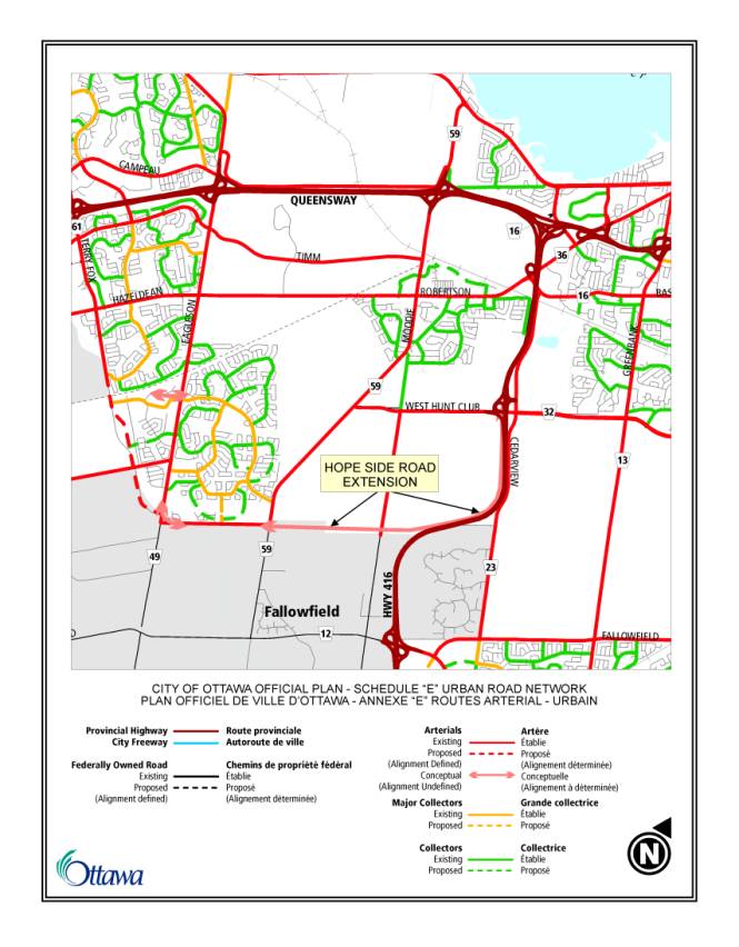
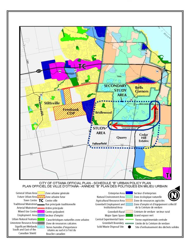
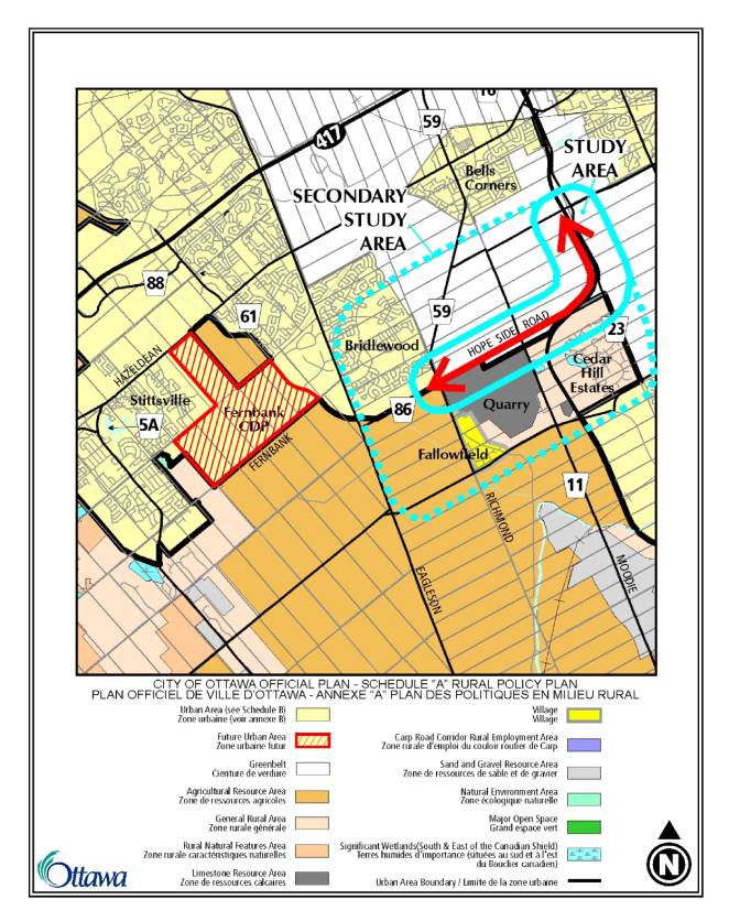
The conceptual location of
the Hope Side Road Extension is illustrated on the following excerpt from the
OP Schedule E - Urban Road Network, followed by excerpts from the OP Schedule B
– Urban Policy Plan, and OP Schedule A – Rural Policy Plan.
3.0 Work Plan
The major tasks for this
Class EA are proposed as follows:
3.1
Study Initiation
The Study Initiation will include liaison with
Provincial and Federal authorities responsible for EA reviews to obtain their
input on various EA requirements that must be met (specific to this
project). The Study Initiation will also
include consultation on; the description of the major tasks of the EA,
including a plan for development of alternatives as well as a process for
evaluation of these alternatives; include a detailed public consultation
program identifying the roles and responsibilities of the Agency Consultation
Group (ACG), and the Public Consultation Group (PCG), as well as timelines and
communication plan for the public Open Houses; high-light major milestones and
decision-making steps, and; consultation with the Advisory Committees.
3.2
Confirm the Need and Justification for the Hope Side Road Extension
Following the
Study Initiation, the Class EA work begins with the review of the need and
justification for the Hope Side Road Extension. Although the TMP investigated demand and identified the need for
additional arterial capacity, a re-examination of need and assumptions is
required under the Provincial EA Act.
This exercise will be carried out by forecasting travel demand for the
west end of the City and determining both existing and future needs for a
facility with respect to the impact on east-west travel demand/distribution,
economic benefits and links to major employment destinations.
An examination of future
traffic levels across screenlines and study area intersection level of service
will also supplement the review. The travel
demand analysis must consider various Transportation Demand Management (TDM)
trip strategies including enhanced transit service in the corridor in
accordance with TMP and OP policies.
3.3
Examine and Document Existing Conditions
As with every EA, an
inventory and assessment of the various existing conditions must be undertaken
at the outset. These include, but are not limited to:
·
transportation
·
land use
·
utilities
·
social/human environment
·
physical environment
·
natural environment
In addition,
the Study will include investigations of any special aspects of the Study
Area that should also be considered.
For example: the effects on green space and natural areas, natural /
recreational / agricultural uses in the NCC’s Greenbelt, the effects of noise
and air quality on the adjacent communities, any archaeological potential, and
the environmental/economic implications of construction in the vicinity of a
limestone resource area (Quarry). The
inventory must be completed for the entire study area so that as alternative
solutions and designs are developed and analyzed, the cumulative effects can be
examined. The inventory must also be
broad enough to fulfill both Provincial and Federal EA requirements.
3.4 Develop Evaluation Criteria and Evaluation
Process
To expand on the general
evaluation process developed at the Study Initiation, a list and description of
the evaluation criteria to be used to assess the various alternative solutions
and alternative designs, will be developed with input form both consultation
groups.
3.5
Develop Alternatives Solutions and Alternative Designs
The TMP recommends the Hope
Side Road Extension be a new two-lane arterial roadway. This Study will also investigate many other
alternate infrastructure and transportation solutions such as:
·
do nothing
·
implement transit/HOV lanes
·
mixed-use facilities
·
transportation demand management (trip reduction initiatives)
·
alternate routes (other corridors, such as Richmond – West Hunt Club)
·
park and rides
·
bicycle lanes, sidewalks and recreational paths
The different alternative
solutions and designs will be developed with input from City Advisory
Committees and will be presented to the public for comments at three Public
Open Houses throughout the Study (see section on Public Consultation Plan). Developing and examining a full range of
options complies with the EA Act requirement that all reasonable alternative
solutions for the undertaking be assessed.
3.6 Develop a Recommended Plan
The alternative designs developed in Task 3.5 will be assessed and
evaluated as to their affects on the natural, social, urban, economic and
transportation environments. To ensure
that all of the impacts are identified, it would be necessary to carry out
investigations such as: noise, air quality, vibration, natural areas and
wildlife habitats, stormwater management, geotechnical surveys, traffic
impacts, accessibility and safety, landscape design, property impacts and any
other research that would be required to properly define the cumulative effects
of the facility.
Alternatives will be
compared to each other with the ultimate goal of formulating a recommended
plan. This design would have to meet
the transportation needs while at the same time minimizing adverse affects to
the other environments (natural, social, urban, economic). The recommended plan could be one or a
combination of alternatives. Staging of
the recommended plan will also be considered.
The recommended plan will include a coordinated centre-line,
cross-section and configuration, property envelope, mitigation plan,
identification of next steps and approval, potential construction phasing, and
preliminary cost estimates for budgetary purposes.
3.7 Environmental Study Report (ESR) &
Environmental Screening Report
The Study deliverables will
include an ESR, which documents the entire class EA including the recommended
design and any appropriate mitigation plans.
A draft ESR will be circulated to the study consultation groups and any
other approval agencies, such as the NCC and MNR, for comment. The final ESR, incorporating all pertinent
comments, will be prepared and made available to the public for the formal
30-day Review Period as outlined in the Class EA requirements.
In addition to the ESR
required under the Provincial EA process, a Federal Project Description as well
as an Environmental Screening Report will also be produced as is required under
the Federal EA process. The EA will
include a cumulative impacts assessment of existing and planned transportation
infrastructure on the Stony Swamp and Bruce Pit Sector of the Greenbelt.
4.0 Consultation
Plan
There will be a
comprehensive communications and consultation effort to ensure that all
stakeholders are aware of the project and have an opportunity to provide input
and feedback in a timely manner. The
communications plan consists of Study notifications and the consultation
program.
4.1 Notifications
The public will be informed
of the study commencement, Public Open Houses (POH), and study completion. Notifications will be sent out at
appropriate stages in the Study, and each announcement will take the following
forms:
·
advertisements in daily newspapers (The Ottawa Citizen, Le Droit);
·
advertisements in community papers;
·
road signs along the study corridor (on Richmond Road at Hope Side
Road, and West Hunt Club Road at Highway 416, and Moodie Drive and Richmond
Road at the edge of the Greenbelt); and
·
City’s website – link dedicated specifically to this project.
The ward Councillor, and any
other Councillors that identify an interest in the study, will be informed in
advance of any public notification regarding this project. The ward Councillor, and any other
Councillors that identify an interest in the study, will also have the
opportunity to attend status update meetings as required, which will typically
be scheduled in advance of POHs.
In addition to study
notifications the Public Open House meeting will be documented in a Public Open
House Summary Report – one for each of three Public Open Houses, and the City
website will include a Project Update Newsletter – minimum of three to coincide
with the there key open house meetings.
4.2 Consultation
The consultation program
will consist of meetings with stakeholders through Consultation Groups,
meetings with the general public through POHs and a website dedicated to this
project.
Stakeholders will be
organized into various groups, which will meet with the Study Team at key
stages to review and comment on the Study findings. The Study Team’s Project Manager will chair each consultation
group meeting. The 2 consultation
groups are:
·
Agency Consultation Group (ACG)
·
Public Consultation Group (PCG)
4.2.1 Agency Consultation Group (ACG)
The ACG’s role will be to
address the full range of technical issues and to comment on all of the special
studies required to fully assess the various alternatives and to ensure
compliance with policies, master plans and legislation. The ACG will include experts in their
related fields from government agencies and approval bodies with representation
from the:
·
National Capital Commission (NCC)
·
Ministry of the Environment (MOE)
·
Ministry of Natural Resources (MNR)
·
Ministry of Transportation (MTO)
·
City’s Public Works & Services Department
à
Traffic and Parking Operations
à
Infrastructure Services
à
Surface Operations
·
City’s Planning, Transit & the Environment Department
à
Planning
à
Transit Services
à
Economic and Environmental Sustainability
·
Community & Protective Services
à
Fire Services
à
Parks & Recreation
·
Conservation Authorities
·
Ottawa Police Service
·
Other agencies identified through the consultation process
There
will be a number of meetings between the Project Team and ACG. They will include but not be limited to the
following areas for which the ACG will review and provide comments:
·
Information gathering, and issue identification
·
Preliminary development of alternatives to the undertaking and initial
screening of alternatives (modes and routes)
·
Refinement of selected alternatives and their detailed evaluation
·
Review of technically preferred alternative
·
Development of a recommended plan, including mitigation measures
4.2.2
Public Consultation Group (PCG)
The study area for the Hope
Side Road Extension spans several different communities with their own
characteristics, needs, and values. In
order to fully address both local and regional issues, a PCG will be
established. Generally, the PCG
membership consists of leaders of community associations, City Advisory
Committees and special interest groups that are directly affected by the
Project. Lists of groups and individuals
potentially affected by this project will be compiled with the assistance of
the adjacent ward Councillors. These
groups/individuals will be contacted upon commencement of the project to be
invited to join the PCG.
Similar to the ACG schedule,
the PCG will meet to review and comment on the findings at key stages in the
Study. The series of meetings will
mirror those identified in Section 4.2.1.
4.2.3 Project Website
A website will be established, hosted on the City’s home
page, ottawa.ca, that will contain all pertinent information about this
project. Notice of public meetings and
events, information bulletins and POH material will be posted in English and
French for review by the public.
4.2.4 Public Open Houses
In addition to the
Consultation Groups and the website, the Study Team will consult with the
general public at three-planned Public Open Houses (POH). Information for review and comment at these
formal POHs will generally include the following:
|
POH #1 |
POH #2 |
POH #3 |
|
· Introduction · Study Purpose · Need and
Justification · Study Process
& Schedule · Existing
Conditions · Alternatives to the
Undertaking · Evaluation
Criteria ·
Preliminary Screening of Alternatives ·
Next Steps |
· Development of
Options · Evaluation
Criteria · Assessment of
Options · Environmental
Effects · Next Steps |
· Recommended
Option · Mitigation Plan · Next Steps |
At all Open Houses, there will be bilingual representatives from the Study Team and all presentation material will be in both English and French.
4.2.5 Transportation Committee Meetings
At
the conclusion of the project, the study findings will be presented to the
Transportation Committee for approval, followed by Council approval.