Report to / Rapport au :
Transportation Committee
Comité des transports
and Council / et au Conseil
21 November 2007 / 21 novembre 2007
Submitted by / Soumis par : Nancy
Schepers, Deputy City Manager / Directrice municipale adjointe,
Planning, Transit and the
Environment/ Urbanisme, Transport en commun et Environnement
Contact Person / Personne ressource
: Vivi Chi, Manager / Gestionnaire, Transportation and Infrastructure Planning
/ Transports et planification des infrastructures
Planning Branch / Direction de
l’urbanisme
(613) 580-2424 x21877,
vivi.chi@ottawa.ca
|
Ref N°:
ACS2007-PTE-POL-0070 |
|
SUBJECT: |
INNES-WALKLEY-HUNT CLUB
CONNECTION ENVIRONMENTAL ASSESSMENT – STUDY RECOMMENDATIONS |
|
|
|
|
OBJET : |
ÉVALUATION ENVIRONNEMENTALE de la voie de RACCORDEMENT
INNES-WALKLEY-HUNT CLUB – RECOMMANDATIONS DE L’ÉTUDE |
That Transportation Committee recommend Council:
1. Receive the findings of the joint City/Ontario Ministry of Transportation Innes-Walkley-Hunt Club Connection Environmental Assessment Study as detailed herein;
2. Approve the Study Recommended Plan as illustrated in Documents 2(a) through 2(g) inclusive, and;
3. Direct staff to prepare the Environmental Study Report for the Innes-Walkley-Hunt Club Connection Environmental Assessment and post it for the 30-day public review period, in accordance with the Ontario Environmental Assessment Act.
Que le Comité des transports recommande au
Conseil :
1.
De
prendre connaissance des conclusions de l’étude d’évaluation environnementale
conjointe de la Ville et du ministère des Transports de l’Ontario concernant la
voie de raccordement Innes-Walkley-Hunt Club, qui sont énoncées dans le présent
rapport;
2.
D’approuver
le plan recommandé à la suite de l’étude, qui est illustré aux documents 2(a) à
2(g) inclusivement;
3.
De
donner instruction au personnel de rédiger le rapport d’étude environnementale
concernant l’évaluation environnementale de la voie de raccordement
Innes-Walkley-Hunt Club et de donner à la population la possibilité de
l’examiner pendant une période de 30 jours, conformément à la Loi sur les
évaluations environnementales de l’Ontario.
In January 2004, the City initiated an Environmental
Assessment (EA) study for the Innes-Walkley Connection to develop a Recommended
Plan for a facility that would address vehicular travel demand between the
City’s Eastern and Southern sectors.
At the same time, the Ontario Ministry of
Transportation (MTO) was carrying out an EA of the Queensway (Highway 417) from
Highway 416 easterly to Anderson Road, which initially included an interchange
at Hunt Club Road. The Ministry removed the interchange from the study scope
when it was deemed to not be a provincial requirement. However, in response to
City Council’s concerns, the MTO re-considered its position and agreed to
initiate the EA of the Hunt Club Road/Highway 417 interchange. The City then
extended the scope of the original Innes-Walkley Connection EA to include the
1.6 km extension of Hunt Club Road from Hawthorne Road easterly to the proposed
interchange, thereby ensuring that both facilities would be planned in an
integrated manner.
This report outlines the EA study findings and
presents the Recommended Plan for the Innes-Walkley-Hunt Club (IWHC)
Connection. The Recommended Plan establishes the form and function of the
future roadway as well as determining the property needs, and the effects and
mitigation on surrounding Study Area features.
The recommended facility is for generally a
curvilinear roadway incorporating design elements that will encourage
travellers to drive at a speed that respects the surrounding environment. This
‘Context Sensitive Design’ is
best described as a “greenway”, and was developed in consultation with the
National Capital Commission (NCC). The curvilinear alignment was established to
minimize NCC property requirements, reduce adverse impacts on environmentally
sensitive lands and achieve the design objective of creating a roadway facility
that is integrated with the Greenbelt.
The 7.0 km long facility is a four-lane divided
arterial with paved bicycle lanes provided in both directions. The roadway has
an urban cross section including a sidewalk on the north side, and a rural
cross section on the south side adjacent to NCC Greenbelt lands between
Hawthorne Road and the Highway 417 interchange. Beyond the Highway 417
interchange, the sidewalk on the north side of the road will connect to the NCC
Greenbelt pathway system.
Throughout the remainder of the Greenbelt, a
divided rural cross section will be used on the outside of the roadway in
combination with a variable width landscaped centre median. The variable width
median will enhance safety by separating traffic flows, reduce operating speeds
and provide opportunities for landscaping treatments.
The curvilinear alignment necessitates a large
‘ skew’ angle to cross Highway 417 that reduces the spacing to the Walkley Road
interchange to less than the desirable MTO standard. However, the MTO has
accepted this design to achieve the context sensitive design approach and
bundle the transportation and utility corridors in proximity to Highway 417.
A roundabout provides access to Walkley Road
and a physical traffic calming measure to lower operating speeds. It provides
an opportunity to incorporate a gateway feature and further reduces NCC land
requirements by locating the new road in proximity to the Highway 417 corridor.
Modifications to the existing Walkley Road ramps are required for continued
access to/from Highway 417 and the MTO has accepted these changes.
As the road continues north of Walkley Road, it
is located close to the Highway 417 right-of-way. A berm will be constructed to
eliminate headlight glare. At the northern end, the roadway parallels the
Green’s Creek ravine and terminates at Innes Road at a new signalized
intersection. Free-flow ramps will be provided for the dominant southbound and
eastbound movements.
A wide variety of issues were addressed during
the course of this study. Most issues were related and their interdependence
had a direct bearing on the study findings and Recommended Plan. These
included: addressing the need for the IWHC Connection; developing a Recommended
Plan that best integrates with the significant features and unique
characteristics of the study area, including the NCC Greenbelt; addressing the
concern for downstream impacts along Hunt Club Road, and; developing a phased
implementation strategy that prioritizes the connection from Hawthorne Road to
the Highway 417 interchange, and defers the northern portion of the project to
allow the City to complete planning for the project in conjunction with the
NCC’s update to its Greenbelt Master Plan.
As the principal landowner within the Study
Area, and a key project stakeholder, consultation with the NCC was critical to
success of this study. The NCC provided the City with Basic and Key Study
Principles, which significantly guided the undertaking. The Recommended Plan
adheres to the NCC’s stated Principles; however cumulative impacts issues,
strategic timing and a desire to further explore changes that could minimize
Greenbelt impacts will be further defined through investigations and the
completion of the Canadian Environmental Assessment requirements at the detail
design stage of the project. Consultation with the NCC will continue during
subsequent design and construction stages of the project.
This study harmonized the requirements of both
the Ontario MEA ‘Municipal Class Environmental Assessment, June 2006’
for the arterial road components under the jurisdiction of the City, and the
MTO’s Provincial Class Environmental Assessment for Transportation
Facilities, 2006 for the Highway 417 interchange at Hunt Club Road. It also
included the initial steps of the Canadian Environmental Assessment Act (CEAA)
process, as implementation of this project will require Federal permits and the
purchase of Federal lands, which trigger the need to satisfy Federal
legislation.
The preliminary cost estimate, in 2007 dollars, to design and construct this facility is $104 million apportioned over two phases.
The estimated costs for Phase I are as follows:
Hunt Club Road extension.................................. $17M
Highway 417 Interchange – Phase I.................... $23M
TOTAL............................................................ $40M
The estimated costs for Phase II are as follows:
Highway 417 to Innes Road............................... $45M
Highway 417 Interchange – Phase II.................. $19M
TOTAL............................................................ $64M
Funding for the detail design and Federal EA Screening for the Phase I project will be requested in the 2008 Capital Budget (Order No. 903176). Funding for the construction of Phase I will be identified beyond 2010 in the 2008 Capital Budget long range forecast. The City is negotiating cost-sharing arrangements with the MTO for the Phase I project.
Consultation began early in the process with a Value Planning workshop, which initiated dialogue between the City, NCC, MTO and other key project stakeholders.
The formal study consultation program consisted of meetings with project stakeholders, individually and through invited Technical and Public Advisory Committees, and meetings with the general public through three Public Open Houses (POH). A proactive and flexible approach to public and agency consultation was adopted in keeping with the needs and interests of key project stakeholders. Over the course of the study, regular update meetings were held with both study Advisory Committees to seek input, direction and concurrence on the study findings and recommendations.
The public expressed general
support for this project, with the Phase I extension of Hunt Club Road to the
Highway 417 interchange identified as a priority. The most commonly expressed
concerns related to the uncertainty of downstream traffic and noise effects
along the Hunt Club Road corridor, and the potential for impact on the
environmentally sensitive lands within the NCC’s Greenbelt, which are addressed
in detail elsewhere in this report.
En janvier 2004, la Ville a entrepris une étude
d’évaluation environnementale sur la voie de raccordement Innes-Walkley en vue
de l’élaboration d’un plan recommandé pour une installation qui devait
permettre de répondre à la demande de transport en automobile entre l’est et le
sud de la ville.
Parallèlement, le ministère des Transports de
l’Ontario (MTO) procédait à une évaluation environnementale qui portait sur la
partie du Queensway (autoroute 417) comprise entre l’autoroute 416 et le chemin
Anderson, dans l’est de la ville. Cette étude prévoyait initialement
l’aménagement d’un échangeur à la hauteur du chemin Hunt Club. Ayant constaté
que cet échangeur ne relevait pas de la province, le MTO l’a retiré de l’étude.
Après que le Conseil municipal lui eut fait part de ses préoccupations, le
Ministère a toutefois revu sa position et accepté de procéder à une évaluation
environnementale de l’échangeur du chemin Hunt Club et de l’autoroute 417. La
Ville a ensuite élargi la portée de l’évaluation environnementale sur la voie
de raccordement Innes-Walkley afin d’y ajouter le prolongement du chemin Hunt
Club en direction est sur 1,6 km, soit du chemin Hawthorne jusqu’à l’échangeur
projeté, assurant ainsi la planification intégrée des deux installations.
Le présent rapport énonce les conclusions de
l’étude d’évaluation environnementale et présente le plan recommandé pour la
voie de raccordement Innes-Walkley-Hunt Club (IWHC). Le plan recommandé définit
la forme et la fonction de la future route ainsi que les terrains nécessaires,
de même qu’elle précise les effets de la route sur les caractéristiques du
secteur visé par l’étude et les mesures d’atténuation prévues.
L’installation recommandée est une route en
forme de courbe comportant des éléments de conception qui inciteront les
automobilistes à rouler à une vitesse qui respectera le milieu avoisinant.
Cette « conception respectueuse du contexte », que l’on peut décrire
comme une « voie verte », a été élaborée de concert avec la
Commission de la capitale nationale (CCN). Le tracé incurvé a été retenu dans
le but de réduire au minimum la quantité de terrains appartenant à la CCN
nécessaire pour la réalisation de la route, de diminuer les effets néfastes sur
les terres écologiquement fragiles et d’assurer l’atteinte de l’objectif de
conception consistant à aménager une route intégrée à la Ceinture de verdure.
D’une longueur de 7,0 kilomètres,
l’installation projetée est une artère à quatre voies à chaussées séparées
dotée d’un couloir cyclable dans chaque direction. Il s’agit d’une route à
profil urbain avec trottoir du côté nord et à profil rural du côté sud, qui
donne sur la Ceinture de verdure, entre le chemin Hawthorne et l’échangeur de
l’autoroute 417. Au-delà de cet échangeur, le trottoir situé du côté nord de la
route sera raccordé au réseau des sentiers de la Ceinture de verdure de la CCN.
Ailleurs, le long de la Ceinture de verdure, la
partie extérieure de la route à chaussées séparées possédera un profil rural
avec terre-plein central de largeur variable doté d’aménagements paysagers. Ce
terre-plein de largeur variable contribuera à accroître la sécurité, du fait
qu’il séparera les véhicules circulant dans un sens et dans l’autre, réduira la
vitesse maximale réalisable et offrira différentes possibilités de traitement
paysager.
Le fait que la route possède un tracé incurvé
nécessite une grande « oblique » pour permettre le franchissement de
l’autoroute 417, de sorte que l’espacement avec l’échangeur du chemin Walkley
est inférieur à la norme souhaitable déterminée par le MTO. Celui-ci a
toutefois accepté cette formule afin d’assurer une conception respectueuse du
contexte et le regroupement des couloirs de transport et de services publics
dans le voisinage immédiat de l’autoroute 417.
Un rond-point donne accès au chemin Walkley et
constitue un élément de modération de la circulation visant à réduire la
vitesse maximale réalisable. Il offre la possibilité d’y intégrer une porte
d’entrée et réduit davantage la quantité de terrains de la CCN nécessaire, du
fait que la nouvelle route se situe dans le voisinage immédiat du couloir de
l’autoroute 417. Des modifications devront être apportées aux rampes permettant
d’accéder à l’autoroute 417 et d’en sortir à la hauteur du chemin Walkley, mais
le MTO a accepté ces changements.
Au nord du chemin Walkley, la route suit de
près l’emprise de l’autoroute 417. On y aménagera un talus afin d’éliminer
l’aveuglement causé par les phares des véhicules. À l’extrémité nord, la
chaussée suit le ravin du ruisseau Green, pour se terminer au chemin Innes, où
il est prévu d’aménager une intersection dotée de feux de circulation. Des
rampes sans conflit assurant l’écoulement libre des véhicules seront aménagées
pour les mouvements dominants (directions sud et est).
Un grand nombre de questions ont été examinées
au cours de l’étude. La plupart étaient liées et cette interdépendance s’est
répercutée directement sur les conclusions de l’étude et le plan recommandé.
Ces questions étaient les suivantes : nécessité de la voie de raccordement
IWHC; élaboration d’un plan recommandé assurant l’intégration optimale des
caractéristiques importantes et uniques du secteur visé par l’étude, y compris
la Ceinture de verdure de la CCN; répercussions de la route sur le secteur en
aval, le long du chemin Hunt Club; stratégie de mise en œuvre par étapes
accordant la priorité au raccordement du chemin Hawthorne à l’échangeur de
l’autoroute 417 et reportant la réalisation de la partie nord du projet afin de
permettre à la Ville d’en faire coïncider la planification avec la mise à jour
du Plan directeur de la CCN pour la Ceinture de verdure.
Comme la CCN constitue le principal
propriétaire foncier du secteur visé par l’étude et qu’elle est l’un des
intervenants clés du projet, il s’avérait crucial de la consulter afin
d’assurer le succès de l’étude. La CCN a communiqué à la Ville les principes de
base et les principes clés de l’étude, qui ont grandement contribué à orienter
cette dernière. Le plan recommandé respecte les principes énoncés par la CCN.
Toutefois, les études et l’évaluation qui sera réalisée aux termes de la Loi canadienne sur l’évaluation
environnementale au cours de la phase de la conception détaillée
permettront de mieux déterminer les effets cumulatifs du projet, d’en définir
le calendrier stratégique et d’examiner davantage des changements qui pourraient
réduire l’impact de la route projetée sur la Ceinture de verdure. Les
consultations avec la CCN se poursuivront au cours des phases ultérieures de la
conception et de la réalisation du projet.
Cette étude a donné lieu à l’harmonisation des
exigences du processus d’évaluation environnementale municipale de portée
générale (juin 2006) de la Municipal
Engineers Association of Ontario, pour les parties de la route relevant de
la Ville, et du processus d’évaluation environnementale de portée générale de
2006 du MTO concernant les installations de transport, pour l’échangeur de
l’autoroute 417 à la hauteur du chemin Hunt Club. Elle a également donné lieu à
la réalisation des premières étapes du processus prévu par la Loi canadienne sur l’évaluation environnementale,
étant donné que le projet nécessitera la délivrance de permis fédéraux et
l’achat de terrains fédéraux, d’où l’obligation de satisfaire aux exigences de
la loi fédérale.
Les coûts estimatifs préliminaires de
conception et de construction de cette installation (en dollars de 2007) sont
de 104 millions de dollars (somme répartie sur deux phases).
Coûts estimatifs pour la phase I
Prolongement du chemin Hunt Club.................... 17M$
Échangeur de l’autoroute 417 – Phase
I.............. 23M$
TOTAL............................................................ 40M$
Coûts estimatifs pour la phase II
Autoroute 417 jusqu’au chemin Innes................. $45M
Échangeur de l’autoroute 417 – Phase
II............ $19M
TOTAL............................................................ $64M
Le financement nécessaire pour la conception
détaillée et l’évaluation environnementale fédérale de la phase I du projet sera
demandé dans le budget d’immobilisation de 2008 (poste no 903176).
Le financement nécessaire pour la réalisation de la phase I fera partie des
prévisions à long terme contenues dans le budget d’immobilisation de 2008 (pour
la période au-delà de 2010). La Ville est en cours de négotiation avec le
MTO en ce qui concerne le partage des couts pour la Phase I du projet.
Les consultations ont débuté dès les premiers
stades de l’opération, prenant la forme d’un atelier de planification de la
valeur, qui a suscité un dialogue entre la Ville, la CCN, le MTO et les autres
intervenants clés du projet.
Le programme de consultation officiel a
consisté en une série de réunions avec les intervenants. On a tenu à la fois
des rencontres individuelles et des rencontres avec les comités consultatifs
techniques et publics invités, ainsi que des réunions publiques. La démarche
adoptée pour la consultation de la population et des organismes est une
démarche proactive et souple, qui tenait compte des besoins et intérêts des
principaux intervenants. Au cours de l’étude, des rencontres de mise à jour
régulières ont été organisées avec les deux comités consultatifs, afin
d’obtenir des opinions et des directives ainsi que l’acceptation des
conclusions et recommandations de l’étude.
Dans l’ensemble, la population s’est montrée
favorable au projet, accordant la priorité à la phase I, soit le
prolongement du chemin Hunt Club jusqu’à échangeur de l’autoroute 417. Les
préoccupations les plus fréquentes avaient trait à l’incertitude concernant
l’effet sur la circulation en aval et le bruit le long du couloir du chemin
Hunt Club, ainsi que les impacts potentiels sur les terres écologiquement
fragiles situées à l’intérieur de la Ceinture de verdure de la CCN, dont le présent
rapport traite de façon détaillée.
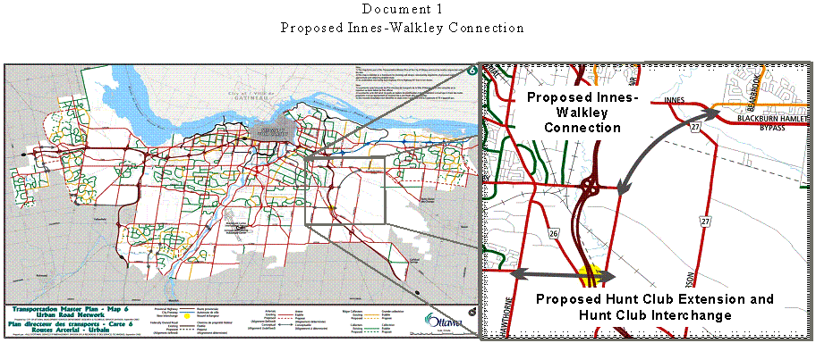
A conceptual link
between Innes and Walkley Roads was originally identified in the former
Regional Official Plan in 1997 and reconfirmed in the City’s 2003 Official Plan
and Transportation Master Plan (TMP). It is identified as a Phase I requirement
(construction by 2008) and is as depicted in Document 1. In January 2004, the
City initiated the Environmental Assessment for the Innes-Walkley Connection.
One of the first
study tasks was to undertake a Value Planning workshop with participants from
the City, the Ontario Ministry of Transportation, the National Capital
Commission and experts in the fields of transportation, and natural and social
environments. It provided an opportunity for key project stakeholders to
understand the need for the project, and recognize the various opportunities
and constraints within the Study Area such as the numerous environmental,
social and cultural features of the NCC’s Greenbelt. Extending the Study Area
to consider joining the Innes-Walkley Connection to the future Hunt Club
Road/Highway 417 interchange was one of the principal recommendations of the
Value Planning workshop, since the intent of this facility is to connect the
city’s eastern communities with developments in the south along Hunt Club Road.
As such, the study would use an appropriate traffic distribution model and in
doing so, identify the ideal location of the proposed Highway 417 interchange
and its potential connection to Ramseyville Road as depicted in the TMP.
At the same time, the
MTO was carrying out an EA of the Queensway (Highway 417) from Highway 416
easterly to Anderson Road. Initially, that study included the assessment of an
interchange at Hunt Club Road. However, the Ministry subsequently removed the
interchange from the study scope when it was deemed to not be a provincial
requirement. On 02 June 2004, the MTO presented an update on its EA study to
Transportation Committee. At that meeting Committee approved the following
motion, which was subsequently approved by Council and forwarded to MTO:
“That Council request that the Ministry of
Transportation recognize its obligation with respect to the Hunt Club/417
Interchange and include this work in the Design Study and Environmental
Assessment”
The MTO reconsidered
its position and agreed to initiate the EA of the Hunt Club Road/Highway 417
interchange. The City also agreed to include the study of the required 1.6 km
extension of Hunt Club Road from Hawthorne Road easterly to the Ministry’s proposed
interchange. This coordinated approach ensured that both facilities would be
planned in an integrated manner.
On 14 March 2005 City Council was advised that the City and the MTO
would proceed with an integrated study, and that the scope of the original
Innes-Walkley Connection EA study would be extended to include connections from
Walkley Road and Hawthorne Road to the Highway 417 interchange (to be referred
to as the Innes-Walkley Hunt Club Connection or IWHC).
The purpose of this EA was to develop a Recommended Plan for the IWHC Connection to meet the future travel demand of the East Urban Community in parallel with ongoing transit initiatives. This plan establishes the form and function of the future roadway as well as determining the property needs, and the effects and mitigation on surrounding Study Area features.
The majority of the Study Area is owned and managed by the NCC, which must approve any change of use of Federal lands in the National Capital Region. The NCC’s 1996 Greenbelt Master Plan provided guidance for land uses within the Greenbelt. This project, although identified in the City’s OP, is not included in the Greenbelt Master Plan. If this project is to proceed, an amendment to the Greenbelt Master Plan will be required including approval from the NCC's Board of Directors. As the NCC is currently embarking on a review and update of its Greenbelt Master Plan, the completion of this study is timely in that the City can request that the NCC include this project in the update.
Furthermore, Greenbelt Master Plan amendments must be presented to the NCC’s Advisory Committee on Planning, Design and Realty (ACPDR), which provides advice to the NCC’s Board of Directors on design proposals affecting Federal lands. In order to give approval for the construction of the IWHC Connection, Federal Land Use, Land Transaction and Design Approvals will be required from the NCC.
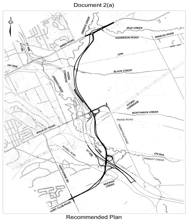
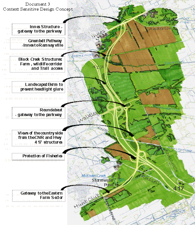
The Recommended Plan shown on Documents 2 (a) through (g) provides a solution that addresses near and long-term travel demands, while minimizing impacts to the Greenbelt. This 7.0 km roadway is generally curvilinear, incorporating design elements that will encourage travellers to drive at a speed that respects the surrounding environment (posted 60 km/h). This ‘Context Sensitive Design’ is best described as a “greenway” and is illustrated in Document 3. This philosophy and design principles were developed in consultation with the NCC.
The following description of the Recommended Plan begins at the southern connection with Hunt Club Road, and moves northerly and easterly past Walkley Road to its eastern terminus at Innes Road (i.e. a new intersection).
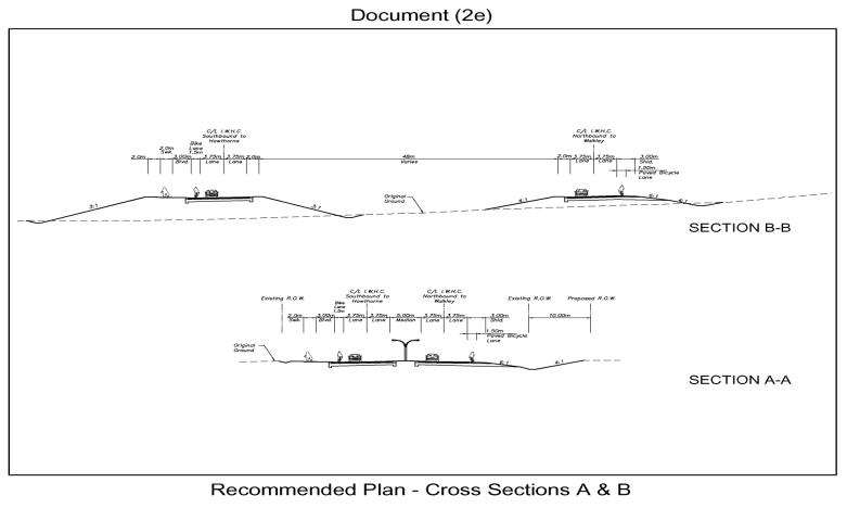
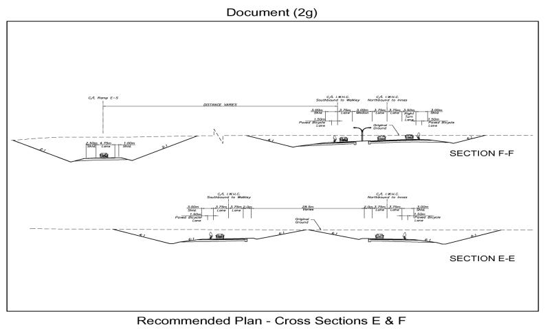
Between the Hunt Club/Hawthorne intersection and the Highway 417 interchange, the road consists of a four-lane divided arterial with an urban cross section including a sidewalk on the north side, and a rural cross section on the south side adjacent to NCC Greenbelt lands. Paved bicycle lanes are provided in both directions. Beyond the Highway 417 interchange, the sidewalk on the north side of the road will connect to the NCC Greenbelt pathway system.
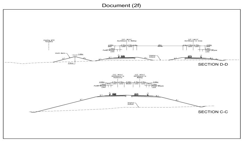
Throughout the remainder of the Greenbelt, a divided rural cross section will be used on the outside of the roadway in combination with a variable width landscaped centre median (that will not include a median ditch). The variable width median will enhance safety by separating traffic flows, reduce operating speeds and provide opportunities for landscaping treatments that will create a ‘parkway’ feel to the facility.
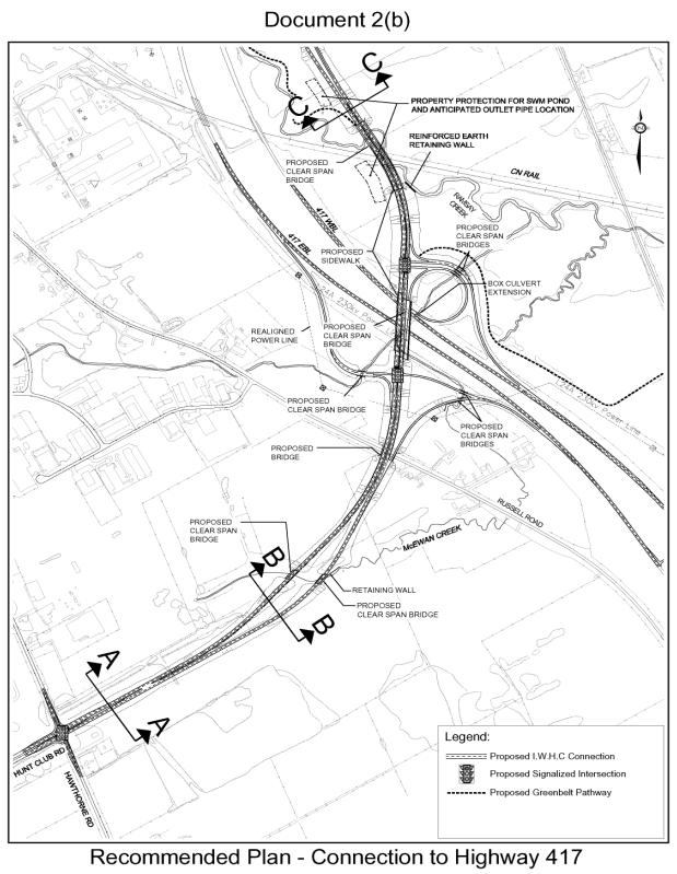
The curvilinear horizontal alignment was established to minimize NCC property requirements, reduce adverse impacts on environmentally sensitive lands and achieve the context sensitive design objective of creating a roadway facility that is integrated with the Greenbelt. As such, when the road extends easterly from the Hawthorne Road intersection, it transitions using horizontal and vertical curves in combination with introducing a centre median to create a gateway as it enters the Greenbelt. The horizontal alignment requires a larger skew angle to cross Highway 417.
From the height of the Highway 417 interchange, travellers in both directions will encounter new viewscapes of the Greenbelt to the northeast and southwest. The interchange crosses McEwen Creek and the roadway crossing will span the watercourse to avoid impacts to fish and aquatic habitat.
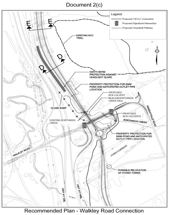
The roadway continues northerly from the Highway 417 interchange with bridge crossings over the CN Rail line and Ramsay Creek. Alterations to the creek are avoided through the use of retaining walls that reduce the footprint of the bridge embankments. From Ramsay Creek northerly the road gradually descends as it continues on a curvilinear alignment to Walkley Road. A roundabout provides access to Walkley Road and a physical traffic calming measure to lower operating speeds and reduce vehicular crashes. The roundabout provides an opportunity to incorporate a gateway feature and further reduces NCC land requirements by locating the new road in proximity to the Highway 417 corridor. Modifications to the existing Walkley Road ramps are required for continued access to/from Highway 417 and the MTO has accepted these changes.
As the roadway continues northerly it passes under Walkley Road through an open-span structure, which requires the profile of Walkley Road to be raised. The presence of a structure at this location also provides an architectural statement opportunity which will be explored during detail design. North of Walkley Road, Borthwick Creek will be realigned to the east, and incorporate plantings to re-establish a positive fisheries environment. Discussions with the Department of Fisheries and Oceans (DFO) and Rideau Valley Conservation Authority (RVCA) will continue during the design stage to examine measures to protect the fisheries and aquatic habitat and reduce effects during construction in this location.
As the route continues north of Walkley Road, the road rises along the periphery of the Old Dump Woods area, providing a new view northerly over agricultural fields and Green’s Creek, to the Gatineau Hills and southerly to the new gateway to the Greenbelt at Walkley Road. The road continues with an alignment near the Highway 417 right-of-way; a berm will be constructed to eliminate headlight glare.
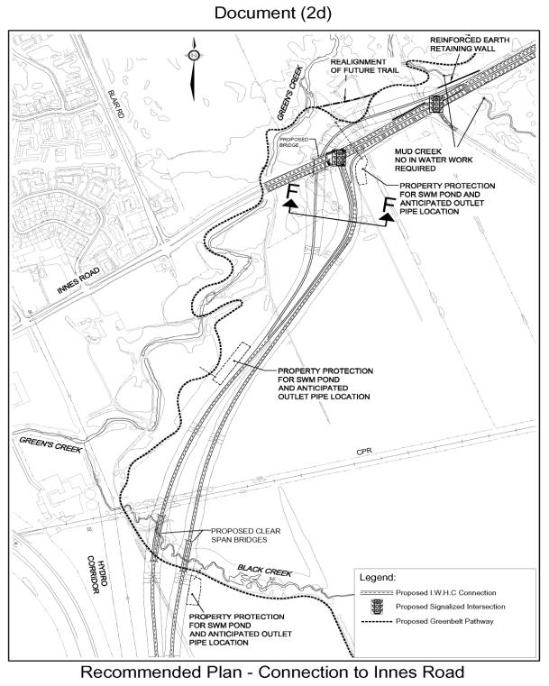
The roadway then parallels the Green’s Creek ravine and terminates at Innes Road at a new signalized intersection. Free-flow ramps will be provided for the dominant southbound and eastbound movements. Due to the sensitive clay soils in this area, the road is located a minimum 150 m away from the ravine to ensure that its construction does not adversely affect the stability of the slopes within the ravine. The southbound ramp will travel under Innes Road through a structure that will also provide an opportunity for a gateway feature into the NCC’s Greenbelt.
The City and the MTO have worked closely together throughout this study to ensure both City and Provincial interests were considered. Staff from both agencies consulted frequently, and participated on the study Technical Advisory Committee. Both parties achieved consensus on a range of technical issues, and worked as a unified team when addressing issues with external agencies such as the NCC, DFO, MNR and RVCA.
The MTO approved various technical design elements that were incorporated into the Recommended Plan in order to reduce impacts on features within the Study Area. A significant compromise among these was a reduction in the standard for desirable spacing between Highway 417 interchanges. As mentioned previously, to reduce the impacts to the NCC’s Greenbelt the interchange is ‘skewed’, reducing the spacing between the Walkley and Hunt Club interchanges to 1.7 km in the Recommended Plan. While this distance falls below desirable Ministry standards and will have a higher cost, it is consistent with the design philosophy of bundling the new roadway adjacent to the Highway 417 corridor to reduce impacts to the Greenbelt.
This study harmonized the requirements of both the Ontario MEA ‘Municipal Class Environmental Assessment, June 2006’ (as a Schedule “C” project for the arterial road components under the jurisdiction of the City of Ottawa), and the MTO’s Provincial Class Environmental Assessment for Transportation Facilities, 2006 (as a Group “B” Project for the Highway 417 interchange at Hunt Club Road).
This study also included the initial steps of the Canadian Environmental Assessment Act (CEAA) process, as implementation of this project will require Federal permits and the purchase of Federal lands, which trigger the need to satisfy Federal legislation. These permits are not obtained at the EA stage of the project, as detailed information is required which is beyond the scope of this study. However, the study findings will be used as input to satisfy all CEAA requirements, and to obtain NCC’s Federal Land Use and Design approvals during the detail design phases of the project.
The study process included the following tasks:
1. Needs Assessment – this initial task assessed the existing and future travel demands of the East Urban Community to/from the East and South urban sectors of the City to determine what infrastructure requirements exist. This work concluded that both roadway and rapid transit improvements will be needed in the future. Specifically the roadway improvements are required to satisfy deficiencies across the Green’s Creek screenline.
2. Alternative Solutions – this task developed and evaluated various means of solving the travel demands including rapid transit, travel demand reduction strategies, altering existing roadways and constructing new roadways. The evaluation determined that adding additional capacity to existing roadways such as Ottawa Road 174, Innes Road or Highway 417 will not provide the adequate level of service objectives across the Green’s Creek screenline. The preferred solution is a new roadway facility in combination with a transit initiative that will achieve a 41% mode split.
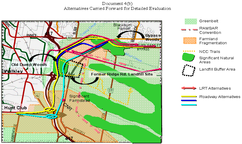
3. Alternative Designs – having determined that a new roadway is required, a range of alignment options were analyzed; it was concluded that one which connects Innes Road east of Green’s Creek to Walkley Road, extends southerly to a new interchange on Highway 417 and connects to the Hunt Club Road/Hawthorne Road intersection was the technically preferred design. Documents 4a and 4b illustrate the alternative designs considered and evaluated.
4. Effects and Mitigation – the effects of the technically preferred design were examined to determine refinements and/or mitigation that could be incorporated into the plan to minimize impacts to the surrounding environments. Refinements included clear-span bridges over key watercourses to avoid fisheries impacts, and alignment refinements to bundle the roadway in close proximity to the Highway 417 corridor to reduce lands required from the NCC and any detrimental effects to the Greenbelt.
The final step in the study process is to document the Class EA study findings, including all consultation, the Recommended Plan and any appropriate mitigation plans, in a harmonized Environmental Study Report (ESR)/Transportation Environmental Study Report (TESR) which satisfies both the City and MTO requirements respectively. The ESR/TESR will be available to the public for the formal 30-day Review Period as outlined in the respective Class EA requirements.
A wide variety of issues were addressed during the course of this study. Most issues were related and their interdependence had a direct bearing on the study findings and Recommended Plan. These included:
Need for the IWHC Connection
The 2003 OP and TMP provide the blueprint for accommodating the anticipated travel demands resulting from population and employment growth. A significant portion of the forecasted population increase has been assigned to suburban communities outside the Greenbelt.
The future trips generated by the residents of the East Urban Community
(EUC) will be oriented in a manner that reflects the decentralization of
employment. Specifically, a large portion of the future trips generated to/from
the EUC will be oriented to the emerging employments areas south of Walkley
Road and in the vicinity of the airport. Transportation planning analyses
completed in support of the OP and TMP project that approximately 70% of all
new vehicular trips to/from the EUC would use the IWHC Connection, because they
are destined to the areas south of Highway 417 including the Walkley/Hunt Club
and Airport employment areas.
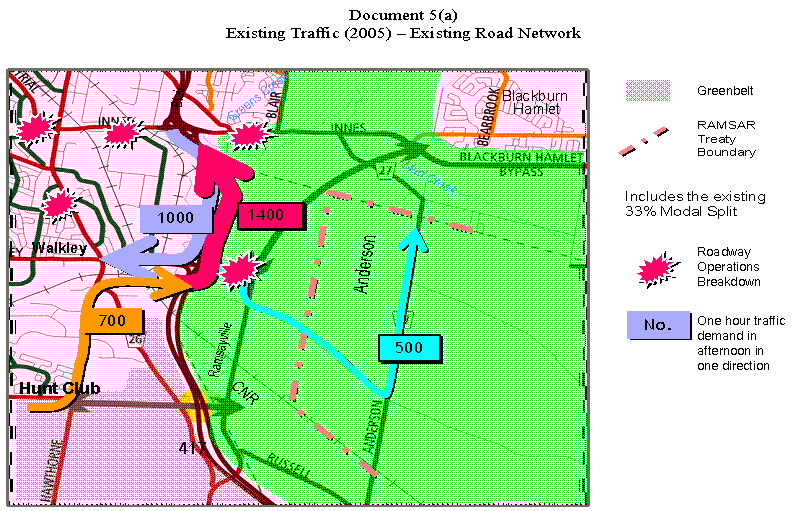
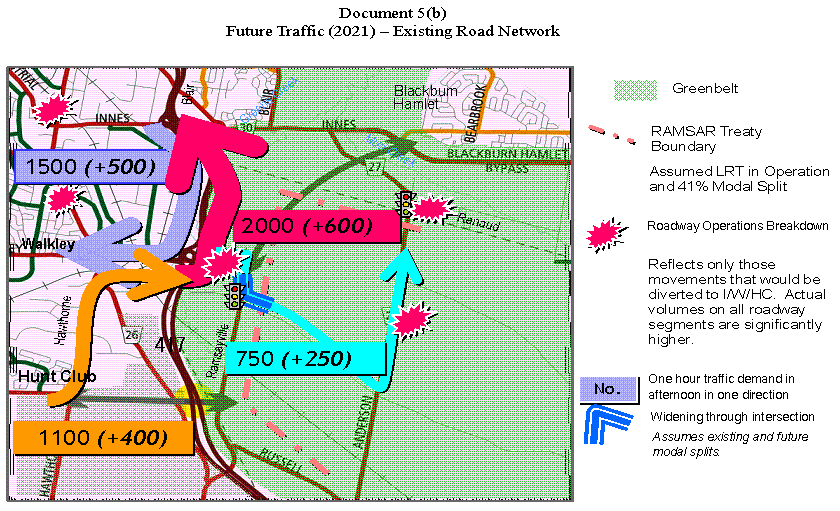
The need for the IWHC Connection considered transit, travel demand management and land use intensification as part of the detailed investigation into the transportation solutions. Transit, cycling and walking will form part of the overall transportation solution, with significant increases projected in these non-auto modes of travel. Nevertheless, roadway capacity improvements are required to accommodate the approved growth in the EUC. The TMP identified several facilities required to accommodate these long-term demands, including the East-West LRT, improvements to Innes Road and the construction of the Innes-Walkley Connection. Future traffic volumes will increase despite attaining the City’s future transit modal split goals as illustrated Document 5a.
Because of congestion on the arterial roads such as Innes Road and Walkley Road there are a significant number of vehicles using roadways within the Greenbelt. Approximately 500 vehicles (during the commuter peaks) now travel through the Greenbelt using Ramsayville, Ridge, Anderson and Renaud Roads to make the trip between the south and the east. These roadways were not designed to accommodate these volumes of traffic and exhibit operational and safety problems. If the additional capacity (i.e. the IWHC connection) is not provided, the current operational and safety deficiencies evident on these roads will increase.
In addition, the Walkley Road interchange is experiencing significant traffic volumes which have resulted in queues frequently extending onto the freeway. The end-of-queue collision potential is high when the queue extends into the through lanes of the freeway.
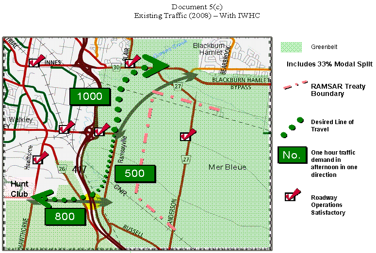
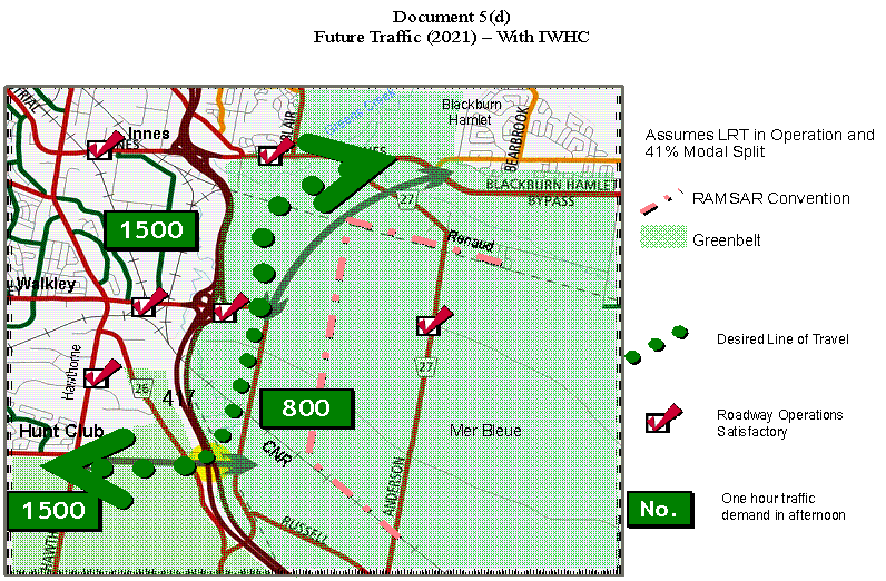
If additional capacity is not provided, the current deficiencies on all roads will worsen, as illustrated in Document 5b. Construction of the IWHC Connection with the associated Highway 417 interchange will redistribute existing and projected traffic volumes to this new roadway, as shown on Documents 5c and 5d
A range of alternative solutions were evaluated to address the travel demand, including:
The Highway 174 and Rockcliffe Parkway options were screened out, as they are not part of the desire line for travel and do not address the problem.
Providing the required screenline capacity on Innes Road requires widening the roadway to 10 lanes. This was deemed unreasonable from traffic, cost and social perspectives. In addition, the forecast demand could not be accommodated from the existing Innes Road/Highway 417 interchange.
Other alternatives to provide additional capacity included expensive and complex double lane ramps combined with ‘basket-weaves’ at both the Innes Road and Walkley Road interchanges and a new interchange at Hunt Club Road.
The provision of the IWHC and a new interchange was selected as the preferred solution.
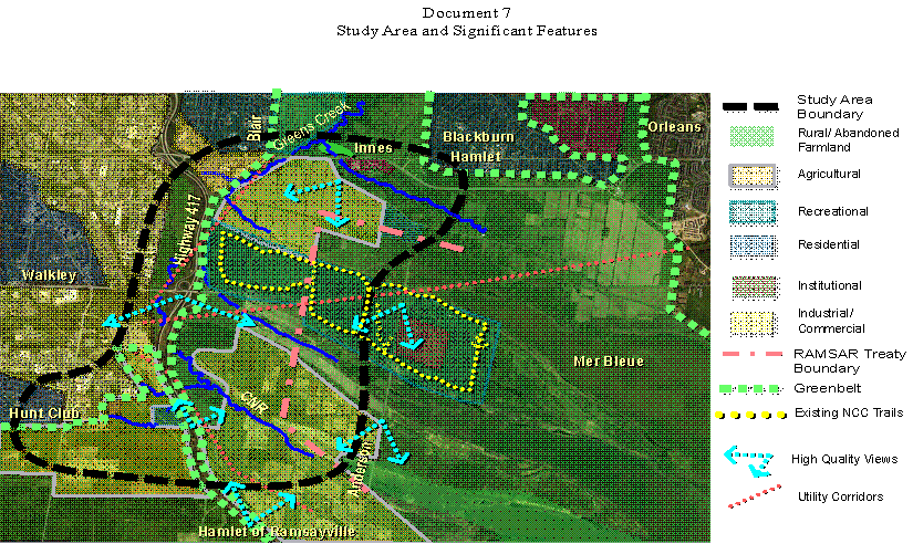
Study Area, the NCC Greenbelt and Significant Features
The Study Area generally extends from the Hawthorne/Hunt Club intersection north-easterly to the vicinity of the Innes/Anderson intersection. It lies entirely within the boundaries of the NCC’s Greenbelt, and incorporates many unique natural, cultural and historic features. Document 7 illustrates the Study Area and some of these features, including agriculture, recreation facilities, Mud and Green’s Creek ravines, numerous watercourses, areas of archaeological and historic potential, areas with sensitive clay soils and closed land fill sites.
The most significant feature in the Study Area is the Mer Bleue Bog, one of the largest in southern Ontario and considered to be the most important natural area in the Greenbelt. The bog is designated an internationally significant wetland under the United Nations’ 1971 Ramsar Convention on Wetlands.
An extensive on-site inventory and review of background documentation was undertaken. These features and their relative importance to social, natural and cultural environments were considered in the analysis and evaluation of the various alignment alternatives. A summary of the environmentally significant features and/or sensitivities within the Study Area includes:
The information collected and documented was applied to the detailed analysis and evaluation of alignment alternatives, the identification of recommended mitigation measures and to identify the remaining areas of concern associated with construction, operation and maintenance.
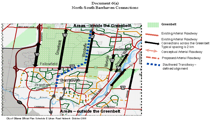
The Mer Bleue Bog is the largest constraint to providing additional east-west arterial road alternatives as well as the development of alignment alternatives. To illustrate this point, consider the existing north-south arterial roads that serve Barrhaven as shown in Document 6a. These roadways are based on the original lot and concession surveys, being spaced about 2 km apart. Note that Barrhaven is also well served by the Southwest Transitway. This combination of transit and road capacity provides Barrhaven residents with an efficient transportation network to serve their community.
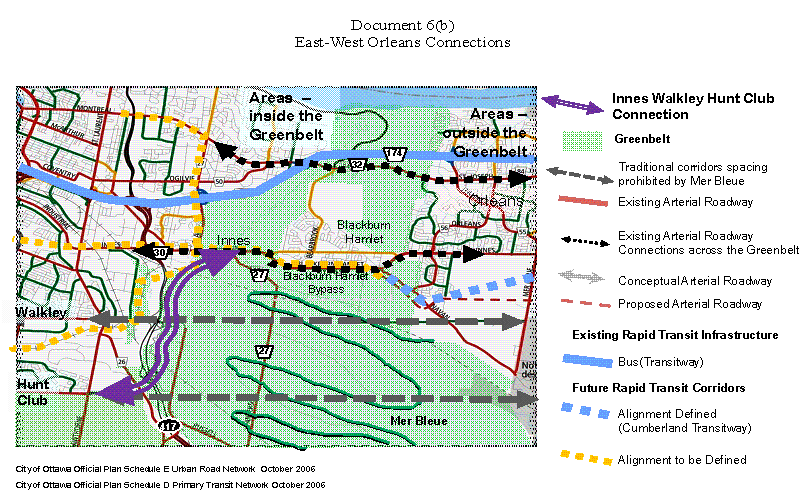
Document 6b provides a similar graphic illustrating the east-west transit and arterial road corridors serving the East Urban Community. There is similar arterial road spacing north of Innes Road, but to the south there are no east-west arterials because of the presence of the Mer Bleue Bog through which roads cannot be constructed. Therefore any arterial roadway connections extending from Hunt Club and Walkley Road (to serve the travel demands of the EUC) must detour around the Mer Bleue Bog. This generally emulates the alternative alignments developed for the Innes-Walkley-Hunt Club Connection.
The NCC advised that the terms and conditions of the Ramsar Convention on Wetlands prevented any consideration of the widening of Ridge, Anderson and Renaud Roads as an alignment alternative. In addition, widening these roads would not reduce the amount of cut-through traffic through the Greenbelt, which is desirable to the NCC.
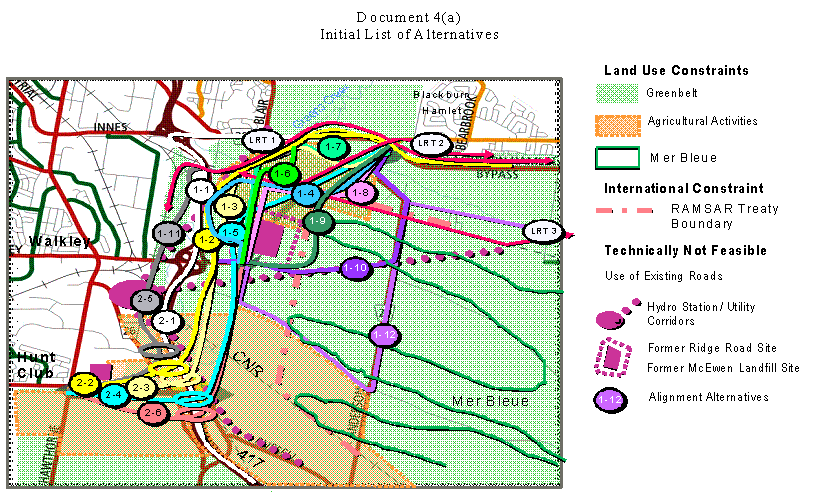
The Study Area was divided in to two separate sections to evaluate alternative roadway alignments. This division of the Study Area allowed the evaluation to consider unique environmental constraints that were generally common to each section.
In Section 1, 11 preliminary corridor alternatives were considered from Innes Road to Walkley Road. Three corridor alignments were carried forward for detailed analysis and evaluation, including the connection identified in the Official Plan for comparison purposes. In addition, Section 1 corridors included the East West Light Rail Transit corridor alignments then under consideration to address the NCC’s desire to bundle transportation facilities within one property corridor.
Six preliminary corridor alternatives were considered for Section 2, from Walkley Road south to the future Hunt Club Road, including the future Hunt Club and Highway 417 interchange. Corridors that encroached on the NCC’s Pine Grove farming sector, and those that impacted the Hydro One Hawthorne facility, were screened out early in the evaluation process. Two corridor alignments were carried forward to detailed analysis and evaluation including the proposed Hunt Club interchange.
The alternative alignments were evaluated using the following criteria:
The evaluation process resulted in the selection of a Technically Preferred Alternative (TPA) alignment. Refinements were made to the TPA based on consultation with the NCC, the study Technical and Public Advisory Committees, and the general public and became the EA Recommended Plan. Document 7 demonstrates how the Recommended Plan best integrates with its surroundings and the significant features; notably it:
The Recommended Plan also commits to further archaeological and natural environment investigations and approvals during detail design.
Downstream Effects
During the study consultation process several residents living in the communities adjacent to Hunt Club Road questioned whether there will be any traffic or noise impacts associated with the construction of this facility.
Construction of the IWHC Connection (Hawthorne to 417) is not projected to result in appreciable increases in traffic on Hunt Club Road. Several other roadways that cannot provide satisfactory traffic operation and safety are currently serving this demand. This traffic will move to the new facility when it is available, relieving congestion on other links in the Greenbelt and on Innes, Walkley and Hawthorne Roads.
Noise levels on Hunt Club Road west of Hawthorne Road were investigated as part of this study. The resultant noise level changes experienced by receivers adjacent to Hunt Club Road will be less than 1 dBA. Changes of this magnitude will be imperceptible to the average human ear. Based on the MTO and City of Ottawa Noise guidelines, no mitigation is recommended.
Project Phasing
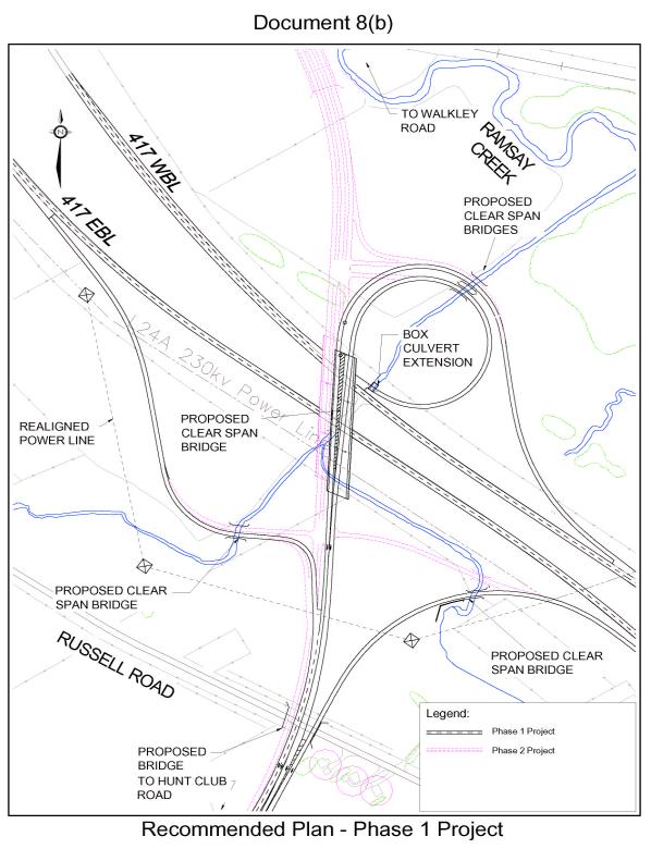
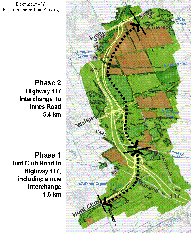
This EA Study will provide environmental clearance for the entire project with respect to the Provincial EA Act. Following the study, the proponents can choose an implementation plan subject to the availability of funding and receiving other required Federal Land Use and CEAA approvals. However, the EA document will present a recommended staging plan that will allow the implementation of the project by prioritizing the connection from Hawthorne Road to the Highway 417 interchange.
The implementation of these two facilities will address the current
operational and safety issues that exist on Hawthorne Road, Walkley Road and
the Walkley Road interchange. This phase will consist of a four-lane roadway
extending 1.6 km from Hawthorne Road easterly towards the interchange where it
will transition to a two-lane roadway connecting to the directional ramps at
the partial interchange.
This initial phase of the project will require a Federal EA, which will rely substantially on the work carried out during the course of this study. However, because the NCC has previously accepted this link, and land was transferred to the City through the 1996 Bridges Transfer Agreement for a portion of the new link, it is expected that this phase will require less NCC review than the new crossing of the Greenbelt. It will require a Federal Land Use Approval and amendment to the Greenbelt Master Plan but this is expected to be based on an NCC staff recommendation and may not require the NCC’s ACPDR or Board approval.
Phase 2
– Highway 417 Interchange to Innes Road
The second phase of the project includes the expansion of the Highway 417 interchange and a 5.4 km extension of the arterial roadway northerly to Innes Road. This link will divert traffic from the Innes Road Big Box area, and will significantly reduce traffic travelling through the Greenbelt. This phase will complete the Recommended Plan providing a four-lane connection to Innes Road and a link to the Blackburn Hamlet bypass. This will accommodate travel demand associated with growth in the EUC. This phase of the project will require a Federal EA, Federal Land Use and Design Approvals and an amendment to the Greenbelt Master Plan. Approvals from the NCC’s ACPDR and Board will be required. The NCC is planning an update to the Greenbelt Master Plan and this will provide the City with an opportunity to complete the joint planning of the project.
As previously described, the natural, social,
cultural and built environment were major factors considered in the development
of the Recommended Plan. These were mitigated through the analysis and
evaluation of alignment alternatives, which selected a plan that avoids
significant environmental features. Features such as the Mer Bleue Bog, the
various creeks and tributaries to Green’s Creek, and areas of significant
vegetation were considered constraints and avoided when developing the
Recommended Plan. For those features that cannot be avoided, the effects were
determined and appropriate mitigation measures have been proposed.
Specific environmental measures for stormwater
management, air quality and noise and vibration are described as follows:
The EA Recommended Plan identifies and accommodates
a number of stormwater best management practices, including linear grassed
ditches and stormwater ponds. The ESR/TESR states that specific stormwater
management techniques will be examined and incorporated into the detail design
such that the water quality in the creeks will be unchanged as a result of the
project.
In 2021, with projected population growth
(despite changes over time to vehicle emissions technology), there will be
increased traffic volumes that will increase total emission quantities of
carbon monoxide, oxides of nitrogen and hydrocarbons above levels that occur
today.
However, this Recommended Plan will reduce
these increased emissions by reducing the congestion on east-west trips to/from
the EUC that would have had a more circuitous route with greater delay
associated with numerous signalized intersections. The Recommended Plan
minimizes vehicle delay using grade separations and a roundabout.
As previously discussed, a noise impact
assessment was undertaken to assess sound level increases to noise sensitive
areas. Within the Greenbelt there are no noise sensitive receivers that will be
affected by the project. Downstream effects on Hunt Club Road or Innes
Road/Blackburn Hamlet are predicted to have no noise impacts that require
attenuation following either the City’s Noise Control Guidelines or MTO’s Noise
Protocol with the Ontario Ministry of the Environment (MOE).
The proposed Innes-Walkley-Hunt Club Connection
will provide a more efficient and less circuitous route for rural residential
and commercial travel across the city with new connections to Hunt Club Road,
Innes Road, Walkley Road and Hawthorne Road. This new link will also provide
improved rural residential and commercial access to Highway 417.
In addition, all existing rural residential
properties within the Greenbelt will benefit from the diversion of cut-through
traffic which is traveling through rural arterial roadways in the Greenbelt.
The farming
operations potentially affected by the IWHC Connection are all within the
Greenbelt on NCC property. The NCC leases these farms to local farm operators
and through consultation with them, no significant impacts will occur whereby
farming in the Eastern farm sector will become unfeasible.
The recommendations contained herein directly support the following Strategic Direction adopted by Council on 11 July 2007:
F4 Ensure that City
infrastructure required for new growth is built or improved as needed to serve
growth.
The study consultation program began early in the process with the afore-mentioned Value Planning workshop, which began the dialogue between the City and key project stakeholders.
The formal study consultation program consisted of meetings with project
stakeholders, individually and through invited Technical and Public Advisory
Committees, and meetings with the general public through Public Open Houses. A
proactive and flexible approach to public and agency consultation was adopted
in keeping with the needs and interests of key project stakeholders. Over the
course of the study, regular update meetings were held with both study Advisory
Committees to seek input, direction and concurrence on the study findings and recommendations.
Public consultation occurred at key study milestones to assist the study team in understanding local issues. The Public Advisory Committee (PAC) was made up of representatives from both Southeast and East end community associations and business groups.
The general public was invited to three rounds of Public Open Houses. Bilingual public notices were provided by newspaper (the Citizen, Le Droit) and on the City web site. City staff and consultant representatives were available to respond to any inquiries and each attendee was provided with a comment form and encouraged to provide a written response to any issues or concerns either at the POH or during the subsequent 2-week response period. The POHs are briefly described as follow:
In general, the public supports this project, with the Phase I extension
of Hunt Club Road to the Highway 417 interchange a clearly stated priority. The
most commonly expressed concerns related to the uncertainty of downstream
traffic and noise effects along the Hunt Club Road corridor, and the potential
for impact on the environmentally sensitive lands within the NCC’s Greenbelt,
which are both addressed elsewhere in this report.
As the principal landowner within the Study Area, and a key project stakeholder, consultation with the NCC was critical to success of this study. NCC staff participated on the study Technical Advisory Committee (TAC), and several additional meetings were held with NCC staff as the study progressed.
The following summarizes consultation undertaken with the NCC during this study:
·
NCC staff participated on the City’s consultant
selection process evaluation team.
· The NCC was a significant contributor at the VP Workshop held at the beginning of the study. Staff from various NCC departments including Greenbelt, Planning, Property, and Leasing provided a significant amount of expert information and advice to the study team.
· Following POH #1, the NCC provided the City with Basic and Key Study Principles, which significantly guided the remainder of the study. These Principles and the influence they had on the project are as follows:
|
Basic Principles |
Recommended Plan |
|
Demonstrate
need and examine alternatives to the undertaking. |
Based on the analysis, a range of transportation infrastructure improvements, including transit, cycling and walking will be required to satisfy the future mobility needs. Significant increases in these modes of travel are projected, nevertheless, the Innes-Walkley-Hunt Club connection will be required to accommodate approved growth in the eastern areas of the City. The Innes-Walkley-Hunt Club Connection will provide a more efficient and less circuitous route for travel from Hunt Club Road to Innes Road, and addresses current and projected travel demands in this area. |
|
Bundle infrastructure in corridors. |
The Hunt Club interchange spacing was reduced to a minimum distance to minimize the distance between the roadway and Highway 417. The roundabout, a structure under Walkley Road and removal of the westbound on‑ramp allow for bundling of the roadway and the freeway in the vicinity of the Walkley Road interchange. Constraints north of Walkley Road, including Hydro One restrictions for roads within tower corridors, soils constraints adjacent to the Green’s Creek ravine and minimizing impact to agricultural lands prevented bundling of corridors as successfully as the southern half of Study Area. |
|
Address cumulative impacts. |
Preliminary cumulative effects were examined. Reliable mitigation measures and avoidance of sensitive and significant features have drastically reduced the environmental impacts to the natural and cultural environments. Further investigations during detail design may further eliminate anticipated impacts. |
The Recommended Plan adheres in general to the NCC’s Basic Principles; however cumulative impacts issues, strategic timing and a desire to further explore changes that could minimize Greenbelt impacts will be further defined through investigations and the completion of the Canadian Environmental Assessment requirements at the detail design stage of the project.
The Recommended Plan strived to meet the following Key Principles required by the NCC:
|
Key Principles |
Recommended Plan |
|
Maintain viability of farmland. |
Affected farm buildings are relocated, field access is maintained, tile drainage will be accommodated. |
|
No net loss of ecological function for natural features. |
Ecological function of the Study Area will not be affected by the Recommended Plan. |
|
Maintain or enhance integrity of Mer Bleue and its buffer area. |
The Recommended Plan stays outside the Ramsar Treaty Boundary. |
|
Maintain trail network. |
Existing and future trail networks are maintained. The future Greenbelt Pathway will be constructed by the City of Ottawa to provide pedestrian access along the new roadway. |
|
Protect views and vistas. |
All identified views and vistas are protected. |
|
Create new views and vistas. |
New views and vistas are provided from the new interchange and Dolman Ridge. |
|
Impose no financial cost to the Commission. |
No costs to the NCC are anticipated. |
· As this project would require an amendment to the NCC’s Greenbelt Master Plan, presentations are required to the NCC’s Advisory Committee on Planning Design and Realty (ACPDR). The ACPDR is an advisory group to the NCC's Board of Directors, providing advice on long-range planning matters. Three presentations to ACPDR at key project milestones are required prior to an amendment to the Greenbelt Master Plan being approved. Two of three presentations were provided during the course of this study. A third will follow during detail design.
· The following is a summary of the presentations made to senior NCC officials by the EA Study Team regarding the Innes-Walkley-Hunt Club Connection:
ACPDR Presentation No. 1 – 03 February 2006. With the TPA developed, it was appropriate to introduce the study to the NCC’s ACPDR. This group received the presentation for information and provided preliminary comments on the refinements to the TPA being considered.
Executive Management Committee (EMC) Presentation – 16 May 2006. A similar presentation was made to the NCC Executive Management Committee. Similarly, this group received the background information of the study, the TPA, refinements to the TPA and concluded by recommending the project be presented to ACPDR a second time for their formal comments.
ACPDR Presentation No. 2 – 05 June 2006. This presentation included a summary of the project and discussed the major issues raised at ACPDR No. 1. The Context Sensitive Design Concept was presented. At that time ACPDR expressed the following four major concerns with this project:
The Recommended Plan developed addresses ACPDR’s Concerns 2 and 3. A cumulative impact evaluation process was used to define the best solution whereby corridors were bundled. Remaining effects that were not avoided through design refinements have suitable mitigation measures. However, the economic analyses listed were not completed as this would entail negotiation with NCC for property, which was not initiated in this study.
Modifications were made to all roadway design features such that the geometry of the facility fits within the context of the Greenbelt.
For Concern 1 it was deemed to be an issue more appropriately addressed outside of the EA study. The redevelopment of the Big Box area on Innes Road should be initiated by land owners or developers.
For Concern 4 the NCC’s advice was to prioritize transit first. This outstanding concern related to the northern section, Section 1, will be addressed at a later date as the City moves forward with it long range planning and update to the TMP.
Consultation with the NCC will continue during subsequent design and construction stages of the project. The City and the MTO are committed to considering the NCC’s stated principles regarding this project. Timely liaison with NCC staff will be carried out during the detail design to ensure that all planning, design and construction activities are acceptable to all stakeholders. Should the NCC initiate its update to the Greenbelt Master Plan in advance of Phase 2 of the project, then City staff will participate in the technical consultation of that study using this EA as input for that process.
A web site was developed and maintained for the IWHC Connection EA study on the City’s external web portal. The web site was used to inform the public of the study progress and interim findings and advise on upcoming meetings or activities. It also provided a point of access for public consultation and feedback. The web page provided links to all public notices and all display materials presented at each Open House, allowing residents who were unable to attend an opportunity to view all the materials.
It is accessible at http://www.ottawa.ca/public_consult/innes_walkley/index_en.shtml
A variety of refinements and modifications to the TPA were introduced
throughout the study process through direct consultation with the key project
stakeholders, approval agencies and the general public. The vast majority of
these modifications were aimed at addressing issues unique to the significant
features within the Study Area and the NCC Greenbelt in particular, and are
discussed elsewhere in this report.
In conjunction with the Department of Fisheries and Oceans (DFO), the Ontario Ministry of Natural Resources (MNR) and the Rideau Valley Conservation Authority (RVCA) further refinements were incorporated that reflected consideration for environmental features that further reduced anticipated impacts to fisheries, aquatic habitat and protect water quality. These refinements included the following measures:
For example, impacts to watercourses supporting populations of numerous warm water forage fish species were minimized by: incorporating retaining walls that reduce the footprint of fill slopes; using structures spanning creeks to avoid in-water work and maintain existing wildlife corridors; and utilizing and locating stormwater ponds at key locations to protect water quality.
A proposed realignment of McEwen Creek in the vicinity of the Hunt Club Road/Highway 417 interchange was avoided by modifying the interchange, utilizing a Diamond configuration in the southwest quadrant and lengthening the span of the creek structure, which required MTO review and approval.
The preliminary cost estimate, in 2007 dollars, to design and construct this facility is $104 million over two phases.
The estimated costs for Phase I are as follows:
Hunt Club Road extension.................................. $17M
Highway 417 Interchange – Phase I.................... $23M
TOTAL............................................................ $40M
The estimated costs for Phase II are as
follows:
Highway 417 to Innes Road............................... $45M
Highway 417 Interchange – Phase II.................. $19M
TOTAL............................................................ $64M
These cost estimates include an allowance for engineering, design and project management and also assume a value for land. A more detailed total project cost will be developed during detail design and incorporated into future budget submissions as required.
Funding for the detail design and Federal EA Screening for the Phase I project will be requested in the 2008 Capital Budget (Order No. 903176). Funding for the construction of Phase I will be identified beyond 2010 in the 2008 Capital Budget long range forecast. The City is negotiating cost-sharing arrangements with the MTO for the Phase I project.
The above-noted estimate for Phase II supersedes the $20.5M which appears in the 2008 Budget nine-year Capital forecast, as the EA estimate for Phase II was not available at the time the long range budget forecast was prepared.
SUPPORTING DOCUMENTATION
Document 1 Proposed Innes-Walkley Connection
Document 2(a) Recommended
Plan
Document 2(b) Recommended Plan – Connection to Highway 417
Document 2(c) Recommended Plan – Walkley Road Connection
Document 2(e) Recommended Plan – Cross Sections A to D
Document 2(f) Recommended Plan – Cross Sections E to G
Document 2(g) Recommended Plan – Cross Sections H to J
Document 3 Context Sensitive Design Concept
Document 4(a) Initial List of Alternatives
Document 4(b) Alternatives Carried Forward for Detailed Evaluation
Document 5(a) Existing Traffic (2005) – Existing Road Network
Document 5(b) Future Traffic (2021) – Existing Road Network
Document 5(c) Existing Traffic (2008) – With IWHC
Document 5(d) Future Traffic
(2021) – With IWHC
Document 6(a) North-South Barrhaven Connections
Document 6(b) East-West Orleans Connections
Document 7 Study Area and Significant Features
Document 8(a) Recommended Plan Staging
Document 8(b) Recommended Plan – Phase 1 Project
Following Committee and Council approval, the Department of Planning,
Transit and the Environment will complete the Environmental Study Report (ESR),
which documents the entire EA process and study recommendations, incorporating
any Council approved directions. The ESR will be made available for mandatory 30-day
public review, with notification through the posting of a ‘Notice of Study
Completion’ appearing in the Ottawa Citizen, Le Droit.
PROPOSED INNES-WALKEY CONNECTION DOCUMENT 1
RECOMMENDED PLAN DOCUMENT 2(a)
RECOMMENDED PLAN – CONNECTION TO HIGHWAY 417 DOCUMENT 2(b)
RECOMMENDED PLAN – WALKLEY ROAD CONNECTION DOCUMENT 2(c)
RECOMMENDED PLAN –CONNECTION TO INNES ROAD DOCUMENT 2(d)
RECOMMENDED PLAN –CROSS SECTIONS A TO D DOCUMENT 2(e)
RECOMMENDED PLAN –CROSS SECTIONS E TO G DOCUMENT 2(f)
RECOMMENDED PLAN –CROSS SECTIONS H TO J DOCUMENT 2(g)
CONTEXT SENSITIVE DESIGN CONCEPT DOCUMENT
3
INITIAL LIST OF ALTERNATIVES DOCUMENT 4(a)
ALTERNATIVES CARRIED
FORWARD FOR DETAILED
EVALUATION DOCUMENT
4(b)
EXISTING TRAFFIC (2005) – EXISTING ROAD NETWORK DOCUMENT 5(a)
FUTURE TRAFFIC (2021) – EXISTING ROAD NETWORK DOCUMENT 5(b)
EXISTING TRAFFIC (2008) – WITH IWHC DOCUMENT 5(c)
FUTURE TRAFFIC (2021) – WITH IWHC DOCUMENT 5(d)
NORTH-SOUTH BARRHAVEN CONNECTIONS DOCUMENT 6(a)
EAST-WEST ORLEANS CONNECTIONS DOCUMENT 6(b)
STUDY AREA AND SIGNIFICANT FEATURES DOCUMENT 7
RECOMMENDED PLAN STAGING DOCUMENT 8(a)
RECOMMENDED PLAN – PHASE 1 PROJECT DOCUMENT 8(b)