Report
to/Rapport au :
And Council / et au conseil
12 August 2010 / le 12 août 2010
Submitted by/Soumis par : Nancy Schepers, Deputy City Manager/Directrice
municipale adjointe, Infrastructure Services and Community
Sustainability/Services d 'infrastructure et Viabilité des collectivités
Contact Person/Personne ressource : John L. Moser, General Manager
Planning and Growth Management/Urbanisme
et Gestion de la croissance
(613) 580-2424 x,
john.moser@ottawa.ca
REPORT RECOMMENDATIONS
That the Transportation Committee recommend that Council:
1.
Direct the
Deputy City Manager, Infrastructure Services and Community Sustainability to
seek a cost-sharing agreement with the National Capital Commission for the proposed
multi-use pathway projects as identified in this report; and
2.
Direct staff
to include the list of proposed multi-use pathway projects in the City’s 2011
draft capital budget.
RECOMMANDATIONS DU RAPPORT
Que le Comité des
transports recommande au Conseil :
1.
de demander à la directrice
municipale adjointe, Services d’infrastructure et Viabilité des collectivités,
d’établir une entente de partage des coûts avec la Commission de la capitale
nationale dans le cadre des projets de sentiers polyvalents proposés, comme
l’explique le présent rapport;
2.
de demander au personnel d’inclure
la liste des projets de sentiers polyvalents proposés dans le budget
préliminaire des immobilisations de 2011 de la Ville.
BACKGROUND
The Official Plan (OP) and accompanying
Transportation Master Plan (TMP) place importance on strengthening existing
communities while developing new smart growth communities that are
environmentally sustainable, providing community-friendly transportation facilities
and integrate employment centres. As
directed by the City’s Strategic Plan, in 2008 City Council approved the Ottawa Cycling Plan (OCP). The OCP identifies the need to improve
existing off-road multi-use pathways and on-road cycling facilities and to complete
missing links in the City’s cycling network and provide connections to the
National Capital Commission (NCC) pathway network. The OCP network calls for 1,200 new kilometres
of bike lanes, multi-use pathways and paved shoulders.
The City,
through its current plans, policies, guidelines and implementation programs,
has ensured that pedestrian and cycling facilities are included in all new and
reconstructed roads. It is estimated
that between years 2000 and 2009 approximately 160 kilometres of new bike
lanes, paved shoulders and multi-use pathways have been added to the City’s
transportation infrastructure, excluding new pathway construction by the NCC. Furthermore, in 2010, the City has made
significant investments in its cycling and pedestrian network to close the gap
between planned and built pedestrian and cycling infrastructure and to provide
for multi-use pathways.
The NCC has
had a strong interest in the development of pathways, originally for greening
the capital and for recreational purposes.
However, with the development of the NCC’s Pathway Network for Canada’s Capital Region – 2006 Strategic Pathway
Plan, there has been recognition of the role NCC pathways play in
utilitarian cycling. The NCC, along with
its partners (chiefly the cities of Gatineau and Ottawa) proposed a framework
for the planning and development of the Capital Pathway Network for the next 10
years. This plan was built on the need
to ensure the pathway network will be multi-purpose, accessible and safe,
connect to other transportation networks to encourage sustainable
transportation and promote recognition of the National Capital Region (NCR) in
the greater international context.
The NCC pathway
plan, which was endorsed by City Council when presented in October 2006,
includes considerable intertwining of pathways with the OCP’s on- and off-road
cycling routes. In 2009, the NCC has
convened two committees (tripartite and regional) with representatives from the
various jurisdictions comprising the NCR in order to better coordinate and move
forward with the implementation of the 2006 Strategic Pathway Plan.
According to the 2006 Census, Ottawa-Gatineau was ranked first in
Canada as having the highest bicycle commuter mode share of large cities at 2.1
per cent, followed by Vancouver and Montreal at 1.7 per cent and 1.6 per cent,
respectively. However, Ottawa-Gatineau
is in danger of losing this status as both Montreal and Vancouver have been
making proportionately larger investments in cycling infrastructure in recent
years and both have introduced a variety of new cycling facility types not yet introduced
in Ottawa-Gatineau.
Since the
City’s and the NCC’s cycling facilities have been developed at different paces
over time, they consequently created gaps in the cycling network. The target for priority cycling projects for
2011 is to close as many of these gaps as possible. Therefore, this report proposes a list of multi-use
pathways for inclusion in the 2011 draft capital budget that will extend and
increase access to the existing NCR cycling network. Residents and visitors will benefit from increases
in sustainable transportation alternatives that create positive social and
environmental impacts, improving our quality of life, improving health
outcomes, and reducing greenhouse gas emissions.
DISCUSSION
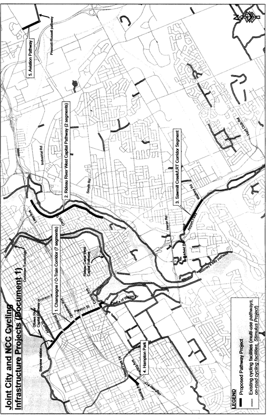
The proposed multi-use pathways below are recommended for inclusion in
the 2011 Draft Capital Budget as priority projects subject to a cost-sharing
agreement with the NCC:
1.
Champagne/O-Train
Corridor Pathway (parallels the O-Train corridor between Ottawa River and Dow’s
Lake);
2.
Rideau
River Western Pathway (Belmont Street to Ottawa University’s Lees Campus);
3.
Sawmill
Creek/LRT Corridor Pathway (Brookfield Pathway to Walkley Road);
4.
Hampton
Park Pathway (Sebring Avenue to Island Park/Merivale Intersection);
5.
Aviation
Pathway (Innes Road to Prescott-Russell Pathway).
The above
projects are shown on Document 1. The
map indicates project subcomponents should there be a need to split up more
complex projects for implementation and/or funding purposes.
The
pathway candidates are all designated future off-road cycling facilities in the
Ottawa Cycling Plan (OCP) either approved by Council as part of the plan in
July 2008 or appended to the plan at Transportation Committee on 2 December
2009. All of these proposed pathway
projects except the Hampton Park Pathway are also identified on the NCC’s
“Pathway Network for Canada’s Capital Region – 2006 Strategic Plan” as future
pathway projects to be constructed within either the short term (0 to five years)
or medium term (five to 10 years). The
Hampton Park Pathway has already been agreed to in principle by NCC staff.
These projects are recommended for the following reasons:
·
All
projects offer cyclists routes that are off-road pathways and not shared with
motor traffic.
·
All
projects except one (Aviation Pathway) are located within seven kilometres of
Parliament Hill, which takes about 20 minutes cycling at a moderate pace.
·
All
projects are designated links on the OCP cycling network and connect directly
to either an existing designated off-road facility or a street having a bike
lane and hence increase access to the popular NCR Capital Pathway Network.
·
Space is
not a constraint for any of these projects as they are proposed in either
existing green spaces or wide transportation corridors.
·
These projects are
either not subject to EA requirements or are pre-approved.
The following section provides a description of each of the proposed
projects:
1.
Champagne/O-Train Corridor Pathway
The proposed multi-use pathway (identified in
the NCC pathway plan as the Champagne Corridor Pathway) follows the O-Train
corridor on its east side from the Ottawa River Capital Pathway to
Prince of Wales Drive at Preston Street where it links to the Rideau Canal West
Capital Pathway. This project would link
the Ottawa River with Dow’s Lake and associated pathways and would create a continuous
off-road circuit of the entire downtown area that would not only increase
sustainable transportation, it would also encourage bicycle tourism and meet
other City and NCC objectives. Various
linkages to existing rapid transit stations and the surrounding residential
community on local streets will guarantee this pathway will be well-used. The estimated cost of this project is about $3.2 million.
2.
Rideau River Western Pathway
The proposed Rideau River Western Pathway
will fill in a substantial gap between existing multi-use pathways. It will connect the already built pathway from
Bank Street to Belmont Street in Windsor Park to the new campus of University
of Ottawa on Lees Avenue. University of
Ottawa is agreeable to provide full access for pathway users along the entire
riverfront of its Lees campus leading to both a pedestrian/cyclist bridge
across the river and under the Queensway to a pathway leading northwards into
Strathcona Park. The proposed pathway
will mirror the existing NCC eastern bank pathway along the Rideau River and
provide a cycling alternative to the busy streets of Main and Lees. It will tie together communities on either
side of the river such as Overbrook, Sandy Hill and Old Ottawa East, provide
access to institutions such as St. Paul University and University of Ottawa’s
Lees Campus as well as strengthen connectivity to existing multi-use pathways
along both sides of the river and rapid transit facilities at Lees and Hurdman
Stations. The estimate cost of this project
is $1.5 million.
3.
Sawmill Creek/LRT Corridor Pathway
The proposed Sawmill Creek/LRT Corridor
Pathway parallels Sawmill Creek, the O-Train/future North-South LRT, the Southeast
Transitway, and Airport Parkway. It will
close the gap between two currently under construction pathways that are being
funded through the Stimulus Funding Program: the Sawmill Creek pathway between Walkley
and Hunt Club Roads and the pathway from Brookfield to Confederation Heights
O-Train Station and Heron Road bus station. With the construction of this final ‘gap’
segment, a continuous multi-use pathway along a natural green corridor will
exist between Hunt Club Road and Heron Road.
It will provide accessibility for sustainable transportation to a wide
range of destinations and facilities in coordination with the proposed multi-use
pathway to be constructed over the Airport Parkway. The Sawmill Creek/LRT Corridor Pathway and
associated links will provide entirely new access to existing rapid transit
stations at South Keys, Walkley Road and Confederation Heights as well as tying
together the Hunt Club residential community, Confederation Heights' employment
centre, residential communities abutting Brookfield East and West, South Keys
shopping centre and other land uses. Cyclists
will also be able to connect to the NCC multi-use pathways at Hogs
Back/Mooney’s Bay by riding along Walkley Road to the pathway constructed in
2009 at Riverside Drive. The estimated
cost of this project is $1.2 million.
4.
Hampton Park Pathway
The proposed Hampton Park pathway will
provide a cycling-friendly east-west route as an alternative to busy Carling
Avenue. It will pass through parklands
owned by both the City and the NCC. The
pathway will provide access to quiet local streets in an older residential
neighbourhood, recreation facilities in Hampton Park, and retail facilities at
Hampton Court Shopping Centre. It will also
connect the designated community cycling route along Dovercourt to existing
bike lanes on Island Park Drive and soon-to-be constructed bike lanes on
Merivale Road. The estimated cost of
this project is $400,000.
5.
Aviation Pathway
The proposed pathway will follow Hydro Ottawa
corridor connecting Prescott-Russell
Pathway, a Stimulus-funded project being constructed in 2010, with the existing
segment of the Aviation Pathway on the north side of Innes Road that is being
extended further to the north by the NCC this year (between Montreal Road and
Ogilvie Road). Estimated cost of this pathway, which will include a bridge over
Green’s Creek, is in the order of $1.4 million.
RURAL IMPLICATIONS
The proposed Aviation Pathway segment above would
allow a direct link from rural areas of Ottawa via the Prescott-Russell Pathway
into the urban cycling network.
CONSULTATION
Extensive public consultation occurred during the development of the
OCP and the NCC pathway plans.
COMMENTS BY THE WARD COUNCILLOR(S)
Ward 17 – Councillor Doucet (re: Rideau River Western Pathway)
Councillor Doucet is very supportive of multiuse
pathway projects moving forward, and welcomes the opportunity to
complete these important missing links.
Ward 15 – Councillor Leadman (re: Hampton Park and Champagne Corridor
Pathways)
“Thank you for the opportunity to comment on this report. I would like
to congratulate staff on their efforts with the NCC and the City of Gatineau in
developing a strategic cycling plan that closes existing gaps which will
provide better and safer cycling facilities for residents. It is a good first step
and look further to a much more aggressive approach over the coming years in
improving the cycling network throughout the city.”
Ward 14 – Councillor Holmes (re: Champagne Corridor Pathway)
Councillor Holmes supports the initiative to include Champagne/O-Train
Corridor multi-use pathway in the 2011 Draft Capital Budget. Completing the
link from Dow's Lake to the Ottawa River is an essential component of the
Carling-Bayview Community Design Plan, and our Pedestrian and Cycling Master
Plans.
Ward 16 – Councillor McRae (re: Sawmill Creek/LRT Corridor Pathway)
Councillor McRae is aware of this report and supports the construction
of Sawmill Creek/LRT Corridor Pathway to close the final gap in a continuous
multi-use pathway between Hunt Club Road and Heron Road.
Ward 2 – Councillor Bloess (re: Aviation Pathway)
The Councillor is aware of this report. Further clarification is required about the $1.4M being set aside for the construction of the bridge over the Green’s Creek.
LEGAL/RISK MANAGEMENT IMPLICATIONS
There are no legal/risk management impediments to implementing the recommendations contained in this Report.
CITY STRATEGIC PLAN
A1. Improve the City’s
transportation network to afford ease of mobility, keep pace with growth,
reduce congestion and work towards modal split targets.
A2. Ensure current federal and
provincial commitments for transportation programs are maintained, and seek
enhanced support for existing and new potential programs.
E6. Require walking, transit and
cycling oriented communities and employment centres.
TECHNICAL
IMPLICATIONS
N/A
FINANCIAL
IMPLICATIONS
The cost estimates for the recommended projects are very preliminary
and have been developed without the benefit of engineering investigations and
design. The combined estimated high-level cost of the above works is $7.7 M of
which a cost-sharing arrangement with the NCC would be developed.
These works will be included in the City’s Long Range Financial Plan.
Funds will be requested as part of the 2011 Capital Budget process cycle to be
approved by Council; cost-sharing revenue estimates will be included.
SUPPORTING DOCUMENTATION
Document 1 Joint
City and NCC Cycling Infrastructure Projects Map
DISPOSITION
Upon Committee and Council approval, the Deputy City Manager (ISCS)
will seek a cost-sharing agreement with the NCC; and staff will include the
cycling projects listed in this report in the 2011 Draft Capital Budget.
JOINT CITY AND NCC CYCLING
INFRASTRUCTURE
PROJECTS MAP DOCUMENT
1