Report to/Rapport au :
Comité des transports
12 December
2011 / le 12 décembre 2011
Submitted by/Soumis par : Nancy Schepers, Deputy City
Manager, Directrice municipale adjointe, Infrastructure
Services and Community Sustainability, Services d'infrastructure et Viabilité des
collectivités
Contact/Personne ressource:
Vivi Chi, Manager/Gestionnaire, Transportation Planning/Planification
des transports, Planning and Growth
Management/Urbanisme et Gestion de la croissance
(613) 580-2424 x 21877, Vivi.Chi@ottawa.ca
REPORT RECOMMENDATION
That the Transportation Committee approve the Statement of Work submitted
by the United Counties of Prescott and Russell for the Ottawa Road 174/County
Road 17 (Highway 417/Split to Rockland) Environmental Assessment Study as
detailed in Document 1.
RECOMMANDATION DU
RAPPORT
Que le Comité des transports
approuve l'énoncé des travaux soumis par les Comtés unis de Prescott et Russell
pour l'étude d'évaluation environnementale de la route 174 d'Ottawa/route de
comté 17 (de l'embranchement de l'autoroute 417 à Rockland), comme le précise
le document 1.
BACKGROUND
On 25 May April 2011, Council approved the following motion:
WHEREAS,
subsequent to Committee’s consideration of this item, staff identified a
requirement to amend the funding assumptions; and
WHEREAS
staff have worked with the United Counties of Prescott-Russell to address this
requirement; and;
WHEREAS
the United Counties of Prescott-Russell have accepted a Provincial offer of
$4 million and signed an agreement to take the lead on an Environmental
Assessment within their boundaries, which will focus on 8.4 kilometers of
County Road 17 East of Canaan Road; and
WHEREAS
the United Counties of Prescott-Russell and the Province have agreed that the
existing $4 million in funding is sufficient to extend their study to Trim Road
and the Province has confirmed an additional $1 million is still available to
further extend the proposed Environmental Assessment within the City’s
boundaries from Trim Road to the 417/174 split; and
WHEREAS
the United Counties of Prescott-Russell have agreed to lead an integrated, cross‑boundary EA study from the 417/174 split to
County Road 17 East of Canaan Road;
THEREFORE
BE IT RESOLVED that the integrated Environmental Assessment (EA) of the
widening of OR 174/Prescott Russell Road 17 be authorized within the City of
Ottawa’s boundary under the following conditions:
a)
That
the widening of Highway 417 to fix the split westerly to Nicholas Street is fully funded
with a commitment to implement by 2015;
b)
That the additional $1 million is delivered by the
Province for the integrated study;
c)
That
costs related to the Environmental Assessment from 417/174 split easterly to
Trim Road be drawn from the Provincial offer of $1 million;
d)
That
the City provide input on the scope of the study and that the United Counties
of Prescott-Russell present a report on the study scope for the approval of
the City’s Transportation Committee
prior to the call for proposals;
e)
That
the City oversee the Environmental Assessment process within its boundary,
including but not limited to having staff representatives on the study team;
f)
That the Environmental Assessment from Jeanne D’Arc Boulevard easterly look at the downstream effect on
the City’s infrastructure, and that the study include a cost benefit analysis
and a full exploration of all alternatives;
g)
That
a legal agreement with respect to the EA study and including these conditions
be prepared and that Council delegate the City Manager or designate the
authority to finalize and execute the agreement on the City’s behalf; and
h)
That
the results of the Environmental Assessment within the City boundary requires
final approval by City of Ottawa Council; and
BE IT FURTHER RESOLVED that the results of the Environmental Study for
the widening of the OR 174 from Jeanne D’Arc
Boulevard easterly be considered and incorporated into the City’s updated
Transportation Master Plan.
This report is in response to this motion and accordingly, the United Counties of Prescott and Russell (the “County”), in partnership with the City of Ottawa (the “City”), is bringing forward the Statement of Work for this Environmental Assessment (EA) Study.
DISCUSSION
Introduction
The United Counties of Prescott and Russell in partnership with the City of Ottawa are undertaking a multi-jurisdictional Class Environmental Assessment (EA) Schedule C Study for improvements to Ottawa Road 174 from the Highway 417/Ottawa Road 174 Interchange (the “Split”) to Canaan Road in the City of Ottawa, and improvements to Prescott Russell County Road 17 from Canaan Road to County Road 8 (Landry Road) in the United Counties of Prescott and Russell. The United Counties of Prescott and Russell will be the lead proponent as defined in the Class EA. This Statement of Work describes the intentions of Prescott and Russell (the “County”) and the City of Ottawa (the “City”) with respect to the methodology, public consultation and deliverables for this study.
Planning Context
Ottawa Road 174 and County Road 17 from east of the Highway 417 Split to east of Rockland was formerly Provincial Highway 17 and was transferred to the City and the County in the 1990s. In the City, the section from the Split to Tenth Line is a four-lane freeway with interchanges and full access control. Dedicated transit lanes in both directions of and within the Ottawa Road 174 road corridor extend eastwards from the Transitway east of Blair Station ending at Place D’Orleans station. East of Tenth Line, the road transitions to a four-lane arterial with a signalized intersection at Trim Road, and then continues as a two-lane undivided arterial to the east, passing through residential homes on both sides of Ottawa Road 174 with direct access to the roadway. From the City limit at Canaan Road easterly to east of Rockland, the road is under the jurisdiction of the County.
Owing to the natural geographic constraints of the Ottawa River and the Mer Bleue Bog, there are limited alternative east-west transportation routes in the east urban area to service transportation demand associated with existing and planned development in the City and the County. Alternative roads such as Old Montreal Road and Innes Road are not continuous through the study area from Ottawa to Rockland, and the Rockliffe Parkway is not designed as a high capacity arterial.
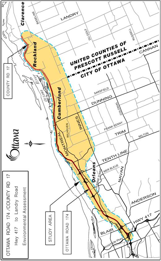
Extensive growth in Orleans, Cumberland and Rockland has increased traffic volumes on Ottawa Road 174/County Road 17 leading to congestion during peak periods. In addition, there are road safety concerns related to the numerous at-grade intersections, lower geometric design standards of the two-lane roadway as well as high traffic demand and the lack of passing opportunities, resulting in a poor level of service. Capacity, operational, and safety improvements may be required to address these deficiencies. The proposed study limits are shown in Figure 1.
Figure 1:
Ottawa Road 174/County Road 17 EA Study Limits
Widening of the Ottawa Road 174 from the Split to Jeanne D’Arc Boulevard is identified in the City’s Transportation Master Plan (TMP) as a Phase 2 project (2016-2022) with no plans for expansion beyond Jeanne D’Arc Boulevard eastwards within the City’s current planning horizon. This is consistent with the City’s Official Plan (OP) and TMP planning objectives of intensification, giving priority to public transit to increase transit modal split, and integrating transportation and land use. Furthermore, the City has a goal of achieving a future 41% transit modal split at the Green’s Creek screenline, which will require consideration of complementary transit objectives in this study such as the East Transitway extension from Place D’Orleans to Trim Road, identified in the City’s TMP. For this joint EA study, transit supportive initiatives will also be considered beyond the City limits and will include transit and carpooling in the County as part of the scope of work.
The City of Clarence-Rockland has identified in a previous transportation planning study a southern corridor around the Rockland urban area. This corridor is being protected in the City of Clarence-Rockland’s Official Plan. The EA Study Area includes the consideration of either the northern County Road 17 alignment or the southern corridor within the City of Clarence‑Rockland extending east and terminating in the vicinity of Landry Road connecting to County Road 17.
Key considerations for this EA study include the following:
· Detailed evaluation of future transportation demand for the County and City’s east-west direction of travel and public areas of interest;
· Transit objectives and integration;
· Corridor options;
· Context sensitive corridor design considering existing businesses and residential properties;
· Alternative modes of transportation; pedestrians, bicyclists, transit, and linkages from trips using Ottawa Road 174 and County Road 17;
· Coordination with concurrent studies and undertakings;
· Protection of the East Transitway corridor from Blair Station eastwards and ensuring adequate drainage;
· Effects of urban sprawl with improved capacity;
· Full evaluation of any potential impacts on significant natural environment areas and Species at Risk (SAR); and
· Effects on existing communities (Ottawa, Cumberland and Rockland).
Key deliverables for this EA study include the following:
- Study Design and Schedule Document;
- Parallel east and west Open Houses (in the City of Ottawa and the County/City of Clarence Rockland) to reflect the size of the Study Area;
- Technical specialist reports (land use, environmental, economic, engineering) to support the baseline of data used to select a Preferred Corridor and to provide confidence in the design and corridor protection of the Recommended Plan;
- Draft and final Environmental Study Report (ESR);
- Consultation report;
- Mitigation plan;
- Property requirement plan;
- Project Recommended Plan incorporating functional design drawings ((1:1000 scale, plan and profile) of the preferred design, and other information as detailed elsewhere in this document;
- A detailed written description of the undertaking including the design parameters;
- Roadway cross-section drawings for typical sections as well as at critical areas;
- Project Cost Estimate Report identifying the project baseline budget in Work Breakdown Structure (WBS) format divided in logical divisions including the geographic limits of the City of Ottawa and County.
ENVIRONMENTAL IMPLICATIONS
The study will examine and evaluate the project’s effects on social, cultural, physical, and natural environments within the study area. Appropriate mitigation measures will be developed and post mitigation environmental impacts will also be determined.
RURAL IMPLICATIONS
The study area lies within the urban and rural areas of the City and County. Potential impacts on the rural character, rural residents, and any active farming operations will be incorporated in the study. Traffic demand originating from existing and future residents of the rural areas in both the City and the County will also be incorporated into the study process.
CONSULTATION
Consultation with stakeholders, public agents, and individuals will be an integral component of the EA study. The consultation process will include meetings with key stakeholders through the Agency Consultation Group, Public Consultation Group, and Business Consultation Group. Consultation with the general public will occur principally through open houses and also through the project web page, e-mail, and additional meetings as required.
COMMENTS BY THE WARD COUNCILLOR(S)
Councillor Tierney has read the Ottawa Road 174/County Road 17 (Highway 417/Split to Rockland) Environmental Assessment – Statement of Work and is in agreement with the content as presented.
Councillor Bloess agrees with the report.
Councillor Monette has no concerns with this report.
Councillor Blais comments: Hwy 174 is a vitally important link for residents of Orléans and Cumberland. Movement on this file, which I wholeheartedly support, after decades of inaction is very good news for residents who want to spend more time with their families and less time in traffic and I look forward to the results.
LEGAL IMPLICATIONS:
There are no legal impediments to implementing the recommendation in this report.
RISK MANAGEMENT IMPLICATIONS
N/A
CITY STRATEGIC PLAN
The recommendation contained herein aims to support the City of Ottawa Strategy Map adopted by Council:
Transportation & Mobility
TM3 – Provide infrastructure to support mobility choices
ACCESSIBILITY IMPACT
For this EA study, any accessibility requirements will conform to the Accessibility for Ontarians with Disabilities Act.
FINANCIAL IMPLICATIONS
Consistent with a legal agreement between the County and Province, as well as with the direction of Ottawa City Council, this EA study is to be funded through the Province.
SUPPORTING DOCUMENTATION
Document 1: Statement of Work: Ottawa Road 174/ Prescott Russell County Road 17 Environmental Assessment Study
DISPOSITION
Following Committee approval of the attached Statement of Work, the County, in partnership with the City of Ottawa, will commence with a competitive procurement process in the selection of a consultant.
Furthermore, the City’s Legal Services will prepare a legal agreement with respect to the EA study between the City and the County.


INTRODUCTION
The United Counties of Prescott and Russell in partnership with the City of Ottawa are undertaking a multi-jurisdictional Class Environmental Assessment (EA) Schedule C Study for improvements to Ottawa Road 174 from the Highway 417/Ottawa Road 174 Interchange (the “Split”) to Canaan Road in the City of Ottawa, and improvements to Prescott Russell County Road 17 from Canaan Road to County Road 8 (Landry Road) in the United Counties of Prescott and Russell. The United Counties of Prescott and Russell will be the lead proponent as defined in the Class EA. This Statement of Work describes the intentions of Prescott and Russell (the “County”) and the City of Ottawa (the “City”) with respect to the methodology, public consultation and deliverables for this study.
PLANNING CONTEXT
Ottawa Road 174 and County Road 17 from east of the Highway 417 Split to east of Rockland was formerly Provincial Highway 17 and was transferred to the City and the County in the 1990s. In the City, the section from the Split to Tenth Line is a four-lane freeway with interchanges and full access control. Dedicated transit lanes in both directions of and within the Ottawa Road 174 road corridor extend eastwards from the Transitway east of Blair Station ending at Place D’Orleans station. East of Tenth Line, the road transitions to a four-lane arterial with a signalized intersection at Trim Road, and then continues as a two-lane undivided arterial to the east, passing through residential homes on both sides of Ottawa Road 174 with direct access to the roadway. From the City limit at Canaan Road easterly to east of Rockland, the road is under the jurisdiction of the County.
Owing to the natural geographic constraints of the Ottawa River and the Mer Bleue Bog, there are limited alternative east-west transportation routes in the east urban area to service transportation demand associated with existing and planned development in the City and the County. Alternative roads such as Old Montreal Road and Innes Road are not continuous through the study area from Ottawa to Rockland, and the Rockliffe Parkway is not designed as a high capacity arterial.
Extensive growth in Orleans, Cumberland and Rockland has increased traffic volumes on Ottawa Road 174/County Road 17 leading to congestion during peak periods. In addition, there are road safety concerns related to the numerous at-grade intersections, lower geometric design standards of the two-lane roadway as well as high traffic demand and the lack of passing opportunities, resulting in a poor level of service. Capacity, operational, and safety improvements may be required to address these deficiencies. The proposed study limits are shown in Figure 1.
Widening of the Ottawa Road 174 from the Split to Jeanne D’Arc Boulevard is identified in the City’s Transportation Master Plan (TMP) as a Phase 2 project (2016-2022) with no plans for expansion beyond Jeanne D’Arc Boulevard eastwards within the City’s current planning horizon. This is consistent with the City’s Official Plan (OP) and TMP planning objectives of intensification, giving priority to public transit to increase transit modal split, and integrating transportation and land use. Furthermore, the City has a goal of achieving a future 41% transit modal split at the Green’s Creek screenline, which will require consideration of complementary transit objectives in this study such as the East Transitway extension from Place D’Orleans to Trim Road, identified in the City’s TMP. For this joint EA study, transit supportive initiatives will also be considered beyond the City limits and will include transit and carpooling in the County as part of the scope of work.
The City of Clarence-Rockland has identified in a previous transportation planning study a southern corridor around the Rockland urban area. This corridor is being protected in the City of Clarence-Rockland’s Official Plan. The EA Study Area includes the consideration of either the northern County Road 17 alignment or the southern corridor within the City of Clarence-Rockland extending east and terminating in the vicinity of Landry Road connecting to CR17.
Key considerations for this EA study include the following:
· Detailed evaluation of future transportation demand for the County and City’s east-west direction of travel and public areas of interest
· Transit objectives and integration
· Corridor options
· Context sensitive corridor design considering existing businesses and residential properties
· Alternative modes of transportation; pedestrians, bicyclists, transit, and linkages from trips using Ottawa Road 174 and County Road 17
· Coordination with concurrent studies and undertakings
· Protection of the East Transitway corridor from Blair Station eastwards and ensuring adequate drainage
· Effects of urban sprawl with improved capacity
· Full evaluation of any potential impacts on significant natural environment areas and Species at Risk (SAR)
· Effects on existing communities (Ottawa, Cumberland and Rockland)
PROJECT SCOPE, TASKS, AND DELIVERABLES
1. General
The study will be consistent with the approach and requirements set out in the Provincial Environmental Assessment Act. An initial meeting with the Ministry of Environment (MOE) has confirmed the validity of the Municipal Class EA Schedule C for the multi- jurisdictional project. Federal EA requirements may also be triggered if federal lands, permits and approval, or funding are included with the project. All relevant environmental inventories and analysis undertaken for this assignment will be of sufficient scope to satisfy both Federal and Provincial EA requirements.
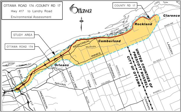
1.1 Study Area
The primary study area, shown in Figure 1, includes the linear Ottawa Road 174 corridor from the Split easterly to Trim Road. From the Trim Road crossing easterly the Study Area will allow consideration of alternative road solutions and alignments that will satisfy the Class EA as reasonable alternatives to reach the eastern Study Area limit at County Road 8, using either the existing corridor or the protected southern Rockland corridor. The study area may be adjusted as necessary in order to comprehensively identify the influences on, and the effects of the undertaking as options are developed.
Figure 1: Ottawa Road 174/County
Road 17 EA Study Limits
1.2 Timing
Project scoping is ongoing. A Request for Quotation (RFQ) and Request for Proposal (RFP) process will be undertaken with award of the EA study anticipated in spring, 2012. The EA study is expected to be completed in approximately 2 years.
1.3 Coordination with Concurrent Studies
The EA Study process will take into consideration any information including analysis and preliminary findings of concurrent ongoing transportation, development and infrastructure projects that could influence the direction and/or conclusions of the Study. These projects include:
- Current development applications and associated studies (i.e. transportation impact studies);
- Interprovincial Crossings Phase 2B Study by National Capital Commission (NCC) with proposed corridor linking to Ottawa Road 174;
- Highway 417 widening by MTO west of the Split in response to the proposed Ottawa Light Rail Transit (OLRT) project;
- Infrastructure projects including the Orleans Watermain;
- OLRT construction staging plan;
- Ottawa Road 174/Trim Road intersection improvements;
- Trim Road Widening;
- East Transitway Extension Place D’Orleans Station to Trim Road Feasibility Study;
- Ottawa Road 174 In-Service Safety Review;
- Hospital Link and Cumberland Transitway Westerly Connection to Blair Station;
- Innes-Walkley-Hunt Club Connection; and
- NCC Greenbelt Master Plan.
1.4 Background Material
Relevant background material will be collected and reviewed. This includes:
- City of Ottawa and County policies/guidelines/practices;
- Land Use Planning principles (Ottawa, Cumberland Village and Clarence-Rockland);
- Travel surveys and traffic counts including travel demand forecasts and origin/destination data;
- Population, employment and development projections;
- Current and past development applications and associated studies (e.g. traffic and noise);
- Property ownership (and tenants), easements and rights-of-way information;
- Natural environment studies;
- Relevant economic development studies;
- Relevant water, wastewater and storm water management studies;
- Relevant stream crossing information (fisheries, water quality, etc.);
- Arterial Road Corridor Design Guidelines;
- Pedestrian and Cycling plans;
- Current and planned transit opportunities;
- Potential High Occupancy Vehicle or carpooling initiatives; and
- Transit integration plans east of the City of Ottawa.
1.5 Summary of Deliverables
The deliverables for the study will include:
- Study Design and Schedule Document;
- Presentation materials (bilingual) for Agency, Public, and Business Consultation Group meetings and Public Open Houses;
- Parallel east and west Open Houses (in the City of Ottawa and the County/City of Clarence Rockland) to reflect the size of the Study Area;
- Public Open House Summary Reports;
- Project Update Newsletters;
- Information (bilingual text and graphics) for Study Web Page;
- Linkage from the City of Ottawa’s web site to the Study website;
- Technical specialist reports (land use, environmental, economic, engineering) to support the baseline of data used to select a Preferred Corridor and to provide confidence in the design and corridor protection of the Recommended Plan;
- Draft and final Environmental Study Report (ESR);
- Project Recommended Plan incorporating functional design drawings of the preferred design, and other information as detailed elsewhere in this document;
- Approvals in principle for storm water management facilities, grade separations, etc;
- Approvals in principle for federal fisheries mitigation or compensation approaches; and
- Project Cost Estimate Report identifying the project baseline budget in Work Breakdown Structure (WBS) format divided in logical divisions including the geographic limits of the City of Ottawa and County. The project estimate will be sufficiently accurate for budgetary purposes and for funding applications, as appropriate.
2. Study Design
Draft and Final Study Design reports will be developed to ensure that all aspects of the EA will be addressed. Part of this task will be to liaise with the Provincial and Federal authorities responsible for EA reviews to obtain their input on EA requirements specific to this project. The Study Design will:
- Confirm the study area;
- Identify Alternative Planning Solutions (This study extends beyond the limits of the City of Ottawa and those solutions considered within the City of Ottawa’s TMP);
- Identify the various disciplines required to undertake the EA with expertise in areas such as:
o Transportation planning and design;
o Urban, suburban, and rural land use planning;
o Road safety assessment;
o Natural environment;
o Drainage and storm water management;
o Fluvial geomorphology
o Geotechnical;
o Foundations;
o Social environment;
o Business impacts;
o Municipal/Utilities;
o Noise;
o Vibration;
o Structural;
o Air quality and global warming;
o Archaeology;
o Heritage; and
o Landscape architecture.
- Describe the major tasks of the EA, including a plan for development of alternative corridors and alignments as well as a process for the evaluation of the alternatives;
- Define a detailed evaluation methodology to rate and rank alternatives that allows for sensitivity testing of alternative values;
- Include a detailed public consultation program (with bilingual Public Open Houses and presentations) identifying the roles and responsibilities of the Study Consultation Groups, as well as timelines and communication plans for the Public Open Houses;
- Highlight major milestones and decision points; and
- Define public consultation opportunities with the public and business consultation groups and Public Open Houses.
2.1 Identify a List of Stakeholders
This study will involve a number of stakeholders, including community groups, property owners, businesses, approval agencies and special interest groups. Early in the study process, stakeholders will be identified. This will be accomplished through various forms of consultation, including liaison with Ward Councillors in both the Cities and County.
2.2 Consultation Program
This study will examine a wide range of technical, social and environmental issues and will incorporate a broad number of community and business interests. The success of this effort is contingent on an effective and timely consultation program.
The consultation process will include meetings with key stakeholders as well as an Agency Consultation Group (ACG), a Public Consultation Group (PCG), and a Business Consultation Group (BCG). The membership, roles and responsibilities of these groups will be refined through the Study Design, and include a general invitation to all City of Ottawa Advisory Committees.
Consultation with the general public will occur principally through Public Open Houses, but also through meetings with affected interest groups, the project web page and by e-mail. Additional meetings with specific agencies, groups or individual property owners will be held as required in order to address any particular issues as they may arise. Any accessibility requirements during the consultation process will be provided in accordance with the Accessibility for Ontarians with Disabilities Act.
A Study Web Site has been established by the United Counties of Prescott and Russell: Road to Rockland.com, which will have links from the City of Ottawa, City of Clarence-Rockland and United Counties web sites.
3. Environmental Assessment
The undertaking of the Environmental Assessment comprises the following tasks outlined below:
3.1 Project Need
The Class EA work begins with the review of the need and justification for safety and capacity improvements to Ottawa Road 174/County Road 17 from the Split to east of Rockland. This exercise will be carried out by forecasting travel demand, and determining both existing and future needs for a facility with respect to the impact on east-west travel demand/distribution, economic benefits and links to major employment destinations. In addition, the study will conduct a collision and roadside safety analysis to identify current and projected transportation operational problems and opportunities within the study area.
3.2 Existing Conditions
An inventory of the social, economic (agricultural, recreational, employment, retail etc.), physical and natural environments within the study area will be compiled. The inventory will consider all available background material and where necessary, supplement this information through on-site surveys and/or detailed studies. The inventory must be of sufficient detail to enable the analysis and evaluation of alternative transportation solutions, designs and mitigating measures.
In general, the inventory will identify and describe those aspects of the environment that could potentially affect, or be affected by the undertaking. Some of the specific aspects of the environment associated with this project include but is not limited to:
- Adjacent private property and neighbouring communities;
- Effects on green spaces and natural areas;
- Effects of loss of bypass traffic to businesses;
- Current and future cycling and recreational pathway corridors/routes;
- Potential influence of the project from/on development patterns in Ottawa, Cumberland and Rockland;
- Current storm water drainage patterns;
- Subsurface (geotechnical) conditions and stability of sensitive slopes;
- Heritage and archaeological conditions;
- Utilities including water, sanitary, hydro, gas, cable, phone, fibre optic, etc;
- Air quality, noise and vibration;
- Species at risk; and
- Aesthetics – views and vistas.
The existing conditions must be completed for the entire study area so that as alternative solutions and designs are developed and analyzed, the cumulative effects can be examined. It must also be broad enough to fulfill both Provincial and Federal EA requirements.
3.3 Alternative Solutions
The Study will identify and examine all reasonable alternatives for improvements to Ottawa Road 174/County Road 17 from the Split to east of Rockland.
The key components of this stage include:
- Identify alternative solutions to address transportation problems including:
o Do nothing;
o Expand and enhance public transit service;
o Expand and enhance cycling routes;
o Implement transportation demand management (TDM) measures to reduce travel demand;
o Expand other arterial roadways in the east-west direction; and
o Expand the existing Ottawa Road 174/County Road 17 roadway.
- Develop evaluation criteria and indicators to assess the impacts (with consideration to possible mitigation measures) on the environment by the various solutions; and
- Analyze and evaluate the alternative solutions and select the preferred solution(s).
The different alternative solutions and designs will be developed with input from the Consultation Groups and will be presented to the public for comments at several Public Open Houses throughout the study.
The travel-forecasting component included in this stage of the EA must:
- Identify the needs for all modes of transportation including walking, cycling, transit, automobile and commercial goods movement;
- Incorporate the principles (e.g. mode share targets etc.) of the current County and City of Ottawa OP’s and TMP’s in balancing demand to capacity while promoting the desire to increase transit use, and appropriate land uses; and
- Provide supporting analysis and a business case of the societal benefits of improvements and recommendations for the staging of construction and alternative or supporting infrastructure.
3.4 Design Alternatives
The study will identify and evaluate various design alternatives (alternative corridors and alignments/cross sections within those corridors) for the selected solution. Alignment and cross‑section design alternatives will be identified based on consideration of constraints within the study area, and input from the public, approval agencies and landowners, as well as City of Ottawa and County guidelines/standards/practices. All proposed designs will include any required modifications on connecting roadways (public or private).
3.5 Evaluation Criteria and Evaluation Process
A comprehensive methodology utilizing measurable evaluation criteria will be developed to evaluate the various alternative designs. The evaluation process will be clearly described and documented and allow a defendable measurable of the differences between alternatives that include mitigation. Several levels of evaluation will be undertaken of the design alternatives to ensure local design alternatives are considered and defended before comparing alternative alignments or corridors. The evaluation methodology will be capable of sensitivity testing to consider alternative values.
3.6 Impact Assessment
The effects of each alternative design on the environment will be thoroughly evaluated. Mitigation measures and associated implications (e.g. cost of mitigation etc.) are to be identified and considered in the evaluation process. The study must clearly identify the initial impacts of each alternative as well as the net post-mitigation effect using quantifiable indicators and measures wherever possible.
Effects on traffic operations will be evaluated in accordance with current City of Ottawa, County, Transportation Association of Canada (TAC) or MTO guidelines and practices. To ensure that all impacts are appropriately evaluated, detailed analysis will be required for certain issues such as:
- Freeway transition treatment
- Interchange operations
- Safety of bus operations and potential High Occupancy Vehicle lanes
- Highway signage
Other impact assessments will include:
- Air quality
- Lighting and light spillover
- Archaeology and heritage
- Visual impact on existing homes
- Noise/Vibration
- Roadway drainage and storm water management
- Subsurface conditions, geotechnical and utilities
- Vegetation, terrestrial
habitat and aquatic habitat
- Species at Risk
3.7 Costing
An accurate project baseline budget will be developed to allow the County and City of Ottawa’s short and long range capital budget forecasting, priority setting, and development charges strategy or application for funding from upper tier governments. The baseline budget will be developed using a Work Breakdown Structure (WBS) format in current dollars, including parametric estimating information from the City of Ottawa and MTO for similar projects, and include contingency allowances.
Project costing is a fundamental criterion in the evaluation of alternatives and will be a key consideration in the analysis of staging considerations and to establish implementation strategies.
3.8 Recommended Plan
Following the evaluation of alternatives, independent technical reviews and determining all necessary mitigation measures to minimize any adverse impacts of the project, a recommended plan will be developed. This will include:
- A detailed written description of the undertaking including the design parameters;
- Functional design drawings (1:1000 scale, plan and profile) for the preferred alignment with a geo-referenced horizontal alignment, vertical profile, grading, drainage and property envelope;
- Roadway cross-section drawings for typical sections as well as at critical areas;
- Preliminary General Arrangement drawings of structures, significant retaining walls and noise barriers;
- Geotechnical study recommendations dealing with slope stability of sensitive soils;
- Freeway transition treatment and roadside safety audit;
- Lighting and signage plans;
- Mitigation measures to reduce the environmental impacts of the project;
- Landscape design plan;
- Bicycle network plan;
- Property request plan;
- Stormwater management and roadway drainage plan;
- Utility relocation Plan;
- Detour plans;
- Infrastructure implementation/staging plan (e.g. watermains, sewers etc.);
- Implementation (phasing) plan; and
- Itemized construction cost estimate.
The recommended plan will clearly identify and set out the requirements and timing for all subsequent approvals required to proceed with the construction phase of the project. The recommended plan will be presented to the City of Ottawa Transportation Committee and Council, City of Clarence-Rockland Council and United Counties of Prescott and Russell Council for approval.
3.9 Environmental Study Report
An Environmental Study Report (ESR) will be prepared to document the entire study process including the approved design, mitigation measures, and consultation efforts. The ESR will be placed on public record for a minimum 30-day review period as per the Environmental Assessment Act.
4. Consultation
Consultation with public agencies, private groups, City of Ottawa Advisory Committees and individuals is an integral component of this Study. The consultation process will include meetings with key stakeholders through an Agency Consultation Group (ACG), a Public Consultation Group (PCG), a Business Consultation Group (BCG), and the general public through Public Open Houses. A minimum of three meetings with each Consultation Group will be held during the course of the study. Representation on the ACG, PCG, and BCG will be confirmed during the development of the Study Design and in consultation with Ward Councillors.
4.1 Agency Consultation Group
An Agency Consultation Group (ACG) will be formed to provide input on planning, engineering and environmental issues and will provide general guidance to the Study Team. ACG members will include experts in their related fields from government agencies and approval bodies including, but not limited to:
Province of Ontario
- Ministry of Transportation of Ontario
- Ministry of the Environment
- Ministry of Natural Resources
- Rideau Valley Conservation Authority
Federal
- National Capital Commission
- Department of Fisheries and Oceans
- Transport Canada
United Counties of Prescott Russell
· Planning and Economic Development Department
· Public Works
City of Ottawa
- Public Works Department
- Infrastructure Services Department
- Planning and Growth Management Department
- Transit Services Department
- Environmental Services Department
- Emergency and Protective Services Department
- Realty Services Branch
- Police Services
City of Clarence
Rockland
· Planning Department
· Physical Services Department
4.2 Public Consultation Group
A Public Consultation Group (PCG) will be formed to enable private groups to provide direct input to the study, advising and commenting on local issues and concerns. PCG members may include representatives from local community groups, special interest groups, and adjacent property owners. Membership of this group will be determined in consultation with affected Ward Councillors in the Cities of Ottawa and Clarence-Rockland.
4.3 Business Consultation Group
A Business Consultation Group (BCG) will be formed to enable business representatives to provide direct input to the study, advising and commenting on local issues and concerns. This group will reflect interests from both the City of Ottawa and City of Clarence-Rockland business areas.
4.4 Notifications
The public will be notified at appropriate stages in the Study pursuant to the Environmental Assessment Act. Each announcement will take the following forms:
- Advertisements in daily newspapers (The Ottawa Citizen, Le Droit, and Journal Vision);
- Advertisements in community papers where appropriate; and
- The project web site.
4.5 Public
Open Houses
The Public Open Houses (POHs) will be held to present
and obtain feedback on Alternative Planning Solutions, environmental
inventories of existing conditions, alternative design concepts, the analysis
and evaluation, Technically Preferred Alternative and the final Recommended Plan
including mitigation measures. The EA
assignment will include three rounds of bilingual POH meetings that include a
formal presentation and question and answer period at each POH. The POHs will be advertised in daily and
local newspapers and notification will be e-mailed to persons on the Project’s
Master Mailing List.
Background and presentation material will include a
Project Update Newsletter which will summarize the information presented at the
POH and will be available for general distribution. All material presented at the POH meetings as
well as the Project Update Newsletter will be bilingual. Bilingual staff will be present during all
Public Open House meetings. A summary report will be produced to document each POH including all comments received.
4.6 Project Master Mailing List
A Master Mailing List will be prepared and updated via Public Open Houses, general enquiries, e-mails and other forms of consultation.
4.7 Project Web Page
A Project Information Web Page (RoadtoRockland.com) for the Study will be maintained with links from the Cities and County web sites to inform the public of the progress of the study and upcoming meetings or activities, post the bilingual materials presented at each Open House, and provide a point of contact for e-mail correspondence.
4.8 Frequently Asked Questions
To assist in providing information to the public, a Frequently Asked Questions (FAQ) document will be prepared to provide answers to common questions raised during the study. The FAQ document will be established early in the study process and will be updated regularly. It will also be posted on the web site.
5.0 First Nation Consultation
Aboriginal interests will be considered through direct communication with aboriginal communities and through Provincial and Federal agencies to comply with requirements of EA for consultation and accommodation with Aboriginal groups. These communities and agencies will be contacted and requested to identify any potential interest and to confirm their participation in the consultation process. The Aboriginal Consultation Plan will be cooperatively developed during the EA study with any potentially affected Aboriginal groups that wish to participate in the EA study process. The Aboriginal Consultation Plan may extend beyond what would ordinarily be required under the Provincial EA legislation as a result of consultation obligations confirmed by recent court cases.