Report to/Rapport au:
Transportation and Transit
Committee/
Comité des transports et des
services de transport en commun
and Council / et au Conseil
01 February 2003 / le 01
février 2003
Submitted by/Soumis par: Ned
Lathrop, General Manager/Directeur général
Development Services Department
/ Services d’aménagement
Contact/Personne-ressource:
Vivi Chi, Manager, Transportation Infrastructure
Gestionnaire, Infrastructure
des transports
580-2424, ext. 21877, vivi.chi@ottawa.ca
|
Ref N°: ACS2003-DEV-POL-0010 |
SUBJECT: RAPID TRANSIT EXPANSION STUDY –
RECOMMENDATIONS
OBJET: ÉTUDE SUR L’EXPANSION DU RESEAU DE TRANSPORT EN COMMUN
RAPIDE - RECOMMANDATIONS
REPORT
RECOMMENDATIONS
That the
Transportation and Transit Committee recommend Council approve:
1.
The recommended Rapid Transit
Network, which will form the basis for the transit component of the
Transportation Master Plan.
2.
The Rapid Transit Priority Plan,
pending clarification on funding sources.
3.
The direction to staff to develop an
Implementation Strategy that would include timelines, funding and partnership
options, and financial implications.
RECOMMANDATIONS
DU RAPPORT
Que le Comité des transports
et des services de transport en commun recommande au Conseil d’approuver :
1. le
réseau de transport en commun rapide recommandé, qui constitue l’assise du
volet du transport en commun dans le Plan directeur des transports;
2.
le programme prioritaire de transport en
commun rapide, les précisions sur les sources de financement étant à venir;
3.
la directive voulant que le personnel
œuvre à l’élaboration d’une stratégie de mise en œuvre comprenant les
échéanciers, les options de partenariat et de financement ainsi que les
répercussions financières.
BACKGROUND
Ottawa is one of the most
desirable cities in Canada in which to live and do business, and it is also one
of the fastest growing. Over the past 20
years the city’s population has increased by 41.6%. There is no doubt that this
growth has led to significant economic development, but the city is required to
fund over 80% of the costs associated with that growth while receiving less
than 10% of the new tax revenues generated by that growth. This presents significant challenges to
managing growth in the future. Ottawa’s attractiveness as an innovative and
competitive city depends upon its ability to sustain growth without damaging
its exceptional quality of life. Reliable and efficient public transit will become even more critical to our success.
As was noted in the Long-Range Financial Plan: First Steps (October
2002):
“American and European governments have recognized the critical role transportation infrastructure plays in serving as the backbone of every large city’s economy. Transportation infrastructure is a considerable expense for government, but it pays off in both ease of commercial activity and development of a high quality of life that attracts businesses and residents.”
The City of Ottawa currently has over 950 transit vehicles, 151 routes, and 46km of rapid transit service (in exclusive rights-of-way and shoulder lanes) delivering approximately 87 million trips in 2002. Ridership has increased by 25% over the past 6 years. This increase in public transit ridership has been achieved inside a challenging environment. Ottawa has not received continual public transit infrastructure funding from the Province of Ontario since the mid 1990’s, and Canada is the only G8 country without a national urban transit investment fund. As a result, although the bus transitway had bold beginnings, an ageing fleet and inability to fund expansion to new areas of growth now hamper its success.
Changing the way the city develops is one way to maximize the city’s
investment in the infrastructure needed to promote economic growth. Critical to
building a more sustainable city is investing in high quality transit, which in
turn reduces or defers the need to build more roads. This alternative provides
significant side benefits, such as less air and water pollution, more
compact and efficient development, and
creation of high quality community living.
In addition, as a
Partner for Climate Protection (a greenhouse gas reduction campaign set up by
the Federation of Canadian Municipalities), Ottawa has made a public commitment
to reduce greenhouse gas emissions. In support of this program and the Kyoto
Protocol, the new Official Plan commits to reducing
greenhouse gas emissions (and air pollution):
“Providing Infrastructure – A transportation system that emphasizes
transit, walking and cycling will be built to complement a compact city, where
a mix of uses are located within walking and cycling distance of each other and
the need to travel is reduced. In a compact city, people and activities are
located along rapid-transit corridors and in areas that can be serviced with
quality transit, creating a built-in ridership for transit and reducing the
need for car travel. Other infrastructure, such as water and sewage facilities,
is provided in a way that reinforces the City’s commitment to a compact city
and building safe and healthy communities.”
If implemented, the OP policies will lead to a reduction in energy use,
especially the burning of fossil fuels in the transportation system. An
important leg of this commitment is increasing transit usage, which in the long
term will decrease overall infrastructure costs.
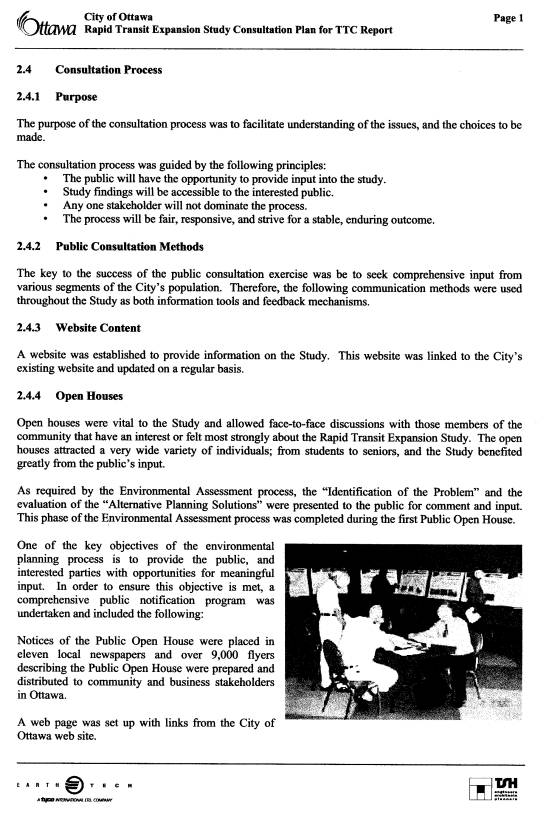
Progress to date
The
City’s Transportation and Transit Committee is an active partner in building a
vision for Ottawa in 2020. At its 17 October 2001 meeting, the Committee
reviewed a transit strategy that supports the city’s vision for a competitive
international city that successfully balances business, development and
liveability. The strategy outlined the steps required to meet these goals and
signalled the beginning of the Transportation Master Plan (TMP) updating process.
Progress to date includes:
n
November
2001: Committee approved the statement of work for the Rapid Transit Expansion
Study (RTES).
n
February
2002: A consultant team began work on RTES.
n
June
20, 2002: First public consultation open house.
n
December
4, 2002: A presentation to Committee on rapid transit corridor options.
n
December
2002: Second series of public consultation open houses.
n
February
2003: The study is nearing completion. This report presents the key results.
RTES Study Facts
Purpose: The purpose of RTES is to develop
a strategic plan for rapid transit, taking into consideration region-wide
growth projections. The study provides the rapid transit component of the
Transportation Master Plan (TMP) and both supports and is supported by the
guiding principles of the draft Official Plan (OP). The study is conducted
within the provincial and federal Environmental Assessment framework so that it
contributes to the need and justification components of any subsequent
environmental assessments.
Funding: RTES is funded in part by
Transport Canada and the Green Municipal Funds (a partnership of the Government
of Canada and the Federation of Canadian Municipalities), and by the Province
of Ontario through the Transit Investment Partnership (TIP) program.
RTES Assumptions
Population and Employment
Growth: The OP, TMP and RTES share the same projected population and employment
levels and distributions for the year 2021. These include that the city’s
population could increase by 50% in the next 20 years, from 800,000 to
1,200,000. The number of jobs in the city could increase from 500,000 to
750,000. Where people live and work are the primary factors in determining
travel needs. The number of homes and jobs with convenient access to the rapid
transit system is critical to its use.
Transit Ridership: RTES assumes that
transit travel would double from about 15% to about 30%. Given the increase in
population, this means that the number of transit trips would triple from 87
million to 260 million annually over the next 20 years.
RTES Recommendation
RTES recommends a future rapid transit network
for Ottawa, identifies appropriate technology within specific corridors and
proposes an action plan for those transportation corridors.
DISCUSSION
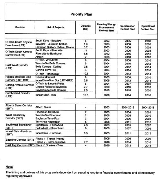
The recommended Rapid Transit Network and
Priority Plan are shown in Documents 1 and 2, respectively.
The Definition and Role of
Rapid Transit
OC Transpo services consist of a number of
components including buses in mixed traffic, buses operating on the transitway
(exclusive right-of-way), the O-Train, and Para Transpo. For purposes of this
study, rapid transit is defined as a convenient, fast
and frequent public transportation service that features a high carrying
capacity. Rapid transit operates on its own right-of-way, as a separate system
or in its own lane in shared corridors, and is given traffic signal priority
when crossing general traffic. It has stations that are well integrated with
adjacent development and with the surrounding transportation network to
maximize accessibility.
In the study, three generic rapid
transit technologies were identified as applicable to the Ottawa situation:
- Bus
Rapid Transit (BRT) - A frequent, limited-stop bus service operating in an exclusive
right-of-way or with priority in traffic. Buses can enter and leave the
rapid transit system and operate as a seamless feeder-bus local service.
The Ottawa Transitway is a prime example. The cities of Rouen and Nancy
(France) also have BRT service.
- Light
Rail Transit (LRT) - A ‘light’ rail vehicle providing frequent, limited-stop service
usually with exclusive right of way, sometimes with priority in traffic.
This system can be integrated with local feeder bus service. Examples
include Portland, Oregon and Calgary, Alberta.
- Light
Rail Vehicle on Existing Tracks - A rail vehicle capable of sharing track
with freight service. Frequent, limited-stop service. The current O-Train
is an example.
The rapid transit system will be key to
attracting and serving the increased ridership target. The recommended rapid
transit network has been developed to provide extensive high-quality service to
as broad an area as possible, and to serve significant employment nodes. To
achieve its goals, the rapid transit network must be complemented by land use
and operational policies that support transit use and discourage unnecessary
use of the single-occupant automobile.
Study Structure and Process
The study team was lead by a
consultant assisted by staff. An Advisory Committee comprised of senior staff,
three councillors, and public and stakeholder representatives provided overall
direction. A Technical Committee comprised of staff from municipal, provincial
and federal jurisdictions provided technical guidance. A Sounding Board
comprised of public and stakeholder representatives and individuals provided
general input and comment. Consultation was also augmented with a series of
open houses and the use of a project web site.
The study was undertaken in phases, with each
phase building on earlier work. Land use forecasts were used to identify the
strongest travel demand patterns for future rapid transit and to ensure that
the system responds to customer needs. Forecasted travel demand patterns are
shown in Document 3.
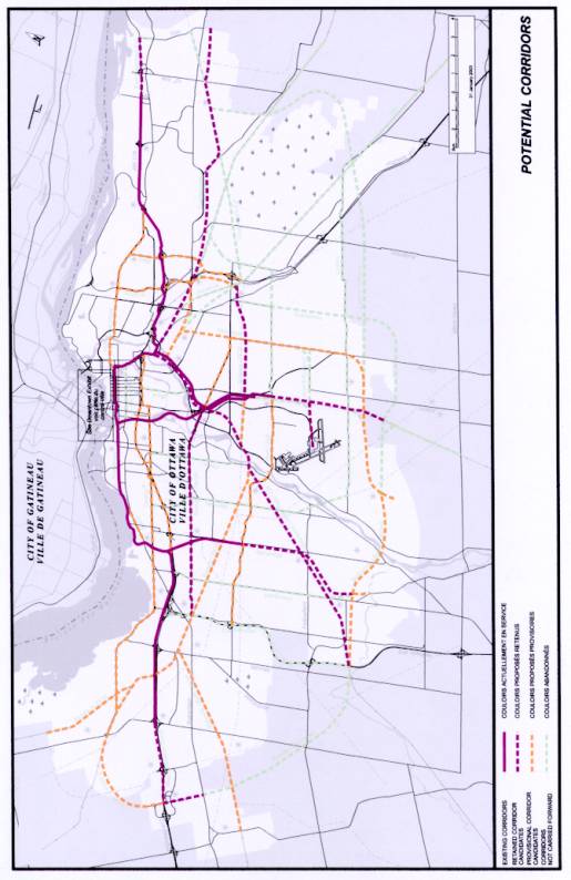
Potential rapid transit corridors were
identified from previous transportation plans, stakeholder and public
consultation, and field observations. These are shown in Document 4.
The strongest travel demand patterns were
matched with potential rapid transit corridors in a screening process to
determine best fit. The most promising corridors were combined into rapid
transit networks and matched with suitable technology. Five network options
were developed and assessed. The options varied in use of technology, extent of
network and corridors used. They all contained a core of common elements.
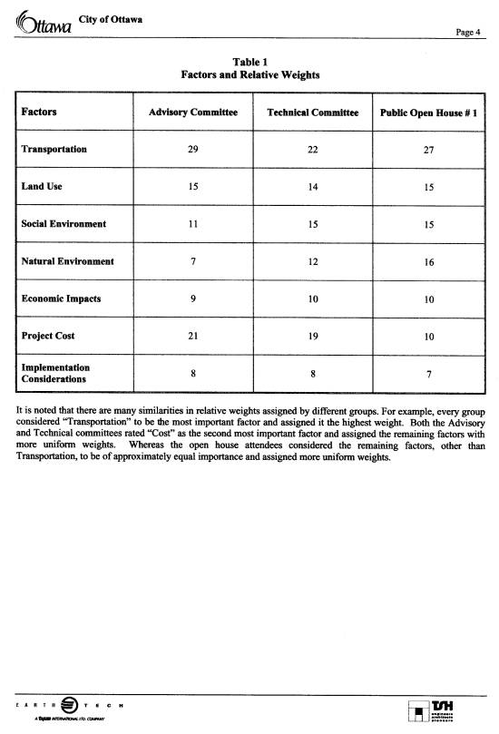
The networks were evaluated using factors
reflective of the 2020 Charting A Course
principles (see Document 5 for details) to formulate a ‘preferred’
network concept, which was taken to the December open houses for public
consultation.
Based on public and stakeholder
input, the preferred network was refined and resulted in the recommended Rapid
Transit Network (Document 1). Each segment of each corridor was then evaluated
against 10 criteria to rank the various options for implementation. (See the
Priority Plan for implementation in Document 2).
Key Study Findings and Conclusions
Recommended Rapid Transit Network
The recommended Rapid Transit Network is a
fusion of public values, technical analysis and the
feasibility of future partnerships. The network provides broad coverage
using a combination of Transitway bus rapid transit on existing corridors and
new system light rail transit for emerging corridors.
The network shows the expansion of
the O-Train corridor to downtown. It’s envisaged that a ‘lighter’, more
flexible LRT vehicle (as compared to the current O-Train technology) would be
selected to operate in the downtown setting. An electric-powered, low-floor
vehicle is recommended. Downtown service would be at-grade on an east-west
street (possibly on Queen Street or Sparks Street depending on the outcome of
an environmental assessment study). The O-Train corridor would extend
southwards to the Riverside South community and eventually across the Rideau
River to the Barrhaven area.
New rapid transit corridors using light rail
transit would radiate from the downtown via Carling Avenue and Montreal Road.
Light rail vehicles would operate in semi-exclusive rights-of-way. These
corridors are seen as having strong potential for smart growth redevelopment
when appropriate land-use policies and initiatives support the light rail
service. The Montreal Road corridor would serve the National Research Council
Campus and extend along Blair Road to Innes Road to connect with the Cumberland
Rapid Transit corridor. The new Carling Avenue corridor would connect the
O-Train corridor to both the Southwest and West Transitways.
An east-west LRT line between Cumberland and
Kanata would operate south of the core area, connecting business parks and residential
areas along the route and providing transit transfer opportunities at the
O-Train corridor and the Southeast and Southwest Transitways.
In the longer term, a BRT corridor is proposed
between Innes/Blair Road and the Southeast Transitway to serve the hospital
area.
The
downtown transitway on Albert and Slater Streets would be upgraded to increase
its capacity. Passenger-friendly amenities such as enhanced waiting areas and
improved service information (e.g. electronic notice board) would be provided,
along with a stronger visual identity. As applications for redevelopment are
received, the City can work in partnership with the applicants to identify
opportunities for upgrading the integration of the transit facility with
adjacent buildings.
The Transitway system would
also be extended south on Woodroffe Avenue to Barrhaven, east along
Highway 174 to Orleans, and west to Kanata. The West Transitway would be
upgraded between Bayshore and Pinecrest to improve operations in that section.
Upgraded bus transit service would be developed in the Baseline/Heron corridor
to improve cross-town connectivity in two stages. In the first stage, transit
priority measures would be implemented early. In the second stage, a
semi-exclusive right-of-way strategy would be implemented to upgrade this
important corridor.
Overall, the rapid transit network includes
approximately 114 km of double tracks for electrified light rail, 42 km of
transitway extension and 58 new stations.
This could be implemented over a 20-year timeframe, and represents
approximately five times the extent of the existing system. The rapid transit
network would also require in the order of 110 LRT vehicles, 70 articulated
buses and garage/maintenance and transit control facilities by 2021.
If the recommended Rapid Transit Network were
not implemented, a significant amount of additional road capacity would be
required – about 20 lanes of arterial roadway leading into the central city
core and about 200 more lane-kilometres city-wide. The significant adverse
community, environmental and social impact of this would be untenable and
contrary to the city’s smart growth objectives.
To provide a similar level of service by
conventional bus service within mixed traffic (i.e. improving local transit
service with no further expansion of the rapid transit network), the City would
require a fleet of over 500 articulated buses at a cost of approximately $400
million. These would have only half the life cycle of LRT vehicles.
The recommended Rapid Transit Network is shown
in Document 1.
Development of the Priority Plan
To develop the priorities for implementation,
the network was divided into segments to ease the comparative assessment.
Criteria for the evaluation of each segment included the 10 criteria described
in the following table:
|
Criteria Group |
Criteria |
Criteria Definition |
|
Keeping the Economy Going |
|
Enhancing the level of service for those already having access to rapid transit. |
|
Providing rapid transit service to delay or avoid the need for road construction. |
|
|
Population and/or employment growth is expected to be significant in the short term. |
|
|
Getting it Done |
|
The extent to which previous planning has been undertaken (i.e. Official Plans, secondary plans, environmental assessment approvals, property protection). |
|
The ease with which engineering and construction can proceed from a purely technical point of view. |
|
|
Shaping the City |
|
The extent to which the corridor implementation supports Smart Growth objectives of intensification and redevelopment. |
|
Enhancing access to rapid transit service for
existing communities. |
|
|
Introducing rapid transit early as new communities develop in order to shape travel habits to use transit. |
|
|
Ability of the corridor to be implemented in stages or within a variable timeframe. |
|
|
The extent to which congestion of the downtown is eased or transit trips are able to bypass the downtown area or new downtown capacity is provided. |
For
comparative analysis, the segment scores were multiplied by a weighting given
to each criterion, and the totals added to represent the relative ranking of
the segment. The criteria were weighted in four different ways. Initially, all
criteria were given equal weighting; then the criteria were combined into three
thematic groups; then the group ratings were adjusted to reflect varied
emphasis on ‘Keeping the Economy Going’ or ‘Shaping the City’. It is
significant to note that regardless of the weighting scenarios, the relative
priorities remained constant.
To develop an action plan, the following
implementation strategies were adopted:
- recognize
a strong community preference for rail
- utilize
LRT for new rapid transit corridors
- continue
with upgrading and expansion of BRT for existing corridors
Building upon the success of the O-Train pilot
project, the first priority is to expand the LRT service into the downtown to
the Rideau Centre, as well as extending south to the developing Riverside South
community. From the Rideau Centre, the LRT service can continue eastward along
Montreal Road to the Cumberland corridor.
Upgrades to the transitway can be
implemented on an ongoing basis on Albert/Slater Streets, the West Transitway
and the Woodroffe corridor. Upgrades would assume expansion of and enhancements
to the current bus fleet to increase the quality of transit service
commensurate with the expected growth in transit travel demand on the existing
system.
Subsequent priorities include
extensions of the system into developing areas and provision of a new east-west
service bypassing the downtown and serving south industrial parks.
While
this report focuses on the expansion of the rapid transit component of the
public transit system, the OP and TMP objective of increasing overall ridership
to 30% share of travel will require expansion of the transit bus fleet and supporting
facilities. There is a continual need to modernize and expand the fleet and
garage facilities, to improve passenger amenities and fare collection systems,
and to expand park-and-ride facilities.
A table of recommended improvement priorities
is included in Document 2.
Supporting Policies
One of
the major goals of the Official Plan is to create a city that relies more on
public transportation - changing people’s current travel behaviour to support
sustainable transportation choices. Policy areas that support rapid transit
ridership fall into four categories:
Land
Use
- Locate employment-related
high-density development nodes at transit stations
- Work
with federal agencies to maintain its concentration of employment in the
central area and at key rapid transit nodes
System
Integration
- Provide adequate Park-and-Ride
lots at strategic locations
- Provide
for communication with Quebec jurisdictions to achieve convenient transit
connectivity across the Ottawa River
Quality of Service
- Expand
the rapid transit system into developing areas to serve users with faster
service, thereby establishing transit ridership patterns early
- Secure
sustained funding for the ongoing maintenance of the existing system and
delivery of additional extensions
Demand
Management
- Emphasize reduced travel demand
instead of increasing road capacity
- Develop a parking strategy
consistent with transit objectives
These policies are interdependent and their
synergies achieve the desired change in travel behaviour. The overall success
of the policies can be measured in increased ridership on a per capita basis
and on the increased share of transit usage relative to auto use.
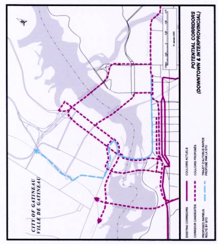
Interprovincial Transit
RTES identified the potential for
interprovincial transit corridors at three locations – the Prince of Wales
Bridge corridor, the Chaudière/Portage Bridge corridor and the
Alexandra/Macdonald-Cartier Bridge corridor. It was concluded that a detailed
study is required to assess these and other interprovincial transit corridors
and their impacts on the downtown Ottawa and Gatineau, including consequences
on King Edward Avenue. The statement of work for this separate study, with a
structure and process under the joint direction of the City of Ottawa, City of
Gatineau and the National Capital Commission, is currently being prepared. The
statement of work will be presented to Committee for approval in the near
future before study initiation.
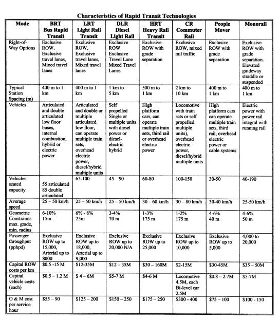
Comparing Bus and Rail Technologies
Based on
review of existing transit operating systems, it is generally accepted within
the rapid transit industry that the relative capacities of BRT and LRT are
comparable, with LRT having a greater capacity (up to 30%).
The right-of-way requirements for BRT and LRT
are comparable.
The
capital costs for LRT are generally greater than that for BRT. However,
depending upon the extent and nature of the rapid transit rail service,
operating costs for LRT can be lower when the vehicles are used to capacity,
resulting in lower life cycle costs and lower costs per passenger-kilometre.
Comparative capital and operating costs were acquired from Toronto, Calgary,
Detroit, Dallas, Denver, Los Angeles, Pittsburgh, San Diego and San Jose.
Summary details are included in Document 6.
Public comments comparing LRT and BRT include:
- a
strongly stated preference by the public attendees of the open houses and
stakeholder participants in the study for the train over the bus
- a
view that LRT will be more effective in achieving the smart growth
objectives of intensification and redevelopment due to its sense of
permanency and service reliability
- LRT
reflects Ottawa’s status as Canada’s capital and an international city
better than BRT
- BRT
is more flexible and provides greater choice than a fixed rail system with
respect to connecting many residential areas to work places
- vehicles
in a bus-based system can both use the transitway and operate as a feeder
service in the community, which reduces transfers
The current Talent vehicle used on
the O-Train corridor is not considered suitable for use in a downtown or urban
setting. For this reason, lighter vehicles are recommended for the Ottawa
system. LRT vehicles that travel in urban areas and are integrated into urban
and/or downtown streetscapes have the following features:
- low
floors for easy entry and less obtrusive platforms
- electrical
power for quieter, cleaner operation
- smoother,
more comfortable ride
- vehicles
can be connected into longer train sets with single operators
- capable
of efficiently climbing steeper grades and smaller turning radius
Conversion of the Transitway to LRT
The transitway has been
designed to be convertible to LRT.
The current Transitway
incorporates exclusive right-of-way, a ‘rapid’ transit characteristic that
allows faster travel than conventional bus transit. With the exception of the
downtown, the Transitway has sufficient capacity for the next 20 years.
Conversion of the Transitway
to LRT would be expensive:
1. There will be
service disruption during conversion. Rapid transit service would, in essence,
cease while rail construction takes place.
2. Value for money
is not sufficient to justify conversion. Conversion of the Transitway from
Orleans to Kanata would cost about $1 billion and provide unnecessary
under-utilized capacity.
The study concludes that
with limited financial resources, it is better to invest in new rapid transit
corridors than to replace an existing one. It is not considered cost-effective
to convert the Transitway to LRT at this time.
With
further upgrades and extensions, the existing Transitway will continue to play
an essential role in the recommended Rapid Transit Network. The network is one
in which BRT and LRT are effectively blended to complement each other.
Next Step: Implementation
Strategy
The Priority Plan provided a preliminary
overview of the staging of the rapid transit network. The next step is to
develop a strategy to implement the priorities identified. In addition to
environmental assessments required before construction can begin in any of the
corridors, there are still many planning issues to be resolved.
With the approval of this report in principle,
the City will be embarking on an extensive, long-term light-rail transit
program. Certain critical issues need to be addressed, such as:
- LRT
technology selection criteria and methodology
- Engineering
standards, specifications and protocols
The implementation strategy will outline all
planning matters, studies, procurement procedures and approval processes
required, including timelines. The strategy will also describe funding
opportunities and financial implications.
Funding
Opportunities
The viability of the rapid transit network
depends on collaborating with senior levels of government to obtain cost
sharing for implementation. Current funding opportunities include the Canada
Strategic Infrastructure Fund (CSIF) and the Ontario Transit Investment
Partnership (TIP) program. Federal and provincial support of this study
suggests that sustainable transportation alternatives are also a priority for
senior levels of government. Upon Committee and Council approval of this
report, requests for funding, using the Rapid Transit Network and Priority Plan
as a basis for preparing submissions to CSIF and TIP, will be pursued
immediately. In addition, the possibilities of public-private partnerships
should also be investigated as a mechanism to assist in the implementing the
transit program.
ENVIRONMENTAL
IMPLICATIONS
The recommendations of this study form a
general plan for rapid transit expansion over approximately a 20 year time
horizon. Implementation of the priority plan will require additional studies
such as environmental assessments, strategic long-term funding partnerships and
a relentless commitment by the City to a series of policy initiatives to
convert use of personal occupancy vehicles to public transportation vehicles.
Environmental implications will be identified and mitigated during the
appropriate environmental processes.
CONSULTATION
The study incorporated a number of approaches
for consultation:
n
membership
on the Advisory Committee, Technical Committee, and Sounding Board
n
two
sets of open house public consultations including comment-questionnaire sheets
n
a
project web site for the dissemination of information and identification of
study contacts
n
one-on-one
liaison through emails, correspondence, telephone conversations and meetings
with individuals
The primary means to ensure that adequate
opportunities were provided for the general public and interested parties to
provide meaningful input into the study were the open houses held on 20 June 2002
and 4 and 5 December 2002. The open houses were widely advertised in the local
media and were supplemented by direct invitation to individuals on the study’s
mailing list.
Approximately 150 people attended the first
open house held in June at Lansdowne Park. The study purpose, process, corridor
options and assessment process were presented for public review and comment.
The public’s opinion was also solicited regarding technology choices and
transit service attributes.
In response to a desire for greater geographic
coverage, the second set of open house events took place at four locations on 4
and 5 December 2002 - in east, west, south and central venues – with
approximately 700 people attending. The short-list of rapid transit corridor
candidates, the alternative rapid transit networks (including technology
options) and the preferred rapid transit network concept were presented.
Public response to the open houses was positive
and supportive of the study findings. Of the approximately 300 comment-questionnaire
forms returned after the second set of open houses, a significant majority
(80%) of the respondents supported the preferred rapid transit network concept.
Respondents expressed a strong preference (75%) for rail transit over bus
transit. These responses were incorporated into the finalization of the
recommended rapid transit network. The consultation process is further detailed
in Document 7.
FINANCIAL
IMPLICATIONS
At the time of printing of this report it is
not possible to provide full and detailed costing, or to confirm the extent of
funding available from senior levels of government.
The feasibility of the recommended rapid
transit network is highly dependent on the funding support of senior levels of
government.
From a high-level planning perspective, the
network represents a gross capital expenditure in the order of an
average of $150 million per year (in current year dollars) over the next 20 years. Full implementation of the projects
identified in the study is not currently
provided for in the current capital forecast or the Long Range Financial
Plan.
The implementation strategy described in this
report will investigate more fully all funding opportunities and financial
implications. This implementation strategy will be presented for Committee and
Council approval, and future year capital budgets and forecasts, including the
Long Range Financial Plan, will be updated as required.
ATTACHMENTS
Document 1 – Recommended Rapid Transit Network
Document 2 – Priority Plan
Document 3 – Travel Demand Patterns
Document 4 – Potential Corridors
Document 5 – Evaluation Process & Criteria
Document 6 – Characteristics of Rapid Transit
Technologies
Document 7 – Consultation Program
DISPOSITION
Following
Committee and Council approval of these recommendations, Development Services
Department, in collaboration with other departments, will develop an
Implementation Strategy for the Priority Plan described in this report. Steps
will also be undertaken to apply for funding from external sources such as the
Canada Strategic Infrastructure Fund and the Transit Investment Partnership
program.
RECOMMENDED RAPID TRANSIT NETWORK Document
1

PRIORITY PLAN Document
2
TRAVEL DEMAND PATTERNS Document
3

POTENTIAL CORRIDORS Document
4
EVALUATION PROCESS AND CRITERIA Document
5


CHARACTERISTICS OF RAPID TRANSIT TECHNOLOGIES Document 6
CONSULTATION PROGRAM Document
7