Report
to / Rapport au:
Planning
and Development Committee /
Comité de l’urbanisme et de l’aménagement
and Council / et au Conseil
02 December 2002 / le 02 décembre 2002
Submitted by / Soumis par: Ned Lathrop, General Manager / Directeur
général
Development Services Department
/ Services d’aménagement
Contact / Personne-ressource: Grant Lindsay Manager Development Approvals
/ Gestionnaire, Approbation des demands d’aménagement
580-2424 ext. 13242,
grant.lindsay@ottawa.ca
|
Ref N°: ACS2002-DEV-APR-0225 |
SUBJECT: FORMER REGIONAL OFFICIAL PLAN AMENDMENT,
FORMER CITY OF OTTAWA OFFICIAL PLAN AND ZONING BY-LAW AMENDMENT – 555 OTTAWA
RIVER PARKWAY (LEBRETON FLATS)
OBJET: DEMANDE
DE MODIFICATION DE L’ANCIEN PLAN DIRECTEUR RÉGIONAL AINSI QUE DU PLAN DIRECTEUR
ET DU RÈGLEMENT MUNICIPAL SUR LE ZONAGE DE L’ANCIENNE VILLE D’OTTAWA – 555,
PROMENADE DE L’OUTAOUAIS (PLAINES LEBRETON)
REPORT
RECOMMENDATIONS
1. That Planning and
Development Committee recommend Council approve and adopt an amendment to the
former Regional Official Plan, to modify text pertaining to environmental
assessments of the site, as detailed in Document 1.
1.
That Planning and Development
Committee recommend Council approve and adopt an amendment to the former City
of Ottawa Official Plan, to change the boundaries of land use designations, to
adjust height limits and to modify policies in the existing Secondary Plan, as
detailed in Document 2.
2.
That the Planning and
Development Committee recommend Council approve amendments to the former City
of Ottawa Zoning By-law, 1998, to change the zoning as detailed in
Document 4 and shown on Document 5, for 555 Ottawa River Parkway, to implement
the recommended Official Plan land use designations and building height
modifications (Recommendation 2) and to provide access and to establish setback
requirements.
RECOMMANDATION(S)
DU RAPPORT
1.
Que
le Comité de l’urbanisme et de l’aménagement recommande au Conseil d’approuver
et d’adopter une modification à l’ancien Plan directeur régional, de façon à
modifier le passage relatif aux évaluations environnementales du site, comme il
est précisé au document 1.
2.
Que
le Comité de l’urbanisme et de l’aménagement recommande au Conseil d’approuver
et d’adopter une modification au Plan directeur de l’ancienne Ville d’Ottawa,
de façon à modifier les limites des affectations du sol, à rajuster les
hauteurs limites et à modifier les politiques contenues au plan secondaire
existant, comme il est précisé au document 2.
3.
Que
le Comité de l’urbanisme et de l’aménagement recommande au Conseil d’approuver
des modifications au Règlement municipal sur le zonage de 1998 de
l’ancienne Ville d’Ottawa, afin de changer le zonage de la façon décrite au
document 4 et illustrée au document 5, relativement au 555, promenade de
l’Outaouais, pour assurer la mise en œuvre des modifications recommandées aux
affectations du sol et aux hauteurs limites prévues par le Plan directeur
(recommandation 2) de même que pour assurer l’accès au site et fixer des marges
de recul.
BACKGROUND
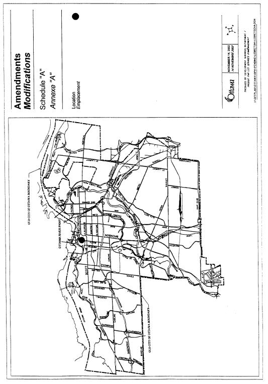
The subject property is located generally to the east of the Canadian National railway tracks, west of Commissioner Street, to the north of Wellington, Slater and Albert Streets and south of the Ottawa River. It is commonly known as LeBreton Flats and forms the western extension of the Central Area (see Document 5).
In 1997, the former City of Ottawa adopted an Official Plan Amendment establishing a development strategy for LeBreton Flats. This Amendment, approved by the Ontario Municipal Board in June of 1999, is included as part of the Central Area Secondary Policy Plan. The LeBreton Flats Secondary Policy Plan recognizes LeBreton Flats as a unique site that should develop with a mix of uses, surrounded by open spaces, pathways and pedestrian friendly streets. The intent of this secondary plan is to create a place where people live, work, socialize and play, with the emphasis on mixed-use development. This intent was also addressed in the former Regional Official Plan, which contains policies to guide in the development of LeBreton Flats to ensure that environmental and heritage issues are addressed.
The National Capital Commission (NCC) now wishes to proceed with the development of the site and is requesting modifications to the former Regional Official Plan as well as the LeBreton Flats Secondary Plan in the former City of Ottawa Official Plan. These requested modifications include changing the boundaries of various Official Plan designations, modifying allowable building heights for certain areas and modifying the text of policies relating to required planning and engineering studies. To implement the requested Official Plan designation changes and building height modifications, the applicant is also requesting amendments to the implementing zoning.
In addition to the applicant’s requests, the Department is also recommending that additional modifications be made to the Secondary Plan to provide specific direction and clarification to ensure that development will be orderly and will address specific matters of interest to the City. The basis for the Department’s recommendation for approval of each of these modifications is presented below.
DISCUSSION
OVERVIEW
The amendments proposed to the former Regional Official plan, to the former City of Ottawa Official Plan and to the former City of Ottawa Zoning By-law 1998, reflect refinements to existing policy and to the current zoning. The proposed amendments maintain the overall spirit and intent of current policies and zoning to have the area develop with a mix of uses so as to extend the urban fabric of the Central Area to include LeBreton Flats, and to ensure that development will occur in a way that responds to and addresses the site’s unique challenges with respect to such matters as site remediation, servicing, and transportation.
The proposed land use changes will not diminish either the mixed use or the residential development potential, but rather are being proposed to provide for flexibility in developing the lands where the land use changes are proposed. Similarly, the proposed expansion of certain areas where higher buildings will be permitted will allow for rationalization of development for the blocks affected.
The text changes proposed, as part of the Official Plan Amendments will provide a more normalized process for development approvals by linking required studies to application types that are specific to development proposals. The overall framework for studies has been established through the master studies that have been completed. These will serve as benchmarks against which development proposals will be evaluated.
AMENDMENT TO FORMER REGIONAL OFFICIAL PLAN
The former Regional Official Plan includes a policy directive pertaining to LeBreton Flats that requires a Phase II Environmental Site Assessment for the entire site prior to the submission of the initial development application. For the site, many of the Phase I and 2 Environmental Site Assessments were completed prior to 1997, when the Region’s Official Plan was adopted. The Regional Official Plan incorporated reference to Ministry of the Environment guidelines released in 1997.
The former City of Ottawa Official Plan includes similar policy directives as set out in the Regional Plan. While these are proposed to be modified to reflect the acceptance by the City and The Ministry of the Environment of the Phase I and II Environmental Site Assessments completed prior to the release of the 1997 guidelines, it is no longer necessary, as a result of amalgamation, to have similar polices included in both Official Plans. For this reason, the Regional Official Plan is proposed to be amended to refer to the similar former City Official Plan policy. This maintains the intent of the Regional Official Plan in requiring that Phase II Environmental Site Assessments be prepared, but defers on the details of this requirement to the former City Official Plan.
AMENDEMENTS TO FORMER CITY OF OTTAWA OFFICIAL PLAN
The amendments proposed to the former Ottawa Official Plan comprise schedule changes to redesignate certain lands, map changes to modify building height limits for certain areas, and text changes to the LeBreton Flats Secondary Policy Plan.
1. Land Use Designation Changes and Building Height Modifications
The Land Use designation changes and building height modifications do not significantly change the overall development framework established for LeBreton Flats. Rather, the changes reflect a redistribution of uses and a rationalization of height limits to increase flexibility for development of the affected lands, which are focused along Booth Street and LeBreton Boulevard. The original development concept established for the blocks affected was directed to achieving mixed-use development and to define strong residential areas. The land use designations and height limits established through the Secondary Plan put in place split designations and split height limits for certain blocks. Through the more detailed work undertaken by the NCC to define the development parcels and to refine the urban design guidelines developed for the site, the split designations and split height limits for the blocks where modifications are being proposed presented artificial constraints to achieving the development called for within these areas.
To confirm that the requested amendments would not undermine the base-planning framework established for the development, the National Capital Commission submitted updated servicing and transportation studies. These have been reviewed and staff concur that the land use designation changes and modifications to building heights will not result in significant additional demands beyond those originally identified and will provide increased flexibility for the development of those blocks where split designations and split height limits were originally established.
There is also a need to ensure that the modifications will not result in development that undermines the objectives of the Secondary Plan, which is to have those areas behind properties along LeBreton Boulevard and Booth Street develop as strong residential neighborhoods with a human scale development. Consequently, additional policies are recommended. Specifically, to ensure that appropriate scale relationships will be provided between development where a 10 storey building height limit is proposed to be established and adjacent areas where a six storey building height limit applies, a policy is proposed that will require higher profile development along those streets where differing building height limits apply, to integrate with lower profile development through various techniques as set out in the Urban Design section of the Official Plan (Central Area Urban Design Policies and General Urban Design Policies).
2. Text Modifications
The modifications requested by the NCC to the text of the LeBreton Flats Secondary Policy Plan to deal with rationalizing the timing for various studies. The Secondary Plan when developed set out a series of requirements for studies to be completed and accepted prior to the submission of the initial application for development. These studies dealt with requirements to have a Master Servicing Plan prepared, to have a Stormwater Management Plan prepared, to have Urban Design Guidelines prepared and to have an Environmental Site Assessment prepared. The plan also set out requirements for studies to be completed prior to development approvals. The development approvals cited include rezonings, subdivisions applications, site plan and consent applications. Those policies where modifications have been requested, presently establish requirements and prerequisites to the submission of a development application. These can be considered onerous as they are outside the normal process followed for any other development initiative in the city. A brief description of the proposed modifications, as requested by the NCC is presented below.
Policy 1.11.4.2a) - SOIL AND GROUND WATER CONTAMMINATION
This policy relates to undertaking an assessment of Soil and Ground Water Contamination. It requires this to be done in accordance with the Ministry of Environment Guidelines from 1997. The Department is recommending amending this policy to allow environmental assessments that were completed before 1997 to be used. These are relevant studies and address pertinent environmental issues.
The new wording will require these studies prior to the approval of relevant subdivision, site plan control and severance applications, as this is when these types of studies are typically required. Currently, they are required prior to the submission of the initial application for development. This new wording will also clear up any conflict between the City and former Regional policies, which requires that Phase II Environmental Site Assessments be completed prior to approval of the initial development application for the Flats.
Policy 1.11.4.2b) - RISK-BASED EXPOSURE ASSESSMENT
This policy requires an assessment of risk for exposure to site contaminants. The Department is recommending that this policy be deleted from the Secondary Plan. It is redundant as the requirements for this type of Assessment already is included in the Ministry of the Environment Guidelines and would be addressed as part of the required Environmental Evaluation of the Site.
Policy 1.11.4.2c) - SITE REMEDIATION PLANS
This policy requires that a Municipal Environmental Evaluation Report (MEER) be submitted to the City, prior to the final approval of a development application. The Department is recommending that the wording be amended to read that the Environmental Evaluation Report be submitted prior to the final approval of a subdivision, severance or site plan application as such reports are appropriate for these types of applications and this is the appropriate timing for their completion.
Policy 1.11.4.3c) - STORMWATER MANAGEMENT
This policy relates to the requirement of a Stormwater Site Management Plan to regulate the amount and flow of stormwater into City sewers. This policy necessitates that these studies be provided with applications for development approval. These types of studies are typically associated with subdivision, site plan and severance applications. Consequently, the Department is recommending revising this policy to require these studies prior to the approval of these applications, where necessary.
Policy 1.11.4.4b) - WIND TESTING
This policy requires wind testing for medium and high profile buildings to determine the effects on the surrounding lands and pedestrian activity. This policy requires that these studies be completed prior to development applications. As these types of studies are associated with the specific building that is being proposed, the Department is recommending that this policy be amended to require such studies for site plan applications.
Policy 1.11.5.1a)iii - DEVELOPMENT PRECONDITIONS
This policy relates to the timing for the provision of a Phase II Environmental Site Assessment of Contamination study. As this already has been addressed in Section 1.11.4.2.a), it is not required and is recommended for deletion.
Policy 1.11.5.1b) - DEVELOPMENT PREREQUISITES
This policy requires that for each development application, a list of studies be prepared prior to the approval of that application. Certain studies are best associated with certain types of development applications, such as a noise study with a subdivision or site plan control application. The Department is recommending revising the policy to require the specific studies for specific development applications, not the entire list for each application.
3. Additional Modifications
In addition to recommending approval of the modifications requested by the NCC, staff is also recommending modifications to existing policies and to add new policies to the Secondary Plan. These establish specific policy direction and clarification with respect to various matters where it is deemed necessary to ensure that development will be orderly and that development will address other City objectives and interests. The following is a brief explanation of these new polices.
Policy 1.11.3.2 h) - MAJOR OPEN SPACE
The existing policy requires that the area designated for a municipal park be developed as a park when the first 500 residential units are provided. The first subdivision phase will allow for approximately 530 units to be developed east of Booth Street. The park block is located away from the initial proposal for residential development as well as any roads. Consequently, construction of a park, as required, would occur away from homes, with no means of access. The Department therefore is recommending an amendment to this policy to require the construction of the park when development occurs on land adjacent to the park area.
Policy 1.11.3.3g) – MIXED USE AREA
This policy will ensure that predominantly residential development will be located within those areas designated Mixed Use that abuts local residential streets.
Policy 1.11.3.4b) - AFFORDABILITY AND ACCESSIBILITY
Presently, there is a requirement under the policies of the Secondary Plan, which makes reference to policies in the Primary Plan, to provide affordable housing, including core need housing. While the Department has no concern with respect to having affordable housing developed, there currently is no clear direction for having core need housing or less affordable housing constructed. Consequently, the Department is recommending modifications to the policy to require that lands be reserved through conditions of subdivision approval for core need housing. Should this housing not be developed within a certain timeframe, the City will have the opportunity to acquire the lands for the purpose of developing core need housing.
Policy 1.11.4.1 r) - PUBLIC TRANSIT
This is a new policy to be introduced into the LeBreton Flats Secondary Plan and establishes a commitment for Council to develop a transit service plan that would place a priority on public transit. This plan would deal with the provision of adequate infrastructure and Transportation Demand Management to meet public transit goals.
Policy 1.11.4.1 s) - ROADWAY CONCEPT PLAN
This is a new policy intended to establish consistent standards for the development of local roads during subdivision approvals.
Policy 1.11.4.4 c) vii) - BUILDING HEIGHTS
This policy will ensure an appropriate scale relationships along streets where there is a height limit of 10 stories on one side of the street and a height limit of six stories along the opposite side of the street, as shown on map 4 in the Official Plan and Document 2 of this report.
Policy Reference Numbers
A policy is being added to the
LeBreton Flats Secondary Plan since policy reference numbers in the plan may
need to be amended as a result of the new policies being added, deleted and
modified. As this is an administrative
matter, City staff will have the ability to make these modifications, without
going back to Council to seek permission to make further reference number
amendments to the Secondary Plan.
AMENDMENTS TO FORMER CITY OF OTTAWA ZONING BY-LAW
With each proposal to change the Official Plan designation and modify building heights of certain properties, there are corresponding recommendations to change the zoning, which will allow conformity with the Official Plan and to achieve planning goals.
1. Changes to Parent CN9 and R6K Zones
The Department is recommending amending Table 321c in the Neighbourhood Commercial (CN9) subzone and Table 280k in the Residential (R6K) subzone. These tables establish a requirement for a 0.5 metre setback for a front yard, or a corner side yard abutting LeBreton Boulevard. As part of the development of LeBreton Flats, LeBreton Boulevard will be realigned further to the north, meaning that certain properties having these zones will no longer abut LeBreton Boulevard, but will be adjacent to a thin strip of land zoned L1G H(21.0) SCH 225, 226 or L2B SCH 225, 226. Tables 280k and 321c require a zero metre setback be provided where lands abut these open space zones. To maintain the original intent to have a 0.5 metre setback along LeBreton Boulevard, the Department is recommending that these tables be amended to include lands not only abutting LeBreton Boulevard, but the respective L1G and the L2B zones as well. It is recognized that amending the R6K zone as proposed will result in a 0.5 metre setback for properties abutting the L2B zone adjacent to Area 6 shown on Document 5. The Department does not believe there will be any negative planning aspects from having this setback.
2. Changes to the CN9 (746)H(40.0) SCH225,
226 Zone
The current CN9(746)H(40.0) SCH. 225, 226 zone is proposed to be amended by adding new text to the exception. This exception will deem Booth Street as the front yard for those lots with a lot line along Booth Street. This provision will ensure that lots along Booth Street will be developed to provide a consistent setback for buildings, so as to establish a vibrant, pedestrian friendly character along this street.
3. Residential to
Mixed Use
The lands in LeBreton Flats which are proposed to be redesignated from Residential to Mixed Use, are proposed to be rezoned from their current residential zoning to a CN9H(40.0) SCH. 225, 226 exception zone. This is a similar zoning to that which applies to adjacent lands designated Mixed Use and will allow the subject lands to become part of that larger block of land with this designation.
The difference between this zone and the adjacent CN9 Zone is that the provision to have Booth Street, as the front lot line does not apply, as it is not needed and that Section 295(2) of the Zoning By-law not apply. These lands to be rezoned are located along Lloyd and Sherwood Streets. Section 295(2) of the Zoning By-law requires that certain permitted uses, such as residential and office type uses, be located above the ground floor. The intent of this provision is to have the ground floor of development in the CN zone accommodate commercial uses that will contribute to a vibrant, animated commercial street to support pedestrian activity.
The Department is recommending that Section 295(2) not apply to these lands as they abut streets, which also share a residential zoning and therefore are to be developed with residential uses at ground level. Not having this section apply to the subject CN9 zoned lands will allow complementary residential uses and some commercial uses to exist on the ground floor. The commercial uses, which will be permitted, will not result in a high level of pedestrian traffic and are considered appropriate for this location. To this end, the Department is also recommending allowing only those commercial uses in Section 294 which are believed to serve the local residential uses and do not have a high probability of resulting in a large volume of pedestrian and vehicular traffic from outside the neighbourhood.
4. Cultural/Office
to Residential
This block is shown as Area 6 on Document 5 and is proposed to be rezoned from its current cultural CP2H(24.5)SCH225 226 zone to a high rise apartment R6K(745)H(40.0)SCH 225, 226 zone. This is the current zoning of the adjacent Block, which is proposed to be zoned CN, as described above. This zoning is recommended for approval to allow conformity with the proposed Official Plan Amendment. As well, while this block of land is smaller than the adjacent block, which is being rezoned from R6K(745)H(40.0)SCH 225, 226 to a CN zone, it will allow a residential development compatible with that which would have been permitted on the adjacent block. Rezoning this land to residential will help fulfill the overall residential goal of development on LeBreton Flats.
5. Height Increase
The lands zoned as R7D(743)H(20.5) and shown on Document 5 are proposed to have an increased height limit from 20.5 to 40.5 metres. The adjacent lands to the east already have the identical zoning with the 40.5 metre height limit. Rezoning the lands with the 20.5 metre height limit to allow a building height of 40.5 metres will provide for increased flexibility to construct a development of higher density next to Booth Street, subject to meeting the Urban Design Policies of the Official Plan.
6. Rezoning the
Leisure Zone to Allow a Right-of-Way
The applicant is proposing to rezone lands shown on Document 5 from Leisure L2B to a new L2B exception zone. The lands to be rezoned are small on their own and represent a segregated portion of the greater L2B zone. Rezoning this “finger” of land to allow a right of way will not diminish the meaning of the L2B zoning for the area and will allow access to the subject lands from the property to the north.
CONSULTATION
Notification was carried out in accordance with the City Public Notification and Consultation Policy by the posting of on-site signs and a circulation to Concerned Community Groups. No responses were received as a result of the public notification.
Councillor
Arnold provided the following comments on the Official Plan Amendment and
rezoning applications that also address certain issues related to the
subdivision application being processed by the Department.
“Transportation Issues
Four lane roads are the maximum that will lead to a livable environment in the new community on LeBreton Flats. We must insist on design solutions that do not require freeways through this site, that will only result in bottlenecks at the access points to the site, which are all 4 lanes. This will include exploring the options of:
1. Accepting congestion and traffic displacement
2. Grade separation
3. Reduced commercial density on the site
4. Shared auto-transit right of way on Booth (which might require a slightly wider right of way)
5. Any other creative solutions
Lane Use Issues
I am told that the City will be opposing any requests to increase commercial density on the site, and ensuring that residential units are required in mixed-use zones, rather than permitted. I fully support this position.
Affordable Housing
I continue to be concerned that there is no requirement for a portion (25%) of the housing to be “ affordable”. I have been meeting with some housing activists in the City who share this concern, and they are going to be approaching the NCC to see how this can be incorporated. I encourage you to pursue this as well, and keep me informed of any progress you make in this regard.”
The Councillor
has also attached an appendix to this submission that includes additional
comments from the Councillor and the public, received after the completion of
this document.
FINANCIAL IMPLICATIONS
N/A
APPLICATION PROCESS TIMELINE
STATUS
These applications were not processed within the timeframe established for the processing of Official Plan and Zoning Amendment applications as a result of a need to address complicated land use planning issues.
ATTACHMENTS
Document 1 – Proposed Amendment to the former Region Official Plan
Document 2 – Proposed Amendment to former City of Ottawa Official Plan
Document 3 – Explanatory Note
Document 4 – Details of Recommended Zoning
Document 5 – Location Plan
Document 6 – Consultation Details
DISPOSITION
Corporate Services Department, Secretariat Services to notify the owner The National Capital Commission (202-40 Elgin Street, Ottawa, Ontario K1P 1C7 Attention Robert Walters) of Council’s Decision.
Corporate Services Department, Legal Services to forward to City
Council the by-laws to adopt the amendment to the former Regional Official
Plan, to adopt the amendment to the former City of Ottawa Official Plan and to
implement the zoning changes.
Development Services Department
i) To write and circulate the implementing Zoning By-law.
ii) To prepare and circulate the notices of adoption of the amendments to the former Regional Official Plan and former City of Ottawa Official
Document 1
|
|

Official Plan Amendment 28 /Modifications du Plan
directeur
To the Official Plan of the former Region of
Ottawa-Carleton, now forming part of the City of Ottawa Official Plan
Land use
Utilisation du sol
_______________________________________________________________________
INDEX
________________________________________________________________________
The Statement of Components
PART A - THE PREAMBLE
Purpose
Location
Basis
PART B- THE AMENDMENT
Introductory Statement
Details of the Amendment
Implementation and Interpretation
PART C - APPENDIX
Appendices
THE STATEMENT OF COMPONENTS
PART A - THE PREAMBLE, introduces the actual Amendment but does not constitute part of Amendment No. 28 to the former Regional Official Plan of Ottawa-Carleton, 1997.
PART B - THE AMENDMENT, consisting of text constitutes the actual Amendment
No. 28 to the former Regional Official Plan of Ottawa-Carleton, 1997.
PART C - THE APPENDIX, does not form part of the Amendment but is provided to clarify the intent and to supply background information related to the Amendment.
PART
A - THE PREAMBLE
Purpose
The purpose of Amendment No. 28 is to amend the wording of Policy 11.4.6 to correspond with the wording and the intent of similar policy in the former City of Ottawa Official Plan set out in the LeBreton Flats Secondary Policy Plan, related to soil contamination and remediation.
Location
This policy amendment affects the lands known as LeBreton Flats, generally located south of the Ottawa River, north of Wellington, Albert and Slater Streets, east of the Canadian National Railway and west of Commissioner Street.
Basis
Policy 11.4.6 in the former Regional Official Plan applies specifically to LeBreton Flats and requires a Phase II Environmental Site Assessment in accordance with Ministry of the Environment Guidelines for Use at Contaminated Sites in Ontario; which were brought in to effect by the Provincial Government in 1996/1997. It also requires that this study be completed for the entire site (except under road beds that are not accessible), prior to the approval of the first development application for LeBreton Flats.
The National Capital Commission is requesting an amendment to Policy 11.4.6 of the former Regional Official Plan to reflect the fact that many of the Phase I and II environmental assessments were completed prior to the release of the Ministry’s 1996/1997 guidelines. The City has agreed that pre 1996/1997 Phase II environmental studies are appropriate and will address relevant environmental concerns. As such, the former Regional Official Plan is being amended to have Policy 11.4.6 refer to a similar policy in the former City of Ottawa Official Plan. These two similar policies have existed since the inception of the former Regional Official Plan in 1997 and with amalgamation, it is appropriate to have one policy refer to another, instead of having two independent, yet similar policies.
In referring to the similar policy in the former City of Ottawa Official Plan, the salient point of this Regional policy will continue to be addressed, namely, that the Phase II Environmental Site Assessment be completed for the entire site, save and except under road beds and that reference be made to other applicable former Regional Official Plan policies.
PART B - THE AMENDMENT
THE INTRODUCTARY STATEMENT
All of this part of the document entitled Part B - The Amendment, consisting of the following text constitutes Amendment No. 28 to the Regional Official Plan of Ottawa-Carleton, 1997
DETAILS OF AMENDMENT
The Regional Official Plan of Ottawa-Carleton is amended as follows:
1. Section 11.4.6 – Contaminated Sites – LeBreton Flats – is hereby be amended by replacing the present policy with the following:
“In order to implement Policy 3 above with respect to LeBreton Flats, Policy 1.11.4.2a of the former City of Ottawa’s Central Area (LeBreton Flats) Secondary Plan shall apply”.
IMPLEMENTATION AND INTERPRETATION
Implementation and Interpretation of this Amendment shall be made having
regard to applicable policies of this Plan.
PART C- THE APPENDIX
The following is revised condition 1.11.4.2a), contained in the former
City of Ottawa Official Plan:
“City Council shall require environmental site assessment and restoration within the spirit of the Ministry of the Environment Guidelines for Use of Contaminated Sites in Ontario 1996 (revised February 1997), or other federal, provincial, or municipal regulations, as applicable, in effect at the time of development. In this regard, a Phase II Environmental Site Assessment shall be completed within the spirit of the Guidelines, prior to the final approval of a subdivision, severance or site plan control application for the area of such application. It is acknowledged that both City Council and the Ministry of the Environment have accepted certain Phase I and Phase II Environmental Site Assessments completed prior to the release of this guideline, towards fulfilling the spirit of the Guideline”.
|
|

Document 2
Official Plan
Amendments 57/Modifications du Plan directeur 57
To the Official Plan of the former
City of Ottawa, now forming part of the City of Ottawa Official Plan
Land use
Utilisation
du sol
________________________________________________________________________
INDEX
________________________________________________________________________
The Statement of Components
PART A - THE PREAMBLE
Purpose
Location
Basis
PART B- THE AMENDMENT
Introductory Statement
Details of the Amendment
PART C - APPENDIX
Appendices
THE STATEMENT OF COMPONENTS
PART A - THE PREAMBLE, introduces the actual Amendment but does not constitute part of Amendment No. 57 to the former City of Ottawa Official Plan.
PART B - THE AMENDMENT, consisting of the following text and maps constitutes the actual Amendment No. 57 to the former City of Ottawa Official Plan.
PART C - THE APPENDIX, does not form part of the Amendment but is provided to clarify the intent and to supply background information related to the Amendment.
PART A - THE PREAMBLE
1.0 Purpose
The purpose of Amendment No. 57 is to change the land use designation and modify allowable building heights for certain lands within LeBreton Flats and to amend existing policies set out in the LeBreton Flats Secondary Plan included in the Central Area Chapter of Volume II of the former City of Ottawa Official Plan. The polices to be amended modify the timing for various studies as part of the development approvals processes and provide specific policy direction and clarification with respect to various matters to ensure orderly development and to address specific City interests.
2.0 Location
The lands affected by the amendment are known as LeBreton Flats and are generally located south of the Ottawa River, north of Wellington, Albert and Slater Streets, east of the Canadian National Railway and west of Commissioner Street.
3.0 Basis
3.1
Background
In 1997, the City Council of the former City of Ottawa passed an Official Plan Amendment establishing a development strategy for LeBreton Flats. This Official Plan Amendment, approved by the Ontario Municipal Board in June of 1999, was incorporated as part of the Central Area Secondary Policy Plan included in the City of Ottawa Official Plan. The LeBreton Flats Secondary Plan recognizes LeBreton Flats as a unique site that should develop with a mix of uses, surrounded by open spaces, pathways and pedestrian friendly streets, to create a place where people live, work, socialize and play. With the emphasis on mixed-use development as a priority, to create a balance of jobs, housing and a more efficient use of valuable urban land and infrastructure, LeBreton Flats would help define the role of Ottawa as the National Capital. The Land Use designations set out in the LeBreton Flats Secondary Plan and corresponding zoning established for the entire site, are to accommodate this development goal.
In addition to designating the land within LeBreton Flats, the Secondary Plan also contains polices to guide development, relating to such issues as environmental concerns, affordable housing, stormwater design, wind testing, noise studies, public transit, roadway design, building height and park land. Policies such as these are intended to ensure that the development proposed is compatible with other development in the Flats and safe for the people who will work, live and play there. Changes to the existing text of the Secondary Plan are proposed to clarify existing policies, to ensure that specific goals are achieved and to reflect current situations. The basis for the Land Use Designation changes, building height modifications and policy modifications is presented below.
3.2 Context
of Amendment
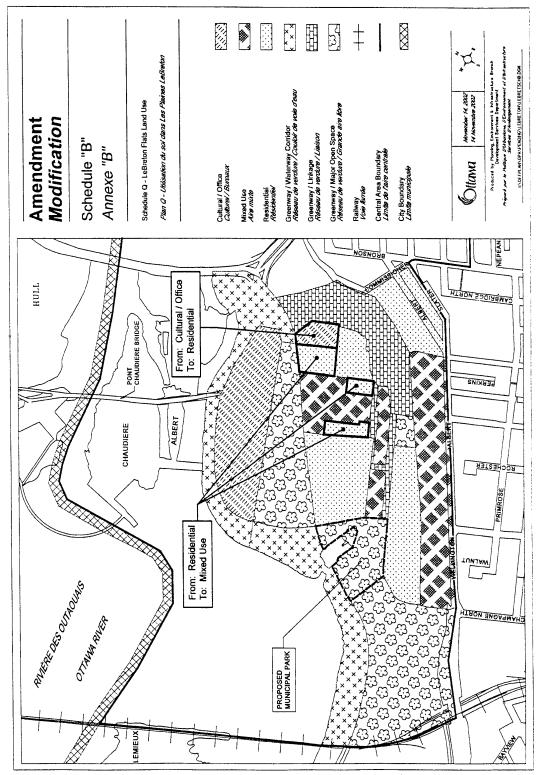
The applicant is requesting modifications to change the boundaries of land use designations located on Schedule Q of the LeBreton Flats Land Uses and Map 4, Maximum Building Profile and Conceptual Road Pattern, of the former City of Ottawa Official Plan. The changes can be seen on Schedule “B” and “C” of this Amendment and include redesignating certain Residential Areas to Mixed Use, redesignating a Cultural/Office Area to Residential, and increasing allowable building height.
Residential to Mixed Use
An important component of development within LeBreton Flats, as established by the Secondary Policy Plan, is the Residential component. The policies of the Plan provide that a range of housing forms at medium to high densities, appropriate to the downtown area be accommodated to make effective and efficient use of infrastructure and services. Of these homes, 25% are to be affordable housing, with 10% of units being core need housing.
The Mixed Use designation permits a broad range of uses including residential, retail, office, entertainment, cultural and recreational, to serve the needs of the community. Consequently, amending the designation of certain lands as proposed does not preclude the possibility of residential dwellings from occurring on those lands, which will help to meet the intent of the Secondary Plan for LeBreton Flats respecting housing. Rather, the Land Use designation changes to expand certain mixed-use areas will increase flexibility in developing those areas, which currently carry split designations.
The lands to be redesignated to Mixed Use only represent a small amount of area that is presently designated Residential. Within the development, there are four separate areas designated as mixed use. These are all focused around the southern portion of LeBreton Flats and around Booth Street, which is the central spine for the site. The lands to be included in the mixed-use designation will normalize a single designation for blocks along Booth Street to better facilitate development. The residential component of the mixed-use development of these lands would be oriented to the residential streets to contribute to the creation of the residential community.
Cultural/Office to Residential
The Cultural/Office designated lands within LeBreton Flats are located on the northern portion of the site to form a Western anchor for Confederation Boulevard and the Parliamentary Precinct. The uses intended for lands with this designation include museums, art galleries and offices. Supporting uses, which create lively people places, such as retail and restaurants, are also permitted. There are two areas having this designation in the LeBreton Flats Secondary Plan. One large area north of LeBreton Flats, where the new Canadian War Museum is to be located and a second smaller area near the eastern boundary adjacent to the tailrace for the aqueduct This smaller area is being redesignated to residential.
The Cultural/Office designation of this parcel was put in place to accommodate an aquarium, which is no longer planned for this site. The redesignation of these lands to residential will consolidate the residential lands between the Greenway Lands to the east and the mixed use lands to the west as well as support the significant residential component that is LeBreton Flats. Redesignation of this land will not depart from the concept for LeBreton Flats to have more institutional uses to serve as a west anchor for Confederation Boulevard.
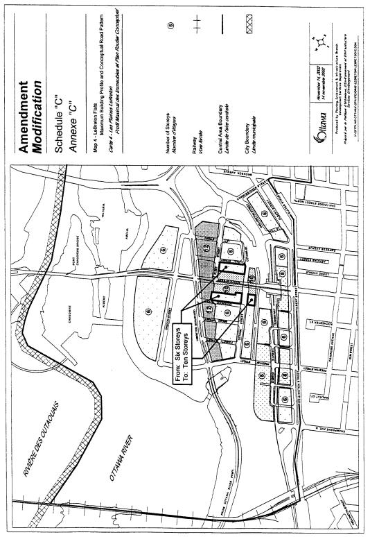
Increased Maximum Height
In addition to consolidating and rationalizing the Land Use designation for certain blocks, to allow increased flexibility in developing these lands, the National Capital Commission is also requesting that the allowable height limits, as established in the LeBreton Flats Secondary Plan on Map 4, be amended. This is shown in Schedule “C” of this document and will allow an increase from six to ten storeys.
Height limits within LeBreton Flats range from six to 12 storeys. These heights were established to ensure compatibility with the existing residential community to the south, while providing an opportunity for higher buildings along the entrances to LeBreton Flats, as well as close to the transitway station and along arterial roadways. It is also intended to avoid a continuous high-profile wall of buildings while also protecting views to the Parliament Buildings and other National Symbols.
The lands where building height limits are being modified are the same lands that are being redesignated from residential to mixed use and do not interfere with any of the protective views to the Parliament Buildings and National Symbols. This will provide a consolidation of the majority of the lands designated Mixed Use, which already have a ten storey height limit to establish a single maximum height limit for lands with the mixed use designation. This will allow for flexibility in designing development. To ensure that the increase in allowable height will not adversely overshadow or impact adjacent areas where a six-storey height applies, a text change is being made to require that the scale of developments relate harmoniously with development of adjacent residentially designated lands through the use of various design requirements as set out by the Urban Design Policies of the Official Plan.
Text Modifications
In addition to the amendment of land designation boundaries, the Department is also recommending amendments to policies contained within the Secondary Plan. The rationale for these changes is presented below.
Policy 1.11.3.2 h) – MAJOR OPEN SPACE
A City park is required for LeBreton Flats after the construction of the first 500 residential units. The land set aside for this park is located south of the inlet to the aqueduct on the western portion of the site. The Phase I subdivision submitted by the National Capital Commission will allow for the development of approximately 530 units for the eastern portion of the development, east of Booth Street. The Park Block is removed from the first phase of development and will not be accessible. Consequently, the construction of a park as required, would occur away from homes, with no means of access. To reflect this reality, the Department is recommending amending policy 1.11.3.2h) to require the construction of the park when a subdivision is registered or a Site Plan Control Application is approved for lands adjacent to the park area.
Policy 1.11.3.3g) – MIXED USE AREA
To ensure that the development of lands in the Mixed Use Area, that abut or front onto local residential streets will be developed with residential uses, a new policy is being added to the Secondary Plan.
Policy 1.11.3.4.b) – AFFORDABILITY AND ACCESSIBILITY
While residential development is a major component of the plan for LeBreton Flats, there are policies in the former City of Ottawa Official Plan, Policy 3.2.2.a)i, which require that a minimum amount of housing in major development projects be affordable housing and that a percent of the affordable housing be constructed as core need housing. This policy is reflected in the LeBreton Flats Secondary Plan, in Policy 1.11.3b). While the Department has no concern with respect to having affordable housing developed, there currently is no clear direction provided to ensure that core need housing targets will be met. Consequently, the Department is recommending modifications to add to the existing policy to require that lands be reserved for development of core need housing as part of the subdivision approval process. Should the reserved land not be developed for core need housing within five years of subdivision registration, the City will have the first opportunity to develop the lands for this housing.
Policy 1.11.4.1 r) – TRANSIT SERVICE PLAN
Through the review of the applications submitted by the NCC for modifications to the policies of the LeBreton Flats Secondary Plan, it was determined that a need existed to establish a clearer policy statement that would support having the area develop with a strong orientation to public transit. In this regard, while the current secondary plan establishes policies related to the Transitway, there is no policy directive related to general transit service and how this would integrate with the city’s overall transit system. A new policy is therefore being included that establishes a priority for City Council to develop a transit-servicing plan for LeBreton Flats. This plan would address matters related to the provision of infrastructure and facilities, including pathway connections, possible establishment of transit priority lanes, and the development of Transportation Demand Management plans through development approval processes.
Policy 1.11.4.1 s) – ROADWAY CONCEPT PLAN
Policies exist in the LeBreton Flats Secondary Plan that provide direction for having roads within LeBreton Flats developed to incorporate alternative standards and traffic calming features. In response to these directives, work has been ongoing to develop a comprehensive roadway concept plan that identifies road cross sections for the various streets to be developed and/or improved and identifies how services would be accommodated to meet the needs of the various utilities. Implementation of the concept plan will occur through subdivision approvals and/or through road openings. To ensure that roads will be developed to implement the roadway concept plan, a new policy is proposed requiring that the roadway concept plan be approved and that once approved, that it serve as the basis for defining/detailing conditions related to the construction of roads through future development approvals.
Policy 1.11.4.2 a) – SOIL AND GROUND WATER CONTAMINATION
This policy in the Secondary Plan relates to undertaking an assessment of Soil and Ground Water Contamination. Part of this policy provides that an environmental site assessment and any required restoration, be done in accordance with the Ministry of Environment “Guidelines for Use of Contaminated Sites in Ontario 1996 (revised February 1997), or other federal or provincial regulations in effect at the time of development and that a Phase II Environmental Site Assessment as described in the 1996 Ministry of the Environment Guidelines be completed prior to the submission of the initial development application. The intent of this policy is to ensure that environmental studies relating to these issues are undertaken to a certain standard and that any issues which may arise are identified and addressed.
To reflect the changes introduced by the Ministry of the Environment, the Department is recommending amending the wording of this policy to allow environmental assessments that were completed before 1996 to be used. This reflects the agreement by the City and the Ministry of the Environment that the Phase I and II Environmental Site Assessments completed before the 1996 Guidelines are in the spirit of the Guidelines and are considered acceptable. Towards this end, the policy is being modified to require environmental assessments to be conducted in “the spirit” of the Ministry’s Guidelines, rather than according to the principles of the Guidelines. Regulations of other levels of government will also apply, where applicable.
The new wording will also require the submission and acceptance of Phase II Environmental Site Assessments prior to the final approval of a subdivision, severance, or site plan control application for the area of such application (save for lands under existing road beds which can not be tested), rather than prior to submission of the initial application for development. This will normalize when such studies typically are required during the development approval process and will clarify a conflict between this plan and the former Regional Plan, which required these studies prior to the approval of the initial application.
Policy 1.11.4.2b) – RISK-BASED EXPOSURE ASSESSMENT
This policy requires an assessment of risk for exposure to site contaminants. It was introduced in the Secondary Plan to provide the opportunity for the applicant to keep contaminated soil on property that would be sold to the public, if the risks could be managed and was written prior to the Ministry of the Environment Guidelines of 1996/1997. The Department is recommending that this policy be deleted from the Secondary Plan for two reasons:
1. The requirements for this type of Assessment are already included in the Ministry of the Environment Guidelines and would be addressed as part of the required Environmental Evaluation of the Site.
2. The National Capital Commission has indicated that it is not proposing to remediate any of the private sector lands by way of a Risk Based Exposure Assessment. Instead, it will be employing generic remediation, which involves the removal of contaminated soil and replacement with clean fill.
Policy 1.11.4.2c) – SITE REMEDIATION PLANS
This policy requires that a Municipal Environmental Evaluation Report be submitted to the City, prior to the final approval of a development application and is intended to ensure that municipal environmental concerns are addressed as part of a development.
This policy presently requires a Municipal Environmental Evaluation Report (MEER) prior to any development applications. As they are more appropriately associated with a subdivision, site plan control and severance application and often form a condition of approval of these types of applications, the Department is recommending that the wording be amended to reflect this reality.
Policy 1.11.4.3c) – STORMWATER MANAGEMENT
This policy relates to the requirement of a Stormwater Site Management Plan, to regulate the amount and flow of stormwater into the City sewers. This policy necessitates that these studies be provided with applications for development approval, including zoning applications. These types of studies are typically associated with subdivision, site plan and severance applications and as with a MEER, often form part of the conditions for approval. The new policy reflects that they be provided prior to the approval of these applications, where it is necessary, to be consistent with development approval requirements applied throughout the city.
Policy 1.11.4.4b) – WIND TESTING
This policy requires wind testing for medium and high profile buildings to determine if the characteristics of a proposed building will cause adverse wind conditions for surrounding lands and pedestrian activity. At present, this policy requires such tests prior to approval of applications for development. Studies of this nature are most appropriate prior to site plan when the proposed built form of the development is known. This policy therefore is being amended to require such studies for site plan applications, to better clarify intent reflecting normal practice.
Policy 1.11.4.4 c) vii) – BUILDING HEIGHTS
To ensure that an appropriate scale of relationship will be provided by development along streets where there is a height limit of 10 stories on one side of the street and a height limit of six stories along the opposite side of the street, as shown Schedule “C” of this document, a new policy is being added to the Secondary Plan. This policy will require that higher profile development integrate with lower profile development through various techniques as set out by the Urban Design Policies of the Official Plan contained in the Central Area Section (Chapter 5) and the general Urban Design Policies set out in Chapter 12.0.
Policy 1.11.5.1a iii) – DEVELOPMENT PREREQUISITES
This policy relates to the timing for the provision of a Phase II Environmental Site Assessment of Contamination study. As this has already been addressed in Section 1.11.4.2a), it is not required and is being deleted as part of the Amendment.
Policy 1.11.5.1b) – DEVELOPMENT PREREQUISITES
This policy provides for City Council being assured that required studies have been completed prior to specific development applications to determine the effects of that development on the surrounding land and is included in the Secondary Plan for that very reason. Certain studies are best associated with certain types of development applications, such as a noise study with a subdivision or site plan application. This policy, as currently worded, would require such a study as part of a rezoning application.
The policy is being modified to require specific studies for specific development applications, to be consistent with development approval requirements for different application types.
Policy
Reference Numbers
A policy is being added to the LeBreton Flats Secondary Plan as the policy reference numbers in the plan may need to be amended as a result of the new policies being added, deleted and modified. As this is an administrative matter, City staff will have the ability to make these modifications, without going back to Council to seek permission to make further amendments to the Secondary Plan.
PART B - THE AMENDMENT
1.0 The Introductory Statement
All of this part of the document entitled Part B - The Amendment, consisting of the following text constitutes Amendment No. 57 to the former City of Ottawa Official Plan.
2.0 Details of Amendment
The City of Ottawa Official Plan is hereby amended as follows:
2.1 Schedule Q – Plan Q – LeBreton Flats Land Use is amended to include the following changes shown on Schedule “B” attached hereto:
i) Redesignate the lands generally located south of LeBreton Boulevard, north of Fleet Street, west of the lands presently designated Cultural Office, and east of lands presently designated Mixed Use, from Residential to Mixed Use.
ii) Redesignate the lands generally west of Lloyd Street, bounded on the north and west sides by the lands designated Mixed Use and north of lands designated Greenway, Waterway Corridor, from Residential to Mixed Use.
iii) Redesignate the lands generally west and south of lands designated Mixed Use, on the west side of Booth Street, east of Sherwood Avenue north of lands designated Greenway/ Waterway Corridor, from Residential to Mixed Use.
iv) Redesignate the lands generally located south of LeBreton Boulevard, to the west of lands Designated Greenway/Waterway Corridor, and north and east of lands presently designated Residential Area, from Cultural Office to Residential.
2.2 Map 4- LeBreton Flats Maximum Building Profile and Conceptual Road Pattern is amended to include the following changes shown on Schedule “C” attached hereto:
i) Redesignate the lands shown on Map 4, generally bounded by Sherwood Street to the west, Ottawa Street to the south, the lands having a 12-storey height limit to the north and a 10-storey height limit to the east, from a maximum of six-storeys, to a maximum of 10 storeys.
ii) Redesignate the lands shown on Map 4, generally located west of Lloyd Street, north of Ottawa Street, south of Fleet Street and east of the lands having a maximum height limit of 10 Storeys, on the east Side of Booth Street, from a maximum height limit of six-storeys to a maximum height limit of 10 storeys.
iii) Redesignate the lands generally located south of Ottawa Street, north of the open aqueduct, from the lands having a maximum height limit of 10 storeys, west to Sherwood Street, from a maximum of six storeys to a maximum of 10 storeys.
2.3 City Council shall delegate to staff, the ability to amend the policy numbering system, for policies contained with in the LeBreton Flats Secondary Plan, without the requirement to seek further approval from City Council.
2.4 Volume 2, Chapter 1.0, Central Area, Character Area 1.11 LeBreton Flats is amended by modifying the existing text with the following:
Policy 1.11.3.2 h) is replaced with the following text:
City Council shall require that the municipal park be dedicated and developed within one year of the registration of a plan of subdivision, or the approval of a site plan control application for any lands adjacent to the park.
Add the following to Policy 1.11.3.3g):
City Council shall require that predominately residential development be provided along local residential streets with commercial development focused along Booth Street.
Add the following to Policy 1.11.3.4 b):
In support of the City Council’s commitment to achieve affordable housing including housing for lower income groups within the Central Area, City Council shall require that lands be set aside through the subdivision approval process for development by housing providers (which can include but is not limited to non-profit housing providers including City Living) of housing geared to lower income groups. The amount of land to be set aside shall be sufficient to allow 10% of the total housing stock within LeBreton Flats to be developed for low income housing The subdivision agreements will provide for the holding of these lands for this purpose for a period of five years from the date of the execution of the agreement during which time, the National Capital Commission as land owner will make available the land only to housing providers committed to developing the site for housing for low income groups. Should the lands not be acquired for low income housing within the five year period, City Council will require that the subdivision agreement provide for the City to be given by the National Capital Commission (NCC) the first right to acquire the lands, failing which the lands may be disposed of by the NCC and/or developed in accordance with the zoning and the policies of the Official Plan.
Add a new policy under 1.11.4.1 Transportation policies, to be know as Transit Servicing Plan:
Policy 1.11.4.1 r) – TRANSIT SERVICING PLAN
City Council shall, as a priority, develop in consultation with the National Capital Commission, a transit servicing plan for LeBreton Flats that will be integrated with the City’s transit system and shall require the provision of infrastructure and facilities such as but not limited to pedestrian paths and connections, transit stops, transit priority lanes along new roads, and Transportation Demand Management plans, to support the transit service plan through the development approval process.
Add a new policy under 1.11.4.1 Transportation policies, to be know as Roadway Concept Plan
Policy 1.11.4.1 s) – ROADWAY CONCEPT PLAN
City Council shall require that the National Capital Commission develop a comprehensive roadway concept plan for all the roads to be developed and/or improved within LeBreton Flats. This concept plan will identify roadway cross sections that respond to policies in the Secondary Plan, the location of below and above grade services and will be subject to acceptance by the City and Utility Agencies. City Council will require that the accepted concept plan be used to define/detail conditions related to the construction of roads through subdivision and road opening approvals.
Policy 1.11.4.2 a) is replaced with the following text:
City Council shall require environmental site assessment and restoration within the spirit of the Ministry of the Environment Guidelines for Use of Contaminated Sites in Ontario 1996 (revised February 1997), or other federal, provincial, or municipal regulations, as applicable, in effect at the time of development. In this regard, a Phase II Environmental Site Assessment shall be completed within the spirit of the Guidelines, prior to the final approval of a subdivision, severance or site plan control application for the area of such application. It is acknowledged that both City Council and the Ministry of the Environment have accepted certain Phase I and Phase II Environmental Site Assessments completed prior to the release of this guideline, towards fulfilling the spirit of the Guideline.
Policy 1.11.4.2b) is deleted in its entirety.
Policy 1.11.4.2c) is replaced with the following text:
City Council shall require that site-specific remediation plans and commitments to site restoration be undertaken prior to the final approval of a subdivision, severance or site plan application for the area of such application within LeBreton Flats; in this regard a Municipal Environmental Evaluation Report (MEER) will be required prior to the final approval of such applications.
Policy 1.11.4.3c) is replaced with the following text:
City Council shall require that Stormwater Site Management Plans be submitted prior to the final approval of a subdivision, severance or site plan application, to the satisfaction of the City of Ottawa. These plans shall be consistent with the overall Stormwater Management Feasibility Plan and, where phased development is proposed, will identify any phasing for the implementation of the stormwater site management plan and any necessary interim stormwater management measures.
Policy 1.11.4.4b) is replaced with the following text:
City Council shall require wind testing of medium and high profile development proposals to evaluate the impact on streets, open spaces and other pedestrian activity areas and determine mitigation measures, prior to the approval of applications for Site Plan Control Approval, consistent with policy 5.6.2m) of Volume I of the former City of Ottawa Official Plan.
Add a new policy under 1.11.4.4 c) Urban Design Building Height policies
Policy 1.11.4.4 c) vii)
To ensure that appropriate scale relationships will be provided along streets where development with a height of 10 stories is permitted on one side of the street and a building height limit of six stories is established along the opposite side of the street as shown on Map 4, City Council shall require that the higher profile development integrate with lower profile development through various techniques as set out in the Urban Design Policies of the Official Plan (Central Area Urban Design Policies set out in Chapter 5.0 and the General Urban Design Policies set out in chapter 12.0) to provide for achieving harmonious street environments consistent with the principals set out in the urban design guidelines developed as required by policy 1.11.4.4.
Policy 1.11.5.1a iii) is deleted in its entirety.
Policy 1.11.5.1b) is replaced with the following text:
“City Council shall ensure that the following have been prepared to the satisfaction of the City of Ottawa and the National Capital Commission and other pertinent agencies as appropriate:
i) Traffic Impact Studies as set out in Policy 1.11.4.1c), prior to the final approval of site specific applications for rezoning, subdivision, site plan control or severance;
ii) Phase II Environmental Site Assessment and Contamination studies, as set out in Policy 1.11.4.2a), prior to the final approval of site specific applications for subdivision, severance or site plan control;
iii) Site Specific Remediation Plans as set out in Policy 1.11.4.2c), prior to the final approval of site specific applications for subdivision, site plan control approval or severance;
iv) Noise Studies, as set out in Policy 1.11.4.1d), prior to the Final Approval of applications for subdivision, severance or site plan control; and
v) Stormwater Site Management Plan, as set out in Policy 1.11.4.3c), prior to final approval of applications for subdivision, severance or site plan control”.
PART C - THE APPENDIX
N/A
Explanatory Note Document 3
THE FOLLOWING IS AN EXPLANATORY NOTE TO BY-LAW NUMBER
By-law Number ……………… amends By-law Number, 1998, the former City of Ottawa’s Comprehensive Zoning By-law. This amendment affects those lands known municipally as 555 Ottawa River Parkway (LeBreton Flats). The applicant is requesting amendments to both the former Regional Official Plan and City of Ottawa Official Plan – Secondary Plan for LeBreton Flats. The proposed zoning amendments are intended to implement the requested modifications to the Official Plan as well as allow for modifications to performance standards.
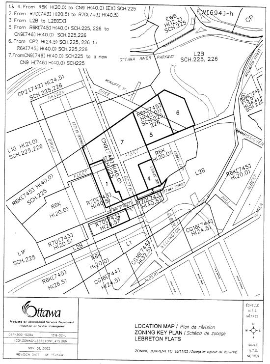
Current Zoning
The current zoning of the lands subject to the rezoning application are R6 K(745)H(40.0), R6KH(20.0), R7(743)H(20.5), CP2H(24.5) SCH225, 226 and L2B. A description of each is presented below.
The R6K zones are high-rise Apartment Zones that allow a wide range of residential uses. The only non-residential uses permitted are a convenience store, a community health and social service centre and a utility installation, subject to specific provisions. The “K” represents a subzone, which in this instance prohibits low-density housing, (e.g. detached dwelling, semi-detached dwelling). The (743) and (745) represent exceptions to the zoning. The [743] exception indicates that an outdoor patio is permitted, subject to special provisions and the [745] exception relates to the location of a passenger loading space. The H(20.0) and H(40.0) represent maximum height of buildings, in metres. The Sch. 225 and Sch. 226 refer to schedules in the Zoning By-law. Sch 225 relates to allowable heights Above Sea Level while Sch. 226 shows where no buildings or structures are permitted.
The R7D(743)H(20.5) zone is a Residential/Service Commercial Zone. This zone permits a wide range of residential uses as well as a wide range of commercial uses. There are restrictions to some of the commercial uses (e.g. restaurants), which require that they not be located above the ground floor and that they be in a residential building. The “D” represents a subzone to the parent R7 zoning. It prohibits certain commercial and residential uses, as well as permits others. It also regulates the location of specific uses, prohibits a drive through and establishes performance standards for development. As with the R6 zone, the (743) is an exception pertaining to this zone which indicates that an outdoor patio is permitted, subject to certain regulations. The maximum height limit for buildings in this zone is 20.5 metres.
The L2B is a Leisure Linkage Zone. The uses in this zone are limited to a botanical garden, a park and a recreational and athletic facility. The number “2” represents a subzone which in this instance, adds a utility installation as a permitted use.
The CP2H(24.5) zone is a Parliamentary Precinct Commercial Zone that permits a wide range of public and commercial uses. These include a museum, a park, a utility installation, a library or a retail store. Certain uses, such as a retail store, are restricted in the amount of space they can occupy and must be associated with other uses (e.g. museum). The “2” represents a subzone, which in this instance, permits additional uses and establishes performance standards.
Recommended Zoning
The Recommended Zones for the subject property are CN9(746)H(40.0) Sch. 225, CN9H(40.0) Sch. 225 exception zone, CN9H(40.0) Sch. 225,226 exception zone R6K(745)H(40.0) Sch.225,226 and R7D(743)H(40.0). The Department is also recommending amending a performance standard in the CN9 and R6K parent zones
The CN9 zones are Neighbourhood Linear Commercial Zones. This zone permits a wide range of commercial uses. The “9” represents a subzone, which prohibits residential uses typically associated with the CN zone, and permits other uses, such as a cinema, a bar, and rooming units. The exception [746] permits an outdoor patio. The H(40.0) indicates that the allowable height limit is 40.0 metres. The Sch. 225 relates to the allowable height above sea level while Schedule 226 shows where no buildings or structures are permitted. The CN9 zone is proposed for Area 7 will be amended to require properties abutting an L1G H(21.0)SCH225,226 or L2B SCH 225, 226 Zone, to have a minimum setback of 0.5 metres from that zone. It will also require that Booth Street to be the front yard. For the new CN9 H(40.0) SCH225 exception zone shown as Areas 1 and 4 on Document 5, the exception zone is intended to have the provisions of [746] apply with an additional amendment to the performance standards by permitting uses on the ground floor which would not otherwise be permitted, such as an office or a dwelling unit, while prohibiting commercial uses which result in high volumes of traffic.
The R6K(745)H(40.0) Sch.225 is a high-rise apartment zone that allows a wide range of residential uses. The only non-residential uses permitted are a convenience store, a community health and social service centre and a utility installation, subject to specific provisions. The “K” represents a subzone, which in this instance prohibits low-density housing, (e.g. detached dwelling, semi-detached dwelling). The (745) represents an exception to the zoning that relates to the location of a passenger loading space. The H(40.0) represent maximum height of buildings, in metres while the Sch. 225 restricts the allowable height of buildings in relation to height above sea level. There will also be an amendment to the R6K parent zone to ensure that there is a minimum setback of 0.5 metres for properties abutting an L1G H(21.0)SCH225, 226.
The R7D(743)H(40.5) zone is a Residential/Service Commercial Zone. This zone permits a wide range of residential uses as well as a wide range of commercial uses. There are restrictions to some of the commercial uses (e.g. restaurants), which require that they not be located above the ground floor and that they be in a residential building. The “D” represents a subzone to the parent R7 zoning. It prohibits certain commercial and residential uses, and permits others. It also regulates the location of specific uses, prohibits a drive through and establishes performance standards for development. The (743) is an exception pertaining to this zone which indicates that an outdoor patio is permitted, subject to certain regulations. The maximum height limit for buildings in this zone is 40.5 metres.
The L2B Zone is proposed to be amended to add a right-of-way as a permitted use. This amendment will allow access to the property zoned R7D (743)H(40.5) to the south.
The lands affected by the proposed zoning changes are identified on the attached map. For further information with respect to this amendment, please call Douglas James at 580-2424, extension 13856.
Details Of Recommended Zoning Document 4
1. Amend table 321c:
b)
To replace the
text to Column I, Row iii) with the following;
“Required front yard setbacks, side yard
setbacks and corner side yard setbacks”.
a) To
add the following text to Column II, Row iii b), after the word “Boulevard”:
Or adjacent to a L1G H(21.0) SCH225, 226 zone
or an L2B SCH225, 226.
2.
Amend table 280k
to replace the text to Column I Row iii with the following:
Required front yard, corner side yard and side
yard setbacks abutting LeBreton Boulevard or an L2B SCH225, 226 zone.
3. Amend the CN9(746) H(40.0) SCH225 zone shown as Area 7 on Document
5 to deem the lot line abutting Booth Street to be the front lot line for lots
having frontage on Booth Street.
4. Add the following exception to the CN9 H(40)
Sch 225 zone for the land shown as Areas 1 and 4 on Document 5:
i)
The provisions of
exception [746], except for the new text requiring that Booth Street be the
front lot line apply and;
ii)
The following
uses only from Section 294 shall be permitted:
a)
Community centre,
b)
Community health
and social services centre,
c)
Convenience
store,
d)
Day care,
e)
Laundromat,
f)
Parking garage,
g)
Parking lot,
h)
Personal service
business,
i)
Post office,
j)
Veterinary clinic
iii)
Section 295(2)
does not apply
5. Add an exception to the L2B zone to permit a
driveway on land shown as Area 3 on Document 5.
Location Plan Document
5
Consultation Details Document
6
NOTIFICATION AND PUBLIC CONSULTATION PROCESS
Notification and consultation procedures were carried out in accordance with the Notification and Consultation Procedures approved by City Council for Official Plan and Zoning By-law Amendments. No responses were received from the posting of the on-site sign or the circulation to concerned community groups.
Councillor’s Comments
The Ward Councillor, Elisabeth Arnold, is aware of these applications and has attached an appendix to this submission that includes comments from the Councillor and the public, received after the completion of this document.