3. OFFICIAL PLAN AMENDMENT -
6043 HAZELDEAN ROAD MODIFICATION DU PLAN OFFICIEL -
6043, CHEMIN HAZELDEAN
|
COMMITTEE RECOMMENDATION
That Council approve and adopt an Official Plan
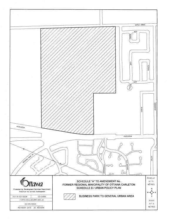
Amendment to redesignate lands at 6043 Hazeldean Road from Employee Area to
General Urban Area in the New City of Ottawa Official Plan, Business Park to
General Urban Area in the Regional Official Plan, and from General Industrial
and Highway Commercial to Residential, General Commercial, Highway Commercial
and Stittsville Mixed Use Area in the Goulbourn Official Plan as detailed in
Documents 2, 3, 4, 5 and 6.
RECOMMANDATION DU COMITÉ
Que le Conseil approuve et
d’adopter une modification du Plan officiel en vue de remplacer les
désignations des terrains situés au 6043, chemin Hazeldean comme suit : de
Secteur d’emploi à Secteur urbain général dans le Plan officiel de la nouvelle
Ville d’Ottawa; de Parc d’affaires à Secteur urbain général dans le Plan
directeur régional; d’Industriel général et de Commercial routier à
Résidentiel, Commercial général, Commercial routier et Secteur à utilisations
mixtes de Stittsville dans le Plan officiel de Goulbourn, comme il est précisé
dans les documents 2, 3, 4, 5 et 6.
Documentation
1. Development Services Department General Manager’s report dated 8 May 2003 (ACS2003-DEV-APR-0137).
2. An Extract of Draft Minutes, 12 June 2003, will be distributed prior to Council.
Report to/Rapport
au:
Planning and
Development Committee /
Comité de l’urbanisme et de l’aménagement
and Council/et au Conseil
08 May 2003 / le 08 mai 2003
Submitted by/Soumis par: Ned Lathrop, General Manager/Directeur général
Development Services Department
/ Services d’aménagement
Contact/Personne-ressource: Grant Lindsay, Manager, Development
Approvals / Gestionnaire, Approbation des demandes d’aménagement
580-2424 ext.
13242, grant.lindsay@ottawa.ca
|
Ref N°:
ACS2003-DEV-APR-0137 |
SUBJECT: OFFICIAL
PLAN AMENDMENT - 6043 HAZELDEAN ROAD
OBJET: MODIFICATION
DU PLAN OFFICIEL – 6043, CHEMIN HAZELDEAN
REPORT RECOMMENDATION
That the Planning and Development Committee recommend that Council approve and adopt an Official Plan Amendment to redesignate lands at 6043 Hazeldean Road from Employee Area to General Urban Area in the New City of Ottawa Official Plan, Business Park to General Urban Area in the Regional Official Plan, and from General Industrial and Highway Commercial to Residential, General Commercial, Highway Commercial and Stittsville Mixed Use Area in the Goulbourn Official Plan as detailed in Documents 2, 3, 4, 5 and 6.
RECOMMANDATION
DU RAPPORT
Que le Comité de l’urbanisme et de
l’aménagement recommande au Conseil d’approuver et d’adopter une modification
du Plan officiel en vue de remplacer les désignations des terrains situés au
6043, chemin Hazeldean comme suit : de Secteur d’emploi à Secteur urbain
général dans le Plan officiel de la nouvelle Ville d’Ottawa; de Parc d’affaires
à Secteur urbain général dans le Plan directeur régional; d’Industriel
général et de Commercial routier à Résidentiel, Commercial général,
Commercial routier et Secteur à utilisations mixtes de Stittsville dans le Plan
officiel de Goulbourn, comme il est précisé dans les documents 2, 3, 4, 5 et 6.
BACKGROUND
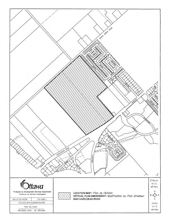
The subject Official Plan Amendment application applies to 6043 Hazeldean Road, former Township of Goulbourn, a location map is provided as Document 1. The property is 55.83 hectares in size and fronts on the north side of Hazeldean Road at the terminus of Main Street Stittsville. The site extends from Hazeldean Road north to the unopened road allowance of Maple Grove Road and is immediately west of, and adjacent to, the existing Bryanston Gate Subdivision. The northeast corner of the property coincides with the southwesterly corner of the Kanata West Concept Plan (KWCP) area.
The property is presently designated primarily General Industrial in the Goulbourn Official Plan with a small area of Highway Commercial, and Business Park in the Regional Official Plan. The new City of Ottawa Official Plan currently designates the property and the lands to the west as Employment Area, which in effect, carries over the existing designations. The property is zoned “MG-h” General Industrial Zone (with a holding designation). This zone permits a full range of automotive and industrial uses as well as service and restaurant uses. The holding designation was applied due to servicing issues.
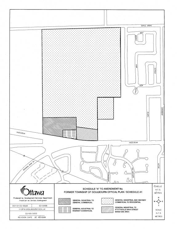
The Official Plan amendment application proposes to redesignate the property from General Industrial and Highway Commercial in the Goulbourn Official Plan to a combination of Residential, General Commercial, Highway Commercial and Main Street Mixed Use. The application also proposes to change the Business Park designation in the Regional Official Plan to General Urban Area. (See Documents 3 and 4). An equivalent change to the new City of Ottawa Official Plan will be required to change the designation from Employment Area to General Urban Area.
The applicants have also prepared a concept plan to indicate how the subdivision could be laid out within the respective land use designations. While this is not a prerequisite to the submission of an Official Plan amendment, it was included in the submission and became a focal point for discussion purposes for both the technical and public review. The approval of the concept plan does not give the concept plan an official status; it does however reflect the landowner’s intentions. The Official Plan amendment application will be followed later this year with a subdivision application and a rezoning application.
DISCUSSION
Industrial/Residential Need
The Economic Development section of the Goulbourn Official Plan lists one of its objectives as being “to improve the jobs to dwelling unit ratio in Stittsville”. The subject lands were, at the time of the formulation of the OP, considered a necessary component in Stittsville’s inventory of commercial and industrial designated lands to achieve a better live/work ratio. With Amendment #9 to the Regional Official Plan, which included 607 hectares known as the Kanata West Concept Plan (KWCP) area, into the urban area, a considerable amount of land is now available to provide employment opportunities to the west end of the City.
The original Kanata West Concept proposal envisaged 31,000 to 36,000 jobs. Since Amendment #9, however, the concept has been revised to now accommodate 25, 000 jobs in addition to 5,000 residential units. Even with this inclusion of residential uses within the concept area, it will be a challenge to meet the residential needs generated by these employment lands. In the staff KWCP staff report considered and approved by Planning and Development Committee (PDC) and Council in January of this year, staff noted that “in the Kanata-Stittsville area employment opportunities significantly exceed housing potential, due partly to the addition of KWBP”. Staff went on to recommend that the City launch a study to identify ways to redress the imbalance of housing and jobs. Possible policy responses are to include “…redesignations of urban employment lands for housing purposes.” During Planning and Development Committee’s consideration of the KWCP, Committee directed staff to “undertake a study to assess the housing demand and required residential land supply resulting from the employment numbers generated by the Kanata West Concept Plan….identify opportunities, as necessary, within the existing urban boundary to accommodate additional housing in locations accessible to Kanata West.” Conversion of the subject lands would appear to be in keeping with these staff recommendations and Council directives.
The Official Plan amendment was supported with a Needs Analysis. This study addressed the need for additional residential land in Stittsville and the implication of removing the lands from their existing industrial designation. Staff have reviewed this document and find the residential and employment demand calculations are generally in keeping with those generated for the preparation of the new City of Ottawa Official Plan and as such concur with it’s conclusions, “….redesignation of the subject land would help alleviate some of the pressure anticipated by housing growth over the coming decade”.
Site Location/Land Use Conflicts
As noted above, the land to the east of the subject lands is comprised of an existing single detached residential subdivision. The land is presently zoned and designated for general industrial purposes, this zoning and designation differs significantly from other industrially designated lands in Stittsville. The Stittsville Business Park (lands along the eastern boundary of Stittsville fronting on Iber Road) is designated Restricted Industrial and zoned Business Park Industrial. The Stittsville Business Park, similar to the subject lands, back on to an exiting residential subdivision. The uses permitted along Iber Road however, are considerably more restrictive than those under the existing designation on the subject lands. The Business Park Industrial zone doesn’t allow automotive uses, nor heavy equipment sales and service but does include “research and development facility”. Zoning on the subject lands, in contrast, permits a full range of automotive uses and heavy equipment sales and service. While land use conflicts with adjacent residential neighbourhoods have been minimized in the Stittsville Business Park area through careful site planning, it is anticipated that with an emphasis on “heavier” industrial uses on the subject lands, keeping land use conflicts to a minimum will be difficult. A change to residential uses, especially when they are anticipated to be of a similar form and density as the existing subdivision, will obviously result in a minimum of land use conflicts.
Natural Environment
The site contains both forests and wetlands. It drains partially to the Feedmill Creek subwatershed and partially to the Sawmill Creek subwatershed area both of which are within the Carp River watershed. No environmental designation for the protection of existing environmental features applies to these lands. Lands to the north are however shown as an “Environmental Feature” in the Regional Official Plan and are designated “Rural Natural Features Area” in the new City Official Plan. The Mississippi Valley Conservation Authority (MVCA) has indicated that there may be fish habitat concerns associated with the natural features on site.
The three wetland features on site are part of the Stittsville Wetland Complex which extends north to Highway 417. This wetland is not considered to be Provincially significant by the Ministry of Natural Resources. The portion of this wetland complex south of Hazeldean Road was removed as part of a residential development presently under construction. Much of the study area is part of the Stittsville North Natural Area as identified in the Regions’ Natural Environmental System Strategy. A watercourse transects the property in the northwest which is part of the headwaters of Feedmill Creek.
The landowners have developed an environmental strategy which is reflected in their concept plan. Their strategy focuses on three aspects of the site’s natural environment: Feedmill Creek, on site features and functions associated with the forest and wetland, and the impact on the adjacent natural feature to the north. The landowners have indicated their intention to preserve Feedmill Creek with a naturalized setback, and preserve portions of the marsh habitat surrounding the watercourse and a portion of the wetland area in the southeast corner immediately contiguous to the exiting Bryanston Gate Park. They are also proposing to locate a storm water pond adjacent to the watercourse with an artificial wetland and to centrally locate the parkland. This strategy is reflected in the concept plan. Locating the parkland and the storm water pond contiguous to the Feedmill Creek will serve to provide a greater opportunity for the preservation of tree cover on site. Coupled with the artificial wetland it will provide wetland habitat for existing wetland species and maintain the natural linkage to the Rural Natural Feature Area to the north.
It will be necessary for the applicants to support the subdivision application with a Tree Planting and Conservation Plan (ROP Section 5.2.1(4) ROP) and to indicate how the subdivision is “designed with nature” (ROP Section 5.2.3). As the site contains organic soil it will also be necessary at the next stage of planning approvals for the applicants to prove that the site is “suitable or can be made suitable for development” and that “alterations to the site will not cause adverse environmental effects”(ROP Section 11.3). Through the review of this additional information staff can further test the environmental strategy put forward by the applicants.
MVCA will also be conducting further site analysis to assess the onsite fish habitat. The applicants will be required to satisfy MVCA that the subdivision design and construction will not negatively impact fish habitat. If there are impacts, the applicants may be required to provide fish habitat compensation. Compensation may involve on site and/or off site works.
The subject site is within the study area of the ongoing Carp River Watershed Study. The results of this study are not yet available but are expected to be available this summer in advance of the subdivision application. It is expected that the watershed study will provide direction for the preparation of the Conceptual Storm water Site Management Plan.
Transportation
The subject property fronts onto Hazeldean Road, which is to be widened from Terry Fox Drive to Main Street Stittsville to arterial street standards with a roadway width of four lanes. The remainder of the Hazeldean Road frontage (west of Main Street) will be improved but will remain as two lanes. The northerly most boundary of the subject property is the unopened road allowance of Maple Grove Road. Maple Grove Road is presently open and assumed from Terry Fox Drive west to the westerly most local street in the Bryanston Gate Subdivision, Alon Street.
The landowners are proposing a collector road to extend north, as an extension of Main Street Stittsville, to link with a westerly extension of Maple Grove Road. This extension of Main Street is in keeping with the Kanata West Concept Plan which shows an extension of Palladium Drive extending west from Huntmar Drive and them curving south and terminating at the north end of the subject lands. The Main Street extension would link up with this Palladium Drive extension. Staff has expanded the Official Plan amendment proposal to include an amendment to the Transportation schedule for Stittsville contained within the Goulbourn Official Plan to show the addition of a collector road north from Stittsville Main Street to Maple Grove Road (See Document 5). This addition to the Official Plan amendment will ensure that the subdivision will incorporate this transportation requirement as part of the subdivision layout.
A traffic impact analysis of the proposed development was prepared and submitted in support of the Official Plan amendment. The analysis looked at the change in traffic volumes and change in traffic movement attributed to the anticipated alteration in land use and the adequacy of the existing and proposed transportation network in accommodating these changes. The report concluded that the change in land use designation would result, based on the full development of the lands, in a slight reduction (in total) in the number of trips related to the subject area, although the directional distribution would be different. The study concludes that the existing and planned capacities of the transportation are adequate to meet the forecast demand.
Johnwoods Street, the main north/south route, through the adjacent Bryanston Gate Subdivision presently experiences a great deal of cut through traffic especially related to the Corel Centre when major events are being held. Construction of a new north/south link from Hazeldean Road to Maple Grove is expected to significantly relieve this ongoing community concern.
The residents have raised a number of issues with respect to the proposal as it relates to transportation. Although it is generally agreed that the extension of Main Street will relieve the traffic on Johnwoods Street, concern was raised with the present condition of Maple Grove Road. A suggestion was made that the further extension north envisaged in the Kanata West Concept Plan be completed prior to proceeding with development on the site and/or to terminate the Main Street extension in a cul de sac until such time as the Huntmar extension is complete.
The timing and the details of the construction will be addressed in the next step of the planning process with the submission of the subdivision application. At this next stage the landowner will indicate the phasing scheme for the subdivision. It is anticipated that the development will build out in five to six years. Two or three phases are anticipated. As part of the review of the phasing scheme, staff will determine the appropriateness and timing of any connection to Maple Grove Road and if any off site road improvements are required.
Municipal Servicing
Being that the lands in question are within the village boundary, they are to be developed with full urban services. The primary infrastructure concern for these lands is the provision of sanitary services. The change from commercial to residential in this case, will not increase the total sanitary flows significantly but there will be a difference in the amount and time that the peak flow is reached. This land designation change will mean the peak sanitary flows will now coincide with those of the surrounding residential lands. As mentioned previously, the lands currently have a holding designation on the zoning due to servicing constraints. The constraint does not relate to a sewer capacity issue but is concerning the routing of the sanitary flows through the existing or proposed infrastructure to connect to the trunk outlet sewer.
Within the Village of Stittsville there are many pumping stations that are required due to the existing topography of the lands with respect to the elevation of the trunk outlet sewer. The staff is currently undertaking flow monitoring of the existing system in conjunction with the applicants consultant to determine the existing infrastructure capacities and arrive at the appropriate routing of the sanitary flows for these lands. Once this analysis has been completed and decisions made, the next steps of Subdivision and Rezoning approval can be completed.
As for the provision of water and storm services, there are no constraints currently indicated and through the next steps, the developer will provide the required studies and subsequent designs for the City to approve.
Residential Designation
The Official Plan amendment is
primarily proposing a residential designation. The concept plan shows a number
of crescents extending off of a central collector road. The original concept
proposal provided for 669 units, a combination of singles, semis and adult
lifestyle townhomes. Staff has asked that the residential mix more
appropriately reflect the residential mix and street pattern envisaged for
“Developing Communities” in the new City Official Plan. A suggestion was also
made at one of the informal public meetings that this subdivision would be an
appropriate location for apartment units, a much needed form and tenure of housing
in Stittsville. As a result of these comments the landowners have revised their
concept plan to incorporate two low rise apartment blocks, 1.6 ha and .8 ha in
size and a mixed use area along the Hazeldean
frontage. This latter block would allow commercial or medium to high density housing or a combination of both. The OPA schedule will reflect the proposed mix use area along the Hazeldean frontage. The residential designation will not indicate the housing type. The text of the amendment will however indicate that low rise apartments are anticipated as part of this development. The exact mix of housing types will be determined through the subdivision and zoning review processes.
Commercial Designations
The Official Plan amendment is proposing the introduction of a General Commercial designation along the Hazeldean frontage and a reallocation of the Highway Commercial designation from interior to the site to the proposed intersection of Hazeldean Road and the extension of Main Street. The commercial square footage, which could be accommodated on the General Commercial block, would place the development in a Neighbourhood Scale commercial cluster category in the Goulbourn Official Plan. Although this location and land size could accommodate a single use commercial development sufficient to accommodate a grocery store, staff is of the opinion that development at this site should be designed to meet the needs of the new neighborhood, as well as, the larger community. This should not be allowed to develop as a single use commercial area but rather a multi tenant building to provide a variety of retail and service uses. In keeping with the spirit of the new City Official Plan staff will be looking for a design to integrate it into the new neighborhood, as well as, take advantage of its location at the intersection of two major roads within the Village. The recommended text to the Official Plan amendment, found in Document 2, introduces area specific policies to ensure this is realized.
The Official Plan amendment is also proposing a Highway Commercial designation .6 ha in size at the intersection of Hazeldean Road and the Main Street extension. This is specifically aimed toward the construction of an automobile service station. Concern was raised by the public with the establishment of a service station at the entrance to a new community. Staff has reviewed the Goulbourn Official Plan, Regional Official Plan, the new City Official Plan (specifically the Main Street designation policies), and a study conducted in the former City of Kanata which determined the appropriate locations of automotive uses, in an effort to find direction as to the appropriateness of this use at this location. The Goulbourn Official Plan recognizes that highway commercial uses “cater to the needs of the traveling public” and “shall not adversely affect surrounding development” but is silent on their exact location vis a vis adjacent residential communities. Traditionally only neighbourhood commercial uses were approved interior to residential developments. This location is not interior to the site however but on the southern edge. The Main Street designation found in the new City Official Plan, which is to be applied along the existing Main Street corridor, does not expressly prohibit nor permit service stations. It provides design criteria to be met regardless of the land use which can be used as a guideline for the review of the design of all of the commercial blocks.
In those designations which have been applied to the lands
fronting on the existing Main Street, namely Stittsville Core Area and Main
Street Mixed Use Area automotive uses
are not listed as permitted uses. The Hazeldean Road corridor in contrast, is
primarily a Highway Commercial
designation. This designation includes automotive uses, and specifically includes “automobile service stations”. The subject Highway Commercial designation is being proposed at the intersection of Hazeldean and the extension of Main Street. The Highway Commercial designation reflects the traditional land use designations found along Hazeldean Road while the mixed use designation proposed for the northeast corner reflects the vision of Main Street. The General Commercial designation, which is proposed to the north and west, of the Highway Commercial designation permit land uses traditionally found on both Hazeldean Road and Main Street. Staff has concluded that the commercial and mixed use designations being proposed at the new intersection of Hazeldean Road and Main Street successfully merge the visions of both of the respective roadway corridors.
With a review of the former Kanata study on appropriate locations of automotive uses, this location would be considered to be appropriate as it is at the intersection of an arterial and a collector road providing service stations were not permitted on all four corners. In the subject situation, should the Official Plan amendment be approved, this newly proposed location would be the only corner where a service station could be permitted. The southeast corner presently is being developed for residential purposes, the southwest corner is designated residential and is presently owned by the Ottawa Carleton District School Board and zoned Institutional and the northeast corner is being proposed as a Stittsville Mixed Use Area designation. The designations which apply or are proposed to apply to the remaining three corners do not permit automobile uses. It should also be noted that the block being proposed for the Highway Commercial designation is of an equivalent size to that Highway Commercial area, interior to the site, which is proposed to be redesignated to residential.
One concern which staff share with the public is that of the appearance of this service station. Specific area policies are being proposed as part of the OPA to ensure that the design of the service station is appropriate for the entrance to this new residential community. These design considerations will be applied in part through the subdivision and zoning applications but in more detail in the review of the site plan applications that will be required prior to construction of any part of the commercial blocks.
CONCLUSIONS
The redesignation of land from industrial to residential
and commercial use will not have a detrimental impact on the availability of
employment lands in the area and will serve to address a possible shortfall in
the amount of residential land available close to the Kanata West Concept Plan.
This change in land use designation will also serve to dramatically reduce land
use conflicts with the existing residential neighbourhood that had been
anticipated with the development of the lands for general industrial uses. The
existing and anticipated transportation network will be adequate to meet the
demand generated from this development. The construction of Main Street through
to Maple Grove Road will be another means to assist in relieving the ongoing
problem raised by the public of cut through traffic on Johnwoods Street.
Although no
environmental protection designations in the Goulbourn Official Plan nor the Regional Official Plan apply to the lands, it is recognized that these lands contain a range of environmental features and functions which are highly valued by the neighbouring residents. Through careful design of the subdivision in the next stage of the planning process some of the natural features and functions of the site will be preserved. Finally it would appear, with careful attention to the design of the commercial blocks, the commercial designations being proposed are appropriate in their respective locations.
ENVIRONMENTAL IMPLICATIONS
The environmental implications of this proposal are discussed in detail elsewhere in this report. It is generally concluded that a residential land use will provide a greater opportunity to “Design with Nature” than will industrial uses. General Industrial developments are characterized by large lots large single use buildings with extensive area of paved surfacing to accommodate parking, truck storage and deliveries and outdoor storage. No parkland is provided as part of an industrial area.
Residential development in comparison has multiple small lots and blocks which can be laid out to incorporate natural features. Residential communities incorporate active and passive parkland which can provide the opportunity to incorporate existing trees and watercourses.
RURAL IMPLICATIONS
The subject proposal is located at the northerly most boundary of the Village of Stittsville. Land immediately adjacent to the north is outside the urban boundary as defined in the Regional and New City OP. These lands are considered an “Environmental Feature” in the Regional OP and a “Rural Natural Features Area” in the New City OP. The landowners have outlined in their environmental strategy and reflected in their concept plan the protection of the Feedmill Creek corridor and the provision of an artificial wetland as part of the stormwater management pond. This in turn maintains an environmental linkage with the rural environmental feature to the north.
CONSULTATION
In addition to the standard
notice requirements by the City, two informal public information meetings were
held. Concerns were raised about a number of issues by the neighboring
residents. Concern with the destruction of the natural features on site which
presently provide habitat for a variety of birds and animals. Other issues
raised were transportation and traffic, location and size of parkland,
requirements for blasting, and the establishment of additional commercial land
along Hazeldean Road. Interest was expressed with the type of residential units
which were being proposed immediately adjacent to existing residential
community and the need for a setback between the old and new residential
developments. The Stittsville Village Association also raised concern with
locating a service station at the entrance to this new community.
Greenspace Alliance submitted written comments indicating that due to the natural feature on site this land was inappropriate for development. Despite specific issues raised by the neighboring residents there was a general acknowledgement that residential uses are preferable over industrial for this area and that the extension of Main Street would assist in relieving the cut through traffic problem being experienced by Johnwoods Street residents.
The Ward Councilor is generally supportive of the application.
FINANCIAL IMPLICATIONS
N/A
APPLICATION PROCESS TIMELINE STATUS
The application was not processed within the timeframe established for the processing of Official Plan amendments. As there was extensive interest in the development proposals for these lands expressed by neighboring residents, the planning process has been delayed to provide an opportunity to hold two informal information meetings. This timeframe also provided an opportunity for the landowners to rethink some aspects of the proposals in light of the public comments expressed and have revised their original Official Plan amendment and concept plan accordingly.
ATTACHMENTS
Document 1 - Location Map
Document 2 – Proposed OPA text changes
Document 3 – City of Ottawa Official Plan Urban
Schedule
Document 4 – Regional Official Plan Urban
Schedule
Document 5 – Goulbourn Official Plan Land Use
Schedule
Document 6 – Goulbourn Official Plan Transportation
Schedule
DISPOSITION
Department of Corporate Services,
Secretariat Services to notify the owner (Taggart
Residential Developments Ltd., 708-225 Metcalfe Street, Ottawa ON K2P 1P9, the
Planner (Lloyd Phillips, Lloyd Phillips and Associates Ltd., 14 Woodlawn
Avenue, Ottawa ON K1S 2S9) and the Manager of Assessment, Department of
Corporate Services of City Council’s decision.
Development
Services Department to prepare the by-law adopting the
official plan amendment, forward to Legal Services Branch and undertake the
statutory notification.
Department
of Corporate Services, Legal Services Branch to
forward the by-law adopting the official plan amendment to City Council.
LOCATION MAP Document 1
PROPOSED
OPA TEXT CHANGES
Document
2
OFFICIAL PLAN AMENDMENT # 15
TO THE GOULBOURN OFFICIAL PLAN
6043 HAZELDEAN ROAD
STITTSVILLE
(TAGGART RESIDENTIAL DEVELOPMENT LANDS)
SPECIAL POLICIES
Residential Areas
1. A mix of housing types and densities should be provided in the development and residential development should provide opportunities for the accommodation of households of a variety of sizes and ages.
2. Public park areas should be contiguous with other open spaces such as Feedmill Creek and any proposed storm water management facilities and with Bryanston Gate Park to the south east. Park areas should be connected by a contiguous pedestrian path network formed by pedestrian paths and sidewalks on local streets.
3. Development of new residential areas adjacent to existing residential areas that front on Alon Street to the east shall provide adequate buffering in forms such as extra lot depth, fencing and landscaping.
4. Development of new residential areas adjacent to areas zoned for commercial or industrial uses should provide adequate buffering in the forms of extra lot depth, fencing and landscaping.
General Commercial Area
1. Development of the general commercial area shall be comprised of a building or buildings designed to accommodate multiple tenants. The zoning by-law shall provide for retail and service uses to meet the needs of the adjacent neighbourhood as well as that of the community at large.
2. Development in the general commercial area shall be designed as part of the neighbouring residential area, providing pedestrian connection where appropriate.
Urban Design
1. The design and development of commercial areas and commercial mixed use areas adjacent to Hazeldean Road shall have regard for the Stittsville Main Street Design Guidelines.
2 Entry features and other landmarks should be provided along the main north-south road. The design and placement of built forms, the entry features and landscaping should be configured to provide a sequence of views and variety of images along the street.
3. The design of the main north south road should provide for safe, barrier-free and conveniently located pedestrian crossings. This road should also be designed to accommodate transit service.
4. The design of the plan of subdivision shall provide for a system of convenient, barrier free pedestrian and cycling routes that connect to other existing and planned routes.
Environment
1. Feedmill Creek shall be protected by the provision of a naturalized corridor having a minimum width of 15.0 metres on each side, measured from normal high water mark.
2. The design and development of parks, storm water management systems and other open spaces shall give high priority to the conservation of existing trees and vegetation where feasible.
3. The design and development of residential areas, all commercial areas and mixed use areas should use opportunities to conserve existing tree cover and vegetation where feasible. Additional street trees, landscaping and vegetation shall be provided along the side and rear lot lines of residential and commercial developments.
NEW OFFICIAL PLAN URBAN SCHEDULE Document
3
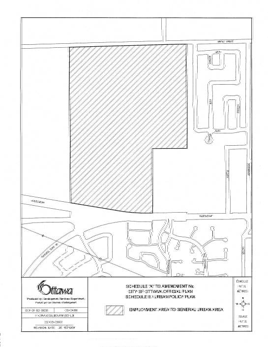
REGIONAL
OFFICIAL PLAN URBAN SCHEDULE Document 4
GOULBOURN
OFFICIAL PLAN LAND USE SCHEDULE Document
5
GOULBOURN OFFICIAL PLAN
TRANSPORTATION SCHEDULE Document
6