4. LEITRIM
COMMUNITY DESIGN PLAN, OFFICIAL PLAN AMENDMENT - CERTAIN LANDS IN LOTS 16, 17
AND 18 OF CONCESSIONS 4 AND 5 PLAN DE CONCEPTION
COMMUNAUTAIRE DE LEITRIM, MODIFICATION DU PLAN OFFICIEL - CERTAINS TERRAINS
FAISANT PARTIE DES LOTS 16, 17 ET 18 DES CONCESSIONS 4 ET 5 |
Committee RECOMMENDATIONS AS AMENDED
That Council:
1. Approve
the Leitrim Community Design Plan, as detailed in Document 6 (under separate
cover).
2. Adopt Official Plan Amendment No. XX
to the City of Ottawa Official Plan (2003), as detailed in Document 4, to
change certain lands on Schedule B within Leitrim from Employment Area to
General Urban Area as per the recommended land use plan in the Leitrim
Community Design Plan.
3.
Delete Subsection 5.4, C19 in its
entirety, which suggests appropriate parking standards for Mixed Use Centres,
to be replaced with the following paragraph:
Parking requirements in Mixed Use Centres: Reduced minimum and maximum parking ratios for retail, office
commercial and residential will be implemented at the time of zoning in
accordance with the new City of Ottawa Comprehensive Zoning By-law for lands
within the Core.
4.
Add
the following to Section 9.3 on Page 76 of the Leitrim Community Design Plan:
(c) A traffic impact statement is
required during the development review process for all future subdivisions
along Findlay Creek Drive. The
statement should investigate and consider traffic calming measures along
Findlay Creek Drive should they be warranted.
5.
The social housing component of the Leitrim Community Design Plan be at
least 7% of residential units (i.e. affordable to the 20% of households in
Ottawa that are lower income), subject to federal/provincial funding.
6.
Approve the following technical corrections, revisions and
inconsistencies to the final report of the Leitrim Community Design Plan;
a)
The phrase “with the opportunity for passive recreation uses such as
walking trails” be deleted from the subsection entitled “Transport Canada
Lands” in Section 6.1;
b)
Guideline C1 in Section 5.4
be revised so that it reads: “For each of the Mixed Use areas along Bank
Street, a composite site plan for the entire Mixed Use area must be approved prior to the first development
application for the area”; and
c)
The phrase “Official Plan’s
target for Leitrim is 5500 households” under the “Units” table in Section 4.3
and the sentence “The Official Plan directs that Leitrim will accommodate 5,500
households by 2021” in Section 2.1 be removed in their entirety;
d)
The number in the second
paragraph of Section 9.4 regarding the percentage of multiple-unit buildings in
Leitrim be changed from “45%” to “55%”; and
e)
The revisions identified on
the attached map, entitled “Revisions to Land Use Plan – June 28, 2005, Leitrim
Community Design Plan”, be made to the land use plan within the Leitrim
Community Design Plan.
RECOMMANDATIONS MOdifiée
DU COMITé
Que le Conseil :
1.
approuve le Plan de conception
communautaire de Leitrim, exposé dans le document 6 (document distinct).
2. adopte
la modification no XX au Plan officiel de la Ville d’Ottawa (2003),
énoncée dans le document 4 et visant à faire passer la désignation de certains
terrains énumérés à l’annexe B et situés à Leitrim de « secteur d’emploi »
à « zone urbaine générale », conformément au plan d’aménagement du
territoire recommandé dans le Plan de conception communautaire de Leitrim.
3. Supprime entièrement le sous-alinéa
5.4 C19 – qui suggère des normes appropriées de stationnement dans les centres
polyvalents – afin de le remplacer par le paragraphe suivant :
Exigences relatives au stationnement dans les centres polyvalents :
Des ratios minimaux et maximaux réduits seront mis en vigueur dans les zones de
commerces au détail, de bureaux et de commerces, et résidentielles au moment du
zonage, conformément au nouveau Règlement de zonage général de la Ville pour
les terrains du centre-ville.
4. Ajoute
le paragraphe suivant à l’alinéa 9.3 de la page 76 du Plan de conception communautaire de Leitrim :
(c) Une étude d’impact sur la circulation fera partie du
processus de révision de l’aménagement de tout futur lotissement le long de la promenade Findlay Creek. Celle-ci devra examiner l’opportunité
de prendre des mesures de modération de la circulation, le
cas échéant.
5. Que la composante « logement
social » du Plan de conception communautaire de Leitrim consiste en une
proportion d’au moins 7 % de logements résidentiels (c’est-à-dire qui sont
abordables aux 20 % de ménages d’Ottawa à faible revenu), sous réserve de
L’obtention d’un financement du gouvernement fédéral ou provincial.
6. Approuve les corrections de nature
technique et les révisions suivantes au rapport final du Plan de conception
communautaire de Leitrim :
a)
Suppression de la phrase « avec
l’occasion d’utilisations à des fins de détente comme les randonnées pédestres
sur les sentiers » du paragraphe intitulé « Terrains de Transports
Canada » de l’alinéa 6.1;
b)
Modification de la Ligne directrice
C1 de l’alinéa 5.4 pour qu’elle dise : « pour chaque zone à
utilisation polyvalente le long de la rue Bank, un plan composite d’ensemble
doit d’abord être approuvé avant qu’une demande d’aménagement pour la zone
puisse être faite; et
c)
Suppression des phrases
« l’objectif du Plan officiel pour Leitrim est de 5 500
ménages » sous le tableau « Logements » de l’alinéa 4.3 et
« Le Plan officiel indique que Leitrim accueillera 5 500 ménages dès
l’an 2021 » de l’alinéa 2.1;
d)
Modification, dans le deuxième
paragraphe de l’alinéa 9.4, de la proportion d’immeubles à plusieurs logements
de « 45 % » à « 55 % »; et
e)
Ajout des révisions figurant sur la
carte ci-jointe, intitulée « Révisions au Plan d’utilisation des terrains
– 28 juin 2005, Plan de conception communautaire de Leitrim », au plan
d’utilisation des terrains du Plan de conception communautaire.
Documentation
1.
Deputy City Manager, Planning and Growth Management report dated
7 June 2005 (ACS2005-PGM-POL-0017).
2. Extract
of Draft Minutes, 28 June 2005 will be distributed prior to Council.
Report to/Rapport au :
Planning and Environment Committee
Comité de l'urbanisme et de
l'environnement
and Council / et au Conseil
Submitted by/Soumis par : Ned Lathrop, Deputy City Manager/Directeur
municipal adjoint,
Planning and Growth Management/Urbanisme et Gestion de la croissance
Contact Person/Personne ressource : Richard
Kilstrom , Manager/Gestionnaire, Community Planning and Design
Division/Conception communautaire
Planning, Environment and Infrastructure
Policy/Politiques d’urbanisme, d’environnement et d’infrastructure
(613) 580-2424 x 22653,
Richard.Kilstrom@Ottawa.ca
REPORT RECOMMENDATIONS
That
the Planning and Environment Committee recommend that Council:
1. Approve the Leitrim Community Design Plan, as detailed in Document 6 (under separate cover).
2. Adopt Official Plan Amendment No. XX to the City of Ottawa Official Plan (2003), as detailed in Document 4, to change certain lands on Schedule B within Leitrim from Employment Area to General Urban Area as per the recommended land use plan in the Leitrim Community Design Plan.
RECOMMANDATIONS DU
RAPPORT
Que le Comité de l’urbanisme et de l’environnement
recommande au Conseil :
2.
D’approuver le Plan de conception
communautaire de Leitrim, exposé dans le document 6 (document distinct).
2. D’adopter
la modification no XX au Plan officiel de la Ville d’Ottawa (2003),
énoncée dans le document 4 et visant à faire passer la désignation de certains
terrains énumérés à l’annexe B et situés à Leitrim de « secteur d’emploi »
à « zone urbaine générale », conformément au plan d’aménagement du
territoire recommandé dans le Plan de conception communautaire de Leitrim.
EXECUTIVE SUMMARY
Assumptions
and Analysis:
Community Design Plans (CDP) are intended to
establish a community-wide land use framework that translates the principles,
objectives and policies of the Official Plan to the community-level. The CDP
provides guidance to the development approval process in order to allow
communities to develop over time in a coordinated manner. CDPs are required for all communities
designated as a Developing Community in the Official Plan, such as Leitrim, a
community of approximately 520 hectares located in the south end of the City of
Ottawa.
The Leitrim CDP was prepared through 2003, 2004 and 2005. The Leitrim CDP was completed with the
guidance of a technical advisory committee and undertook an extensive public
consultation process. Leitrim is
planned for approximately 15,000 residents, 5,300 residential dwelling units,
approximately 30,000 square metres of commercial floor space, and 7,000 jobs.
The Leitrim CDP contains:
· A land use plan that establishes the location of residential, commercial and institutional uses, and recreation uses;
· A set of design guidelines that directs the development review process;
· A greenspace plan that establishes the network of parks, trails and natural areas;
· A transportation network plan that establishes the road network and transit opportunities;
· A servicing plan that establishes the required municipal water, stormwater management and sanitary sewer infrastructure; and
· An implementation plan that establishes the strategy for such elements as develoment review, phasing, and amendments to the CDP.
Financial
Implications:
The development of major servicing infrastructure, parks and recreational trails within the Leitrim Community will be financed as per the new City of Ottawa Development Charges By-law.
Public
Consultation/Input:
Three public meetings were held as part of the Leitrim CDP, all held at the Fred Barrett Arena meeting hall. The first meeting in December 2003 was a design workshop where the basis of the Leitrim land use plan was established. The meetings in February 2004 and September 2004 were public meetings to gain feedback on the land use plan. All meetings were attended by a wide range of stakeholders. Notification for all three public meetings was through a combination of flyers, personal invitations, newspaper advertisements, a study mailing list, and the City’s website. All three draft reports of the Leitrim CDP (May 2004, November 2004 and March 2005) were available for viewing and the public was notified of their availability through the mailing list and the City's website.
RÉSUMÉ
Hypothèses et analyse :
Les plans de conception communautaire (PCC)
visent à établir, pour une collectivité particulière, un cadre d’aménagement du territoire reflétant les principes,
objectifs et politiques du Plan officiel au niveau communautaire. Les PCC
guident le processus d’approbation des demandes d’aménagement dans le but de
permettre aux collectivités de se développer d’une manière concertée. Chacune
des collectivités désignées comme « communauté en développement » dans le
Plan officiel doit avoir un plan de conception communautaire, ce qui est le cas
de Leitrim, collectivité d’une superficie approximative de 520 hectares située
à l’extrémité sud d’Ottawa.
L’élaboration du Plan de conception
communautaire de Leitrim s’est échelonnée sur la période de 2003 à 2005. Elle
s’est effectuée avec l’aide d’un comité consultatif technique et a également
donné lieu à de vastes consultations publiques. La collectivité de Leitrim a
été planifiée pour accueillir environ 15 000 résidents. Elle est censée
regrouper 5 300 unités d’habitation, des locaux commerciaux d’une
superficie d’environ 30 000 mètres carrés et 7 000 emplois.
Le PCC de Leitrim renferme les éléments
suivants :
- Un
plan d’aménagement du territoire définissant l’emplacement des
utilisations résidentielles, commerciales, institutionnelles et
récréatives.
- Des
lignes directrices de conception devant régir le processus d’examen des
demandes d’aménagement.
- Un
plan pour les espaces verts qui établit le réseau de parcs, de sentiers et
d’aires naturelles.
- Un
plan pour le réseau de transport qui établit le réseau routier et les
possibilités d’utilisation du transport en commun.
- Un
plan de viabilisation qui définit l’infrastructure municipale requise en
ce qui concerne l’aqueduc, la gestion des eaux pluviales et les égouts
séparatifs.
Un plan de mise en œuvre qui établit la
stratégie à adopter en ce qui concerne notamment l’examen des demandes
d’aménagement, l’échelonnement du développement et la modification du PCC.
Répercussions financières :
La mise en place de l’infrastructure
de services ainsi que l’établissement de parcs et de sentiers récréatifs dans
la collectivité de Leitrim seront financés conformément aux dispositions du
nouveau Règlement sur les redevances d’aménagement de la Ville d’Ottawa.
Consultation publique / commentaires :
Trois réunions publiques ont eu lieu
au cours de l’élaboration du PCC de Leitrim. Toutes se sont déroulées à la
salle de réunions de l’aréna Fred-Barrett. La première, en décembre 2003, était
un atelier de conception durant lequel on a jeté les bases du plan
d’aménagement du territoire de Leitrim. Les réunions de février et de septembre
2004 avaient pour but de connaître le point de vue de la population sur le plan
d’aménagement du territoire. Un large éventail d’intervenants ont assisté aux
réunions, qui avaient été annoncées au moyen de dépliants, d’invitations personnelles,
d’un avis collectif transmis aux personnes inscrites sur la liste d’envoi et
d’avis dans les quotidiens et sur le site Web de la Ville. La population a eu
la possibilité de consulter les trois rapports préliminaires sur le PCC de
Leitrim (mai et novembre 2004 et mars 2005), après avoir été avisée de leur
disponibilité au moyen de la liste d’envoi et du site Web de la Ville.
BACKGROUND
Community Design Plans are intended to translate the
direction and policies of the City of Ottawa Official Plan (2003), "the
Official Plan", to the community level, by establishing the land use
framework of principles, objectives and policies that will guide development
within the community. They are prepared
as policy plans operating between the policies of the Official Plan and the
development review process. The
Official Plan requires that a CDP be prepared for lands designated Developing
Community, a designation that overlies the majority of the Leitrim Community,
prior to development commencing. Given
the recent development applications together with the expressed interests for
development of several landowners within Leitrim, the completion of the Leitrim
CDP was necessary to ensure that the Community develops in a coordinated
manner.
The Leitrim CDP was initiated in November 2003 following City
Council's endorsement of the CDP's work program on October 22, 2003. The study was carried out throughout 2003,
2004 and 2005 by a multi-disciplinary consulting team led by The Planning
Partnership. The study was comprised of
three main components: land use and design, recreation, and
infrastructure. As per the Official
Plan's direction, the Leitrim CDP was undertaken with an open and collaborative
consultation process comprised of workshops, public meetings and advisory
committee meetings. The study was
guided by a Technical Advisory Committee comprised of City staff from various
groups, external technical agencies, provincial ministries, and representatives
of landowners with large landholdings within Leitrim.
This report seeks approval of the Leitrim CDP and the proposed Official Plan Amendment that will implement part of the recommendations of the Leitrim CDP. The approval of the Leitrim CDP is required in order to support the proposed Amendment.
DISCUSSION
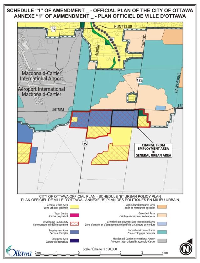
The Leitrim Community is an approximately 520 hectare
area located in the south end of the City of Ottawa (Document 1). Located to the southeast of the Macdonald
Cartier International Airport, the Leitrim Community is located entirely south
of Leitrim Road, generally between Bank Street and Albion Road. Some of the study area is located between
Albion Road and the existing rail corridor to the west and also east of Bank
Street north of Analdea Drive. The
Leitrim Wetland borders the Community to the southwest.
The majority of the Community is presently undeveloped. There are highway commercial and
institutional uses located along Bank Street, concentrated at the intersection
with Leitrim Road. A mixture of
residential, industrial and offices uses are located in the northwest corner of
the Community. Approximately 500 units
of Findlay Creek Village, a residential subdivision in the central area of the
Community, have been constructed based on previous approvals granted prior to
the adoption of the Official Plan.
The urban boundary for Leitrim as it appears on Schedule B of the
Official Plan was defined through several decisions throughout the 1990s. Leitrim was designated as an urban area in
June 1990 through the approval of OPA #10 to the City of Gloucester Official
Plan which redesignated the Community from a Rural Policy Area to an Urban
Policy Area. Subsequent to this
approval, the land use concept plan within OPA #10 was revised to account for
the presence of the Leitrim Wetland on lands owned by Tartan Development
Corporation. The final boundary for the
Leitrim Wetland and the limit of development on Tartan's lands was defined in
the field by the Ministry of Natural Resources, Tartan and a naturalist group
in December 1991 and the revised concept plan was approved by the Region in
November 1992 through the approval of Official Plan Amendment #1 to the new
Gloucester Official Plan. The urban
boundary for Leitrim was further expanded to include lands adjacent to the south
owned by the Remer Holding Corporation.
This expansion was the result of an Ontario Municipal Board (OMB) order
in 1994 regarding referrals of the 1988 Regional Official Plan. The boundary of the Leitrim Wetland and a
120-metre buffer on the Remer property was defined in the field as part of the
OMB decision. The boundary of the Leitrim Wetland on both the Tartan and Remer
properties, as per the above two decisions, was identified in the 1997 Regional
Official Plan and was reconfirmed in the Official Plan. These decisions established the limit of
development for both the Tartan and Remer lands.
The Leitrim CDP was initiated in order to provide a new land use
vision for Leitrim based on the new direction and policies of the Official
Plan. The CDP itself is not a statutory
document approved by Council as a secondary plan, but will be approved by
Council as a policy plan that guides development within Leitrim. The CDP is comprised of the following six
main components: the land use plan, the community design guidelines, the
greenspace plan, the transportation network plan, the servicing plan, and the
implementation plan.
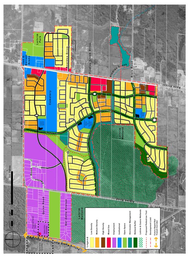
Land Use Plan
The land use plan (Document 2) was prepared based on the
consideration of the area’s existing conditions, transportation and servicing
considerations, the Official Plan’s direction, and input from the community and
key stakeholders. The framework for the
land use plan was derived from the discussion and evaluation of the three alternative
land use concept plans that were developed at the December 2003 workshop.
The land use plan is comprised of ten residential neighbourhoods,
three mixed-use centres along Bank Street, and employment lands in the
northwest corner of the area. The CDP
projects an ultimate population of approximately 15,000 residents within
Leitrim, with approximately 5,300 dwelling units, 7,000 total jobs, and 30,000
square metres of commercial retail floor space. The land use plan is organized around eight structuring elements,
as follows:
(1) Greenspace:
Leitrim is designed around its greenspaces. The Leitrim Wetland is incorporated into the design of the community through single loaded roads and viewlines and parks are designed as open and accessible features with open frontages and pedestrian and trail connections.
(2) Streets:
Leitrim is organized around a road hierarchy of key "spine" streets that connect the community and a modified grid system of local streets that connect neighbourhoods. Streets are to be designed as an integral part of the public realm, with considerations for lighting and landscaping. The street network has an emphasis on single-loaded roads along arterial roads to act as "window streets" into the community, particularly along Bank Street which is designated a Scenic Entry Route in the Official Plan.
(3) Transit:
Leitrim's connected road network provides accessibility to bus routes that will connect to the future location of the light rail transit station and park & ride lot.
(4) Mixed-Use Centres:
Leitrim is planned with three mixed-use centres along Bank Street to act as focal points that will accommodate a wide range of commercial, institutional, residential, and service uses. They are to be designed with attention to the CDP's design guidelines that speak to such elements as building setbacks, parking and landscaping.
(5) Schools:
Leitrim is planned with four elementary school sites that are focal points, all of which are located along the main north-south "spine" road. Schools are to be designed as “landmark” buildings.
(6) Higher Density Residential:
Leitrim will have its highest density residential uses surrounding focal points within the community to reinforce these uses, such as mixed-use centres or surrounding parks.
(7) Neighbourhoods:
Leitrim is organized into ten neighbourhoods, each with a clear focus such as a neighbourhood park, with a clear edge such as a collector road, and planned with a range of dwelling unit types.
(8) Employment:
Leitrim is planned with a sufficient amount of land for employment-generating uses to fulfill the Official Plan's direction for a balance between housing and employment. These employment uses are focused in the employment area in the northwest corner, but also are contained in the mixed-use and institutional sites throughout Leitrim.
The land use plan within the Leitrim CDP has eight land use
designations, which are described below.
The Low Density Residential designation comprises the majority of
the land within the residential neighbourhoods. This designation is intended to accommodate the majority of the
lowest density residential uses, primarily single detached and semi-detached
dwellings. Approximately 3,000 dwelling
units, or 56% of Leitrim's total units, will be accommodated within areas designated
Low Density Residential.
The Medium Density Residential designation is concentrated around
the community focal points, such as the mixed-use centres, around neighbourhood
parks, or along collector streets. The
Medium Density Residential designation will accommodate the majority of the
ground-oriented multiple unit dwellings, primarily street townhouses and
stacked townhouses. Approximately 2,000
dwelling units, or 34% of Leitrim's total units, will be accommodated within
areas designated Medium Density Residential.
The High Density Residential designation is concentrated around the
three mixed-use cores within Leitrim.
The designation will accommodate the majority of the highest density
residential uses, including low-rise and mid-rise apartment buildings and also
stacked townhouse units provided that density targets are met. This designation will accommodate
approximately 500 dwelling units, or 10% of Leitrim's total units.
The Mixed Use designation is concentrated in three "core"
areas along the west side of Bank Street but also with a small portion along
the east side of Bank Street. The
designation will accommodate a wide range of institutional, community and
convenience retail and personal service business uses. Higher density residential uses, such as
apartments, are also permitted to provide diversity in the housing stock. The areas designated Mixed Use will contain
approximately 30,000 square metres of commercial retail space, approximately 80%
of which will be in the three core areas.
The Employment designation applies to lands within the northwest
corner of the study area, which coincides with the existing employment areas on
Del Zotto Avenue, Leitrim Road, and Fenton Road, and also the undeveloped areas
south of Leitrim Road. The designation
will accommodate employment opportunities within the Community for a range of
office and industrial uses, with good access to the arterial road network and
the future light rail transit line, and will be developed in a high quality
business park setting. Lands designated
Employment will accommodate approximately 75% of the total number of jobs
within Leitrim.
The Institutional designation applies to both existing institutional
uses, such as the community centre, Police station, or cemetery near the
Leitrim Road and Bank Street intersection, as well new areas for school sites
and other new institutional uses. The
designation will accommodate a broad range of government, service and community
facilities within Leitrim.
The Open Space designation applies to a range of parks and natural
areas throughout Leitrim, including the existing district-level Leitrim Park,
two new community-level parks, eleven new neighbourhood-level parks, and the
large wooded area west of Albion Road.
There is approximately 54 hectares of greenspace provided in the land
use plan, consisting of both parks and natural areas parks and wooded
areas. The designation will accommodate
a range of recreational opportunities, from more active and structured uses
such as sports fields to more passive and informal uses such as public trails.
The Stormwater Management designation applies to the stormwater
management ponds and corridors within the Community that service development
within Leitrim. There are two
stormwater management ponds to service the Community: a main pond east of Bank
Street and north of Blais Road that services the majority of the Community and
smaller pond adjacent to the Employment area in the northwest corner of the
study area to service that area.
Additionally, there is a corridor along the northern edge of the Leitrim
Wetlands and along Findlay Creek Drive that is designated Stormwater
Management.
The Wetland Buffer designation reflects the Ontario Municipal Board
decision regarding the Leitrim Wetland and buffer area on the Remer lands. The land will be left in its natural state,
with the exception of the future public trails.
Design Guidelines
The design guidelines provide specific direction regarding the
design of Leitrim by identifying how the principles and objectives of the
Official Plan will be translated to the community level. They will provide specific guidance to the
development review process and subdivision and site plan applications. These guidelines are organized by the eight
structuring elements identified above.
Generally, the design guidelines direct the design of:
All buildings
regarding orientation, façade treatment, size, and coverage
Commercial
parking areas and internal streets within regarding orientation, location,
landscaping, screening, and standards
Streets regarding
tree planting, landscaping, lighting, and signage
Neighbourhood and
community parks regarding configuration, orientation and uses
Stormwater
management ponds and corridors regarding landscaping, and access
Public trails
regarding signage and amenities
All collector
streets, local streets and lanes regarding standards
Transit shelters
and waiting areas
All schools
regarding orientatio, façade treatment, parking, drop-offs, and access
Greenspace Plan
The greenspace plan identifies the network of parks, natural
features, stormwater management facilities, and public trails proposed for the
Leitrim Community. The Leitrim CDP
meets the Official Plan's targets for greenspace with approximately 80 hectares
of total greenspace (5.5 hectares per 1,000 people) and 37 hectares of parkland
(2.5 hectares per 1,000 people). The
greenspace network is comprised of the following elements:
(1) District-level Park
The existing district-level Leitrim Park that contains several sports fields and accommodates recreation needs for the larger area.
(2) Community-level Parks
Two new community-level parks located along collector streets will provide the majority of new sports fields and facilities within Leitrim.
(3) Neighbourhood-level Parks
Eleven new neighbourhood parks distributed throughout Leitrim to serve the immediate needs of the surrounding residents.
(4) Stormwater Management Areas
Two stormwater management ponds to be designed as community amenities with a stormwater management corridor to provide a linkage function
(5) Natural Areas
The wooded area west of Albion Road that is intended to be preserved in its natural state.
Transportation Network
Plan
The transportation network plan identifies the recommended network
of arterial, collector and local roads within Leitrim. The Official Plan and Transportation Master
Plan provides the direction to the Leitrim CDP regarding the surrounding
arterial road network. Bank Street and
Albion Road are planned to be ultimately four-lane arterial roads, while
Leitrim Road and the extension of Earl Armstrong Drive south of the Community
are to be two-lane arterial roads. The
road network of collector and local roads within Leitrim is based on a modified
grid system of roads. The collector
roads are "spine roads" and are the basis of the road network's
structure, while local roads are to be connected frequently with these
collector roads to provide permeability of movement.
The assessment of the road network from a transportation and traffic
perspective confirmed that there is sufficient capacity in the proposed road
network to accommodate the projected internal and external traffic volumes,
without additional works to those already identified in the Transportation
Master Plan. Public transit has a high
level of access and routing options, the modified grid pattern provides good
pedestrian access, and the commercial centres are readily served by the road
network. The transportation network
within the Leitrim CDP is consistent with the Official Plan's objective of
increasing the overall peak-hour transit modal split to 30%.
In terms of rapid transit to the Community, the Leitrim CDP defers
to the Environmental Assessment (EA) Study for the North-South Light Rail Project
which is scheduled to be completed in September 2005. A light rail transit station and Park & Ride lot, with
capacity for between 1,200 and 2,000 vehicles depending on its location, will
likely be located in Leitrim in proximity to the intersection of the rail line
with Albion Road. Two sites are
currently being presented as options, one on either side of Albion Road. Both sites as options have been incorporated
into the land use plan.
Servicing Plan
The servicing plan is based on the “Leitrim Community Design Plan
Serviceability Report” by Cumming Cockburn Limited, that is submitted under
separate cover to the Leitrim CDP. This
report describes the recommended water servicing, sanitary servicing, and storm
servicing schemes for servicing development in Leitrim. The report essentially consolidates and
updates all of the existing studies that have been done for the area in general
and for specific properties.
Sanitary
With the exception of small pockets of existing development, Leitrim
will be serviced by the Leitrim pumping station on Findlay Creek Drive just
west of Bank Street, which outlets to the Conroy Road Collector sewer through a
forcemain in Bank Street. The pumping
station, forcemain and gravity outlet sewer were all constructed in 2001 to
service the first phases of Findlay Creek Village. As build out occurs, detailed flow monitoring of the Leitrim
pumping station is required to confirm the design assumptions used in the
servicing analysis and to determine if any additional infrastructure upgrades
are required for ultimate build-out of Leitrim.
Water Supply
The
new Ottawa South Reservoir and Pumping Station and transmission main was
completed in 2002, connecting to the Leitrim Community at Leitrim Road and
Albion Road. This will ultimately
become the primary source of supply for the entire Community. Given the distance between the ultimate
water and wastewater servicing locations, the report recommends that the
primary source of water for the initial phases of development be the existing
watermain in Bank Street. Hydraulic
analysis suggests that this source can support the demands of the first phases
of development without compromising the City’s basic level of service
requirements. However, at some point a
secondary water feed must be provided through extension of a watermain north to
Leitrim Road or westerly to Albion Road.
Detailed hydraulic modeling of the proposed water distribution system
required to support the Community's development is broken into five distinct
phases to illustrate potential interim servicing and looping requirements to
support phasing. The South Gloucester
Pumping Station cannot be decommissioned until the watermain in Leitrim Road
west of Albion Road and the watermain in Albion Road south of Leitrim Road are
twinned, and also until a secondary feed is provided to the first phases of
development.
Stormwater Management
A description of the evolution of the stormwater management plans
for Leitrim is in Document 3. A
stormwater management facility located on the east side of Bank Street will
service the majority of development in Leitrim. Through an early servicing agreement with this property's land
owner and the developer, that facility is currently scheduled for construction
in 2005. A second smaller pond is also
required in the northwest area of Leitrim to service the employment lands and
residential lands north of the cemetery.
A temporary stormwater management facility has been constructed to
service the first phases of development in Leitrim, which will be
decommissioned once the main stormwater management facility is operating.
Implementation Plan
The implementation plan identifies how the vision of the Leitrim CDP
will be achieved, in terms of interpreting the CDP, the phasing of development,
guidelines for development review, targets for affordable housing and the
process for making future changes to the CDP.
Leitrim will generally develop from east to west from Bank Street, the
present location of sanitary trunk services.
The land use plan is divided into five residential zones with details of
the number and mix of dwelling units.
Residential densities and the mix of dwelling types will be reviewed in
development applications to ensure that the CDP's targets are achieved at both
the community and neighbourhood levels.
Densities and the mix of dwelling units will be monitored through the
City’s GIS system. The Leitrim CDP will
be primarily implemented through implementing zoning by-laws, plans of
subdivision, and site plan control. The
CDP's design guidelines provide direction to staff and applicants during the
development review process. The Leitrim
CDP follows the policies of the Official Plan by promoting the target of 25% of
all dwelling units as affordable units, which includes 5% of all dwelling units
as social housing units.
As part of the plan for implementation, an Official Plan Amendment
(Document 4) is being proposed by City staff to implement part of the
recommendations of the Leitrim CDP. The
Amendment proposes to change the designation on certain properties along
Leitrim Road, Bank Street and Analdea Drive from Employment Area to General
Urban Area. The Amendment affects
approximately 110 hectares within the Community and is being proposed by staff
to match the recommended land use plan of the Leitrim CDP. This Amendment is being recommended since it
provides a more appropriate balance of job and housing in Leitrim, it makes the
most appropriate use of urban land currently within the Community, and it
provides for the best design of the community by integrating the north and
south portions of Leitrim.
The Gloucester Official Plan and Regional Official Plan are still in effect given that the new Official Plan is presently under appeal. The Leitrim CDP, however, was prepared based on the direction of the new Official Plan, and does not reflect the policies of the Gloucester or Regional Official Plans. Amendments to the Gloucester and Regional Official Plans are not proposed at this time to implement the new CDP since it is anticipated that appeals to the Official Plan will be dealt with prior to development approvals within the area affected by the Leitrim CDP. Should amendments to the Gloucester and Regional Official Plans become necessary in order to support applications for development that are in compliance with the approved Leitrim CDP, they will proceed on an as-required basis. If any policies of the Official Plan fundamentally change as a result of the current appeals, City staff will bring to the Planning and Environment Committee a report recommending any required changes to the CDP.
ENVIRONMENTAL IMPLICATIONS
Several issues regarding the natural environment were
considered throughout the process for the Leitrim CDP.
Wetlands
Leitrim Wetland
The Leitrim Wetland borders the southwest boundary of the Leitrim
Community. A “fen” type of wetland
that is approximately 300 hectares in size, the Leitrim Wetland is rich in
plant and animal life, containing a range of significant plant species and a
variety of birds, mammals, fishes, amphibians, and insects. The Leitrim Wetland was evaluated as a Class
1, provincially significant wetland in October 1989.
The boundary of the Leitrim Wetland and the limit of development
within the Leitrim Community were established throughout the early 1990s, as
described in previous sections of the report.
In 1991, the final wetland boundary on the Tartan lands was flagged in
the field and agreed upon by Tartan, MNR and a naturalist group, and was
approved by the City of Gloucester and the Region in a 1992 Official Plan
Amendment to the Gloucester Official Plan.
As per confirmation from the Ministry of Natural Resources, this
boundary reflects the limit of development on the Tartan lands. In 1994, the wetland boundary on the Remer lands
and a 120-metre buffer along the eastern edge of this boundary were established
by the OMB. This decision defined the
eastern edge of the 120-metre buffer as the limit of development on the Remer
lands.
"Casino Wetland"
The "Casino Wetland" is located adjacent to the southern
boundary of the Leitrim, outside of the urban area. While the development limit for the Remer lands as determined by
the OMB physically severs the "Casino Wetland" from the main body of
the Leitrim Wetland, it remains designated as Significant Wetlands in the
Official Plan. Environmental studies
in support of development applications will have to have regard for this
provincially significant status. The
Leitrim is recommending that a physical connection between the "Casino Wetland"
and the Leitrim Wetland be preserved as part of the development approval
process.
Other Wetlands
The
work program for the Leitrim CDP included considering complexing other
surrounding wetlands with the Leitrim Wetland.
Two unevaluated wetland areas were identified for consideration during
the CDP process: the first located between Quinn Road and Del Zotto Avenue
within the urban area of Leitrim (the "Transport Canada site"); the
second located east of the Rideau-Carleton Raceway and north of Rideau Road,
outside of the urban area (the "Raceway Wetland"). Jacques Whitford Environment Limited (JWL)
was retained by the City to assess complexing these areas with the Leitrim
Wetland. This assessment concluded:
(a) Complexing the Transport Canada site with
the Leitrim Wetland is not recommended given that it appears to have little or
no wetland features or functions that would warrant complexing, however, the property represents a natural
linkage area between the Leitrim Wetland to the south and natural areas to the
north of Leitrim Road, and should be designated as such.
(b) Complexing the Raceway Wetland with the
Leitrim Wetland is warranted as there are a number of wetland features and
functions on the site.
From these recommendations, the Transport Canada site is designated
as Open Space in the Leitrim CDP and is to be preserved in its natural state,
while a full evaluation of the Raceway Wetland, which applies the Ministry of
Natural Resources Wetland Evaluation System, will be carried out in 2005 to
confirm the wetland’s boundary and its significance. The evaluation of the Raceway Wetland has no implications on the
Leitrim CDP.
Urban Natural Areas
Environmental Evaluation Study
The City is currently undertaking an Urban Natural Areas Environmental
Evaluation Study (UNAEES) as part of the Greenspace Master Plan. The Study's objective is to identify
woodlands, wetlands and ravines throughout the urban area that are worthy of
protection. The Study will establish
the relative environmental values of natural features, develop evaluation
criteria, establish priorities for protection, and propose recommendations for
management of urban natural features in consultation with the public. Four sites in Leitrim have been identified
by the UNAEES, all of which were unevaluated and are considered candidate
sites. “Site 105” is located on the
west side of Albion Road between Del Zotto Road and Quinn Road (described in
the above section). “Site 106” is
located on the east side of Albion Road south of the Fenton Road industrial
park “Site 107” is located immediately
south of Leitrim Road, between Albion Road and Bank Street. “Site 108” is located adjacent to Bank
Street, between Findlay Creek and the extension of Blais Road. Environmental impact statements for all four
sites will be required as part of the development approval process.
Furthermore, staff will be proposing to redesignate the wetland buffer on the Remer lands to Urban Natural Feature as part of the UNAEES strategy. The Official Plan Amendment for this redesignation will be brought forward to Planning and Environment Committee by staff in the fall of 2005.
The study area only includes lands within the urban boundary on Schedule B of the Official Plan. The Leitrim CDP does give consideration to rural lands adjacent to the urban boundary through conceptual road linkages should a boundary expansion be warranted in the future.
CONSULTATION
Three public meeting were held as part of the public
consultation process for the Leitrim CDP, all held at the Fred Barrett Arena
meeting hall. The meetings was attended
by a wide range of participants, including the consulting team, City staff, members
of the Technical Advisory Committee, developers, landowners, school board
representatives, business owners, interest groups, and residents. Notification for the public meetings was
through a combination of flyers, personal invitations, newspaper advertisements,
a study mailing list, and the City’s website.
For notification of the initiation of the study and for invitation to
the first workshop, a notice was put in The News South on November 21, 2003, a
flyer was distributed to Leitrim and the surrounding arena by Canada Post
between November 22nd and 25th, and the notice was put on the City's
"Public Consultation" website.
Following the first workshop, notification was undertaken through the
study's mailing and list and the City's website.
A design workshop was held on December 1 and 2, 2003 to present the
report of existing conditions and background information, to establish key
planning and design principles, and to develop three alternative land use
concept plans. A public meeting was
held on February 23, 2004 to evaluate the various components of the refined
alternative concept plans developed at the design workshop and to articulate
the key components of the community structure for the preferred land use
plan. A public meeting was held on September
23, 2004 to review the draft version of the Leitrim CDP report and to discuss
the relocation of stormwater management facilities and its effects on preferred
land use plan. Approximately 75
participants attended the design workshop in December 2003, while approximately
50 participants each attended the February 2004 and September 2004 public
meetings.
A Technical Advisory Committee (TAC) was established at the outset
of the Leitrim CDP to provide guidance to the consulting team during each stage
of the study. The TAC included
representatives from different City departments, provincial ministries,
conservation authorities, and landowners with large landholdings in the study
area. Five TAC meeting were held during
the study: three as part of the public meetings identified above, one on November
6, 2003 and one on June 22, 2004.
The three draft reports of the Leitrim CDP (May 2004, November 2004
and March 2005) were available for viewing and the public was notified of their
availability through the mailing list and the City's website. Throughout the various stages of the study,
several comments were received from the public. A summary of these comments and how they are addressed in the
Leitrim CDP is detailed in Document 3.
The notification for the proposd Official Plan Amendment in Document
4 was carried out in accordance with the Public Notification and Public
Consultation Policy approved by City Council for Official Plan Amendments. Given the size of the area and number of
properties affected, landowners were notified of the proposed Official Plan
Amendment by letters mailed through Canada Post. Through the notification process, only one comment was received,
which is addressed in Document 3.
Councillor Deans has been involved throughout the Leitrim CDP's process.
FINANCIAL IMPLICATIONS
The development of major servicing infrastructure, parks and recreational trails within the Leitrim Community will be financed as per the new City of Ottawa Development Charges By-law.
SUPPORTING DOCUMENTATION
Document 1 - Leitrim CDP Study Area Map
Document
2 - Land Use Plan within the Leitrim CDP
Document
3 - Summary of Public Comments
Document
4 - Official Plan Amendment No. XX
Document
5 - Public facilities in Leitrim
Document 6 - Leitrim Community Design Plan (distributed under separate cover and on file with the City Clerk)
DISPOSITION
1. Department
of Corporate Services, Secretariat Services to forward the Leitrim Community
Design Plan to Council for approval prior to its approval of the related Official
Plan Amendment.
2. Department
of Corporate Services to forward the implementing by-law to City Council.
3. Planning
and Growth Management Department to issue the Notice of Decision within the 20
day appeal period for Official Plan Amendment No. XX.
4. Planning
and Growth Management Department, through the next general update of Official Plan, to:
(a) Revise Annex 3 to the Official Plan to
indicate that Leitrim is subject to a Community Design Plan; and
(b) Revise Schedule B of the Official Plan to remove the Developing Community overlay designation from the Leitrim Community.
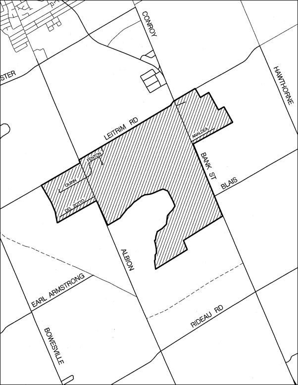
LEITRIM CDP STUDY AREA MAP Document 1

LAND USE PLAN WITHIN LEITRIM CDP Document 2
SUMMARY OF PUBLIC COMMENTS Document 3
The following is a summary of the key comments that were submitted at the three public meetings (December 2003, February 2004, September 2004) and throughout the process of the Leitrim Community Design Plan.
Comment: Why is development being permitted so close to a former waste site?
Response: The former Gloucester Landfill site served as a municipal waste disposal
site from approximately 1957 to its closure in 1980, with a portion of the site
used for the disposal of waste from Federal Departments and other public
institutions. Numerous studies and
assessments have been completed in the last 25 years to assess impacts of the
landfill site within the area. A
groundwater treatment facility was constructed and was operational beginning in
1992 with a number of extraction wells and there is a monitoring program in
place to monitor groundwater quality.
The "Area-Wide Risk Assessment" (AWRA), the most recent study
regarding the former landfill site, was undertaken to assess the likelihood of
effects on human or ecological health and to update previous studies. As part of the AWRA, a Supplemental Risk
Assessment was conducted for development east of Albion Road within Leitrim to
ensure the development is safe from past activities of Gloucester Landfill
site. The conclusion of the AWRA, as it
concerns the Leitrim CDP, is that "Environmental conditions associated
with the Gloucester Landfill site do not represent either a human health or
ecological risk to current and future land uses." Staff from several City departments have
been involved with the AWRA process and concur with the findings of the
study. This conclusion is one of the
'givens' of the Leitrim CDP.
Comment: Why did the Leitrim CDP exclude
certain lands surrounding the Urban Area?
Response: As per the terms of reference for the study, the Leitrim CDP used the
urban boundary from Schedule B of the Official Plan as the limit of the study
area. The present urban boundary for
Leitrim was established by 1994 and was indicated in the Gloucester and
Regional Official Plans and was reconfirmed in the Official Plan. The Leitrim CDP did consider lands
surrounding the Leitrim urban boundary in terms of road connections for
potential future expansions of the urban boundary surrounding the Leitrim
Community.
Comment: The
actual boundary of the Leitrim Wetland is larger than shown it is shown on the
land use plan in the Leitrim CDP.
Response: The Leitrim CDP uses the urban boundary as the study area, as shown on
Schedule B of the Official Plan. This
boundary was established by 1994 and is one of the ‘givens’ of the Leitrim
CDP.
Comment: There
should be high density residential development around the light rail transit
station.
Response: The light rail rapid transit line forms the western boundary of the
Leitrim Community, west of Albion Road.
The lands closest to the likely light rail station at the intersection
of the rapid transit line and Leitrim Road, on both sides of Albion Road, are
designated Employment given the restrictions associated with the Airport
Operating Influence Zone, which prohibits noise sensitive uses. The closest lands designated residential are
located approximately 1,000 metres from the transit station, well above the
Official Plan’s target of locating high density development within 400 metres
of transit stations. Transit within the
Leitrim Community will operate primarily through “feeder” bus routes that
connect to the future Leitrim station.
The highest density residential uses have been planned within the three
mixed-use centres which are located along these potential bus routes.
Comment: Why was a subwatershed study
not completed together with the Leitrim Community Design Plan?
Response: A subwatershed study generally examines the conditions of watercourses, groundwater resources, and natural habitat within a subwatershed. It identifies the significant natural features and linkages within the subwatershed, potential impacts of existing and future land use activities, measures for the mitigation of impacts, and opportunities for preservation. Several decisions have been made regarding certain environmental issues within the Leitrim Community, such as wetland boundaries, while many environmental studies and reports have been completed over that last 15 years in support of development applications. In establishing the work program for the Leitrim CDP, City staff did not feel it was necessary to duplicate the extensive work and decisions that had already been completed, but instead that the existing studies and information could be consolidated and augmented by assessments of areas not previously studied, such as through the Urban Natural Areas Environmental Evaluation Study. This approach was endorsed by the City Council in its approval of the work program and work schedule on October 22, 2003.
Comment: Will
there be sufficient commercial uses to serve the Leitrim Community?
Response: The Leitrim CDP identifies three mixed-use centres along Bank Street
that will accommodate the majority of Leitrim’s commercial uses. The first is located near the intersection
of Leitrim Road and Bank Street; the second on Findlay Creek Drive; and the
third on the future westerly extension of the Blais Road. These mixed use centre are planned to
contain approximately 30,000 square metres of the commercial floor space, the
majority of which will be located at the mixed-use centre along Findlay Creek
Drive. These areas will contain a broad
range of uses, including retail commercial uses, office uses and personal
services uses. The amount of commercial
space is sufficient for a community the scale of Leitrim and is consistent with
other ‘greenfield’ communities.
Comment: Are daycares and places of
worships identified on the land use plan?
Response: Specific locations for daycares and places of worship have not
been identified on the land use plan, in order to maintain flexibility, to
prevent unnecessary future amendments should the indicated sites not be used,
or should additional sites in Leitrim be warranted. Daycares, as a “generally permitted use” from Section 3.1 of the
Official Plan, are permitted in every designation that permits development
within Leitrim, subject to zoning and site plan control approval. Places of worship are permitted on lands
designated Mixed Use, Institutional, Medium Density Residential and Low Density
Residential on the land use plan, subject to zoning and site plan approval. The
Leitrim CDP directs places of worship first to locations in the Mixed Use and
Institutional designations.
Comment: A Park & Ride lot is not appropriate on
Greenbelt lands or near existing residences.
Response: The latest draft of the Environmental Assessment study for the North-South Corridor Light Rail Transit Project identifies two
potential locations for the Park & Ride lot for the associated rail transit
station in Leitrim. Both potential
sites are located south of Leitrim Road, not on Greenbelt land. Ultimately, the Environmental Assessment
study for the North-South LRT Project will determine the location of stations
and parking lots, which the Leitrim CDP will incorporate as information becomes
available.
Comment: The deletion of employment lands is a cause for concern given the Official Plan’s requirement of a balance between jobs and housing, the change increases the demand on services and infrastructure while it indicates that there is additional capacity for lands outside of the boundary.
Response: The change of approximately 110 hectares of
lands designated Employment to General Urban Area was proposed in the Official
Plan Amendment (Document 4) since it provides for a more appropriate balance
between residential and employment lands within Leitrim; makes the most
appropriate use of the urban land within the community with the addition of
approximately 1,000 residential units, a school, and a neighbourhood park; and
it allows for the best design of the the Community by connecting lands to the
north and south of the cemetery. The
change was supported by City staff given that the Leitrim CDP meets the
Official Plan’s target of 1.3 jobs per household within communities outside of
the greenbelt; that the additional residential units in Leitrim can be
supported by the servicing infrastructure as per the “Serviceability Report”;
and that the proposed change follows the Official Plan’s direction for
intesification within the present urban boundary.
Comment: No additional housing should be permitted in the wetland buffer zone on the Remer lands.
Response: The land use plan in the Leitrim CDP designates these adjacent lands as “Wetland Buffer”, as per the 1994 OMB decision, which will retain the lands in their natural state with the exception of public trails. No additional housing will be permitted.
Comment: How will the areas identified by the Urban Natural Area Environmental Evaluation Study (UNAEES) be preserved?
Response: An Environmental Impact Statement during the development process will be required for all sites identified in the UNAAES. For sites that are being recommended for protection, the City will have to acquire the property.
Comment: How will the northwest corner of the community, which includes the employment lands, be serviced in the interim as the community develops?
Response: Given that sanitary servicing for the Leitrim Community will be progressing from east to west, from the current pumping station along Findlay Creek Drive, there is an anticipated delay in servicing the northwest corner of Leitrim. The Leitrim CDP provides for interim servicing solutions as per Section 2.3.2 of the Official Plan.
Comment: Why is the stormwater management pond now located east of Bank Street?
Response: The initial stormwater management plans for the Leitrim identified four stormwater management ponds to service the Community: the eastern pond located east of Bank Street; the northern ponds adjacent to the Employment Area and along the main north-south collector road; the central pond on the south side of Findlay Creek Drive and adjacent to the wetland boundary; and the southern pond on the west side of the future westerly extension of Blais Road and adjacent to the wetland boundary.
As part of the development applications for Findlay Creek Village, the central pond received all approvals for construction, including both provincial and federal environmental assessment processes and provincial certificates of approval. However, the final design of the central pond, which included the preparation and implementation of an Environmental Management Plan, identified sensitivities in the upper bedrock layer. Due to the financial implications of this new information, two alternative locations for the central pond were investigated, both along Findlay Creek but on different sides of Bank Street. The location east of Bank Street was chosen as the preferred location given its distance from the wetland boundary, the bedrock conditions on the site, and the size allowed the combination of the eastern, southern and central ponds into one “consolidated pond”.
City staff and their consultants held an additional workshop in September 2004 to discuss the proposed location of the new “consolidated pond” and receive feedback from the public. This new location was identified in the November 2004 draft of the Leitrim CDP.
Comment: The historic community core around the existing church and government buildings at the Bank Street and Leitrim Road intersection should be preserved.
Response: The Leitrim CDP designates these lands as Institutional on the land use plan. Additionally, the lands surrounding this area are designated Mixed Use, High Density Residential, and Medium Density to support this historic community core.
Comment: There will likely be an increase in cut-through traffic volume on Findlay Creek Drive once it connects between Bank Street and Albion Road by motorists trying to get to the Raceway or the future Exhibition.
Response: Given the future plans for the arterial road network surrounding the Leitrim Community, City staff and their consultants do not feel that cut-through traffic will be an issue. Bank Street and Albion Road are both ultimately planned for four lanes each, while the extension of Earl Armstrong south of the Community and Leitrim Road are planned for two lanes each. With the higher speed limits, fewer stop measures, and more capacity on these arterial roads, staff did not feel that cutting-through a community on a collector road to reach these destinations was advantageous to the motorists.
Comment: Lands west of Bank Street adjacent to
wetlands should be swapped with City-owned lands to the south of Fred Barrett
Arena to preserve these environmental areas.
Response: The City-owned lands south of Fred Barrett Arena are all committed and developed as part of Leitrim Park. The boundary of the Leitrim CDP is based on the urban boundary from Schedule B of the Official Plan, which matches defined property boundaries. This boundary was fixed as one of the ‘givens’ in the work program as approved by City Council.
OFFICIAL PLAN AMENDMENT XX Document 4
INDEX
Page
THE STATEMENT OF COMPONENTS
PART A - THE PREAMBLE
1.0 Purpose
2.0 Location
3.0 Basis
PART B - THE AMENDMENT
1.0 Introduction
2.0 Details
3.0 Implementation
SCHEDULE 1