|
2. ZONING - 310 STONEHAVEN DRIVE ZONAGE - 310 PROMENADE STONEHAVEN |
Committee recommendations as amended
(This
application is not subject to Bill 51)
That Council:
1. Approve an amendment to By-law 2008-250
to change the zoning of 310 Stonehaven Drive from Development Reserve Zone
(DR), Institutional Zone (I1A) and Parks and Open Space Zone (O1) to
Residential First Density, Subzone T, Exception xxxx, Holding Zone (R1T
[xxxx]-h) as shown in revised Document 1 and as detailed in revised
Document 2.
2. Approve an amendment to the former City
of Kanata Zoning By-law to change the zoning of 310 Stonehaven Drive from
Holding Zone (H), Institutional Zone (I) and Open Space Zone (OS1) to Holding
Residential Type 1B Zone Special Zone 6, (HR1B-6), as shown in revised
Document 1 and as detailed in revised Document 2.
RecommandationS modifiÉeS du Comité
(Cette demande n’est pas assujettie au
projet de loi 51)
Que le
Conseil :
1. approuve une
modification au Règlement 2008-250 afin de changer le zonage de la propriété
située au 310, promenade Stonehaven de Zone d’aménagement futur (DR), de Zone
institutionnelle (I1A) et Zones d’espaces verts et de loisirs (O1) à Zone
résidentielle de densité 1, sous-zone T, exception xxxx, d’aménagement différé
(R1T [xxxx]-h), comme le montre le document 1 révisé et l’explique
le document 2 révisé.
2. approuve
une modification au Règlement de zonage de l’ancienne Ville de Kanata afin de
changer le zonage de la propriété située au 310, promenade Stonehaven de Zone
d’aménagement différé (H), Zone institutionnelle (I) et Zone d’espaces verts à Zone
résidentielle de type 1B, spéciale 6 (HR1B-6), comme le montre le document
1 révisé et l’explique le document 2 révisé.
Documentation
1. Deputy City Manager, Planning, Transit and the Environment report dated 30 July 2008
(ACS2008-PTE-PLA-0120).
2. Extract
Draft Minutes, 18 August 2008.
Report
to/Rapport au :
Planning and Environment Committee
Comité de l'urbanisme et de l'environnement
and Council / et au Conseil
30 July 2008 / le 30
juillet 2008
Submitted
by/Soumis par : Nancy Schepers, Deputy City Manager
Directrice municipal adjointe
Planning, Transit and the Environment
Urbanisme, Transport en commun et Environnement
Contact
Person/Personne Ressource : Grant Lindsay, Manager / Gestionnaire,
Development Approvals / Approbation des demandes d'aménagement
(613)
580-2424, 13242 Grant.Lindsay@ottawa.ca
|
SUBJECT: |
|
|
|
|
|
OBJET : |
REPORT RECOMMENDATIONS
That the Planning and
Environment Committee recommend Council:
1.
Approve an amendment to By-law 2008-250 to change the
zoning of 310 Stonehaven Drive from Development Reserve Zone (DR),
Institutional Zone (I1A) and Parks and Open Space Zone (O1) to Residential Type
1T (R1T) as shown in Document 1 and as detailed in Document 2.
2.
Approve an amendment to the former City of Kanata
Zoning By-law to change the zoning of 310 Stonehaven Drive from Holding Zone
(H), Institutional Zone (I) and Open Space Zone (OS1) to Residential Type 1B Zone, (R1B),as shown in Document 1 and as detailed in Document
2.
RECOMMANDATIONS DU
RAPPORT
Que le Comité de l’urbanisme et de
l’environnement recommande au Conseil :
1.
d’approuver
une modification au Règlement 2008-250 afin de changer le zonage de la
propriété située au 310, promenade Stonehaven de Zone d’aménagement futur (DR),
de Zone institutionnelle (I1A) et Zones d’espaces verts et de loisirs (O1) à
Zone résidentielle de type 1T (R1T), comme le montre le document 1 et
l’explique le document 2.
2.
d’approuver
une modification au Règlement de zonage de l’ancienne Ville de Kanata afin de
changer le zonage de la propriété située au 310, promenade Stonehaven de Zone
d’aménagement différé (H), Zone institutionnelle (I) et Zone d’espaces verts à
Zone résidentielle de type 1B, (R1B), comme le montre le document 1 et
l’explique le document 2.
BACKGROUND
The subject lands are located on the east side of Stonehaven Drive, between Stonemeadow Drive and Sawyer Way, in the Bridlewood community. The subject parcel has a frontage of approximately 400 metres on Stonehaven Drive, an area of approximately 16.72 hectares and is currently in the Bridlewood community. The adjacent lands to the north are occupied by Elizabeth Bruyere School and detached residential dwellings. The lands to the south of the site are occupied by St. Anne Catholic Elementary School and Sawyer’s Meadow Park, as well as detached dwellings. Lands on the west side of Stonehaven Drive are occupied by Roch Carrier Elementary School, townhouses and detached dwellings. The abutting lands to the east are occupied single-detached dwellings fronting on Scissons Road.
Purpose of Zoning By-law Amendment
The purpose of this Zoning By-law amendment is to rezone the property to a designation that would permit detached dwellings in accordance with the draft plan of subdivision.
Existing Zoning
In By-law 2008-250, most of the subject site is zoned
Development Reserve Zone (DR). This zone permits only limited non-residential uses such as an
agricultural use or community garden, which will not preclude future
development options. It is used to recognize lands intended for future urban
development in areas designated as General Urban Area and Developing
Communities in the Official Plan.
Two different zones affect portions of
the northeasterly corner of the subject site. A strip of land abutting the
school site to the north is zoned Minor Institutional Zone (I1A), as it had
been intended to form part of the school site. Because the school has been
constructed and the applicant owns this remnant part of the Institutional Zone,
it is to be rezoned for residential use. In addition, a sliver of land adjacent
to this Institutional Zone lies within the Parks and Open Space Zone (O1). This
is a small remnant parcel of land not intended for park purposes, since the
abutting Parks and Open Space lands were rezoned for residential use several
years ago.
In the former
City of Kanata Zoning By-law for the Bridlewood community, most of the subject
site is zoned Holding Zone (H). This zone permits only existing residential or
non-residential uses, and was used as a temporary zoning by the former City of
Kanata for areas of future growth. The zone was intended to restrict
development until such time as they are rezoned to reflect the proposed
development application.
As noted above,
two different zones affect portions of the northeasterly corner of the subject
site. The strip of land abutting the school site to the north is zoned
Institutional Zone and another sliver of land lies within the Open Space Zone.
A Plan of Subdivision application for the
subject land is now being processed and the requested rezoning to a residential
zone will implement the proposed Plan of Subdivision. The subdivision
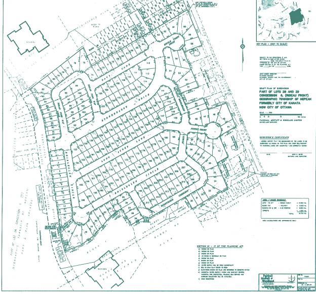
application proposes to subdivide the subject property in order to develop 217
lots for detached dwellings, to be located on eight new public streets. The subdivision provides for the
extension of Stonemeadow Drive from Spring Creek Crescent to Stonehaven Drive.
The new southerly arm of Stonemeadow Drive would form a four-way signalized
intersection with Bridle Park Drive, with this being the only access to
Stonehaven Drive. The proposal offers a variety of lot sizes, with 30 lots
having a frontage between 10.5 and 12 metres, 83 lots having a frontage of
13.4 metres and 104 lots having a frontage of 15.2 metres.
Proposed Zoning
It is proposed to rezone the subject property to Residential Type R1T Zone (R1T) in By‑law 2008-250 to permit development of detached residential dwellings on the site. This zone permits only fully detached dwellings, as well as a group home or diplomatic mission, subject to certain provisions. The zone provisions specify a lot area of 270 square metres, a minimum lot frontage of 10.5 metres, a maximum building height of 11 metres, and specific minimum yard setbacks.
It is proposed to rezone the subject property to Residential Type 1B Zone (R1B) in the former City of Kanata Zoning By-law 168-94. This zone permits a detached dwelling and group home, subject to certain provisions. The zone provisions specify a lot area of 270 square metres, a minimum lot frontage of 10.5 metres, a maximum building height of 10.5 metres, and specific minimum yard setbacks.
DISCUSSION
Official Plan
The Official Plan designates the property
General Urban Area. The General Urban
Area designation permits the development of a full range and choice of housing
types to meet the needs of all ages, incomes and life circumstances, in
combination with conveniently located employment, retail, service, cultural
leisure and institutional uses.
The Council-approved “translate the broad framework into detailed principles for development. These guidelines play an integral role in achieving high quality design throughout the City, and are A “greenfield neighbourhood” refers to a large area of land within the Urban Area that has not been developed previously, or that has the potential to be extensively redeveloped. It could be a single subdivision with fewer than 50 residential dwellings within an existing urban neighbourhood, or a larger area of new development. These design guidelines are focused on providing guidance for neighbourhood design during the subdivision review and zoning processes. Among the principles of the design guidelines are to mix various types of housing on each street while considering the relationship (height, size, bulk) between each other, and to existing houses; to locate residential buildings close to the property line, and to provide visual interest along the streetscape with a variety in setbacks and projections. The proposed plan of subdivision satisfies these criteria by offering a range of lot sizes and orienting buildings close to the street.
The subject site is surrounded by existing single-detached dwellings to the north, south and east, and by detached and townhouse dwellings across Stonehaven Drive. This application proposes to permit exclusively single-detached dwellings. The development to be permitted by the proposed zoning is therefore considered to be compatible with the existing development, in that they have the same qualities with respect to their building height, setbacks, form, massing, pattern, and character. Thus, the proposal is in conformity with the Official Plan.
Transportation
The Official Plan identifies Stonehaven Drive as a Major Collector road. This type of road is intended to serve as a connection between an arterial road (a major road which carries large volumes of traffic over long distances) and collector roads, which are the principal streets in urban neighbourhoods.
With the subdivision and zoning application, a Transportation Study was submitted in accordance with the Council’s approved Transportation Impact Assessment. The study addressed the introduction of the traffic from the proposed subdivision development into the overall transportation network of the existing community. The study also addressed additional traffic expectations from other lands on Stonehaven Drive for which the City has received a plan of subdivision application, which are located at 74 Stonehaven Drive.
The current applications that have been received represent the final phases of development within the Bridlewood Community. As a condition of subdivision approval, the proponent will be required to implement roadway modifications at the access point onto Stonehaven Drive. The City has received comments from the community on existing operational traffic concerns in Bridlewood that are unrelated to the proposed developments. Staff is investigating these concerns.
In general, Stonehaven Drive is experiencing increased traffic at peak times of the day. There are a number of reasons for this increase, one of which is a constraint at the intersection of Stonehaven and Richmond Road. There are high-level studies being completed in the surrounding area to analyze global traffic issues such as the Eagleson Road Environmental Assessment and the Terry Fox Drive/Hope Side Road extension Environmental Assessment. In addition, Traffic Operations staff has also been reviewing the existing internal community concerns and were consulted through the circulation process.
Servicing/Infrastructure
A serviceability study was submitted with the subdivision application that addresses the servicing needs for the lands. Development of these lands is being completed in accordance with master servicing requirements for the community and there are no servicing issues related to the development of these lands.
Conclusions
The proposed Zoning By-law amendment is to rezone the subject site to Residential Type 1T Zone (R1T) in By-law 2008-250 and Residential Type 1B (R1B) in the former City of Kanata By-law. This will allow development of a new residential subdivision compatible with the surrounding area. Large portions of the surrounding neighbourhood are zoned in an identical manner, so the lots created within the new plan of subdivision will be compatible in size with adjacent development, and the dwellings will be subject to the same provisions with respect to yard setbacks, coverage, and building height. The proposal makes use of existing services, and is supportive of transit and pedestrian use. The proposed zoning restricts the type of housing to single dwellings, addressing community concerns and facilitating compatibility. The proposed permitted uses are therefore considered appropriate for the site and respect the existing character of the community. Department staff support this Zoning By-law amendment because the proposed use is compatible with the surrounding area and conforms to the applicable policies outlined within the Official Plan.
ENVIRONMENTAL IMPLICATIONS
The property lies close to the Stoney Swamp Natural
Environment Area, which is located to the east of the partially unopened
Scissons Road allowance. The policies of the Official Plan require an
Environmental Impact Statement for all proposed development, including lot
creation, within 30 metres of the boundary of the NEA designation. The
Environmental Impact Statement was required to demonstrate that there would be
no negative impact on the natural features or their ecological functions as a
result of the proposed subdivision.
The Environmental Impact Statement confirmed that the Stoney Swamp Conservation Area would not be directly impacted by the construction of the residential units. The stormwater management system will not drain into the Conservation Area, since it will be conveyed through the stormwater system to the Monahan Drain Constructed Wetland. The influence of the site on the Conservation Area to the east is reduced due to Scissons Road and the existence of the residences on its west side. It was determined that potential impacts from the site would be negligible, relative to the overall urbanization of the area. Mitigation measures are specified as Draft Plan conditions for the Plan of Subdivision application. The Mississippi Valley Conservation Authority has no objections to the rezoning or the plan of subdivision.
CONSULTATION
Notice of this application was carried out in accordance with the City's Public Notification and Consultation Policy. Public comments and concerns were focussed on traffic issues in the Bridlewood community. The public comments and staff response are detailed in Document 3. The Ward Councillor is aware of this application and the staff recommendation.
FINANCIAL IMPLICATIONS
APPLICATION PROCESS TIMELINE STATUS
The application was not processed by the "On Time Decision Date" established for the processing of Zoning By-law amendments for several reasons: the application was On Hold for an extended period of time while the applicant conducted additional traffic impact studies. Additional time was required for issue resolution, as well as additional community consultation initiated by the applicant to address residents’ concerns regarding traffic.
SUPPORTING DOCUMENTATION
Document 1 Location
Map – (Revised)
Document 2 Details of Recommended zoning
Document 3 Consultation Details
Document 4 Draft Plan of Subdivision
DISPOSITION
City Clerk’s Branch, Council and Committee Services to notify the owner, (Urbandale Corporation, 2193 Arch Street, Ottawa, Ontario K1G 2H5, Attention: Ms Mary Jarvis), OttawaScene.com, 174 Colonnade Road, Ottawa, ON, K2E 7J5, Ghislain Lamarche, Program Manager, Assessment, Financial Services Branch (Mail Code: 26-76) of City Council’s decision.
Planning, Transit and the Environment Department to prepare the implementing by-law, forward to Legal Services Branch and undertake the statutory notification.
Legal Services Branch to forward the implementing by-law to City Council
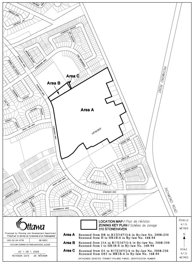
LOCATION MAP REVISED
DOCUMENT 1
DETAILS OF RECOMMENDED ZONING REVISED
DOCUMENT 2
Proposed changes to By-law
2008-250
That
the Zoning Map of By-law 2008-250 be amended such that the lands at 310
Stonehaven Drive, identified on the zoning key map in Document 1, be changed as
follows:
Area A: DR Zone to R1T Zone
Area B: I1A Zone to R1T Zone
Area C: O1 Zone to R1T Zone
1. The lands shown as Area A on
Document 1 zoned DR, Area B on Document 1 zoned I1A and Area C on Document 1
zoned O1 under By-law 2008-250 will be rezoned to R1T [xxxx]-h.
2. Section 239 of By-law 2008-250 is
amended to add a new exception including the following provisions:
On lands zoned R1T [xxxx] with a holding symbol, the ‘h’ symbol denotes that the units may be constructed only after the removal of the ‘h’ symbol, which removal may only occur when the transportation solution is found and implemented to the City’s satisfaction, that improves the intersection of Stonehaven Drive and Richmond Road, and Stonehaven Drive/Richmond Road Corridor.
Proposed changes to By-law No.
168-94 for the former City of Kanata
That the Zoning Schedules of
By-law 168-94 as amended, be further amended such that the lands at 310
Stonehaven Drive, identified on the zoning key map in Document 1, be changed as
follows:
Area A: H Zone to R1B Zone
Area B: I1A Zone to R1B Zone
Area C: OS1 Zone to R1B Zone
1. The lands shown as Area A on
Document 1 zoned H, Area B on Document 1 zoned I1A and Area C on Document 1
zoned OS1 will be rezoned to HR1B-6.
2. Subsection 6(3) is amended to add a
new special zone including the following provisions:
On lands
zoned R1T [xxxx] with a holding symbol, the ‘h’ symbol denotes that the units
may be constructed only after the removal of the ‘h’ symbol, which removal may
only occur when the transportation solution is found and implemented to the
City’s satisfaction, that improves the intersection of Stonehaven Drive and
Richmond Road, and Stonehaven Drive/Richmond Road corridor.
CONSULTATION DETAILS DOCUMENT
3
NOTIFICATION AND CONSULTATION PROCESS
Notification and public consultation was undertaken in accordance with the Public Notification and Public Consultation Policy approved by City Council for Zoning By-law Amendments. Two information signs were posted on the property, and notice of the application was circulated to the Bridlewood Community Association. The ward Councillor is aware of the application and the staff recommendation.
A public meeting was held in the community on May 15, 2007, in fulfillment of the requirements for the associated subdivision application. A summary of the public comments and staff responses is listed below.
Traffic
Comments: The primary concern of residents is the impact of the additional homes on the current traffic congestion on Stonehaven Drive. A sample of comments is as follows:
·
A
four-lane Richmond Road should have been constructed through NCC lands before
allowing the scale of Bridlewood density to continue with Stonehaven
being the only easterly exit route. It is the city's responsibility to
remedy the situation.
· Stonehaven Drive is currently failing to process morning rush-hour traffic on a timely or safe basis. Additional housing will only increase traffic.
· The school bus traffic combined with the presence of four schools on Stonehaven Drive poses serious congestion problems during the morning rush hours as well as a safety concern.
· There is a need for another “feeder street” from Bridlewood to Richmond Road. Until an alternative route other that Stonehaven Drive is established, there should be a moratorium on future growth in Bridlewood.
· Richmond Road must be widened to two lanes northbound for a greater distance, to allow traffic to merge safely and smoothly at the Stonehaven/Richmond Road intersection.
· Residential development should be limited until there is the infrastructure in place to support the additional traffic.
Response: The Official Plan identifies Stonehaven Drive as a Major Collector road. This type of road is intended to serve as a connection between an arterial road (a major road which carries large volumes of traffic over long distances) and collector roads, which are the principal streets in urban neighbourhoods.
With the subdivision and zoning application, a Transportation Study was submitted in accordance with the Council’s approved Transportation Impact Assessment. The study addressed the introduction of the traffic from the proposed subdivision development into the overall transportation network of the existing community. The current applications that we have received represent the final phases of development within the Bridlewood Community for Urbandale Corporation’s lands. The proposed development will be required to implement roadway modifications at the accesses onto Stonehaven Drive. The City has received comments from the community on existing operational traffic concerns in Bridlewood that are unrelated to the proposed developments. Staff is investigating these concerns.
In general, due to growth within the community, Stonehaven Drive is experiencing increased traffic at peak times of the day. There are a number of reasons for this increase one of which is a restriction that is caused at the intersection of Stonehaven and Richmond Road. There are high-level studies being completed in the surrounding area to analyze global traffic issues such as the Eagleson Road Environmental Assessment and the Terry Fox Drive/Hope Side Road extension Environmental Assessment. In addition, Traffic Operations staff has also been reviewing the existing internal community concerns and were consulted through the circulation process.
PROPOSED
DRAFT PLAN OF SUBDIVISION DOCUMENT 4