|
5. ZONING - PART OF 3538 JOCKVALE ROAD ZONAGE – PARTIE DU 3538, CHEMIN
JOCKVALE |
Committee
recommendations
(This
application is subject to Bill 51)
That Council:
1. Approve an amendment
to the City of Ottawa Zoning By-law 2008-250 to change the zoning of Part of
3538 Jockvale Road from DR - Development Reserve Zone to O1 - Parks and Open
Space Zone, R1Z [664] - Residential First Density Sub Zone Z Exception 664, R3Z
[XX] - Residential Third Density Sub Zone Z Exception XX, R3Z [XY] -
Residential Third Density Sub Zone Z Exception XY, and R4Z [XZ] – Residential
Fourth Density Sub Zone Z Exception XZ, as detailed in Document 2 and as shown
in Document 1.
2. Approve an amendment
to the former City of Nepean Urban Area Zoning By-law to change the zoning of
Part of 3538 Jockvale Road from FG - Future Growth Zone to PRP - Parks &
Recreation Zone (Public), RMU Blk 4 - Residential Mixed Unit Zone Block 4, R5B
Blk XX - Residential Fifth "B" Density Zone Block XX, R5B Blk XY -
Residential Fifth "B" Density Zone Block XY, and R6A Blk XZ -
Residential Sixth "A" Density Zone Block XZ, as detailed in Document
2 and as shown in Document 1.
RecommandationS du Comité
(Cette
demande est assujettie au Règlement 51)
Que le
Conseil :
1.
approuve une modification au Règlement
de zonage 2008-250 de la Ville d’Ottawa afin de changer le zonage d’une partie
du 3538, chemin Jockvale de DR – Zone d’aménagement futur à O1 – Zone d’espaces
verts et de loisirs, à R1Z [664] – Zone résidentielle de première densité,
sous-zone Z, assortie de l’exception 664, à R3Z [XX] – Zone résidentielle de
troisième densité, sous-zone Z, assortie de l’exception XX, à R3Z [XY] – Zone
résidentielle de troisième densité, sous-zone Z, assortie de l’exception XY, et
à R4Z [XZ] – Zone résidentielle de quatrième densité, sous-zone Z, assortie de
l’exception XZ, comme l’explique le document 2 et le montre le document 1.
2.
approuve
une modification au règlement de zonage du secteur urbain de
l’ancienne Ville de Nepean afin de changer le zonage d’une partie du 3538,
chemin Jockvale de FG – Zone de croissance future à PRP – Zone de parcs et
loisirs (publique), à RMU Blk 4 – Zone à utilisation résidentielle mixte bloc
4, à R5B Blk XX – Zone résidentielle de cinquième densité B, bloc XX, à R5B Blk
XY – Zone résidentielle de cinquième densité B, bloc XY et à R6A Blk XZ – Zone
résidentielle de sixième densité A, bloc XZ, comme l’explique le document 2 et
le montre le document 1.
Documentation
1. Deputy City Manager, Planning, Transit and the Environment report dated
8 September 2008 (ACS2008-PTE-PLA-0158).
2. Extract of Draft Minutes, 23 September
2008.
Report to/Rapport au :
Planning and Environment Committee
Comité de l'urbanisme et de l'environnement
and Council / et au Conseil
8 September 2008 / le 8 septembre 2008
Submitted by/Soumis par : Nancy Schepers, Deputy City Manager
Directrice municipale adjointe
Planning, Transit and the Environment
Urbanisme, Transport en commun et Environnement
Contact Person/Personne ressource : Danny Page,
Acting Manager/Gestionnaire intérimaire, Development Approvals/Approbation des
demandes d'aménagement, / Planning Branch/Direction de l’urbanisme
(613) 580-2424, 27595 Danny.Page@ottawa.ca
|
SUBJECT: |
ZONING - Part of 3538 Jockvale Road
(FILE NO. D07-02-08-0061) |
|
|
|
|
OBJET : |
REPORT RECOMMENDATIONS
1.
Approve an amendment to the City of Ottawa Zoning
By-law 2008-250 to change the zoning of Part of 3538 Jockvale Road from DR -
Development Reserve Zone to O1 - Parks and Open Space Zone, R1Z [664] -
Residential First Density Sub Zone Z Exception 664, R3Z [XX] - Residential
Third Density Sub Zone Z Exception XX, R3Z [XY] - Residential Third Density Sub
Zone Z Exception XY, and R4Z [XZ] –
Residential Fourth Density Sub Zone Z Exception XZ, as detailed in Document 2 and as shown in Document
1.
2.
Approve
an amendment to the former City of Nepean Urban Area Zoning By-law to change
the zoning of Part of 3538 Jockvale Road from FG - Future Growth Zone to PRP -
Parks & Recreation Zone (Public), RMU Blk 4 - Residential Mixed Unit Zone
Block 4, R5B Blk XX - Residential Fifth "B" Density Zone Block XX,
R5B Blk XY - Residential Fifth "B" Density Zone Block XY, and R6A Blk
XZ - Residential Sixth "A" Density Zone Block XZ, as detailed in
Document 2 and as shown in Document 1.
RECOMMANDATIONS DU RAPPORT
Que le Comité de recommande au Conseil :
1. d’approuver une modification au Règlement de zonage 2008-250 de la Ville
d’Ottawa afin de changer le zonage d’une partie du 3538, chemin Jockvale de DR
– Zone d’aménagement futur à O1 – Zone d’espaces verts et de loisirs, à R1Z
[664] – Zone résidentielle de première densité, sous-zone Z, assortie de
l’exception 664, à R3Z [XX] – Zone résidentielle de troisième densité,
sous-zone Z, assortie de l’exception XX, à R3Z [XY] – Zone résidentielle de
troisième densité, sous-zone Z, assortie de l’exception XY, et à R4Z [XZ] –
Zone résidentielle de quatrième densité, sous-zone Z, assortie de l’exception
XZ, comme l’explique le document 2 et le montre le document 1.
2. d’approuver
une modification au règlement de zonage du secteur urbain de
l’ancienne Ville de Nepean afin de changer le zonage d’une partie du 3538,
chemin Jockvale de FG – Zone de croissance future à PRP – Zone de parcs et
loisirs (publique), à RMU Blk 4 – Zone à utilisation résidentielle mixte bloc
4, à R5B Blk XX – Zone résidentielle de cinquième densité B, bloc XX, à R5B Blk
XY – Zone résidentielle de cinquième densité B, bloc XY et à R6A Blk XZ – Zone
résidentielle de sixième densité A, bloc XZ, comme l’explique le document 2 et
le montre le document 1.
BACKGROUND
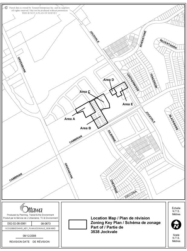
The subject lands are located to the south of Jock River, flanked by Jockvale Road to the east and Cambrian Road to the south. The 3.43-hectare vacant lands are part of Stonebridge Phase 10 North subdivision that is comprised of a mix of lots for single detached, multiple attached and blocks for stacked townhouses. The subdivision was draft approved on July 11, 2008. Existing and planned residential developments surround the site.
Purpose of
Zoning Amendment
The proposal is to rezone the land to accommodate
residential development consisting of 20 single detached houses, 30 street
townhouses, 26 stacked townhouses and a public park.
The subject site is currently designated Development Reserve Zone (DR) under the Comprehensive Zoning By-law and Future Growth Zone (FG) under the former City of Nepean Urban Area Zoning By-law. The purpose of the two zones is to recognize lands intended for future urban development while allowing limited interim uses including agricultural, conservation, and rural residential.
Under the Comprehensive Zoning By-law, the proposed zones are Parks and Open Space Zone (O1) to allow a public park, Residential First Density Sub Zone Z (R1Z) to allow 20 single detached houses, Residential Third Density Sub Zone Z (R3Z) to allow 30 street townhouses, and Residential Fourth Density Sub Zone Z (R4Z) to allow 26 stacked townhouses.
Under the former City of Nepean Urban Area Zoning By-law, the proposed zones are Parks and Recreation Public Zone (PRP), Residential Mixed Unit Zone (RMU), Residential Fifth “B” Density Zone (R5B), and Residential Sixth “A” Density Zone (R6A), respectively.
Revisions to the Original Application
In the original application as submitted on May 14, 2008, the proposal included a public park, 20 single detached houses, 31 street townhouses, 12 stacked townhouses and 16 walk-up units. On August 8, 2008, the applicant decided to revise the proposal to exclude all walk-up units, remove one street townhouse and add 14 stacked townhouses. This modification does not change the application in nature because the proposed zones remain the same. Additionally, as requested by staff, the boundary of Area E was adjusted to include the required parking.
DISCUSSION
The Official Plan designates the property
General Urban Area. This designation
permits the development of a full range and choice of housing types to meet the
needs of all ages, incomes and life circumstances, in combination with
conveniently located employment, retail, service, cultural leisure and
institutional uses.
The Council approved Barrhaven South Community Design Plan (CDP) is a statutory document that complements Official Plan policies and provides more detailed guidance regarding the form and character of Barrhaven South. The site is located on the eastern edge of the CDP Sub‑Planning Area 1. Under the CDP the subject lands are predominantly designated Medium Density Residential. It permits all forms of ground-oriented multiple dwellings, including street and stacked townhouses.
Details of Proposed Zoning
Comprehensive
Zoning By-law
The proposed zoning for Area A (as shown on Document 1) is Parks and Open Space Zone (O1). The proposed zoning for Area B is Residential Third Density Sub Zone Z (R3Z) that permits only detached dwellings. A provision is made to specify the maximum accessory building height. The proposed zoning for Area C and Area D is Residential Third Density Sub Zone Z (R3Z). This zone permits detached, semi-detached and multiple attached dwellings. The site-specific zone provisions would specify a maximum projection of 2.7 metres from a garage front wall to a main wall or covered porch. An additional provision would be made to the R3Z zone for Area D to allow interim parking and access serving Area E until such time as Area D is to be developed. The proposed zoning for Area E is Residential Fourth Density Sub Zone Z (R4Z) with exceptions. This zone permits single detached, semi-detached and multiple-attached dwellings, as well as stacked townhouses and planned unit developments. The site-specific zone provisions would specify a maximum building height of 13 metres, minimum yard setbacks and provisions for permitted encroachments. An additional provision would be made to the R4Z zone to allow interim parking and access to be located on Area D.
Former City of Nepean Urban Area Zoning By-law
The proposed zoning for Area A is Parks and Recreation (Public) Zone (PRP). The proposed zoning for Area B is Residential Mixed Unit Zone (RMU) Block 4 that permits only detached dwellings. A provision is made to specify the maximum accessory building height. The proposed zoning for Area C and D is Residential Fifth “B” Density Zone (R5B). This zone permits multiple attached dwellings and converted rooming houses. The site-specific provisions would specify the maximum lot coverage, building height, minimum interior yard, and provisions for permitted obstructions. An additional provision would be made to the R5B zone for Area D to allow interim parking and access serving Area E until such time as Area D is to be developed. The proposed zoning for Area E is Residential Sixth “A” Density Zone (R6A). This zone permits apartments and converted rooming houses. The site-specific provisions would specify a maximum building height of 13 metres, the maximum lot coverage, minimum yard setbacks and provisions for permitted obstructions. An additional provision would be made to the R6A zone to allow interim parking and access to be located on Area D.
Analysis
The proposed development consists of various dwelling types from singles and street townhouses to stacked townhouses. It is consistent with the policies as outlined in the Official Plan and Barrhaven South CDP in that the new neighbourhood will provide a range of housing options and opportunities.
The site is adjacent to two arterial roads. The location and proposed land use complies with the CDP Policy 5.1.2 that Medium Density Residential shall be focused along arterial and collector roads, major intersections, and neighbourhood focal points.
The overall residential density of the area is 38 net units per hectare, which meets the density target of 37.3 net units per hectare for the Sub-Planning Area 1 as set out in the CDP. This is in agreement with the CDP Policy 5.1.2 that single detached houses can be permitted in the Medium Density Residential area provided the target densities in the sub-planning areas are achieved.
The subject lands are located in the Stonebridge Subdivision Phase 10 North and surrounded by residential uses. To the east and south, lands are zoned R1A – First Density Residential and R3Z – Third Density Residential; to the west and north, lands are zoned DR – Development Reserve. The proposed R1Z and R3Z zones are in harmony with the existing zones.
The proposed R6A zone, which is new to the area, is to allow stacked townhouses and will permit a maximum building height of 13 meters. Comparing to the surrounding zones that permit a maximum building height of 11 metres, the increase in height is minimal and the impact is insignificant. The proposed stacked townhouses will have similar qualities with respect to their setbacks, massing and character as nearby street townhouse units.
Conclusion
The proposed land use conforms to the applicable policies as outlined within the Official Plan and Community Design Plan. The proposed provisions are generally minor in nature; the provisions to the setbacks and encroachments help promote an enhanced street presence; and the provisions to the building height help improve the compatibility of the proposed development. The Department supports this application.
CONSULTATION
Notice of this application was carried out in accordance with the City's Public Notification and Consultation Policy. The Ward Councillor is aware of this application and the staff recommendation. Details of the consultation are shown in Document 3.
FINANCIAL IMPLICATIONS
APPLICATION PROCESS TIMELINE STATUS
The application was not processed by the "On Time Decision Date" established for the processing of Zoning By-law amendments due to the applicant's need to modify the original application.
SUPPORTING DOCUMENTATION
Document 1 Location Map
Document 2 Details of Recommended Zoning
Document 3 Consultation Details
DISPOSITION
City Clerk’s Branch, Council and Committee Services to notify the owner/applicant, Rob Pierce, Monarch Homes, 3584 Jockvale Road, Nepean ON K2C 3H2, OttawaScene.com, 174 Colonnade Road, Unit #33, Ottawa, ON K2E 7J5, Ghislain Lamarche, Program Manager, Assessment, Financial Services Branch (Mail Code: 26-76) of City Council’s decision.
Planning, Transit and the Environment Department to prepare the implementing by-law, forward to Legal Services Branch and undertake the statutory notification.
Legal Services Branch to forward the implementing by-law to City Council.
LOCATION MAP DOCUMENT 1
DETAILS OF RECOMMENDED ZONING DOCUMENT 2
Proposed Changes to the Comprehensive Zoning By-law
1.
That the lands known municipally as part
of 3538 Jockvale Road,
shown as Areas A to E in Document 1, be rezoned as follows:
Area A from DR to O1
Area B from DR to R1Z [664]
Area C from DR to R3Z [XX]
Area D from DR to R3Z [XY]
Area E from DR to R4Z [XZ]
2.
(Area
C, R3Z [XX])
Despite Table 160B
Endnote 8, on lands zoned R3Z [XX] the following provision shall apply:
- The minimum setback between the vehicular entrance to a private garage or carport and an existing or planned sidewalk is 6.2 m. The maximum distance the front wall of a private garage may extend beyond the building front wall, sidewall, covered porch or veranda is 2.7 metres.
3.
(Area D, R3Z [XY])
Despite Table 160B Endnote 8, on lands zoned R3Z [XY] the following provision shall apply:
-
The minimum setback between the vehicular entrance to a
private garage or carport and an existing or planned sidewalk is 6.2 m. The maximum distance the front wall of a
private garage may extend beyond the building front wall, sidewall, covered
porch or veranda is 2.7 metres.
Despite Section 159, on lands
zoned R3Z [XY] the following provision shall apply:
- Required parking and access for lands zoned R4Z [XZ] can be located on lands zoned R3Z [XY] until such time as the lands zoned R3Z [XY] are to be developed.
4. (Area E, R4Z [XZ]
Despite Section 100 (1) (c), on lands zoned R4Z [XZ], the following provision shall apply:
- Required parking and access is permitted through lands zoned R3Z [XY] until such time as the lands zoned R3Z [XY] are to be developed.
Despite Section 65, on lands zoned R4Z [XZ], the following provisions shall apply:
- Maximum permitted height above finished grade of steps projecting into any required yard is 1.8 m.
- Maximum distance between the permitted projection and a lot line is 1.0 m.
Despite Section 162 and Table 162A, on lands zoned R4Z [XZ], the following provisions shall apply:
- Minimum rear yard is 6 m
-
Maximum building height is 13 m
Despite Table 162A Endnote 1 (b), on lands zoned R4Z [XZ] the following provisions shall apply:
- In the case of building walls less than or equal to 11 m in height, the yard setback is 1.5 m for the first 21 m back from a street lot line. In the case of building walls greater than 11 m in height, the yard setback is 3 m for the first 21 m back from a street lot line.
Proposed
Changes to the Former City of Nepean Urban Area Zoning By-law
1.
That
the lands known municipally as part of 3538 Jockvale Road, shown as Areas A to E in Document
1, be rezoned as follows:
Area A from FG to PRP
Area B from FG to RMU Block 4
Area C from FG to R5B Block XX
Area D from FG to R5B Block XY
Area E from FG to R6A Block XZ
2. (Area C, R5B Block XX)
Notwithstanding Subsection 6:5B:2, on lands zoned R5B Block XX the following provisions shall apply:
- LOT COVERAGE (Maximum) 55%
- BUILDING HEIGHT (Maximum) 11.0 m
- YARD SIDE (Minimum)
Abutting a street 6.0 m
Not abutting a street 1.5 m
Notwithstanding Subsection 5:9, lands zoned R5B Block XX shall be considered as one lot for zoning purposes pursuant to the Planning Act, as amended, the Condominium Act, as amended, or any similar legislation. This provision will not apply if the severed LOTS comply with subsection 6:5B:2 or if minor variances are granted respecting the provisions of subsection 5:9 pertaining to LOTS and any other applicable requirements.
Notwithstanding Subsection 5:18, on lands zoned R5B Block XX, maximum permitted obstruction into the front or rear yard is 0.6 metres
3. (Area D, R5B Block XY)
Notwithstanding Subsection 6:5B:2, on lands zoned R5B Block XY, the following provisions shall apply:
- LOT COVERAGE (Maximum) 55%
- BUILDING HEIGHT (Maximum) 11.0 m
- YARD SIDE (Minimum)
Abutting a street 6.0 m
Not abutting a street 1.5 m
Notwithstanding Subsection 5:9, lands zoned R5B Block XY shall be considered as one lot for zoning purposes pursuant to the Planning Act, as amended, the Condominium Act, as amended, or any similar legislation. This provision will not apply if the severed LOTS comply with subsection 6:5B:2 or if minor variances are granted respecting the provisions of subsection 5:9 pertaining to LOTS and any other applicable requirements.
Notwithstanding Subsection 5:18, on lands zoned R5B Block XY, maximum permitted obstruction into the front or rear yard is 0.6 metres.
Notwithstanding Subsection 5:20:1, required parking and access for lands zoned R6A Block XZ can be located on lands zoned R5B Block XY until such time as the lands zoned R5B Block XY are to be developed.
4. (Area E, R6A Block XZ)
Notwithstanding Subsection 6:6A:2, on lands zoned R6A Block XZ, the following provisions shall apply:
- LOT COVERAGE (Maximum) 35%
- LOT AREA (Minimum) 3,000 sq m
- BUILDING HEIGHT (Maximum) 13 m
- YARD FRONT (Minimum) 5.5 m
- YARD REAR (Minimum) 6 m
- YARD SIDE (Minimum) 1.5 m
- BUILDING MAIN, spacing (Minimum) 0 m
Notwithstanding Subsection 5:9, lands zoned R6A Block XZ shall be considered as one lot for zoning purposes despite the lawful severance of a lot pursuant to the Planning Act, as amended, or any similar legislation.
Notwithstanding Section 5:18, on lands zoned R6A Block XZ, maximum permitted height above finished grade of steps projecting into any required yard is 1.8 metres, but not closer than 1 meter to a lot line.
Notwithstanding Subsection 5:20:1, for lands zoned R6A Block XZ, required parking and access is permitted through lands zoned R5B Block XY until such time as the lands zoned R5B Block XY are to be developed.
CONSULTATION DETAILS DOCUMENT
3
NOTIFICATION AND CONSULTATION PROCESS
Notification and public consultation was undertaken in accordance with the Public Notification and Public Consultation Policy approved by City Council for Zoning By-law amendments.
PUBLIC COMMENTS
The following comments were received as a result of the public notification:
The proposed urban flats do not blend in with surrounding
area (mainly singles).
Response
to Public Comments
The applicant has decided to eliminate all walk-up flat units and replace them with stacked townhouses. The modified application now includes 20 singles, 30 street townhouses and 26 stacked townhouses.
Summery of COMMUNITY ORGANIZATION COMMENTS
Stonebridge Community Association
1)
The proposed 4/3 storey buildings are not reasonably
located – from the City sponsored forums on intensification we were advised
that outside the greenbelt intensification will happen primarily along the
proposed rapid transit corridor with particular focus near actual BRT stations.
2)
The proposed 4/3 storey buildings will have “towering”
effect to our community.
3)
The proposal is going to "densify" automobile
numbers. We are already anticipating
serious traffic issues at Jockvale/Cambrian due to the high concentration
of housing in this area (current & future) and long before
either is 4-laned as planned.
4)
The proposed 4/3 storey dwellings are the only stacked
units in the entire community east of existing Greenbank Road. These units are out of place and
incompatible with the surrounding.
5)
We would also be interested in knowing how many
clusters will be built for these proposed 26 stacked and confirmation
on parking plan.
Response to Community organization Comments
1) The location of the proposed development is consistent with the Official Plan and CDP land use designation and policies.
2) The height of the proposed stacked townhouses has been adjusted from originally proposed 15 metres to about 12.6 metres. Comparing to the neighbouring zones that permit a maximum building height of 11 metres, the increase is acceptable. The distance between the stacked townhouses and existing single detached homes is about 70 metres; extensive landscaping will be provided along Jockvale Road.
3) A Traffic Impact Study (TIS) for Stonebridge Subdivision Phase 10 to 12 concludes that the intersection of Jockvale Road and Cambrian Road will operate at acceptable levels of service during the weekday morning and afternoon peak hours of traffic at the 2018 study horizon year.
4) Over time, medium-density developments (i.e. stacked townhouses) can be expected in appropriate areas in the Stonebridge development. High-density development (i.e. apartments) can be expected in areas such as community core and within close proximity to transit stations.
5) Two “clusters” of stacked townhouses are proposed in this application. 39 parking spaces are required under the former City of Nepean Zoning By-law. Design of the parking area, as well as architecture details will be further reviewed during the site plan control, which is also subject to public notification.