|
1. OFFICIAL PLAN
AMENDMENT AND ZONING BY-LAW AMENDMENT - RICHMOND ROAD/WESTBORO COMMUNITY
DESIGN PLAN – REVISION
modification au plan officiel et modification au
règlement de zonage - plan de conception communautaire du chemin
richmond/westboro - RéVISION
|
Committee recommendations as
amended
(This
matter is subject to Bill 51)
That Council:
1.
Approve an amendment to the
Official Plan for the City of Ottawa, Volume 2A, to incorporate the Richmond
Road/Westboro Community Design Plan as a Secondary Plan as detailed in Document
2 (distributed separately and on file with the City Clerk), as amended by
deleting the second bullet point in Part B – The Amendment, Section 1.3.4 b)
and replacing it with the following:
“Recognize that
for property at 747 Richmond Road, the Ontario Municipal Board has approved
heights of eight to twelve storeys on the basis of measurements specifically
outline in the Ontario Municipal Board’s decision and reflected in the approved
zoning by-law.”
2.
Approve an amendment to Zoning By-law
2008-250 of the City of Ottawa as shown on the location maps and detailed in
Document 3.
3.
Approve an amendment to the former City of Ottawa Zoning By-law,
93-98 for 319, part of 320, 344 and 351 McRae Avenue as shown on the
location maps and detailed in Document 3.
4.
Approve an amendment to the Richmond Road/Westboro Community Design
Plan as detailed in Document 4, as amended by replacing item 4 to read as
follows:
Sector 6.3 Sector 2 –
Woodroffe North, end of last paragraph, be amended by adding:
“However, on September
16, 2008, the Ontario Municipal Board approved heights of eight to twelve
storeys on the basis of measurements specifically outlined in the Board’s
decision and reflected in the approved zoning by-law.”
Recommandations modifiÉes du Comité
(Cette question est assujettie au Règlement 51)
Que le Conseil :
1.
approuve une modification au Plan
officiel de la Ville d’Ottawa, Volume 2A, afin d’intégrer le Plan de conception
communautaire du chemin Richmond/Wesboro en tant que Plan secondaire, tel qu’il
est expliqué dans le Document 2 (distribué séparément et déposé auprès du
greffier de la Ville) et modifié par la suppression du second point de la
partie B – La modification, alinéa 1.3.4 b), et son remplacement par le texte
qui suit :
« Reconnaître que, pour ce qui concerne la propriété située au 747,
chemin Richmond, la Commission des affaires municipales de l’Ontario a approuvé
des hauteurs de huit à douze étages en fonction de mesures indiquées
expressément dans la décision de la Commission et se reflétant dans le
règlement de zonage approuvé. »
2.
approuve une modification au
Règlement de zonage 2008-250 de la Ville d’Ottawa, tel qu’il est indiqué sur
les plans de situation et expliqué en détail dans le Document 3.
3.
approuve une modification au
Règlement de zonage 93-98 de l’ancienne Ville d’Ottawa, tel qu’il indiqué sur
les plans de situation et expliqué en détail dans le Document 3.
4. approuve
une modification au Plan de conception communautaire du chemin
Richmond/Westboro, tel qu’il est expliqué en détail dans le Document 4,
modifié par le remplacement du point 4 par ce qui suit :
Secteur
6.3 Secteur 2 – Woodroffe Nord, fin du dernier paragraphe, modifié par l’ajout
du passage suivant :
« Toutefois, le 16 septembre 2008, la Commission des affaires
municipales de l’Ontario a approuvé des hauteurs de huit à douze étages en
fonction des mesures indiquées expressément dans la décision de la Commission
et se reflétant dans le règlement de zonage approuvé. »
Documentation
1.
Deputy
City Manager's report, Infrastructure Services and Community Sustainability,
dated 31 October 2008 (ACS2008-ICS-PLA-0228).
2.
Extract
of Minutes 39, 23 September 2008.
3. Extract of Draft Minutes 43, 14
November 2008.
Report to/Rapport au :
Planning and Environment Committee
Comité de l'urbanisme et de l'environnement
and Council / et au Conseil
31 October 2008 / 31 octobre 2008
Submitted
by/Soumis par : Nancy
Schepers, Deputy City Manager
Directrice municipale adjointe,
Infrastructure Services and Community Sustainability
Services d’infrastructure et
Viabilité des collectivités
Contact Person/Personne-ressource :
Richard Kilstrom, Manager/Gestionnaire, Community Planning and
Design/Aménagement et conception communautaire, Planning Branch/Direction de
l’urbanisme
(613)
580-2424 x22653, Richard.Kilstrom@ottawa.ca
|
|
Ref N°: ACS2008-ICS-PLA-0228
|
SUBJECT:
|
OFFICIAL PLAN
AMENDMENT AND ZONING BY-LAW AMENDMENT - RICHMOND ROAD/WESTBORO COMMUNITY
DESIGN PLAN - REVISION
|
|
|
|
OBJET :
|
modification au plan officiel et modification au règlement de zonage –
plan de conception communautaire du chemin richmond/westboro - RéVISION
|
REPORT
RECOMMENDATION
That Planning and Environment Committee recommend
Council:
1. Approve an amendment
to the Official Plan for the City of Ottawa, Volume 2A, to incorporate the
Richmond Road/Westboro Community Design Plan as a Secondary Plan as detailed in
Document 2 (distributed separately and on file with the City Clerk).
2. Approve an amendment
to Zoning By-law 2008-250 of the City of Ottawa as shown on the location maps
and detailed in Document 3.
3. Approve an amendment to the former City of Ottawa Zoning
By-law, 93-98 for 319, part of 320, 344 and 351 McRae Avenue as shown on the
location maps and detailed in Document 3.
4. Approve an amendment to the Richmond Road/Westboro Community
Design Plan as detailed in Document 4.
RECOMMANDATION DU RAPPORT
Que le Comité de
l’urbanisme et de l’environnement recommande au Conseil :
1. d’approuver
une modification au Plan officiel de la Ville d’Ottawa, Volume 2A, afin
d’intégrer le Plan de conception communautaire du chemin Richmond/Wesboro en
tant que Plan secondaire, tel qu’il est expliqué dans le Document 2 (distribué
séparément et déposé auprès du greffier de la Ville).
2. d’approuver
une modification au Règlement de zonage 2008-250 de la Ville d’Ottawa, tel
qu’il est indiqué sur les plans de situation et expliqué en détail dans le
Document 3.
3. d’approuver
une modification au Règlement de zonage 93-98 de l’ancienne Ville d’Ottawa, tel
qu’il indiqué sur les plans de situation et expliqué en détail dans le Document
3.
4.
d’approuver une modification au Plan
de conception communautaire du chemin Richmond/Westboro, tel qu’il est expliqué
en détail dans le Document 4.
BACKGROUND
On July 9, 2007,
City Council approved the Richmond Road/Westboro Community Design Plan (CDP),
and also approved that the CDP be conferred secondary plan status via an
Official Plan Amendment (OPA). In keeping
with Council’s direction, this report recommends the approval of an amendment
to the Official Plan, Volume 2A to incorporate the CDP as a Secondary
Plan. Also on July 9, 2007 Council
deferred a decision on the accompanying Zoning By-law amendment and thus that
amendment needs to be brought forward for consideration by Council in this
report in order to implement the recommendations of the CDP.
On September 23,
2008 Planning and Environment Committee referred this report back to staff for
further clarification and directed that it rise to the meeting of November 14,
2008. Revisions have now been made to
Document 2, the Official Plan Amendment, which, when adopted, will become the
Richmond Road/Westboro Secondary Plan.
These revisions replace the term “building profile” with
“general maximum building height ranges,” the result of which is that
more specific maximum building heights are set out for the various sub-areas of
the Plan, thus better reflecting the recommendations of the CDP.
A January 25, 2006
Council motion deferred all rezoning and Official Plan Amendment requests for
the Richmond Road/Westboro CDP study area until the completion and approval of
the CDP process. As this report completes the process with the OPA and zoning
recommendations, this motion can now be rescinded.
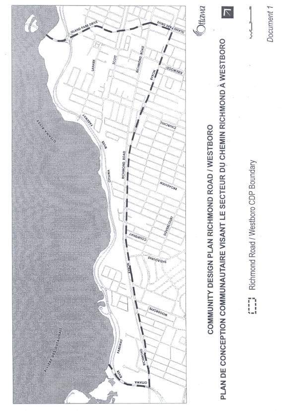
The OPA
boundaries as shown on the Location Map (Document 1), include Island Park Drive
on the east, the Ottawa River on the north, Ottawa River Parkway on the west
and Byron Avenue on the south, an area of 2.7 square kilometres. Two Traditional Mainstreets, Richmond Road,
running east-west along its entire length, and Scott Street, are included in
the planning area. The OPA encompasses part of, or is bounded by, several
neighbourhoods that are influenced by their proximity to Richmond Road,
including Westboro, Westboro Beach, Hampton-Iona, Highland Park, McKellar Park,
Woodroffe North and Woodpark.
DISCUSSION
RECOMMENDATION 1
Recommendation 1 is to approve an
amendment to the Official Plan to add the Richmond/Westboro CDP as a Secondary
Plan to Volume 2A as detailed in Document 2.
As per the report on Community Design Plans, approved by Council on
January 23, 2008, the Secondary Plan will include those parts of the CDP that
establish the vision, objectives and principles on which the CDP is based, that
address land use, and that describe the components that support land use,
including transportation studies, general maximum building height ranges, and a
greenspace strategy.
Also, as per
Council's January 23, 2008 direction, the OPA has been divided into three
primary parts: Part A - The Preamble
provides all the background information, including the history of the
neighbourhood, existing conditions and issue analysis, the existing planning
context, demographics, community issues and the consultation process; Part B -
The Amendment provides the land use strategy and those components noted above;
and, Part C - The Appendix contains the implementation strategy addressing such
matters as streetscaping improvements, urban design guidelines, a 3D model, and
zoning directions. Note that Part B is
written in the policy summary format of Secondary Plans that now exists in the
Official Plan, including references to and mapping of general maximum building
height ranges.
Whilst the
Richmond Road/Westboro Secondary Plan will become part of the Official Plan,
the CDP will continue to be a stand-alone Council-approved policy document for
the area to guide private sector development and the undertaking of public
works.
RECOMMENDATION 2
Recommendation 2
is to approve an amendment to the Zoning By-law 2008-250, as detailed in
Document 3, to implement the zoning recommendations of the CDP. Note that this recommendation is being
carried forward as it was not addressed by Council in its July 9, 2008 approval
of the CDP. The intention was that the
OPA and zoning recommendations would be dealt with in the same report.
The CDP's zoning
recommendations attempt to address both resident and developer concerns in
terms of the Official Plan's intensification and compatibility policies. The broad characteristics of each sector,
the nature of the adjoining land use, and the general depth of lots were among
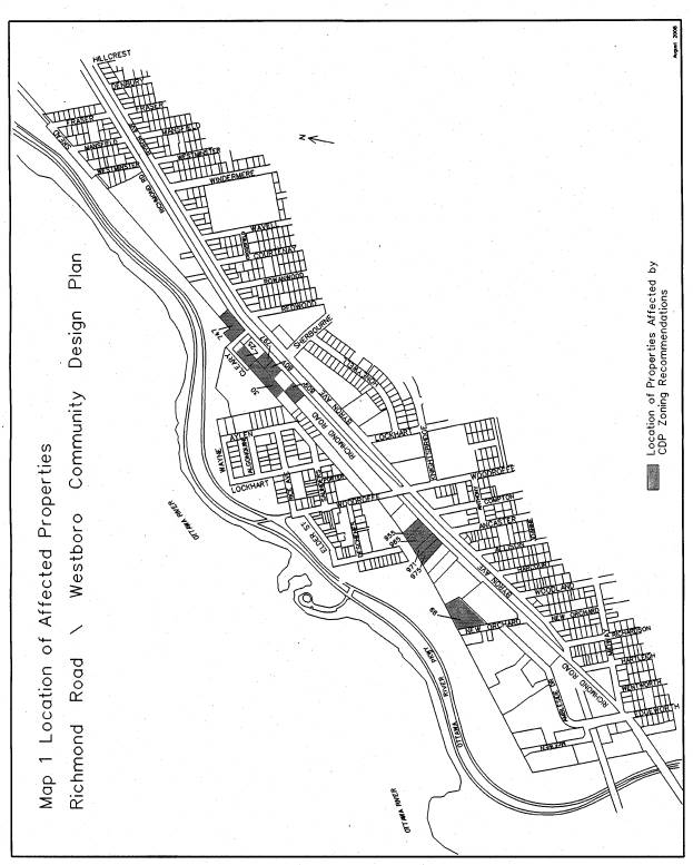
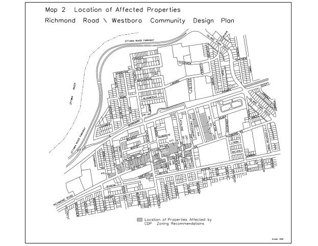
the factors considered in developing the recommendations. All owners whose
properties would be affected by the CDP's proposed zoning recommendations were
notified during the Zoning By‑law amendment circulation in March 2007.
In Planning and
Environment Committee's consideration of the CDP report on June 26, 2007, two
motions were referred to staff for consideration. The first motion was to retain the existing 24-metre height limit
on considerable portions of the two blocks bounded by Madison, Roosevelt, Byron
and Churchill Avenues. The CDP had
recommended that the maximum height of the block bounded by:
- Madison on the north, Roosevelt on
the west, Richmond Road on the south and Churchill Avenue on the east be
reduced from 24 to 18 metres;
- Richmond Road on the north,
Roosevelt on the west, Danforth Avenue on the south and Churchill Avenue
on the west be retained at 24 metres for the south half of the block and
be reduced from 24 metres to 18 metres for the north half fronting
Richmond Road.
The Committee's
motion was in response to a proponent who owned properties on both blocks and
who was planning to redevelop these properties in the future at the existing
24-metre height limit. After considering the Committee’s motion and the
property owner's submission, this report recommends that the existing 24-metre
height for the two blocks be retained as it is the Department’s view that the
blocks have sufficient depth and that the rear street provides an adequate
separation distance to provide an appropriate transition to the low-rise
residential neighbourhoods to the south of Byron and on the north side of
Madison. The blocks also have vehicular
access to the rear street. Buildings
facing onto Danforth or Madison would need to be appropriately articulated as a
front of a building and stepped back after the second or third storey. At a minimum, the Zoning By-law’s TM –
Traditional Mainstreet zone provisions for setbacks at or above the fourth
storey or 15 metres, whichever is lesser, will apply. On Madison, with low-rise residential uses on the north side, a
minimum setback of 3.0 metres will be required, with no maximum.
The other
Committee motion dealt with 351 McRae Street to include an automobile
dealership as a permitted use. An
automobile dealership is not permitted under the existing or proposed zoning.
It is staff's view that an automobile dealership should not be added to the
list of permitted uses as it would not be in keeping with the mixed use
pedestrian-oriented land use plan envisaged for McRae Street in the CDP. As the existing zoning allows a storage
yard, an exception is proposed to allow the storage of vehicles for sale as an
additional permitted use.
For 927 Richmond
Road/108 Woodroffe Avenue (northwest corner of Richmond/Woodroffe), the CDP had
recommended that these two properties be rezoned from an eight-storey to a
four- storey height limit. Following
Council’s approval of the CDP, those property owners consulted with the
Woodroffe North community and submitted a site plan control application for a
seven- storey mixed-use building. It is staff’s understanding that the community
supports the application, which is temporarily on hold at this time. Accordingly, the proposed zoning changes no
longer include these properties and the CDP will be amended accordingly as
described below under Recommendation 4.
RECOMMENDATION 3
On October 23,
2008 the Ontario Municipal Board approved the unappealed portions of the new
Comprehensive Zoning By-law 2008-250. Consequently, for most of this report’s
zoning recommendations it will be no longer necessary to also amend the former
City of Ottawa Zoning By-law 93-98.
However, the permitted uses in the new GM-General Mixed Use zone
continue to be under appeal. Thus, for the properties on McRae Avenue that are
proposed to be rezoned to GM, it will still be necessary to amend By-law 93-98
as summarized in Document 3.
RECOMMENDATION 4
The proposed
change in zoning recommendation for the two blocks bounded by Madison,
Roosevelt, Danforth and Churchill Avenues, as well as the northwest corner of
Richmond/ Woodroffe, discussed in Recommendation 2, requires an amendment to
the CDP as outlined in Document 4.
Technical
comments from City departments require a few minor wording corrections/updates
to the CDP that are included in the OPA in Document 2. For example, the Transportation Impact Management
Study, approved to be undertaken as part of the July 9, 2007 Council approval
of the CDP, was tied to the 2008 Transportation Master Plan update. The two studies are now to be independent of
each other. There is also an update to
the City’s Cycling Plan reference.
The Parks and
Recreation Branch noted that the OPA and CDP should reflect their position
supporting the preservation of the Atlantis-Selby lands and Rochester Field as
green space, but not dedication or designation as active recreational/programmable
City parkland. Finally, a correction to two addresses and update of the zoning
recommendations for the Richmond/Madison/Danforth blocks and 927 Richmond/108
Woodroffe in the CDP’s Appendix are also outlined in Document 4.
ENVIRONMENTAL
IMPLICATIONS
Adoption
of the OPA will facilitate the implementation of Richmond Road/Westboro CDP
intended to help enhance the planning area for residents, shoppers and visitors
alike. It will lead to future
streetscape improvements, enhance the pedestrian environment, confirm green
spaces for recreational activities, establish green links to the Ottawa River
corridor, and provide design guidance to address local microclimate conditions
potentially affected by future development.
CONSULTATION
The OPA included
a public and technical circulation as well as a notice of application
advertisement, which appeared in the Citizen and Le Droit on February 1, 2008.
Staff worked with the Ward Councillors and the Richmond Road/Westboro CDP
Planning Advisory Committee in developing the format for the Secondary
Plan. The proposed Zoning By-law
amendment was circulated to all affected property owners, in March 2007. In addition, the Richmond Road/Westboro CDP
entailed an extensive and detailed public consultation program.
A summary of the comments received and the
staff response is detailed in Document 5.
FINANCIAL IMPLICATIONS
The
Richmond Road/Westboro CDP, as contained in the OPA, has several initiatives
and studies that are follow-up measures to move forward the implementation of
the Plan. When these initiatives and studies come forward in future work
programs, they will have budget implications that will be addressed at that
time.
SUPPORTING DOCUMENTATION
Document 1 Location Map
Document 2 Official Plan Amendment - Richmond
Road/Westboro CDP
Document 3 List of Zoning By-law Changes and Location
Maps
Document 4 Amendment to the Richmond Road/Westboro
CDP
Document 5 Consultation Details
DISPOSITION
Legal Services
Branch to forward implementing by-laws to City Council.
Infrastructure
Services and Community Sustainability Department, Planning Branch to:
1. Prepare implementing Official Plan
Amendment and Zoning Amendment By-laws;
Location
Map DOCUMENT 1
LIST OF ZONING BY-LAW CHANGES AND LOCATION MAPS DOCUMENT 3
|
Address
|
Existing
Zoning
By-law
2008-250
|
Proposed
Zoning
By-law
2008-250
|
Existing
Zoning
Former
Ottawa
By-law
93-98
|
Proposed
Zoning
Former
Ottawa
By-law
93-98
|
|
99 New Orchard
|
GM1 -
General
Mixed-Use Zone
|
GM1 H (25)
Increase height limit from 18m to 25 m
|
N/A
|
N/A
|
|
975 Richmond
|
TM H(25)
|
TM H
(15)
Decrease height limit from 25m to 15m.
|
N/A
|
N/A
|
|
971 Richmond
|
TM H(25)
|
TM H (15)
Decrease height limit from 25m to 15m
|
N/A
|
N/A
|
|
955-65 Richmond
|
TM H(25)
|
TM H(15) Decrease height from 25m to 15m.
|
N/A
|
N/A
|
|
809 Richmond
|
TM [25]
|
TM [25] H (15)
West half -Decrease height limit from 20m
to 15m
East half - no change
|
N/A
|
N/A
|
|
797 and 801 Richmond
|
TM H(15)
|
TM
Increase height limit from 15m to 20m
|
N/A
|
N/A
|
|
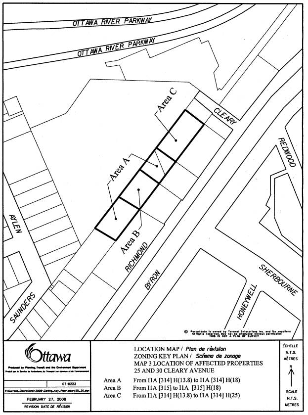
Parts of 25 and 30 Cleary
|
I1A [314] H (13.8); I1A [315] - Minor Institutional Zone
|
I1A [314] [315] H
(18 and 25) Increase height limit from
13.8m to 18m and 25m for part of 30 Cleary Avenue as shown on Map 3
|
N/A
|
N/A
|
|
747 Richmond
Part of 25 Cleary
|
TM
H(15)
|
Zoning enacted by the Ontario Municipal
Board
|
N/A
|
N/A
|
|
415 Richmond
|
TM H(24) Traditional Mainstreet Zone
|
TM H(15)
Decrease height limit from 24m to 15m
|
N/A
|
N/A
|
|
403 Richmond
|
TM H (24)
|
TM
Decrease height limit from 24m to 20m
|
N/A
|
N/A
|
|
395 Richmond
|
TM H (24)
|
TM H (15)
Decrease height limit from 24 to 15m
|
N/A
|
N/A
|
|
347, 361-369, 379 Richmond;
376 Madison
|
TM H(24)
|
TM [xxxx] H (24)
Add minimum setback from Madison Avenue
3m
|
N/A
|
N/A
|
|
345 Richmond
|
TM[9]
|
TM [9]
Add minimum setback from Madison Avenue
3m
|
N/A
|
N/A
|
|
322-32 Richmond
413 Churchill
|
TM H(24)
|
TM
Decrease height limit from 24 to 20m
|
N/A
|
N/A
|
|
319-27, 300-318 Richmond
|
TM H(24)
|
TM H (15)
Decrease height limit from 24 to 15m
300 Richmond
TM H(16) Decrease height limit from 24 to
16m
|
N/A
|
N/A
|
|
Part of 277 Richmond
307 Richmond
|
TM H(24)
|
TM
Decrease height limit from 24 to 20m
|
N/A
|
N/A
|
|
377-81 Winona
|
TM H(24)
|
TM
Decrease height limit from 24 to 20m
|
N/A
|
N/A
|
|
267-75; 288-98; 270-74 Richmond
396 Athlone
|
TM H(24)
|
TM H(15)
Decrease height limit from 24 to 15m
|
N/A
|
N/A
|
|
276 Richmond
|
TM H(24)
|
TM H(15)
Decrease height limit from 24 to 15m
|
N/A
|
N/A
|
|
256 Richmond
401 Athlone
406 Tweedsmuir
|
TM H(24)
|
TM
Decrease height limit from 24 to 20m
|
N/A
|
N/A
|
|
249-61 Richmond
|
TM H(24)
|
TM H(15)
Decrease height limit from 24 to 15m
|
N/A
|
N/A
|
|
205 Richmond
|
TM H(15)
|
TM
Increase height limit from 15 to 20m.
|
N/A
|
N/A
|
|
351 McRae
|
IG1 H(15) – General Industrial
|
GM [xxxx]
H (15)
Add:
- storage use limited to storage of
automobiles for sale as an additional permitted use.
- maximum height within 20 metres of a
residential zone - 11m
In all other cases -15m
|
IS [631] H (15)
|
CG [xxxx] H(15)
Add:
-storage use limited to storage of
automobiles for sale as an additional permitted use.
- maximum height within 20 m of a
residential zone - 11m
In all other cases - 15m
|
|
319 McRae
|
IG1
|
GM [xxxx]
Add maximum height within 20m of a
residential zone - 11m
In all other cases-18m
|
IS F (1.0)
|
CG [xxxx] F(1.0) Add:
- maximum height within 20m of a
residential zone 11m
- in all other cases 18m
|
|
Part of 320; and 344 McRae
|
IG1 H(15)
|
GM H (15)
|
IS [631] H (15)
|
CG H (15)
|
Amendment to the Richmond
Road/Westboro CDP DOCUMENT 4
AMENDMENT TO RICHMOND ROAD/WESTBORO
COMMUNITY DESIGN PLAN
The Richmond Road/Westboro Community Design
Plan is hereby amended as follows:
- Section 3.7 Transportation/Traffic Studies, sixth paragraph,
last sentence: delete the phrase “…as part of the 2008 update of the
TMP ”.
- Section 3.8 Bicycle Routes, be amended as follows:
a. Second paragraph, first sentence: replace: “…recreational…”
with “multi-use”.
b. Third paragraph, first sentence: replace “2005” with “draft
September 2007”; and, third sentence: add “and that Scott Street be
provided with bicycle lanes east of Churchill Avenue.”
- Section 3.9 Transit, first paragraph, third sentence: delete “…urgently
needs to…” with “must”.
- Section 6.3 Sector 2 – Woodroffe North. End of last paragraph:
add: “On September 16, 2008 the Ontario Municipal Board approved zoning
provisions that will create a height limit of eight storeys on the east
half of 747 Richmond Road and 12 storeys on the western half.”
- Section 6.6 Sector 5 –
Westboro Village:
a) Replace the fourth
paragraph, beginning with “ An exception to this recommendation…” by the
following text:
An exception to this recommendation is proposed for the block fronting
on both Richmond Road (south side) and Danforth Avenue and the block fronting
on both Richmond Road (north side) and Madison Avenue. In these cases the
existing eight-storey height limit should be retained as the blocks have
sufficient depth and the rear street provides sufficient separation distance to
provide an appropriate transition to the low-rise residential neighbourhoods to
the south of Byron and on the north side of Madison. The blocks also have vehicular access to the rear street. Buildings facing onto Danforth or Madison
would need to be appropriately articulated as the front of a building and
stepped back after the second or third storey.
At a minimum, the new TM zone provisions for setbacks at or above the
fourth storey or 15 metres, whichever is lesser, will apply. On Madison, with low-rise residential uses
on the north side, a minimum setback of 3.0 metres will be required, with no
maximum.
b) Add to the last paragraph “On August
28, 2008 City Council adopted a zoning by-law amendment permitting an eight
storey building on the eastern third of the site.”
- Section 6.9 Sector 8 -Westboro Beach/Atlantis Selby, first
paragraph: delete the word “park” from the following sentence:
"For Sector 8, the Atlantis
Selby lands also should be preserved as green space to provide both a local
community park and a city-wide attraction.”
7.
Section 9.3 Implementation
Actions, be amended as follows:
a)
First bullet point: delete at the end of the sentence “… and used for recreational activities, including sports fields.”
b)
Fifth bullet point: delete the last sentence “This plan should be included as part of the review and update of
the TMP in 2008.”
8.
Modify Appendix 1 as per
Document 3 – List of Zoning Changes and Location Maps.
9.
Replace Map 9a “ Proposed Maximum Building Height Changes –
West Sector” with the following map:
The map change is to retain the existing TM H(25)/CG4 [435] F(2.0)
H(24.7) for 927 Richmond Road and 108 Woodroffe.
10. Replace Map 9b “Proposed
Maximum Building Height Changes – East Sector” with the following map:
The map change is to retain the existing TM H (24)/CN2 [507] H (24)
F (2.0) for the two blocks bounded by Madison, Roosevelt, Danforth and
Churchill and to clarify the maximum number of storeys for 93-109 Richmond
Road.
CONSULTATION DETAILS DOCUMENT 5
In response to
the public and technical circulation of the Official Plan Amendment in January
2008, the following comments were received.
National
Capital Commission (NCC).
“Please note
that we have reviewed this from a Capital Planning perspective and support
numerous principles outlined in this OPA; including design concepts related to
improved linkages to recreation pathways, improving streetscape amenities,
implementing provisions to increase the landscaped areas and sidewalk widths
along main street corridors and retaining parkland (cash-in-lieu) fees in this
community. As noted in previous circulations of the CDP, we also continue to
have concerns with respect to the greenspace designations and illustrations of
passive open spaces to be confirmed via this CDP on federally owned lands. We do acknowledge some of the revisions in
the text to note that the Rochester Field site remains subject of an active
appeal to the OMB and therefore any designation and future land use(s) for this
site are, at this time, unconfirmed. We continue to take the position this CDP
does not appropriately reflect the NCC’s position for federal lands in the
study area. We refer specifically to the two NCC parcels, which are on the
edges of the Ottawa River Parkway (ORP) corridor, Rochester Field and lands in
the vicinity of Atlantis and Selby Avenues. (For example, Section 6.0-
Greenspace Network Strategy, policies in Sections 7.5 and 7.9 and Maps which
identify “confirmed greenspace” designations).
The NCC is
preparing the Capital Urban Lands Master Plan for federal land holdings within
the urban area. This federal level
master plan is comprised of evaluation, analysis and public consultation phases
and will ultimately develop policy and identify appropriate land use for
federal lands. Some sectors identified in the CDP are also the subject of this
master plan. We reiterate to the City that the NCC has the legislated authority
for the planning of federally owned lands within the Ottawa River Parkway
corridor lands. The Capital Urban Lands Master Plan will examine the Ottawa
River Parkway corridor in some detail, with provisions for full public
consultation and we look forward to integrating to the greatest degree possible
the requirements for federal lands with the evolving maturation and
diversification of the Richmond Road community.”
Staff
Response
Woodroffe
North Community Association
The Woodroffe
North Community Association's confirms its unconditional support for the
proposal to make the Richmond Road/Westboro Community Design Plan (CDP) a
secondary plan to the City of Ottawa's Official Plan. For many
years, spot zoning along Richmond Road from Cleary to New Orchard has resulted
in land uses, which have not been compatible, in the majority of cases, with
our exclusively residential community. Over the last decade, our members
have responded to a number of development proposals but we were not equipped
with any official policy or plan to assist us in ensuring a fair and
appropriate balance between the interests of Richmond Road landowners and our
residents. Secondary Plan status for the CDP will be a valuable tool
which will equip both developers and our members to work together guided
by the vision, principles and long-term development objectives for our
stretch of Richmond Road.
Staff
Response
OFFICIAL
PLAN AMENDMENT AND ZONING BY-LAW AMENDMENT - RICHMOND ROAD/WESTBORO COMMUNITY
DESIGN PLAN
modification au plan officiel et modification au règlement de zonage –
plan de conception communautaire du chemin richmond/westboro
ACS2008-PTE-PLA-0061 Kitchissippi (15), Bay/Baie
(7)
(This
matter is subject to Bill 51)
The
following correspondence was received and is held on file with the City Clerk:
·
Comment sheet from Jane Ironside, on behalf of Domicile
Developments Inc., received on September 23, 2008
·
Submission from Lloyd Phillips dated September 16,
2008, on behalf of Domenic Cassone, the owner of 300 Richmond Road
·
Email from Tom Trottier dated September 16, 2008
·
Submission from Lynne Racine dated September 18, 2008
Councillor
Leadman requested that the matter be deferred to allow further staff review.
John
Moser, Director of Planning, indicated staff do not object to a referral to
review the concerns recently raised by Councillor Leadman.
In response
to questions from Councillor Cullen, Richard Kilstrom, Manager of Community
Planning and Design confirmed the issue raised by Councillor Leadman is the
definition of building height (low, medium and high). He stated the number of storeys reflect definitions in other
secondary plans from the former City of Ottawa, including Centretown. Mr. Kilstrom added that the Community Design
Plan continues to have status in its entirety.
The
following delegations were present and consented to referral/deferral:
·
A. Walter Loates, on behalf of Walter Boyle
·
Gary Ludington, Westboro Community Association
·
Lloyd Phillips, on behalf of Dominic Cassone
The
Committee also received assurances that both Ward Councillors would be kept
informed going forward.
Moved by
J. Harder:
THAT this matter be referred back to staff for further clarification
and rise to the meeting of 14 November 2008.
CARRIED
That Planning and
Environment Committee recommend Council:
1.
Approve an amendment to the
Official Plan for the City of Ottawa, Volume 2A, to incorporate the Richmond
Road/Westboro Community Design Plan as a Secondary Plan as detailed in Document
2 (distributed separately and on file with the City Clerk).
2.
Approve an amendment to Zoning By-law 2008-250 of the City of Ottawa
as shown on the location maps and detailed in Document 3.
3.
Approve an amendment to the former City of Ottawa Zoning By-law,
93-98 as shown on the location maps and detailed in Document 3.
4.
Approve an amendment to the Richmond Road/Westboro Community Design
Plan as detailed in Document 4.
REFERRED/DEFERRED
To November 14, 2008
OFFICIAL PLAN
AMENDMENT AND ZONING BY-LAW AMENDMENT - RICHMOND ROAD/WESTBORO COMMUNITY DESIGN
PLAN – REVISION
modification au plan officiel et modification au règlement de zonage -
plan de conception communautaire du chemin richmond/westboro - RéVISION
acs2008-ics-pla-0228 Kitchissippi (15), Bay/Baie
(7)
Deferred
on 23 September 2008 - Original Report: ACS2008-PTE-PLA-0061 / Reporté le 23
septembre 2008 - Rapport original :
ACS2008-PTE-PLA-0061
(This matter is subject to Bill 51)
Richard Kilstrom, Manager of
Community Planning and Design, provided a PowerPoint presentation, which is
held on file with the City Clerk. He
noted that the only change from the first report is how height is defined with
a specific range of storeys now outlined (e.g. low profile is defined as under
four storeys). He was accompanied by
the following:
·
John
Moser, General Manager of Planning and Growth Management
·
Françoise Jessop, Program Manager, Zoning Studies
and Area Planning Central
·
Robert Spicer, Planner III
Councillor Desroches asked why a
community design plan (CDP) would be finalised before the approval of the
Transportation Master Plan (TMP). He
referenced Riverside South as an example, where the CDP was developed on the
assumption that the community would be serviced by transit. Mr. Kilstrom advised that CDPs are not done
in isolation and would be amended, if required, once the TMP is passed. Mr. Spicer added that the Infrastructure
Approvals division hired a consultant as part of the CDP process to do an
infrastructure capacity study, which was reflected in the plan.
Councillor Leadman clarified the
difference between this CDP and Riverside South, noting Westboro/Richmond Road
is an existing area facing intensification, not a greenfield development.
Mr. Spicer confirmed that Council
previously approved that the CDP be given secondary plan status, which has
resulted in the Official Plan and Zoning amendments before committee.
In response to questions from
Councillor Harder with regard to the TMP and risk, Mr. Kilstrom indicated
this plan is not designed around either option for light rail transit (Byron
Avenue or Ottawa River Parkway). He
reiterated that the plan would be amended when a decision on the route is
final. He emphasized that the
CDP/secondary plan is needed to help guide development in the area.
Mr. Moser stated that land
acquisition, if required, for the transit corridor would occur after the
completion of an Environmental Assessment (EA). He added that this plan is transit-supported and speaks to
intensification potential. He said that
the Byron right-of-way is in City ownership.
Councillor Hunter touched on the
issue of property acquisition for transit, recalling a decision by the former
Region to dispose of key land holdings that might be required for a light rail
transit route in the area.
Councillor Cullen countered that
key parcels are still available for light rail, including the Byron Linear
Park, McEwen Park and Rochester Fields.
He reiterated that this land use plan speaks to how this established
community would handle intensification.
In response to further questions
from Councillor Leadman, Mr. Kilstrom posited that a development freeze along
the transit corridor is not necessary.
Mr. Moser concurred, noting that the EA process, which takes 18 months
to two years to complete, will look at various transportation options and has
not commenced. EAs are funded from an
on-going dedicated budget.
Chair Hume commented that
speculating on the results of an EA, yet to be completed, is not a productive
use of the Committee’s time.
Councillor Doucet focussed on
community involvement in the preparation of the plan and expectations in that
regard.
Brian
Cassagrande, FoTenn Consultants, accompanied by Brad Hutt, spoke on
the broad development interests of Ashcroft in the Westboro area and
site-specific interests of the Unsworth Family (1976 Scott, 319 McRae, 320
McRae).
With
regard to 1976 Scott Street, the site presents a unique opportunity for
redevelopment of industrial lands. The
site is currently used as a used car dealership across from a transit station,
the Metropole and the trailhead facility.
The CDP envisions a mixed-use development for the lands, also planned by
the Unsworth Family. As the site is
across from a transit station, Mr. Cassagrande advanced that the City and the
CDP should be open to opportunities to capitalize on intensification and height
at that location. He indicated the
project is in its infancy and the community will be invited to participate in
an open and inclusive process, resulting in an exciting development.
Mr. Hutt,
an architect and project manager also representing the Unsworth Family,
commented that the family is not interested in selling the property to a large
developer; instead, the estate wishes to develop the land in a conscientious
way, respecting the family legacy and the community of which they have been a
part of for many generations.
Mr.
Cassagrande summarized that the secondary plan appears to be removing the
ability that currently exists within the Official Plan (OP) for the City to
consider development with greater height and density when the location and
design of the project mitigate the impact and promote broader City and
provincial objectives, such as intensification and public transit. He suggested OP policies and guidelines
allow for unique development applications to be considered without the
requirement for an OP or Secondary Plan Amendment.
He
suggested wording changes to Section 1.2 (objectives), Principle 5, point 3,
second sentence, to begin with: “Higher buildings will be considered on sites
…” He also advanced that the ability to
support public transit at these locations should be a strong consideration and
added to the sentence. Section 2.7 of the appendix, which offers additional
criteria for evaluating intensification, should refer to the criteria outlined
above (height and flexibility).
Specifically
at 1976 Scott Street, Mr. Casagrande advised that the maximum height of four to
six storeys should be revised, as a greater height of 10 or more storeys is
appropriate. The site is slightly
deeper than shown on the map and immediately across a transit station and an
existing 30-storey building. He also
expressed concern with Scott Street’s ability to develop as a main street with
the Transitway running on one side. He
advanced that the City should focus on achieving reasonable density targets on
Scott.
With
regard to 319 and 310 McRae, Mr. Cassagrande requested Section 1.4 of the
appendix be revised to provide more flexibility with regard to the hydro
corridor. With regard to the GM zone
applied to the eastside of McRae, two provisions are of concern: the FSI limit
of 2.0 and stepping of height (11 metres permitted within 20 meters of the
residential zone, which is more restrictive than the angular building plane
contemplated in the TM zone).
In
response to a question from the Chair, Tim Marc, Senior Legal Counsel confirmed
the Traditional Mainstreet designation on Scott Street was upheld at the
Ontario Municipal Board (OMB).
Mr. Spicer
indicated it is the first time these concerns have been brought to the
attention of staff. For the properties
along McRae, he indicated the existing building heights and rear yard set back
provisions were carried forward in the new GM zone, because the lots on the
west side of McRae, adjoining a low-rise residential area, are shallow. The public advisory committee did involve
FoTenn, which made representations on other sites.
Mr.
Cassagrande indicated that he would present his arguments in writing.
Gary
Ludington, Westboro Community Association touched on his
on-going participation for more than three years on the CDP and secondary
plan. He noted the private sector
participated in the process with a representative on the public advisory
committee. He added that site-specific
issues could be addressed through the development approval process as projects
come forward. He spoke in support of
the adoption of the secondary plan, noting recent challenges to the CDP at the
OMB. He clarified that with the
secondary plan becoming part of the Official Plan, the CDP will remain as a
policy document to help guide development.
Walter
Loates, Dynar
Architect + Associates Inc., addressed concerns on behalf of Walter Boyce, owner of 809
Richmond Road. He requested that the
property enjoy the same permitted mid-height across the site, reflective of the
adjacent two apartment buildings. An
18-meter height limit has been enjoyed on the easterly half of the site;
however, the westerly portion is proposed to be downzoned to 15 metres. The owner is in negotiations to build a
retirement home. A shadow study for a
mid-height building was undertaken at three points throughout the day, over the
course of a year, that demonstrated no overshadow impact. Mr. Loates noted that
there are approximately 19 metres between the northwest corner of the site and
the closest residential property, but a stepped building would result in a
38-meter separation or day lighting. He
added that the residents in the affected area are overshadowed already by the
adjacent Lord Richmond apartments. A
spatial separation of 25 to 40 metres exists between the residential community
and the Lord Richmond east wall due to surface parking. In addition, he reiterated that the request
for increased height is a result of the proposed senior retirement housing,
which is needed in the community, and the required density to make the project
economically viable. A letter dated
October 26, 2007 and shadow drawings were submitted and are held on file with
the City Clerk.
Replying to a question from
Councillor Leadman, Mr. Loates confirmed the applicant would be required to
make a re-zoning application regardless.
Lloyd Phillips, Lloyd Phillips &
Associates Ltd., on behalf of Domenic Cassone, spoke in relation to
300 Richmond Road. He said that minor
variances were approved by the OMB for a five-storey mixed use building
comprised of 20 apartments on upper floors and retail at grade. With respect to the transitional provision
of the new comprehensive zoning by-law, Mr. Phillips requested that the
three-year window be extended as the project might not be constructed within
that period. He also affirmed that the
height for the property should be four to six storeys, noting his client
opposes the permitted height of less than four storeys. The CDP imposes a 15-meter height limit, as
opposed to the 24 metres currently permitted.
Under the previous zoning, the setback from the lane at the rear was
zero. The OMB decision stated that the
proposal was consistent with the Provincial Policy Statement and intent of the
Official Plan. In summation, Mr.
Phillips requested that the minor variance approved by the OMB be made permanent
through zoning. A letter dated November
3, 2008, outlining these arguments, is held on file with the City Clerk.
Ms. Jessop
commented that the three-year transition provision of the comprehensive zoning
by-law is generous and more than the two years previously set out in the former
Ottawa by-law. Mr. Marc agreed and
noted that a rezoning application is more permanent and not subject to the
three-year rule imposed on minor variances.
Moved by P. Feltmate:
WHEREAS for the Richmond
Road/Westboro Secondary Plan in Document 2, the wording describing the Ontario
Municipal Board September 16, 2008 decision on 747 Richmond Road is proposed to
be changed to more accurately represent the outcome of that decision. This will also require a change to Document
4.
THEREFORE BE IT RESOLVED:
1. That
Document 2, Part B - The Amendment, Section 1.3.4 b) be amended by deleting the
second bullet point and replacing it with the following:
·
“Recognize that for property at 747 Richmond Road,
the Ontario Municipal Board has approved heights of eight to twelve
storeys on the basis of measurements specifically outlined in
the Ontario Municipal Board's decision and reflected in the approved
zoning by-law.”
2. That
Document 4, Amendment to the Richmond Road/Westboro CDP, be amended by deleting
4. and replacing it with the following:
4. Sector 6.3 Sector 2 -Woodroffe
North, end of last paragraph, be amended by adding:
“However, on September 16, 2008, the Ontario
Municipal Board approved heights of eight to twelve storeys on the basis
of measurements specifically outlined in the Board's decision and
reflected in the approved zoning by-law.”
That there
be no further notice pursuant to Section 34 (17) of the Planning Act.
CARRIED
That Planning and
Environment Committee recommend City Council:
1. Approve an amendment to the Official
Plan for the City of Ottawa, Volume 2A, to incorporate the Richmond
Road/Westboro Community Design Plan as a Secondary Plan as detailed in Document
2 (distributed separately and on file with the City Clerk), as amended by
deleting the second bullet point in Part B – The Amendment, Section 1.3.4 b)
and replacing it with the following:
“Recognize that for
property at 747 Richmond Road, the Ontario Municipal Board has approved heights
of eight to twelve storeys on the basis of measurements specifically outline in
the Ontario Municipal Board’s decision and reflected in the approved zoning
by-law.”
2. Approve an amendment to Zoning By-law
2008-250 of the City of Ottawa as shown on the location maps and detailed in
Document 3.
3. Approve an amendment to the former City
of Ottawa Zoning By-law, 93-98 for 319, part of 320, 344 and 351 McRae Avenue
as shown on the location maps and detailed in Document 3.
4. Approve an amendment to the Richmond
Road/Westboro Community Design Plan as detailed in Document 4, as amended by
replacing item 4 to read as follows:
Sector 6.3 Sector 2 –
Woodroffe North, end of last paragraph, be amended by adding:
“However, on September
16, 2008, the Ontario Municipal Board approved heights of eight to twelve
storeys on the basis of measurements specifically outlined in the Board’s
decision and reflected in the approved zoning by-law.”
CARRIED as amended with S.
Desroches dissenting.